Off-Road Trails in Idaho
Discover off-road trails in Idaho

Learn more about Bull Trout Lake
Bull Trout Lake
Total Miles
2.5
Tech Rating
Easy
Best Time
Fall, Summer, Spring
Learn more about Bulldog Loop
Bulldog Loop
Total Miles
35.8
Tech Rating
Easy
Best Time
Spring, Summer, Fall
Learn more about Burchertt Spring #5236
Burchertt Spring #5236
Total Miles
2.3
Tech Rating
Moderate
Best Time
Summer, Fall
Learn more about Burgdorf to French Creek
Burgdorf to French Creek
Total Miles
27.0
Tech Rating
Easy
Best Time
Spring, Summer, Fall
Learn more about Burns Creek, Hell Hole, and Coalmine Access
Burns Creek, Hell Hole, and Coalmine Access
Total Miles
1.6
Tech Rating
Difficult
Best Time
Spring, Summer, Fall
Learn more about Burns Trout Creek Trail
Burns Trout Creek Trail
Total Miles
4.7
Tech Rating
Easy
Best Time
Summer, Fall

Learn more about Burnt Knob Lookout
Burnt Knob Lookout
Total Miles
1.6
Tech Rating
Easy
Best Time
Summer, Fall
Learn more about Butcher Knife 
Butcher Knife
Total Miles
5.0
Tech Rating
Easy
Best Time
Spring, Fall, Summer
Learn more about Buttar Springs Trail 7922
Buttar Springs Trail 7922
Total Miles
6.2
Tech Rating
Easy
Best Time
Spring, Summer, Fall
Learn more about Butterfly Loop
Butterfly Loop
Total Miles
3.4
Tech Rating
Easy
Best Time
Fall, Summer, Spring
Learn more about C-46 Plane Crash Site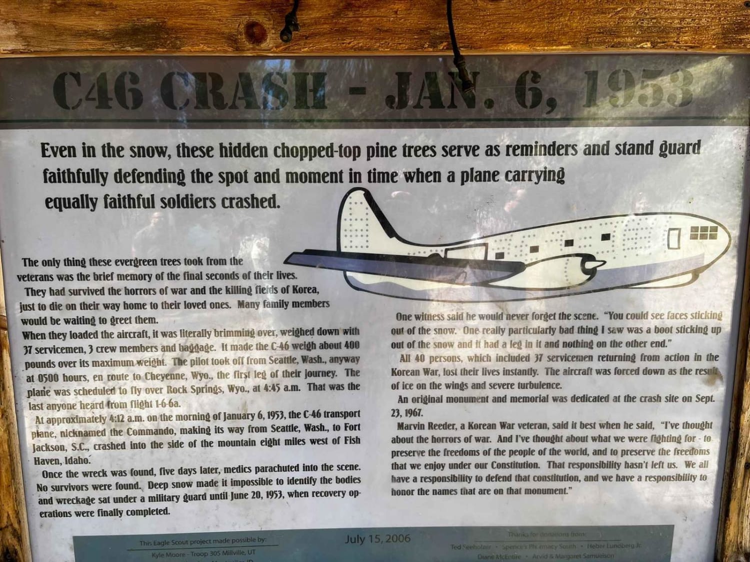
C-46 Plane Crash Site
Total Miles
6.7
Tech Rating
Easy
Best Time
Summer, Fall

Learn more about Cabin Point 
Cabin Point
Total Miles
8.2
Tech Rating
Moderate
Best Time
Spring, Summer, Fall
Learn more about Callen To Whisky Creek Overlook
Callen To Whisky Creek Overlook
Total Miles
2.2
Tech Rating
Easy
Best Time
Summer, Spring, Fall
Learn more about Camas Creek Road
Camas Creek Road
Total Miles
3.2
Tech Rating
Easy
Best Time
Spring, Summer, Fall
Learn more about Camas Creek Trail
Camas Creek Trail
Total Miles
2.4
Tech Rating
Easy
Best Time
Summer, Fall
ATV trails in Idaho
Learn more about Aspen Range - Middle Sulphur #5248 
Aspen Range - Middle Sulphur #5248
Total Miles
1.9
Tech Rating
Easy
Best Time
Summer, Fall
Learn more about Dry Fork - Meadow Springs #5226 
Dry Fork - Meadow Springs #5226
Total Miles
0.4
Tech Rating
Easy
Best Time
Summer, Fall
Learn more about South Foothill Road
South Foothill Road
Total Miles
8.2
Tech Rating
Moderate
Best Time
Summer, Fall

UTV/side-by-side trails in Idaho
Learn more about South Foothill Road
South Foothill Road
Total Miles
8.2
Tech Rating
Moderate
Best Time
Summer, Fall

Learn more about 21 To Nip & Tuck
21 To Nip & Tuck
Total Miles
1.4
Tech Rating
Easy
Best Time
Fall, Summer, Spring

The onX Offroad Difference
onX Offroad combines trail photos, descriptions, difficulty ratings, width restrictions, seasonality, and more in a user-friendly interface. Available on all devices, with offline access and full compatibility with CarPlay and Android Auto. Discover what you’re missing today!