Turkeys have a specific set of needs—water, diverse cover, and open areas—so the strategy for finding more turkeys is putting yourself where it makes sense for them to be. Simple, right? Whether you are hunting Easterns in the big woods or Rios in open country, success starts with understanding the landscape before you set foot in the woods. Learn how to identify likely turkey habitat using onX Hunt.
TL;DR: Turkeys live where their “big three” needs overlap (water, diverse cover, and open areas) especially along habitat edges like hardwoods meeting pine, wetlands, clearcuts, or fields. Use onX Hunt to find legal places to hunt by toggling public/private boundaries, locating access points, and identifying walk-in access properties. Then e-scout high-probability terrain: ridges/knobs for roosting and listening, saddles and benches for travel and strutting (Lidar helps), and drainages/creek bottoms for cooler, food-rich cover. Build a color-coded Waypoint system (e-scout vs. confirmed sign/gobbles) and download Offline Maps so you can navigate boundaries, layers, and pins when service drops.
Find Public Land for Turkey Hunting
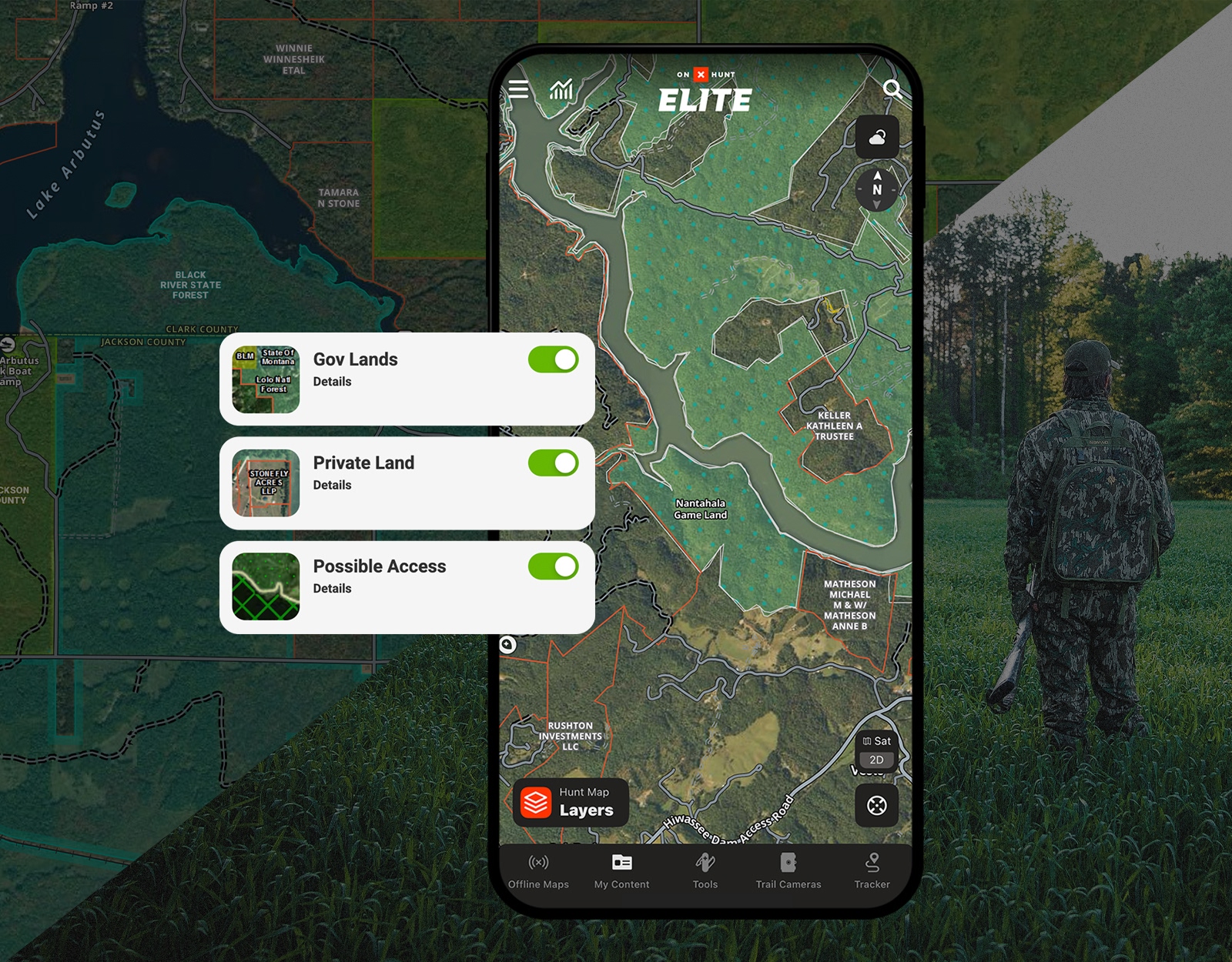
Public land offers incredible opportunities, but you need to know where the boundaries are to hunt legally and confidently. It’s easy to use the onX Hunt App to identify legal access points, public/private boundaries, and specific turkey management units.
In addition to federal and state public lands, look for private lands open to public hunting. States often have walk-in access programs (like Block Management or Access Yes!) that open up prime habitat that might otherwise be inaccessible.

Hunting Regs Without the Hassle
Compliance shouldn’t be the hard part. FieldRegs is a free app from the team behind onX Hunt that helps you quickly find hunting regulations, seasons, and legal requirements without digging through agency websites and PDFs. No credit card required.


Identify Turkey Habitat: Look for Diversity and Edges
Turkeys thrive in diversity. Look for areas that contain the “big three” factors in close proximity: water, diverse cover types, and open areas.
Water: Generally, moving water seems to trump still water. Look for seasonal drainages and small tributaries; these smaller, often more secluded water sources seem to attract turkeys.
Diverse Cover: Find where deciduous and coniferous trees mix or overlap, or where hardwoods meet a wetland area. These habitat edges create a mix of different cover types, diverse forage, and potential roost sites.
Open Areas: Think agricultural fields, open pastures, or even roads and small clearings in timber will do the trick.
As Jared Larsen from onX explains in this video, “Turkeys really thrive in diverse habitats even more so than really any other game species… if you can find edges of both hard and soft woods—and combine that with some water—more than likely you’re going to have a gobbler in the area.”
Use these onX Hunt Layers to find high-probability areas:
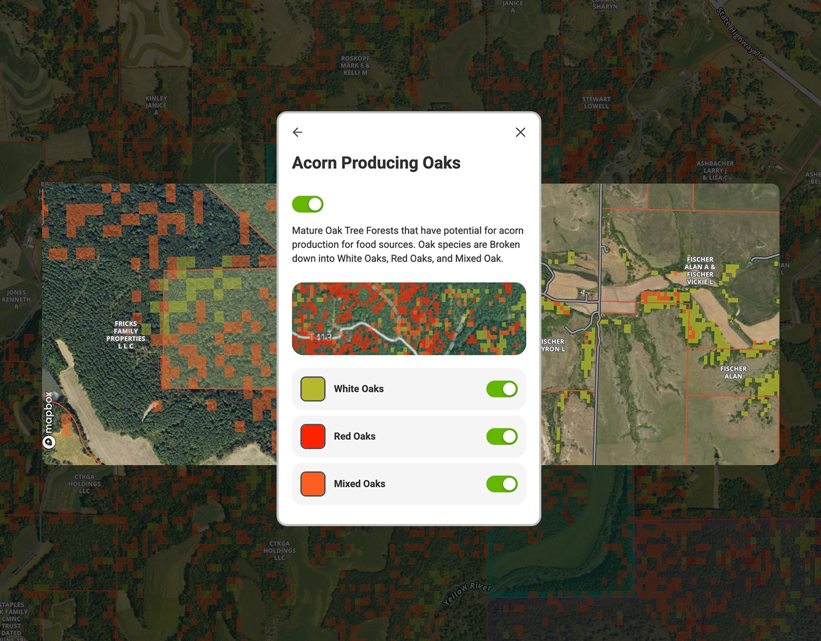
• Tree Species Layers: In vast pine forests (common in the Southeast), turkeys need hardwood creek bottoms for mast (food) and roosting. As Aaron Warbritton from The Hunting Public notes in this Masterclass, “They really depend on these hardwood stands…not only for roosting but for acorn production.”
• Crop Data Layers: In agricultural areas, turkeys will use crop fields for strutting and feeding. However, these “field turkeys” can be difficult to hunt because they rely on their keen eyesight. In onX Hunt and Mossy Oak’s Turkey Academy, it’s advised that you avoid setting up right on the field edge. Instead, set up 30 yards back in the timber so you remain hidden if the turkey inspects your calling.
• Timber Cuts Layer: Fresh clearcuts or thinned timber provide nesting cover and bugging grounds. Turkeys love the fresh growth in these disturbed areas.
Understand How Turkeys Use Terrain
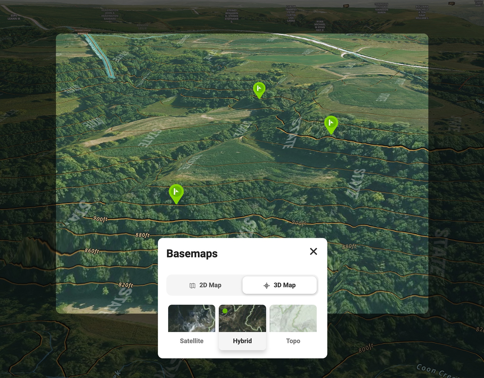
Once you have identified the right habitat, you need to understand how turkeys move through it. The Hybrid Basemap is the best tool for turkey e-scouting because it combines the visual detail of satellite imagery with topographic lines. Turn it on via the button in the lower right-hand corner of the screen in the Hunt App.
Knobs and High Points
Topography dictates how you should scout. In hilly terrain, use the 3D Map mode to identify high knobs and ridges. These are crucial for two reasons:
1. Roosting: Turkeys often roost off the edge of a ridge or knob where they can easily sail out. Note: When approaching a roost identified on your map, remember that early-season foliage is thin. Experienced turkey hunters advise staying further back than you think is necessary—often more than 100 yards—to avoid being seen from the tree.
2. Listening: You need to be where you can hear. Before you drive to a spot, identify “listening locations” that allow you to cast your hearing across multiple drainages.
Open Country Considerations
In open landscapes (like the Great Plains), trees are the limiting factor. Use your map to find riparian areas (creek bottoms) with cottonwoods. As Aaron Warbritton from The Hunting Public explains, “Sometimes it just takes a few of the right cottonwoods that you know 90% of the turkeys in the whole area will use to roost in.”
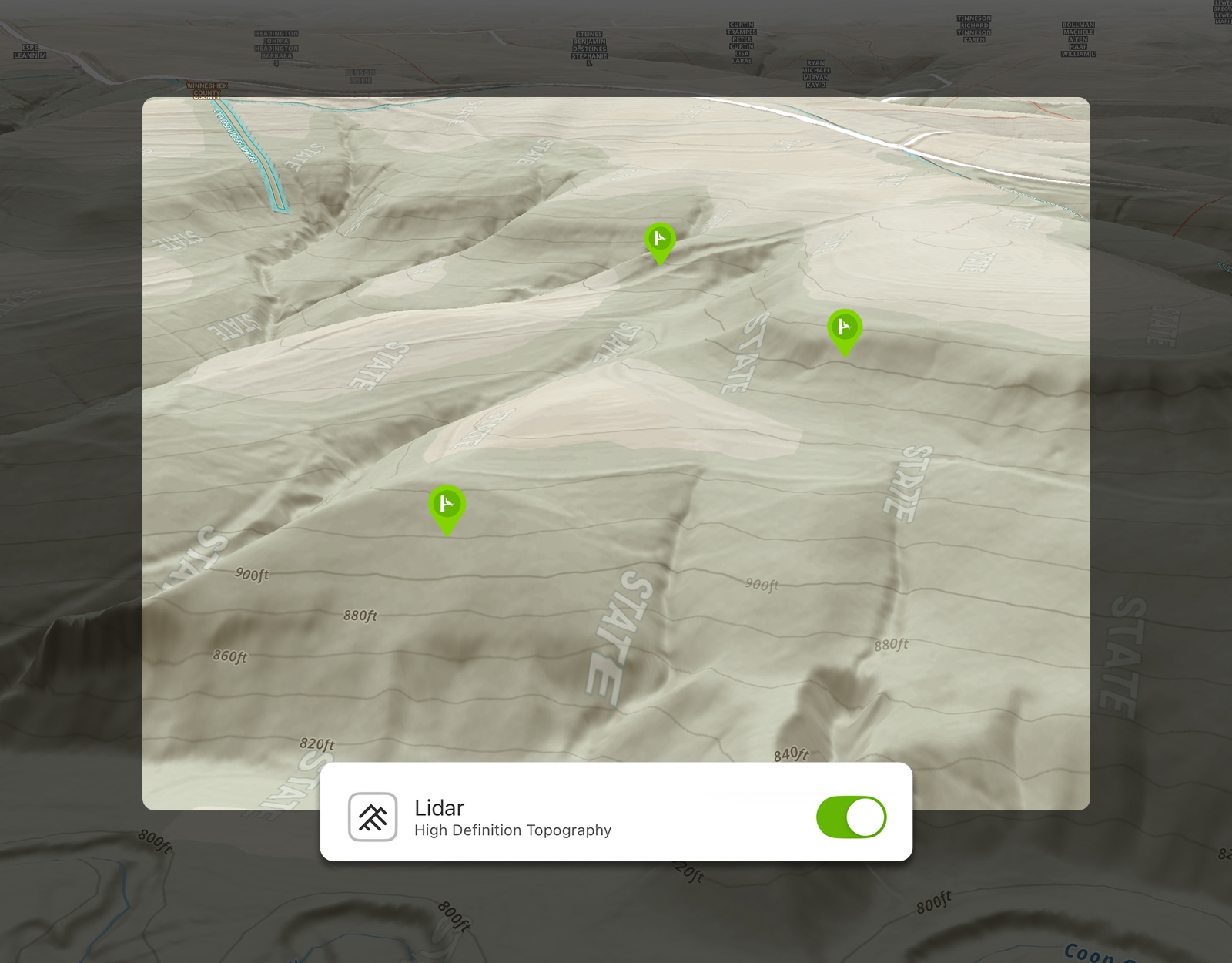
Saddles and Benches
Turkeys prefer the path of least resistance. Look for saddles (low points between two high points) and benches (flat areas on the side of a steep hill)—the Hunt App’s Lidar Maps will help you here. Gobblers love to strut on benches because they offer visibility and easy travel without exposing them to the skyline.
Drainages and Creek Bottoms
In hot weather or heavily pressured pine thickets, creek bottoms act as a magnet. They offer water, cooler temperatures, and usually the most diverse vegetation. If you are struggling to find birds on the ridges, drop into the drainages.
Develop a Turkey Scouting Waypoint System
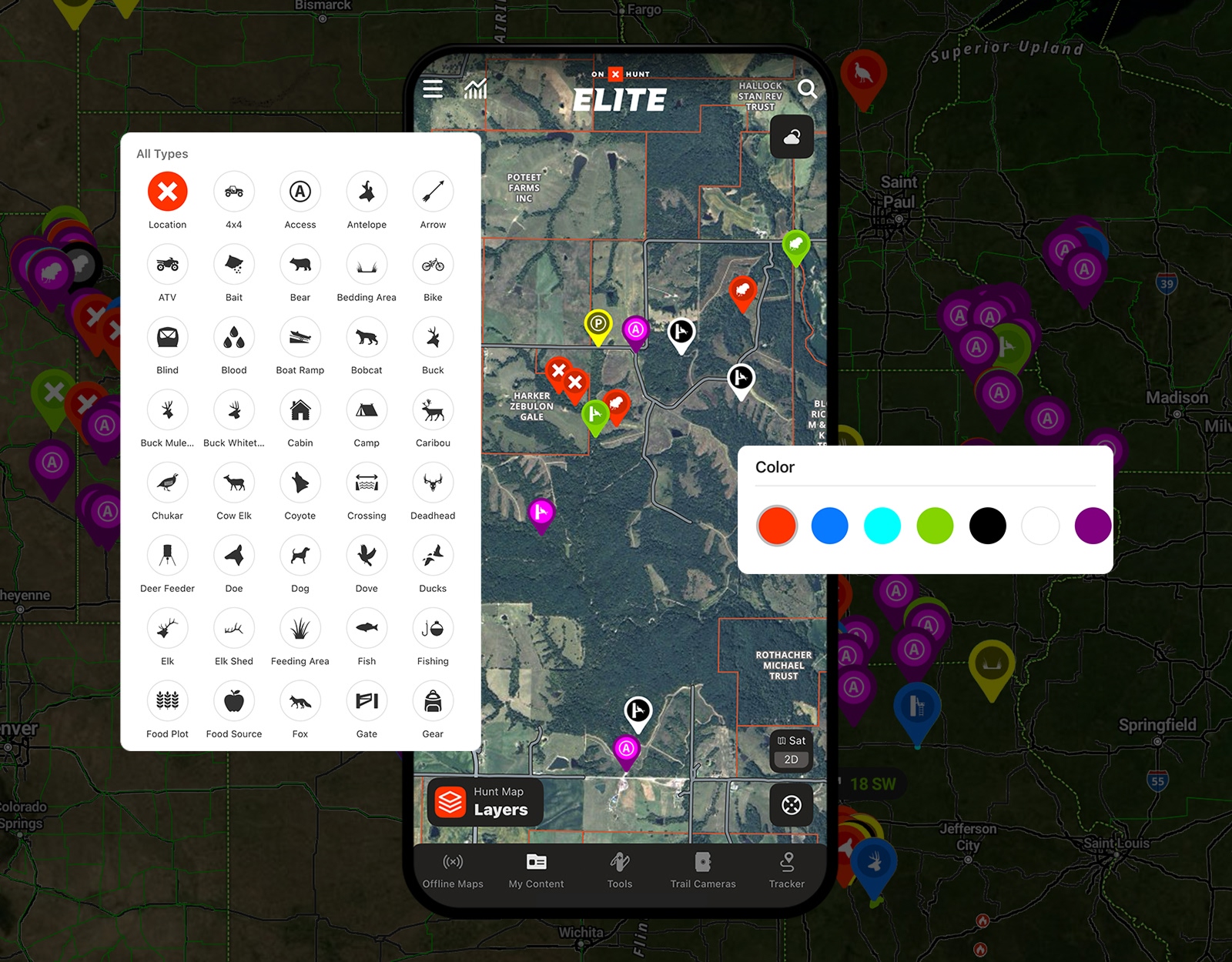
Organization is key to effective scouting. Develop a color-coded system for your Waypoints to keep your “suspected” spots separate from your “confirmed” spots.
Jared from onX shares his personal system: “If I’m scouting from home, I’ll often use the color white in areas that I’ve never been… whereas I’ll use blue… for spots where I actually found birds.”
• White Waypoints (E-Scouting): Mark spots that look good on the map before you ever leave the house.
• Blue/Red Waypoints (Live Action): Use a different color (like blue) to mark actual turkey sign—scat, tracks, or a roost tree. Use red to mark where you actually heard a gobble or spotted the gobbler.
• Custom Icons: You can also use specific icons for “Roost,” “Strut Zone,” or “Gobbler” to keep your map uncluttered.
Download Offline Maps, When Needed
Turkey hunting often takes you deep into bottoms or rural areas with spotty cell service. Before you leave home, download Offline Maps to save high-resolution maps of your hunting area. This ensures you still have access to your Map Layers, property boundaries, and Waypoints even when your phone is in airplane mode.


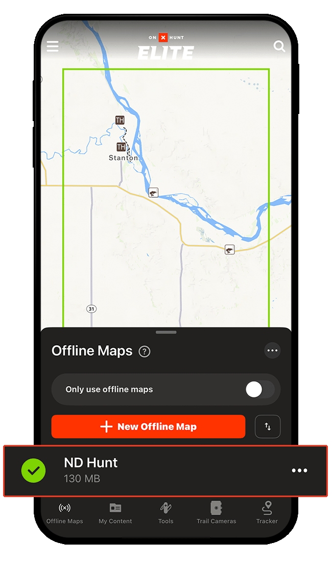
How To Save an Offline Map
Putting It All Together
E-scouting gives you a starting point, but you have to go see if you are right. Go to your “white Waypoints” and listen at dawn. If you hear a turkey, drop a pin on his location using Compass Mode’s built-in Rangefinder to estimate his distance from you.
Then, analyze the map: Why was he there? Was it a steep drop-off? A hidden bench? Once you figure out the pattern, you can repeat the process everywhere.
FAQs
If a gobbler is unresponsive because he is with hens, patience is your best tactic. Woodsmanship matters more than calling in this scenario. Use the terrain to shadow the flock and look for opportunities when the hens drift away to nest later in the morning.
This is common behavior. The gobbler likely flew down to meet his hens, so he has no reason to gobble. Do not charge in; instead, be patient. The “lull” often ends mid-morning (around 9:30 or 10:00 AM) when hens leave to nest, making the gobbler vulnerable to calling again.
Start with e-scouting on onX Hunt. Look for the intersection of roosting habitat (large trees/ridges), water, and food sources. Mark potential listening knobs with Waypoints. Then, visit these areas at dawn to listen for gobbling on the roost.
The best habitat offers diversity. Look for “edges” where hardwood timber meets open fields, clearcuts, or pine thickets. Turkeys need open areas to strut and feed, but mature timber to roost and hide.
Turkeys require different environments for different daily activities: roosting, feeding, strutting, and nesting. Areas with high habitat diversity (timber, water, crops, and brush in close proximity) hold more birds because they don’t have to travel far to meet all their survival needs.