Off-Road Trails in Missouri

Discover off-road trails in Missouri

Learn more about Red Oak School - FS 145B
Red Oak School - FS 145B

Red Oak School - FS 145B

Red Oak School FS 145B is a natural terrain forest service road within the Mark Twain National Forest Ava Unit. This is a secondary spur road off the primary road Pond Fork FS 145, both…
Learn more about Red Oak School - FS 145B
Total Miles
0.5
Tech Rating
3Easy
Best Time
Spring, Summer, Fall, Winter
Learn more about Red-Green 52
Red-Green 52

Red-Green 52

Red-Green 52 starts at Through Traffic 45 at one end and connects over to Green 14 at the other end. It is non-directional so you can run it from either direction. Once you are past…
Learn more about Red-Green 52
Total Miles
0.4
Tech Rating
8Difficult
Best Time
Spring, Summer, Fall, Winter
Learn more about Reynolds - CR 468
Reynolds - CR 468

Reynolds - CR 468

The Reynolds County Road 468, what could be known as the Lower or South Black River Bottoms Access Road, is a gravel-based county road that makes its way through the US Army Corps of Engineers…
Learn more about Reynolds - CR 468
Total Miles
4.2
Tech Rating
1Easy
Best Time
Spring, Summer, Fall, Winter
Learn more about Reynolds Ford Road
Reynolds Ford Road

Reynolds Ford Road

The Reynolds Ford Road is a road compromised of two county roads, the Bollinger County Road 336, and the Cape Girardeau County 350, that directly connect at the county line. The Cape Co side is…
Learn more about Reynolds Ford Road
Total Miles
7.4
Tech Rating
1Easy
Best Time
Spring, Fall, Summer
Learn more about Ride Hook
Ride Hook

Ride Hook

This is a short and sweet non-directional offshoot of the Jeep Badge of Honor Trail called Guardrail. There are no obstacles on this trail. There are steep grades both up and downhill along the way.…
Learn more about Ride Hook
Total Miles
0.1
Tech Rating
3Easy
Best Time
Spring, Summer, Fall
Learn more about Ridge Run North
Ridge Run North

Ridge Run North

Starting at the top ridge just before Happy Hollow, you'll find a nasty washout followed by the main ridge, where you'll find Uncle and other trail heads. As you make your way north, you'll see…
Learn more about Ridge Run North
Total Miles
0.6
Tech Rating
1Easy
Best Time
Spring, Summer, Fall, Winter
Learn more about Ridgeline Road
Ridgeline Road

Ridgeline Road

This is a short and sweet nondirectional offshoot of Ranch Road. This trail offers a few good spots to pull over and eat lunch or grab a quick snack. There are no obstacles on this…
Learn more about Ridgeline Road
Total Miles
0.2
Tech Rating
1Easy
Best Time
Spring, Summer, Fall
Learn more about Ripley Lake 3240
Ripley Lake 3240

Ripley Lake 3240

Ripley Lake 3240 is a short easy well maintained gravel road to Ripley Lake which is a 20 acre 12 foot deep lake. There you can find picnic areas with barbeque pits and boat docks…
Learn more about Ripley Lake 3240
Total Miles
1.0
Tech Rating
1Easy
Best Time
Spring, Summer, Fall
Learn more about River Ridge Road
River Ridge Road

River Ridge Road

River Ridge Road is a natural gravel-dirt terrain and creek bottom road within Carter County, Missouri, over Ozark National Scenic Riverways and the Missouri Department of Conservation's Rocky Creek Conservation Area Land. The River Ridge…
Learn more about River Ridge Road
Total Miles
4.1
Tech Rating
4Moderate
Best Time
Spring, Summer, Fall, Winter
Learn more about River Road
River Road

River Road

This scenic route follows a well-maintained gravel road that runs parallel to both the Katy Trail and the Missouri River, often called "The Big Muddy." While occasional washboard patches, potholes, and loose gravel demand attention,…
Learn more about River Road
Total Miles
7.2
Tech Rating
1Easy
Best Time
Spring, Summer, Fall
Learn more about Riverbed
Riverbed

Riverbed

Riverbed trail follows a side wash that empties into the Little Gravois Creek on its western banks. It is usually dry with a smooth river rock surface, but during heavy rain events, it can flood…
Learn more about Riverbed
Total Miles
0.1
Tech Rating
3Easy
Best Time
Spring, Summer, Fall, Winter
Learn more about Riverbreaks
Riverbreaks

Riverbreaks

Riverbreaks is a gravel road that climbs from the Missouri River bottoms turning onto Quebec Road. It is well-maintained gravel but can become soft and muddy after heavy rains. 4WD is recommended when visiting this…
Learn more about Riverbreaks
Total Miles
6.4
Tech Rating
2Easy
Best Time
Spring, Summer, Fall
Learn more about Riverside Dirt Trail (Part 2) - 735A Road
Riverside Dirt Trail (Part 2) - 735A Road

Riverside Dirt Trail (Part 2) - 735A Road

This trail is an off-shoot of the original Riverside Dirt Trail and can be used to access three possible campsites and multiple fishing spots. Trees surround this section of the trail, which can be used…
Learn more about Riverside Dirt Trail (Part 2) - 735A Road
Total Miles
0.2
Tech Rating
3Easy
Best Time
Spring, Summer
Learn more about Riverside Drive
Riverside Drive

Riverside Drive

Riverside Drive completes a loop that includes West Ridge South and Over the Edge trails. It's a narrow waterside ride along the west bank of the Little Gravois Creek. There are several smaller mudholes as…
Learn more about Riverside Drive
Total Miles
0.2
Tech Rating
3Easy
Best Time
Spring, Summer, Fall, Winter
Learn more about Roadkill Cafe - FS 504
Roadkill Cafe - FS 504

Roadkill Cafe - FS 504

Roadkill Cafe FS 504 (or Lower West Fork) is a natural forestry road branching off the Glade Top National Scenic Byway within Mark Twain National Forest, Ava Unit. It is a mild example of a…
Learn more about Roadkill Cafe - FS 504
Total Miles
1.6
Tech Rating
3Easy
Best Time
Spring, Summer, Fall, Winter
Learn more about Rock Bottom Bo-Co Road 210
Rock Bottom Bo-Co Road 210

Rock Bottom Bo-Co Road 210

The Bollinger County Road 210, is a county road that eventually turns into a (once commonly used) rock road that has degraded into the washed-out small creek bottom. From West to East, the road is…
Learn more about Rock Bottom Bo-Co Road 210
Total Miles
1.8
Tech Rating
5Moderate
Best Time
Spring, Fall, Summer
Learn more about Rock Creek Road
Rock Creek Road

Rock Creek Road

Rock Creek Road, or Madison County 518, is a gravel county road that traverses half private and half Mark Twain National Forest land through its track. The road is very scenic, showing off beautiful short-leaf…
Learn more about Rock Creek Road
Total Miles
3.5
Tech Rating
1Easy
Best Time
Spring, Summer, Fall, Winter
Learn more about Rock Ledge Trail
Rock Ledge Trail

Rock Ledge Trail

This challenging offroad trail, known as Rock Ledge, earns its name from the prominent rocky features and ledges found along its route. The trail begins by guiding you through a natural wash, then gradually climbs…
Learn more about Rock Ledge Trail
Total Miles
0.6
Tech Rating
4Moderate
Best Time
Spring, Summer, Fall, Winter
Learn more about Rock Step Creek 224
Rock Step Creek 224

Rock Step Creek 224

Rock Step Creek 224 is located at the farthest southeastern corner of the park. This is a non-directional trail so you can run it from either direction. Rock Step Creek 224 is connected to Green…
Learn more about Rock Step Creek 224
Total Miles
0.1
Tech Rating
4Moderate
Best Time
Spring, Summer, Fall, Winter
Learn more about Rocky Falls - SCR 526
Rocky Falls - SCR 526

Rocky Falls - SCR 526

Rocky Falls or Shannon County Road 526 is a gravel and natural creek road within the Ozark National Scenic Riverway, Rocky Creek Missouri Department of Conservation Area, and Shannon County land. The road traverses through…
Learn more about Rocky Falls - SCR 526
Total Miles
2.4
Tech Rating
2Easy
Best Time
Spring, Summer, Fall, Winter

ATV trails in Missouri

Learn more about Camp Loop 1
 Camp Loop 1

Camp Loop 1

This is an easy loop around one of the many camp areas in the park open space for large trailers, campers, or big groups. Please be mindful of those camping and areas where there may…
Learn more about Camp Loop 1
Total Miles
0.3
Tech Rating
1Easy
Best Time
Spring, Fall, Winter
Learn more about 1 Finger 129
1 Finger 129

1 Finger 129

This trail follows a creek bed, which makes for a consistently rocky path with occasional standing water. Some sections are off-camber, requiring careful tire placement to stay balanced. While there aren't any major rock ledges…
Learn more about 1 Finger 129
Total Miles
0.1
Tech Rating
3Easy
Best Time
Spring, Summer, Fall
Learn more about 2 Finger 125
2 Finger 125

2 Finger 125

This trail runs through a creek bed, so the terrain is primarily rocky. There are several larger rocks to navigate, including one prominent rock about 2 feet tall that you can either drive over or…
Learn more about 2 Finger 125
Total Miles
0.1
Tech Rating
3Easy
Best Time
Spring, Summer, Fall
Learn more about 4 of 5
4 of 5

4 of 5

As the name indicates, this trail is the fourth of the five hill climbs. It has the challenge of added rock outcrops and tree roots. Plan a good lin,e and the rocks and roots can…
Learn more about 4 of 5
Total Miles
0.0
Tech Rating
7Difficult
Best Time
Spring, Summer, Fall, Winter

UTV/side-by-side trails in Missouri

Learn more about Camp Loop 1
 Camp Loop 1

Camp Loop 1

This is an easy loop around one of the many camp areas in the park open space for large trailers, campers, or big groups. Please be mindful of those camping and areas where there may…
Learn more about Camp Loop 1
Total Miles
0.3
Tech Rating
1Easy
Best Time
Spring, Fall, Winter
Learn more about 1 Finger 129
1 Finger 129

1 Finger 129

This trail follows a creek bed, which makes for a consistently rocky path with occasional standing water. Some sections are off-camber, requiring careful tire placement to stay balanced. While there aren't any major rock ledges…
Learn more about 1 Finger 129
Total Miles
0.1
Tech Rating
3Easy
Best Time
Spring, Summer, Fall
Learn more about 2 Finger 125
2 Finger 125

2 Finger 125

This trail runs through a creek bed, so the terrain is primarily rocky. There are several larger rocks to navigate, including one prominent rock about 2 feet tall that you can either drive over or…
Learn more about 2 Finger 125
Total Miles
0.1
Tech Rating
3Easy
Best Time
Spring, Summer, Fall
Learn more about 4 of 5
4 of 5

4 of 5

As the name indicates, this trail is the fourth of the five hill climbs. It has the challenge of added rock outcrops and tree roots. Plan a good lin,e and the rocks and roots can…
Learn more about 4 of 5
Total Miles
0.0
Tech Rating
7Difficult
Best Time
Spring, Summer, Fall, Winter

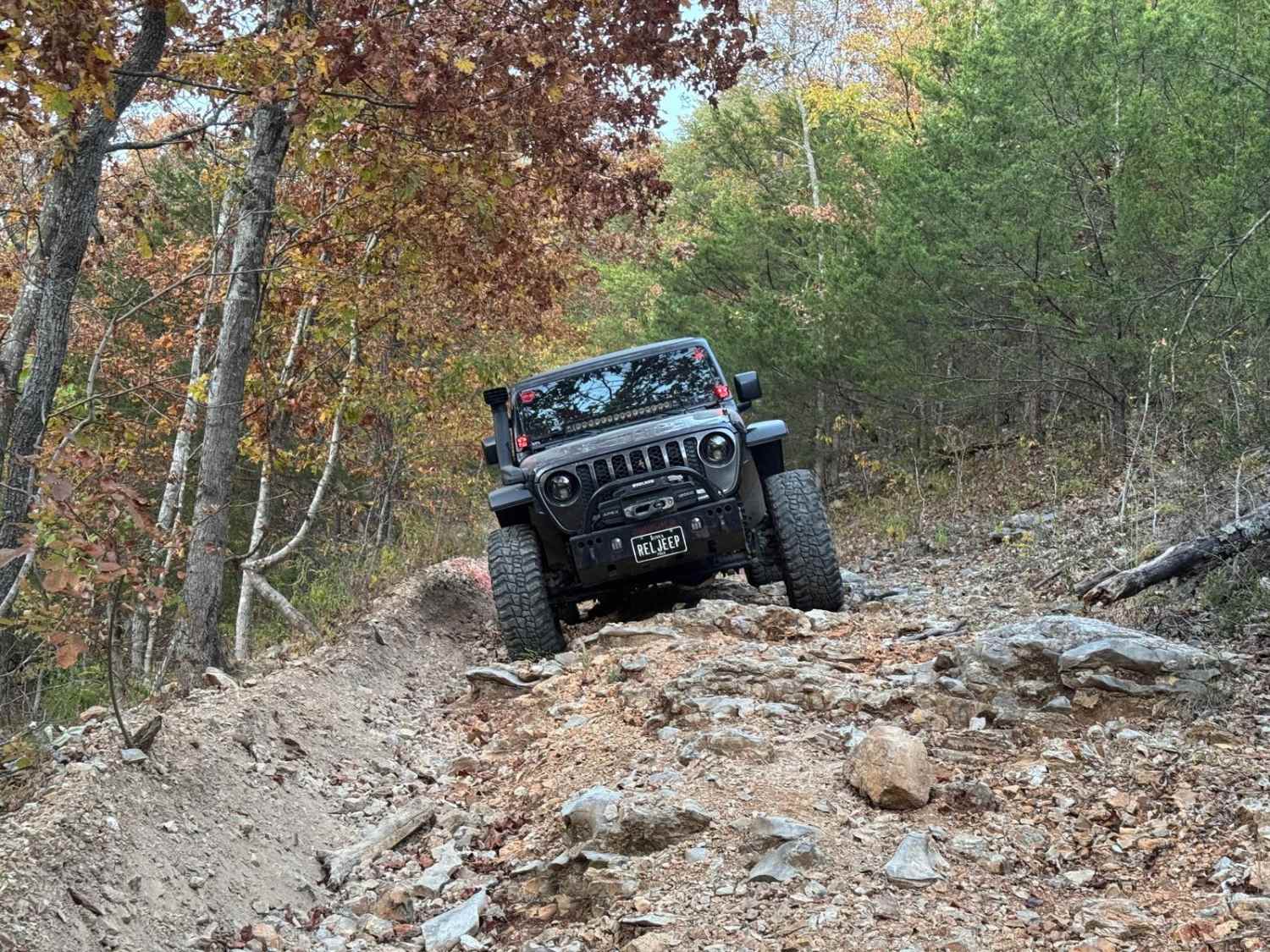
The onX Offroad Difference

onX Offroad combines trail photos, descriptions, difficulty ratings, width restrictions, seasonality, and more in a user-friendly interface. Available on all devices, with offline access and full compatibility with CarPlay and Android Auto. Discover what you’re missing today!