Top 5 E-Scouting Tips To Plan Your Backcountry Ski Adventure
How to find ski routes, assess snow quality before heading out the door, and get key info on avalanche hazards and snow safety right on your laptop or mobile phone.
The Best Day Out Starts With Having The Best Plan
Whether planning a dawn patrol jaunt, a day of deep powder turns, or a multi-day ski tour, onX Backcountry provides key planning tools to find new zones to ski, sniff out the best powder stashes, and navigate avalanche terrain safely. Our digital toolkit for backcountry skiing seamlessly combines thousands of ski lines featuring guidebook-quality route descriptions with the best conditions info from local SNOTEL data and Recent Satellite Imagery, as well as regional avalanche forecasts and slope angle analysis tools. Your best day out ski touring starts with having a dialed plan before setting out on the skin track, and onX Backcountry is your go to tool for planning.
1) Start Your Planning Process By Discovering New Guidebook Ski Lines – We Have Thousands In Our App
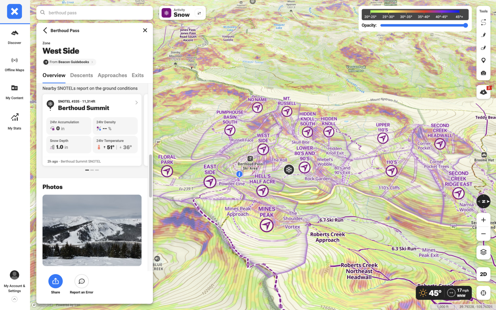
onX Backcountry has partnered with Beacon Guidebooks, leaders in backcountry ski guidebooks, to create a first of its kind digital experience which pairs their highly vetted ski lines with our set of critical avalanche safety and navigation information. Beacon Guidebooks has been on the leading edge of curating the best ski tour guides written by local experts across the country. This partnership represents our commitment to providing the best and most comprehensive ski route data available to our community.
Our current coverage includes guidebook content across:
- 26 Regions
- 282 Zones
- 1,805 Lines
Each guidebook in our app has a regional overview with detailed descriptions of zones and lines within that region, giving you tons of local insight. You can also easily see avalanche forecasts and recent SNOTEL data right in the app, as well as Avalanche Terrain Exposure Scale (ATES) ratings indicating terrain complexity. Hop in the app in Snow Mode and toggle into the Discover tab to find guidebook ski lines near you.
The current guidebook snow routes in the onX Backcountry app are:
- Marble
- Tahoe
- Taos and Santa Fe
- Mount Hood
- Shark Park
- Willams Peak
- Spring Creek Pass
- Wolf Creek Pass
- Sugar Bowls
- Van Horn Park
- Meadow Mountain
- Independence Pass
- Vail Pass
- Monarch Pass
- Ball Mountain
- Caribou
- Bald Mountain
- Hoosier Pass
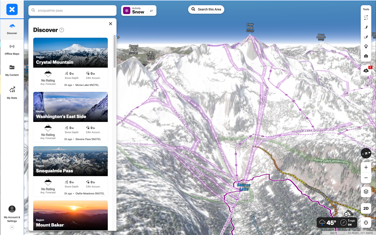
- Washington’s East Side
- Loveland Pass
- Berthoud Pass
- Snoqualmie Pass
- Buffalo Pass
- Mount Baker
- Crystal Mountain
- Olympic National Park
- Rocky Mountain National Park
- Cameron Pass
- Crested Butte
- Silverton
For more info on interacting with guidebook content in onX Backcountry, you can find more info here.
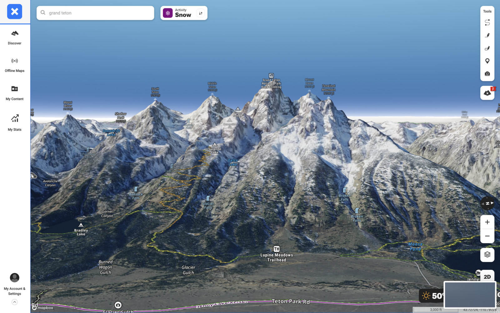
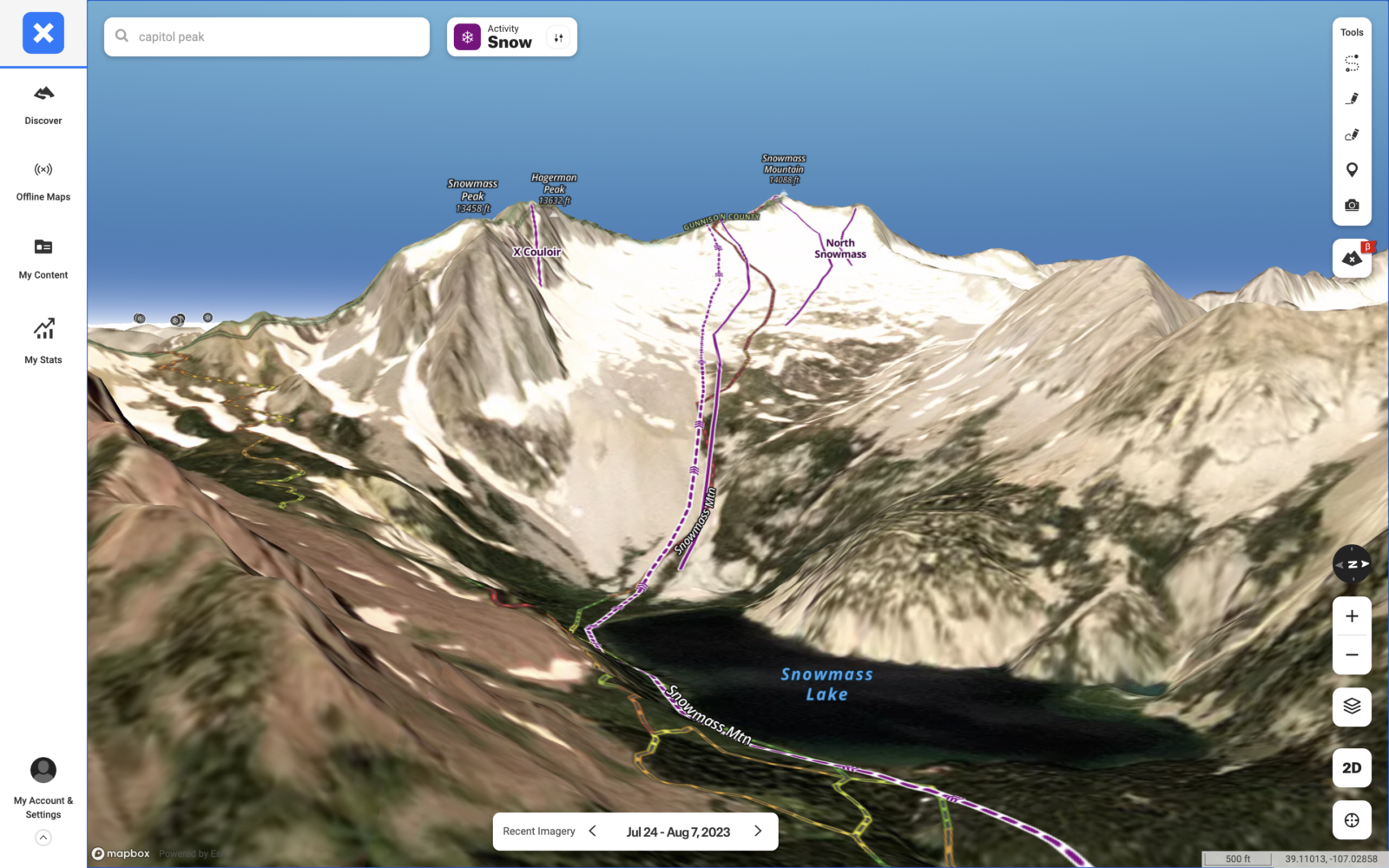
2) Take All Your Planning To The Next Level With 3D
Embracing the unparalleled utility of onX Backcountry’s 3D Map is pivotal for backcountry skiers seeking a safer and more immersive experience. This feature grants skiers an immersive, bird’s-eye view of the terrain, elevations, and intricate topography. By offering a three-dimensional perspective, it enhances route planning and enables skiers to comprehend the landscape’s nuances, such as cliffs, gullies, and ridges. Elevating your adventure, this 3D map layer transforms your mobile app and desktop webmap into an indispensable tool for precise e-scouting and allows you to understand ski zones both new and old on another level.
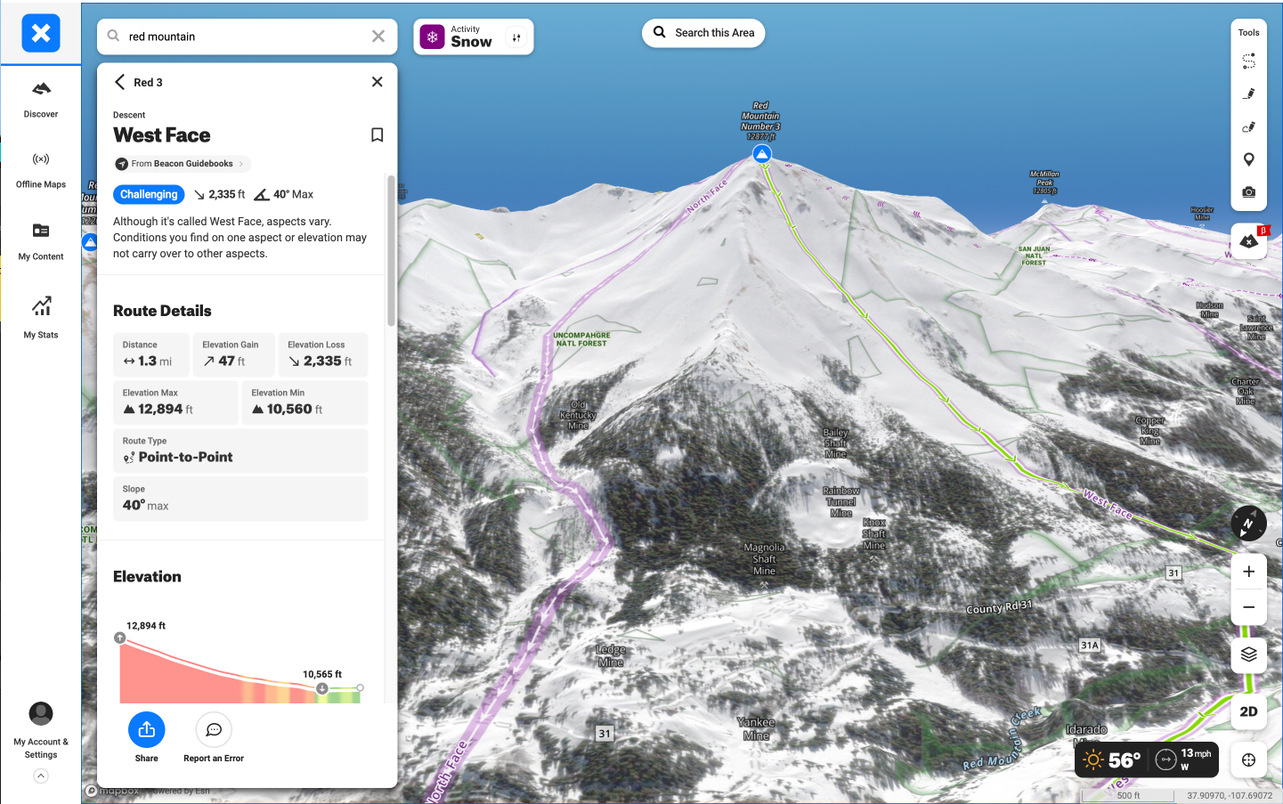
3) Break Down Avalanche Hazards With Slope Angle And ATES Ratings
Toggle on the Slope Angle Layer to find areas prone to avalanche activity to plan the safest route possible. Drop Waypoints along your potential route at safe locations where there will be a decision point and your group will need to stop, check in with one another, and assess the snowpack. Understanding as much as you can about the ski line before you head in will make you more prepared and give you a better understanding of when during the winter you might be able to ski that specific line. When the stars do align, you’ll have a rock solid plan with notes in onX Backcountry and you’ll be ready to get out there.
If you’re e-scouting a Beacon Guidebook ski line, doing your own assessment of the zone and looking at slope angles is just as important, but you’ll also have a helpful ATES rating of the Region, Zone, and Line right in the app. What is ATES? It’s a standardized system used in avalanche safety and forecasting to assess and communicate the level of avalanche risk and exposure in backcountry terrain. The ATES system categorizes terrain into various zones or classes based on factors like slope angle, terrain shape, elevation, and the potential consequences of an avalanche. Learn more about ATES maps and how ATES works here.
4) See Real-Time Conditions With Recent Imagery
Updated every 1 to 2 weeks, Recent Imagery allows Elite subscribers to see current conditions anywhere in the United States with unparalleled detail. Our recent imagery is twice as detailed as free sources (5 meters/pixel vs. 10 meters/pixel). As a skier, you can use this tool to determine whether a zone has enough snow to ski or whether a cornice is forming over your favorite line. To toggle on recent imagery on your mobile app, click into the layer selector tab in the bottom right corner of your screen, click Satellite or Hybrid Basemap, then click Preferred Basemap Imagery and select Recent Imagery.
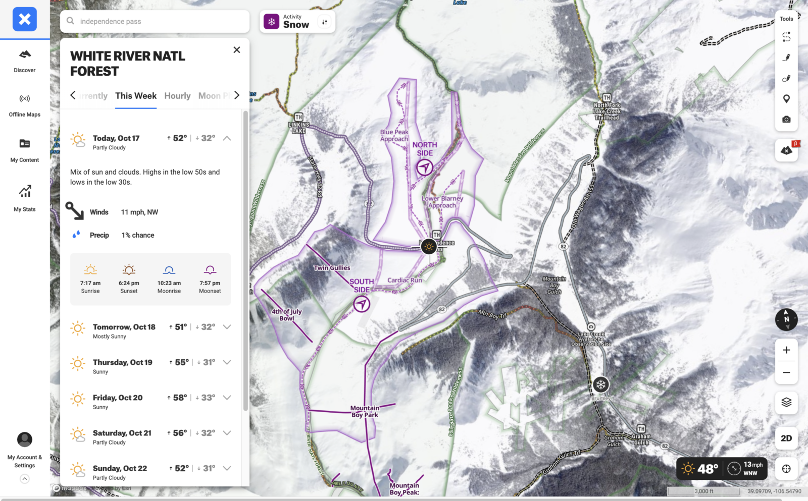
5) Get Avalanche Forecasts, Snowfall Data, And Weather Right At Your Fingertips
When the snow does start flying, onX Backcountry is your one stop shop for honing in on your ski plans to find the best snow in the safest areas each day. Right in the app, you’ll see the latest avalanche forecasts from every avalanche center in the U.S. and Canada. You can tap into each forecast zone for more detailed information and observations (if you’re not familiar with reading avalanche forecasts or are looking for a refresher, check out this helpful blog for more info).
You’ll also have the most up-to-date snow info in the palm of your hand with over 800 SNOTEL stations integrated right on your map showing you recent accumulation, temperature, and snow water equivalent. This info will help you know where it’s snowed recently and determine snow quality (will you be getting cold smoke, cream, or crust?).
Finally, you’ll also have real time wind and weather data right in your app. You can find this by tapping the weather icon in the upper right corner of your map, or tapping the map to pull a forecast for any point. We’ve tapped into Weather Underground’s network of 250,000 weather stations to ensure that you know you can count on the forecasts and current weather conditions you’ll find in onX Backcountry. You’ll be able to see current temperature, precipitation, pressure, sunrise / sunset times, as well hourly forecasts for that day and a seven-day forecast.
Pro tip: you can also set Wind Direction on your Waypoints, which will show you which way the wind is blowing and how hard it is blowing to help you determine if an area is getting scoured, filled in, or wind loaded. To toggle this on, drop a Waypoint and click on the Wind Direction button.