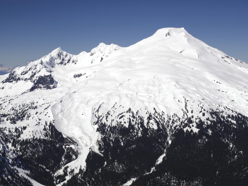
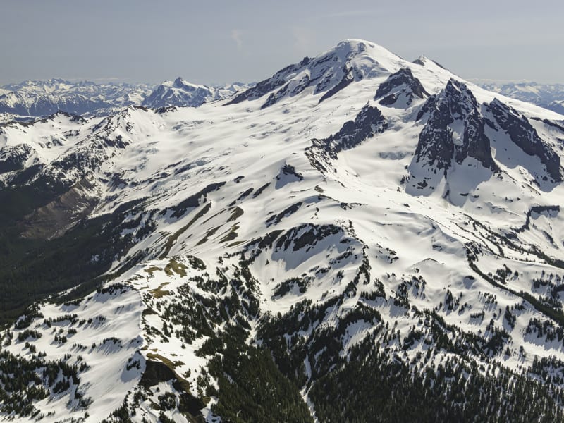
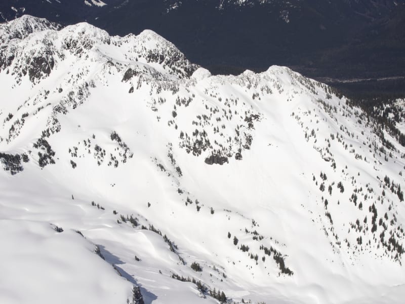
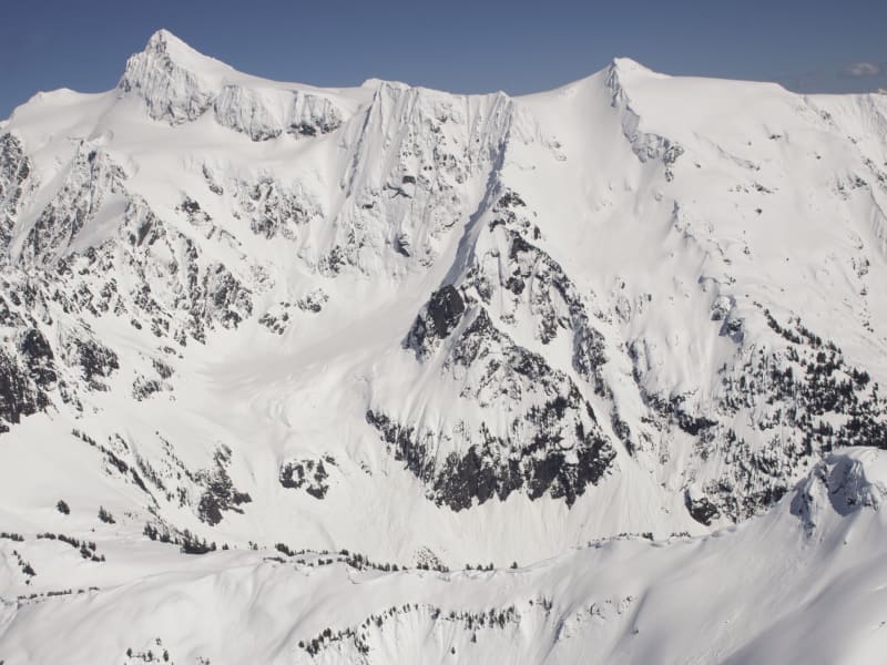
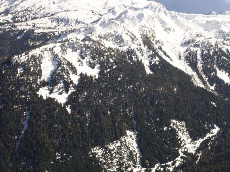
Mount Baker

Beacon Guidebooks has partnered with onX Backcountry. Find guidebook quality content for backcountry adventures in Mount Baker. Mount Baker has 24 zones to explore and 205 routes.

Total Zones
24

Publisher

Beacon Guidebooks

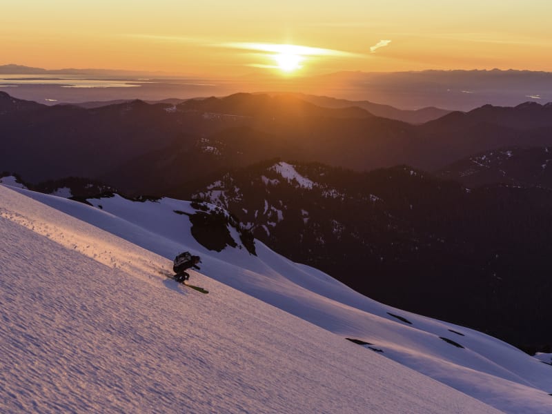
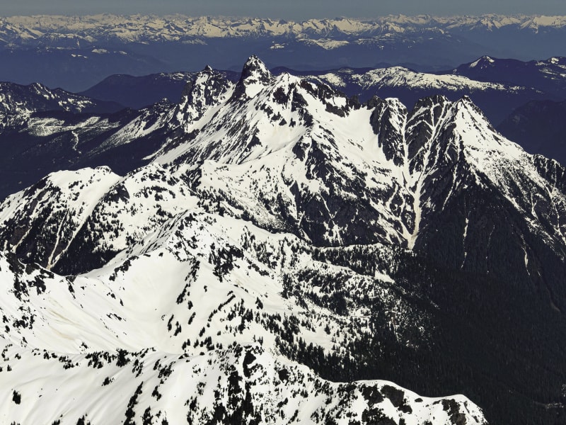
Mount Baker Overview

It has the deepest snowpack, super-accessible year-round touring, and a funky local scene that keeps the vibe family-friendly, community-focused and chill. Baker—originally called Kulshan—was renamed by George Vancouver during the first European passage into the Salish Sea in 1792. First climbed in 1865, the recreation evolved to powder skiing by 1927, and the ski area opened in 1929. Since its first ascent, Mount Baker’s abundance of year-round snow, vast glaciers, old-growth forests, and amazing river valleys has shaped this region into one of the premier outdoor playgrounds in North America. We followed up this second edition by circumnavigating the great Kulshan, flying north along the Mount Baker Highway, and scratched the surface of the Twin Sister Range. Our hard work added 49 new routes in 10 new zones. Additionally, we have added some new photos bringing in fresh perspectives and more detail, with help from our trusted local review board. What you get is a refined, beautiful, and reliable tool to help you dream and make better decisions this year and for years to come.

Zones Covered

Bagley Lakes
Routes
11
ATES Level
2
General Aspect
NW,N
Welcome to Baker! The world gathers here to get their first taste of legendary deep pow and easy access. The popularity and heavy use of this area, known as The Blueberry Chutes, does demand attention to where you skin and who is below you when dropping in. Respect the traffic and avoid skinning right up the runs (the dreaded Seattle Skintrack), even if avalanche hazard is low.
Routes
  • Bagley Lakes Approach
  • Cheap Date
  • 5 Minute Trees
  • 10 Minute Trees
  • Martha's
  • Blueberry Chute
  • Dog Chute
  • Gargoyle Prow
  • Newt's Chute
  • Little AK
  • Bagley Lakes Exit
Barometer Mountain
Routes
8
ATES Level
2
General Aspect
SE,S,SW,W,NW,N
Barometer gives you another opportunity to leave the Bagley masses behind with a 5–8 hour round trip over 9–14 miles. Use Pillow Fight or Iceberg to gain Galena Chain Lakes, then traverse and climb west to Barometer. All runs can end at the Silver Fir Campground at the bottom of the access road, where a car shuttle is recommended.
Routes
  • Barometer Mountain
  • Barometer Bowl
  • Polar Vortex
  • Weather Vein
  • Sweet Sweet Death
  • Baroclinic Zone
  • Barometer Mountain Exit
  • Barometer Mountain North Exit
Goat Mountain
Routes
6
ATES Level
3
General Aspect
S,W,NW,N
Like any goat rodeo, a high bar for entry gives way to believable riding. Survive the approach and refresh your pow in the Udders, a series of beautiful chutes that take you to the valley bottom, or harvest corn on the south side.
Routes
  • Goat Mountain Approach
  • South Face
  • Right Udder
  • Center Udder
  • Left Udder
  • Goat Mountain Exit
Herman Gulch
Routes
9
ATES Level
2
General Aspect
N,NE,E,SE
See how the other half rides on the Table side of Bagley Lakes. Enjoy the short approach across Bagley Lakes to explore the steep trees and chutes under Table. Pop over Herman Saddle, Mazama Bowl, or Mount Herman and be back in time for happy hour.
Routes
  • Herman Gulch Approach
  • Corner Pocket
  • Alaskan Amber
  • Diamond Trees
  • Slot Machine
  • The Grotto
  • Herman Saddle
  • Herman Gulch
  • Herman Gulch Exit
Herman + Stoneman
Routes
8
ATES Level
2
General Aspect
N,NE,E,SE,S,SW
So close, and yet so committing! To ride Stoneman, one must leave the familiar confines of Bagley Lakes into what feels like big mountain terrain. Whether approaching via Mazama or the top of the Boulderfield, expect to pause as you move into the steeper side of Mount Herman. Do your best to assess the conditions of your objective when it comes into view.
Routes
  • Herman + Stoneman Approach
  • East Gully
  • East Face
  • East Lodge Ridge
  • Herman North Face
  • Stoneman
  • Paradise Gully
  • Hermand + Stoneman Exit
Iceberg + Mazama
Routes
9
ATES Level
2
General Aspect
N,NE,E,SE,S,SW
Tour out to Herman Saddle and Mazama Dome and have your effort rewarded with sublime, full-frontal views of Shuksan and Kulshan, revealing their true vertical relief. This zone serves up short runs and grants access to much larger objectives off of Slate and Barometer, where 3,000’ of glades, chutes, and bowls await your tracks. Use Herman Gulch to approach.
Routes
  • Iceberg + Mazama Approach
  • Mazama Bowl
  • Pillow Fight
  • Secret Bowl
  • Osama
  • Iceberg Trees
  • Iceberg Bowl
  • WWIII
  • Iceberg + Mazama Exit
Mount Ann + Annette
Routes
6
ATES Level
3
General Aspect
NW,N
Deep in the Baker backcountry, this zone rewards fitness (you’re looking at 10 miles and 7–10 hours for the round trip) and requires low avalanche hazard, with fresh tracks for everybody! These lines are steep ski mountaineering objectives, so be prepared with your alpine kit.
Routes
  • Mount Ann + Annette Approach
  • Hidden Bowls South
  • Suspended Animation
  • Cryosphere
  • Pipe Dream
  • Mount Ann + Annette Exit
Mount Baker East
Routes
8
ATES Level
3
General Aspect
E
These are arguably the only fall-line runs you can ride off the Baker summit. The Classic Watson Traverse travels through this sector.The Boulder and Park Glaciers both offer long, intricate descents.These descents can also be linked up with an ascent of the Coleman-Deming Glaciers. Whiteout conditions can occur quickly on the mountain, and the route up or down can quickly be obscured; wands are necessary.
Routes
  • Mount Baker East Approach
  • Boulder Glacier Approach
  • Park Glacier
  • Boulder-Park Cleaver
  • Boulder Glacier
  • Sherman Peak - NE Face
  • The Portals
  • Mount Baker East Exit
Mount Baker North
Routes
8
ATES Level
3
General Aspect
NW,N,NE
As a member of the “50 Classics” club, Kulshan’s true “Nordwand” rises almost 3,000’ above the Coleman and Roosevelt Glaciers to provide one of the best proving grounds for aspiring ski alpinists to test their skills on steep faces and ridges.
Routes
  • Grouse Creek Approach
  • Mount Baker North Approach
  • Heliotrope Ridge Bowls
  • Coleman-Deming
  • Colfax NE
  • Roman Moustache
  • Coleman Headwall
  • Mount Baker Northwest Exit
Mount Baker North - Roosevelt Glacier
Routes
9
ATES Level
3
General Aspect
NW,N,NE
This is the second half of the Kulshan “Nordwand”—the terrain from the Roosevelt Glacier to the Cockscomb. This sector contains very complex features with eroding glaciers and steep ridges, making every descent a no-fall zone.
Routes
  • Mount Baker North - Roosevelt Glacier Approach
  • North Ridge
  • Roosevelt Headwall
  • Cockscomb
  • Bastile Ridge
  • Hadley Peak West
  • Hadley Peak North
  • Chowder Ridge
  • Mount Baker North - Roosevelt Glacier Exit
Mount Baker South
Routes
14
ATES Level
2
General Aspect
ALL
Brrrraaaaap! This National Recreation Area might be the most inclusive alpine zone: it welcomes snowmobiles, snowshoes, skis, snowboards, and crampons. Parking is tricky, with sleds and trailers competing for space. It is common to drop off a sled, then park one’s truck/trailer pointing back down. Share the road with courtesy and common sense. Sleds must slow down near foot traffic and give them time to move over.
Routes
  • Mount Baker South Approach via Easton Glacier
  • Mount Baker South Approach via Scott Paul
  • PB Lookout Face
  • Mazama Park Trees
  • Railroad Grade
  • Easton Halfpipe
  • Easton Glacier
  • Colfax South Face
  • Sherman Peak -Talum Glacier
  • Sherman Peak - South Shoulder
  • Squak Glacier
  • Crag View Bowls
  • Mount Baker South Exit
  • Mazama Park Exit
Mount Baker West
Routes
6
ATES Level
3
General Aspect
SW,W,NW
Thunder across the west side of Baker. Between Heliotrope and the Railroad Grade exists a glacier basin that requires just enough commitment to climb back over what you ride with the quality of great, steep fall-line runs to be worthy of your time.
Routes
  • Mount Baker West Approach
  • Mount Baker West Approach to Couloir X
  • Thunder Glacier
  • Couloir X
  • Point 8400 South Face
  • Mount Baker West Exit
Mount Herman
Routes
8
ATES Level
2
General Aspect
E,SE,S,SW,W
Mount Herman looms over the Baker Ski Area parking lot, taunting you with possibilities close to the road. Once you swing into Bagley Lakes, the Boulderfield or Herman Gulch will lead you to the many roadside attractions of Herman.
Routes
  • Secret Bowl
  • Mount Herman Approach East
  • Mount Herman Approach West
  • Little Switzerland
  • Corona Bowl
  • Rampzilla
  • The Boulderfield
  • Enchanted Forest
Ptarmigan Ridge
Routes
11
ATES Level
3
General Aspect
W,NW,N,NE,SE
Big lungs get you big runs. There’s so much open terrain available once you’ve toured into Ptarmigan Pass (3.5 miles and 1.5–2.5 hours one-way). Summiting Baker from here takes another day.
Routes
  • Ptarmigan Ridge Approach
  • Northeast Face
  • Chugach Impersonator
  • Solar Scape
  • Heli Run
  • Soapy
  • Baker Horn
  • Coleman Pinnacle
  • Gatekeeper
  • Lasiocarpa
  • Ptarmigan Ridge Northside Exit
Ruth + Icy
Routes
6
ATES Level
2
General Aspect
S,W,NW,N
Dear Ruth: You are my favorite run—so open and smooth.You have the best views (and the easiest summit). It’s hard to exaggerate how much fun a day on Ruth can be. If you need a challenge, tag Icy or link up with Shuksan via the Nooksack Traverse.
Routes
  • Ruth + Icy Approach
  • Hannegan Peak
  • Ruth Mountain
  • Icy Peak
  • Nooksack Traverse
  • Ruth + Icy Exit
Shuksan Arm
Routes
10
ATES Level
3
General Aspect
N,NE
The Hollywood Zone of the Cascades: so much great footage draws us in; so many massive avalanches make us cautious. Many inbounds riders bootpack from the top of Chair 8, so expect lots of traffic if you are skinning in from Austin Pass.
Routes
  • Shuksan Arm Approach - Austin Pass
  • Shuksan Arm Approach - Chair 8 Bootpack
  • The Beast
  • Hollywood Ridge
  • Hoy!
  • Pyramid
  • Safety Line
  • The Hourglass
  • Hidden Bowl
  • Shuksan Arm Exit
Shuksan North
Routes
11
ATES Level
3
General Aspect
W,NW,N
Le Ski Extreme! Without a doubt the best, most accessible big alpine lines in the Lower 48—3,000’ of 40º+ glaciated features await your descent. Be prepared, as each tour described here requires no less than 9–10 hours and a full alpine climbing kit. Many of these lines were pioneered within the last 15 years by Dan Helmstadter. It’s widely thought that Helmstadter has likely doubled the known lines on the ski area side of Mount Shuksan—all solo.
Routes
  • Shuksan North Approach
  • White Salmon Glacier
  • White Salmon Headwall
  • Hanging Glacier Headwall
  • Hanging Glacier
  • NW Couloir
  • North Buttress Couloir
  • North Buttress Connection
  • North Face
  • North Face West
  • Shuksan North Exit
Shuksan South
Routes
6
ATES Level
3
General Aspect
E,SE,S,SW
Welcome to the kinder, gentler side of “Thunder Mountain.” Beautiful old growth gives way to one of the best introductions to alpine touring.The Sulphide Glacier offers fun rolling terrain.The most technical riding is through the trees at the bottom.
Routes
  • Shuksan South Approach
  • Shannon Ridge
  • Sulphide Glacier
  • Crystal Glacier
  • Summit Pyramid
  • Shuksan South Exit
Shuksan West
Routes
8
ATES Level
3
General Aspect
NW,N,NE
Shuksan sits at the end of the Shuksan Arm, looming above the White Salmon Lodge. This is a high alpine zone that demands all the equipment and skills to safely navigate steep, glacial terrain with rock features. All tours in this zone are a big commitment. Plan on a 9+ hour day for fit athletes. Various ways to get here means you need to map out your route and mileage and plan accordingly.
Routes
  • Shuksan West Approach
  • Curtis Glacier North
  • Curtis Glacier Center
  • Curtis Glacier South
  • Curtis Glacier Headwall
  • Southwest Left
  • Southwest Right
  • Shuksan West Exit
Slate Mountain
Routes
9
ATES Level
2
General Aspect
NW,N,NE
So many good lines (and so many good puns) waiting for you. Put in the effort to access and sample the goods. Slate offers some of the longest lines in this zone, going all the way down to Silver Fir Campground at the bottom of the access road.The price for amazing vertical is fitness—these tours range from 8–14 miles, which can mean 7–10 hours. Leaving a car shuttle at Silver Fir Campground is recommended, as is waiting for a deep snowpack at lower elevations. Otherwise, skin back up to the parking lot behind the Mount Baker Lodge.
Routes
  • Slate Mountain Approach
  • Master Slater
  • Open Slate
  • Cheapslate Bowl
  • Gulliver's Gully
  • Pixies and Pom Poms
  • Clean Slate Couloir
  • Slate Mountain East Exit
  • Slate Mountain North Exit
Swift Creek
Routes
9
ATES Level
2
General Aspect
NE,E,SE,S,SW
This zone offers a range of terrain suitable for beginners and for touring on days with higher avalanche hazard. It also holds terrain with long, steep lines dropping into the deep backcountry. All runs return via Swift Creek except Guido’s Glades, which drops south from Artist Point, where you can extend your tour and access Ptarmigan Ridge or climb back up to Artist Point to stay close to the trailhead.
Routes
  • Swift Creek Approach
  • Swift Gully
  • Swift Creek South Face
  • Swift Creek SE Face
  • Huntoon Run
  • Guido's Glades
  • Huntoon NE Face
  • Huntoon East Face
  • Swift Creek Exit
Table - SW Face
Routes
12
ATES Level
2
General Aspect
N,NE,E,SE,S
Enter the land of giants, where Baker and Shuksan are closer and the runs are bigger.This zone requires commitment as you drop into more distant drainages—and some of the best open powder.This is where you cut the Bagley Lake umbilical cord.
Routes
  • Table - SW Face from Ptarmigan
  • Why Not?
  • Lost World
  • Pond Shot
  • Back Pocket
  • Bonsai Trees
  • Sesame Street
  • Mission Impossible
  • Hush Hush
  • Ptarmigan Chute
  • Ptarmigan Bowl
  • Table - SW Face Exit
Twin Sisters Range
Routes
8
ATES Level
3
General Aspect
ALL
According to Lummi legend, The Twins, along with Shuksan, were the three children of Kulshan (Baker) and Duh-hwahk (Rainier). Geologists identified the Twin Sisters Range as the largest body of exposed Olivine (magnesium iron silicate—over three billion years old) in the Western Hemisphere. A fragment of the Subcontinental Mantle pushed to the surface like a watermelon seed, creating an amazing alpine playground with intriguing ski tours and epically long ridge climbs.
Routes
  • Twin Sisters Range Approach
  • Elbow Lake Approach
  • North Twin North Face
  • North Twin SW Couloir
  • South Twin NE Face
  • South Twin SW Face
  • Cinderella Peak - North Face
  • Twin Sisters Range Exit
Winchester + Larrabee
Routes
6
ATES Level
3
General Aspect
SE,S,SW
The Winchester Zone is like Fight Club—if you have to talk about it... The Winchester Fire Lookout has provided a legendary launch pad for adventures to the bigger lines on Larrabee and the Pleiades, as well as longer missions to American and Canadian Border Peaks and Tomyhoi.
Routes
  • Winchester + Larrabee Approach
  • Larrabee SW
  • Larrabee South Couloir
  • Larrabee SE
  • Pleiades South Couloir 1&2
  • Larrabee South Exit