
Find Mountain Bike Trails with onX Backcountry
Before your next mountain biking adventure, harness the power of onX Backcountry, the ultimate mountain biking trail mapping app, to plan your next ride. With detailed trail maps and a wealth of comprehensive features, onX Backcountry can guide you to your next favorite biking destination.
Explore Trail Mode for Mountain Biking
Below is an interactive 3D map featuring mountain bike trails in Crested Butte with our Mountain Biking activity mode toggled on. This layer assists you in assessing trail challenges and planning your ride. Use Control + Drag to rotate, tilt, and pan. Login or create an account to access full functionality and explore areas near you.
Login or create an account to gain full functionality and find areas like this near you..
How to Use onX Backcountry for Mountain Biking
Learn how to make the most of onX Backcountry for your next mountain biking adventure. This comprehensive video tutorial will demonstrate how to utilize every feature of the app effectively.

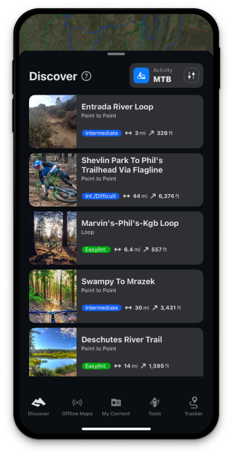
Discover Thousands of Mountain Biking Adventures
onX Backcountry has integrated mountain biking trails from various sources to provide detailed information and route finding to popular biking trails. Explore them on our interactive 3D maps for seamless route planning.
Assess Trail Difficulty
Determine the challenge level of your biking trails with onX Backcountry. Gain insights into the technicality of the trail, what gear you’ll need, and anything else you need to know to plan your ride.

Plan Your Ride
Utilize onX Backcountry’s trail mapping capabilities to plan your mountain bike ride. Use route builder to plan your custom route, calculate distances, and elevation changes for the perfect mountain bike adventure.

Check the weather forecast
With onX Backcountry’s weather tools, you can optimize your mountain biking adventure by staying informed about current and forecasted weather conditions. Plan your route with confidence, knowing you have access to accurate weather data to guide your ride.

Never Lose Your Way, Even Off the Grid
With onX Backcountry’s offline maps, you can navigate confidently to your biking destinations, even when you’re off the grid. Access maps and trail details without needing an internet connection, providing peace of mind and enhancing your biking experience.
Know Where You Stand: Access Private and Public Land Data
With onX Backcountry’s detailed private and public land data, you’ll have the knowledge you need to navigate biking areas ethically and legally. Understand land ownership boundaries and access regulations to ensure you’re riding in the right place, at the right time.
Other Uses for onX Backcountry


Before your next mountain bike outing, use onX Backcountry, the best MTB trail map app, to help you plan your next adventure.