Olympic National Park

Beacon Guidebooks has partnered with onX Backcountry. Find guidebook quality content for backcountry adventures in Olympic National Park. Olympic National Park has 22 zones to explore and 163 routes.

Total Zones
22

Publisher

Beacon Guidebooks

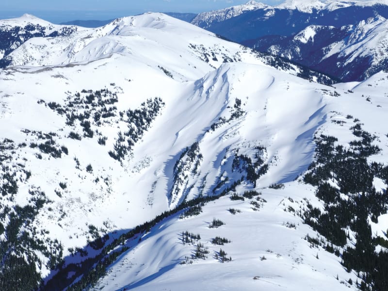
Olympic National Park Overview

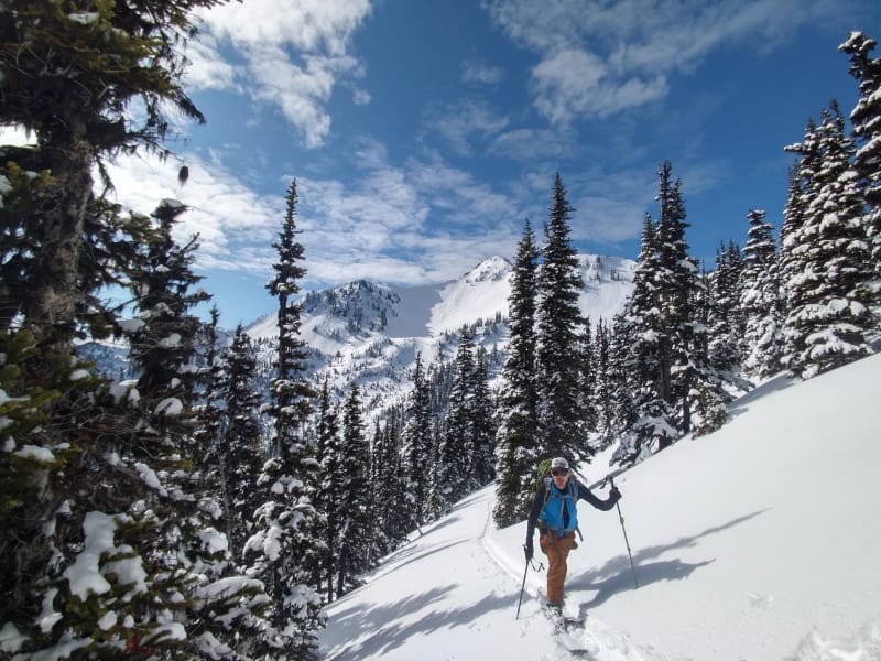
The Duwamish of the Salish sea call them 'Sun-a-do', and the ancestors of the Klallam have been living, hunting and gathering in the high mountains since time immemorial. The Spanish sailed along the coast in 1774 and named the highest peak, Cero Nevado de Santa Rosalia. In 1788, the British Explorer Roger Meares renamed the highest peak, Mt Olympus, because it looked like the 'abode of the gods', and just like that the Olympic Mountains became part of the European map. The 1890's saw climbers begin ascending the summits of Mt. Olympus, with the main summit finally being climbed in 1907. Deer Park became Washington's premier ski area in the mid 1930's. The Hurricane Ridge road was built in the early 50's and the ski area moved from Deer Park, establishing a new winter recreation center for the Olympic National Park. Ski touring began along the roads of Deer Park and Hurricane Ridge and shifted to the Bailey Range and the higher peaks in the 1990's. My first tour on Hurricane Ridge was the Mt Angeles Circumnav with my friend to research the tour for a book he was working on. Standing on the summit, I saw Baker and the Coast Range; my jaw dropped. When NWAC offered me a position as one of the professional observers assigned to the Olympics, they asked if I would mind the drive, I laughed. I said I would be happy to make the commute because I knew how good the touring was and how beautiful the sunrise was over the Salish Sea on the ferry. A true 'sea to sky road', the Hurricane Ridge Road was a visionary project by Olympic National Park to give all people access to the alpine and one of the most sublime mountain vistas on the planet. Every day I went to work with the Rangers of Hurricane Ridge was a chance to touch the sky, to witness where weather meets land and earns its name. Winds pick up faster than a Porsche, snow flies in, building cornices like an alien invasion. Cold clear nights bust the 'Myth of the Maritime Snowpack' as I have tracked persistent slabs across the range year after year when it was supposed to be stable and homogenous just like the Cascades. Learning the personality of the snow. the mountains, and the community who live and play here, continues to fill me with wonder and respect.

Zones Covered

Angeles West + Super Bowl
Routes
11
ATES Level
2
General Aspect
W,NW,N
The softer side of Mt Angeles offers long, gladed runs into multiple bowls with simple and challenging terrain. Runs starting from the King Dome leading into Super Bowl and Lost Bowl are a gift of low exposure well suited for storm riding. Runs from the West Bench and the northside of Lost Bowl step up the terrain.
Routes
  • Mile 15 Approach
  • Matchstick Trees
  • Sex and Junkfood
  • Southwest Glades
  • Silverback
  • Super Bowl
  • Engagement
  • Sunday Chutes
  • Top Banana
  • Outback Exit
  • Superbowl Exit
Darkside
Routes
9
ATES Level
3
General Aspect
NW
The northside of Mount Angeles drops you down deep and steep runs that feel like the darkside of the Moon! A commiting zone that rewards the skilled and patient skier. Most runs accessed from Silver Fir and exiting via Klahhane Bowl and Victor Pass Trees.
Routes
  • Mile 15 Approach
  • Outback Exit
  • Outback
  • Tranquility Bowl
  • Van Allen
  • Aldrin
  • Armstrong
  • Moonwalk
  • Darkside Exit
Deer Park North
Routes
5
ATES Level
2
General Aspect
N,NE,E
The Deer Park ski area of the late 30s through the early 50s never operated on this side of Blue Mountain. But, it is likely that intrepid skiers from that time first explored this steep and shady side of the Deer Park area. The bowls and runs here add a little more wildness to an already remote winter area.
Routes
  • Deer Park Approach/Exit
  • Deer Park Exit
  • Cornice Line
  • Back Bowl
  • Back Bowl Exit
Deer Park South
Routes
5
ATES Level
1
General Aspect
S,SW,W
In 1936, Deer Park opened to skiing and in 1939 was advertised as " The finest ski hill in Washington". Several rope tows, a ski jump and a day lodge were operated here until the ski operation moved to Hurricane Ridge in 1958. Located farther east and in the rain shadow of the Olympics means that the snowpack is considerably thinner here, but if you are keeping track of storm paths or want a remote day in the hills with a long but easy access, Deer Park can provide some really nice skiing. The seasonally closed road keeps most people from visiting during the winter, aside from the occasional skiier or snowshoer. There are good places to camp abound at Deer Park. This was the original starting point for the Deer Park to Hurricane Ridge ski traverse. The first traverse on record in the Olympics took place in 1937.
Routes
  • Deer Park Approach/Exit
  • Exit Trees
  • Road Run
  • Old Ski Hill
  • Deer Park Exit
Eagle Point North
Routes
11
ATES Level
2
General Aspect
N,NE,E
Eagle Point days are long but very rewarding. The area also has many nice spots to camp, and a weekend at Eagle Point can be a great way to explore the zone. Heading to the NE side of Eagle Point, runs like Seahawk or Harpy have a lengthy exit, and getting back to the summit directly will likely involve booting / ridge scrambling.
Routes
  • Obstruction Road Approach
  • Eagle Crest Approach
  • Eagle Exit
  • Wild Eagle
  • Harpy
  • Seahawk
  • Southern Eagle
  • Resort Run
  • Resort Run Exit
  • Southern Eagle Exit
  • Wild Eagle Exit
Eagle Point + PJ
Routes
13
ATES Level
2
General Aspect
W,NW,N
This is the farthest a party can reasonably reach in a day and still make it back to your car by closing time, but you gotta move fast. The area also has many nice areas to camp, and a weekend at Eagle Point can be a great way to explore the zone. Skiing all the way down to PJ Lake should be avoided, except on the deepest of years. Very thick vegetation and a cliff band surround the southeast through west sides of the lake. 2.5-3hr approach and return.
Routes
  • Obstruction Road Approach
  • Eagle Crest Approach
  • PJ Bowl
  • PJ Gully
  • Eagle Glades
  • Bald
  • Golden
  • Double Chute
  • Eddie's
  • Sam The Eagle
  • Eaglet
  • Eyrie
  • Eagle Exit
Elk Mountain
Routes
9
ATES Level
3
General Aspect
NW,N,NE
The amazing terrain of Psycho Chutes and Elk Mountain jump out as you travel up the HR road. However, getting there is quite an undertaking, with a full day required just to access for most groups. Most often skied in the spring or during a Deer Park traverse. The opportunity to access these slopes in stable winter powder is a rare and special experience.
Routes
  • Obstruction Road Approach
  • Obstruction to Elk
  • Elk Bowl
  • Psycho/Elk Exit
  • Hannibal
  • Bates Motel
  • Annie Wilkes
  • Psycho
  • Jack the Ripper
Hurricane Hill North
Routes
7
ATES Level
2
General Aspect
N
The bigger, gnarlier, more commiting aspect of Hurricane Hill. Narrower and steeper features add a higher level of commitment and reward you with first tracks.
Routes
  • Hurricane Hill Approach
  • Little River Bowl
  • Burn Bowl
  • Central Bowl
  • North Bowl
  • Central Bowl Exit
  • Little River/Burn Bowl Exit
Hurricane Hill South
Routes
10
ATES Level
2
General Aspect
N,NE,E
Up ahead in the distance, I saw a shimmering light.... Not the Eagles, but it feels like you are trying to get to Hotel California. The pleasure of mellow meadow skipping is guarded by an almost flat 3.2 mile approach that feels uphill both ways. Once you are there, open bowls and faces await.
Routes
  • Hurricane Hill Approach
  • Black Forest
  • Meadow Skipper
  • Triple Fall Line
  • Spring Line
  • Hurricane Hill Bowl
  • Hurricane Hill Glades
  • Black Forest Exit
  • Spring Line Exit
  • Triple Fall Line Exit
Klahhane Ridge
Routes
12
ATES Level
3
General Aspect
NW,N,NE,E
One of the best Chuting Galleries in the Northwest! A stunning north-facing high alpine cirque, with gorgeous views of the Strait of Juan de Fuca.
Routes
  • Switchbacks Approach
  • Bits & Bobs
  • Dealer's Choice
  • Holding Cards
  • Ace
  • Holy Roller
  • Shuffle
  • All In
  • Cliff Shot
  • Klahhane Bowl
  • Heather Pass
  • Klahhane Exit
Lillian through Moose
Routes
14
ATES Level
3
General Aspect
ALL
A string of alpine pearls. These wide-open and above treeline gems offer numerous options and enough skiing for endless fresh tracks. A traverse of the bowls is an excellent day as you work south to north. Each uptrack takes you to the top of your next glorious run. This area requires an overnight trip to access.
Routes
  • Lil' Otter Approach
  • Moose Peak Approach
  • Lil' Otter Bowl
  • Badger Bowl
  • Wolverine
  • Goat Rodeo
  • Bowl Winkle
  • Northern Exposure
  • Mighty Moose Bowl
  • Badger Bowl Exit
  • Bowl Winkle Exit
  • Goat Exit
  • Moose Bowl Exit
  • Moose Peak Exit
Maggie's + 20th of June
Routes
12
ATES Level
2
General Aspect
NE,E,SE,S
Roadside touring at its finest! Maggie’s offers beginners one of the safest uptracks with a variety of glades, bowls and a few fun chutes which round out this 5-star gem for all levels. 20th of June adds an element of history (a D3+ Avalanche Path that slid on the...20th of June) and spice with its frequent avalanches often breaking down to the ground! In other words, it may look mellow, but be on your guard.
Routes
  • 20th of June Approach
  • Maggie's Approach
  • Sunset
  • Doug's Delight
  • Maggie's Face
  • Wrinkles
  • Maggie's Nose
  • 20th of June
  • Bowling Alley
  • Gutter Glades
  • Sunscreen Please
  • East Alley
Mustang Bowl + North Bowl
Routes
10
ATES Level
2
General Aspect
NW,N
Steeper and deeper. The flowy open trees of Maggie’s Backside are bounded on both sides by the steeper terrain of Mustang and North Bowl. Being on the lee side of the ridge means the snow piles deep and produces many wind features. Large and thick cornices commonly crown much of the ridgeline here. Linking any of these runs back to a Maggie's descent make for a great short tour.
Routes
  • 20th of June Approach
  • Maggie's Approach
  • Mustang Glades
  • Plumb Line
  • Wind Shot
  • Nordic Nose
  • Maggie's Backside
  • North Bowl
  • Backside Exit
  • Mustang Exit
Obstruction Peak
Routes
7
ATES Level
2
General Aspect
W,NW
The end of the road! Could be a great country song, ‘Take me to, Obstruction Road, the place where..’ the wild riding opens up in a series of amazing, alpine bowls with runs in every direction! The commitment requires an overnight, well worth hauling your camping gear. 6-8 hrs to travel to Obstruction Point. On the Deer Park traverse, Obstruction Point is a transition point and the main obstacle for the tour. Coming from the HR road, beyond here you are in wild country till Deer Park. And from Deer Park you have made it back to a road!
Routes
  • Obstruction Road Approach
  • Obstruction to Elk
  • Detour
  • Obstruction Peak
  • Elk Bowl
  • Psycho/Elk Exit
  • Obstruction Exit
Roadside
Routes
7
ATES Level
2
General Aspect
E,SE,S
Klahhane Ridge is the gift that keeps on giving, with long fall line runs, nicely gladed trees, fun terrain features and close to 2,000ft of vertical that drops you straight onto the road! If you’re short on time to get back to your car from Victor Pass before the road closes, ski Victor Pass Trees and not any of the other runs described.
Routes
  • Switchbacks Approach
  • Victor Pass Trees
  • Hang Ten
  • Riptide
  • Jaws
  • Maverick's
  • Klahhane Beach Club
Rocky Peak
Routes
6
ATES Level
3
General Aspect
NW,N,NE
Like the Movie, Rocky Peak feels old school, tough to get to know but once you earn the knowledge you feel like ‘The Champ!’ Complex terrain gives way to long, steep runs into alpine bowls and chutes which you may not need to share. A short rope (30m) and some anchor material is recommended for easy descent of the rock steps.
Routes
  • Rocky Peak Approach
  • Balboa
  • Ivan
  • Apollo
  • Dragon Tooth
  • Rocky Peak Exit
Silver Fir + Mt. Angeles South
Routes
8
ATES Level
2
General Aspect
SE,S,SW
The lighter side Mount Angeles. Seductive glades perched below steep alpine terrain with a variety of secret passages. This zone provides many options from mellow to extreme and for storm days to stable spring corn.
Routes
  • Mile 15 Approach
  • Ethan Alleys
  • Silver Fir
  • Off-Line Trees
  • The Ramp
  • Pipeline
  • Angeles Main Chute
  • East Summit
Ski Area
Routes
6
ATES Level
2
General Aspect
NW,N,NE
One of the great legacies in our ski history, and one of only three remaining ski operations in a National Park. The Hurricane Ridge Ski Area has been running since 1958, after being relocated from Deer Park. Three surface lifts cover ten runs, all of which are for ski area ticket-holders only. The tours into neighboring North Bowl, Idaho Bowl, and Sunrise are fun. Backcountry skiers should avoid skiing in this zone when the Ski Area is in operation.
Routes
  • Far Face
  • Avalanche Face
  • Near Face + Cabin Ledges
  • Idaho Bowl
  • Snag Buttress
  • Lodge Run
Steeple Rock Burn
Routes
8
ATES Level
2
General Aspect
N,NE,E
The 2016 Cox Valley fire cleared out a lot of terrain here and when the snow gets deep, the forest pillows are plentiful. Careful understanding of how far you descend will help make a successful tour on this aspect. The last pitch into the bottom of Cox Valley can be skied but it is difficult to get out of. The brush is thick and the terrain quality is marginal.
Routes
  • Obstruction Road Approach
  • Steeple Summit Approach
  • Bishop
  • Priest
  • Heretic
  • Nave Glades
  • Sunday School
  • Steeple Exit
Steeple Rock North
Routes
5
ATES Level
2
General Aspect
N
First stop along Obstruction Point road, Steeple Rock offers fine glade skiing on its northern side, steep chutes from its summit, and great views back to Mount Angeles. The 2016 Cox Valley fire cleared out a lot of terrain here and when the snow gets deep the forest pillows are plentiful. The last pitch into the bottom of Cox Valley can be skied, but it is difficult to get out of. The brush is thick and the terrain quality is marginal.
Routes
  • Obstruction Road Approach
  • Steeple Summit Approach
  • Apostate Forest
  • The Belfry
  • Bench Exit
Sunrise + Cox
Routes
5
ATES Level
2
General Aspect
N,NE,E
Above or below the road is the question of this zone. The Sunrise Bowl area is some of the most heavily skied terrain at the ridge with rope tow access on the backside and car shuttle options for maximum laps. While below the road the trees of Cox Valley offer nice storm riding options and tend to keep cold snow.
Routes
  • Sunrise Bowl
  • Spiny Pillows
  • Cox Trees
  • 5066
  • Cox Valley Exit
Visitor Center
Routes
3
ATES Level
2
General Aspect
SE,S,SW
That big, open, sweeping south face below the Visitor Center entices skiers and photographers alike. The siren song is often cut short by gale force wind blowing you back to your car. When the sun is out, the corn can be perfect. Just be aware that the whole slope is a giant convexity that rolls into a steep band of trees and treacherous gullies.
Routes
  • Front Porch
  • Staircase Trees
  • Toilet Bowl