onX Backcountry Features
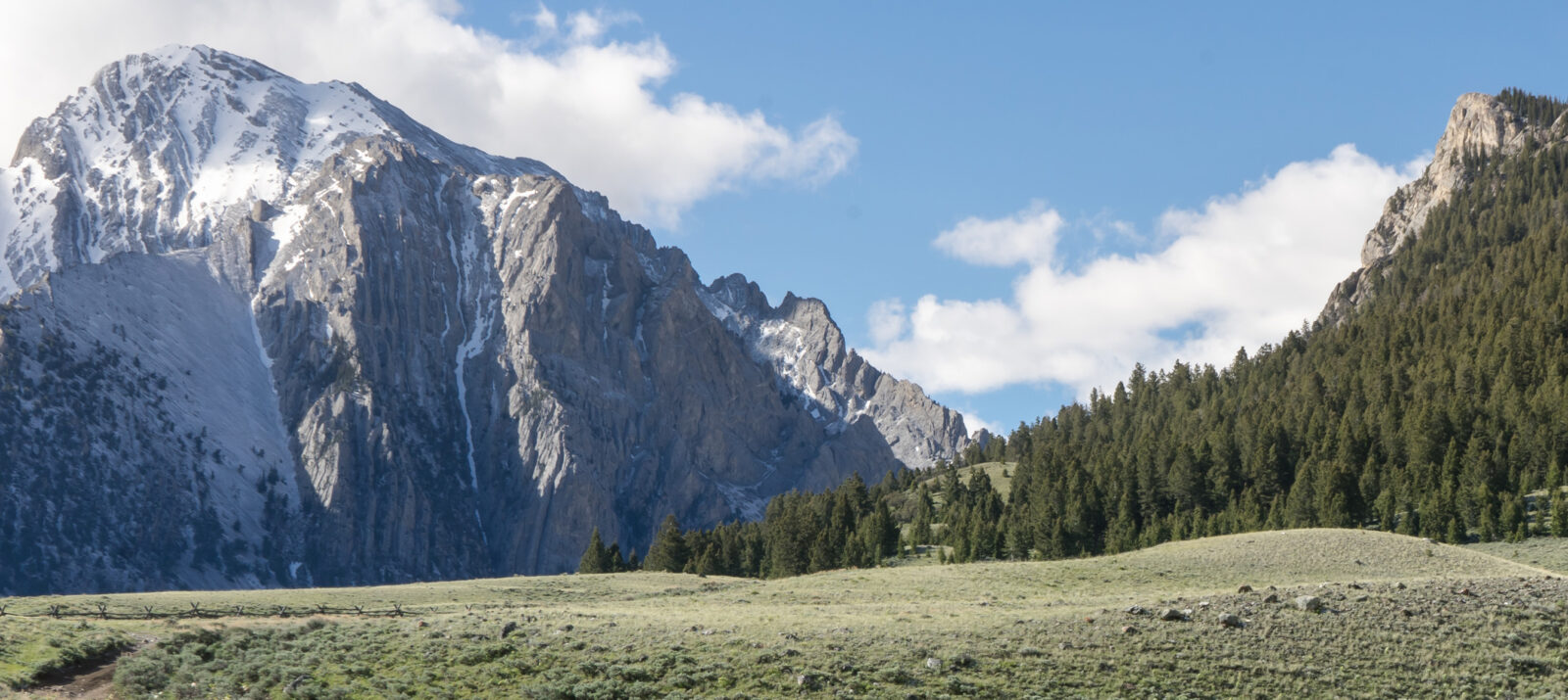
onX Backcountry provides the information you need to plan that next hike, ski, or adventure all in one place. Whether you’re discovering a new dream line in the backcountry or planning a multi day backpacking trip, onX Backcountry can give you the confidence to get up, get out, and get back home safely. Learn more about what onX Backcountry can do for you.

Everything You Need in One Place
onX Backcountry puts all of the information you need to plan your next adventure in one App. onX Backcountry provides essential information on trail networks, campsites, backcountry ski routes, and public land boundaries, allowing you to plan your excursions with confidence. Whether you’re hiking, backpacking, hunting, or simply enjoying nature, onX Backcountry is the essential companion that combines convenience, accuracy, and comprehensive knowledge in a single, user-friendly application.
Trail Mode
Trail Mode lets you view hiking trails and information relevant to active wildfires, historic wildfires, and air quality. The goal of this mode is to help you plan the perfect hike or backpacking route and put critical information at your fingertips to plan a safe and successful trip.

Discover New Trails
Tap the Discover button to view backcountry adventures with expert-curated information like detailed route descriptions, elevation profiles, photos, local weather, and more.

Active and Historic Wildfire Layers
Wildfires are increasing in quantity and severity across the West and have impacts felt nationally. We felt strongly that onX Backcountry users need to have the most up-to-date data to make educated decisions in the field.

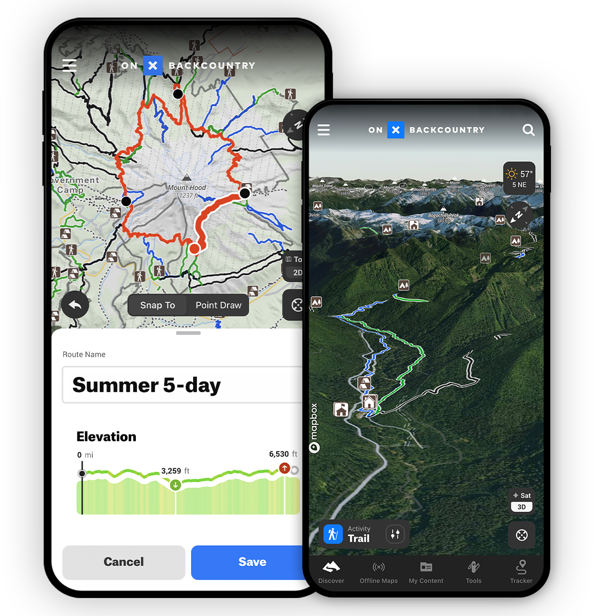
Route Builder
Build custom routes seamlessly on your desktop or phone with Route Builder’s snap-to-trail functionality. Drop a point to start, then another in whatever direction you want to go, and a route will automatically connect via the closest trail or road.
Air Quality
The Air Quality Index layer displays areas where particulates in the air are at unhealthy levels. Wildfire smoke and pollution are the two main causes of poor air quality. Use this layer to determine if it is safe to recreate outside during peak wildfire season.
Smoke Forecast
The Wildfire Smoke Layer visualizes smoke density in the atmosphere from wildfires. Use this layer to see where smoke from nearby wildfires is drifting, and use in conjunction with the Air Quality Index layer to determine if it is safe to be outdoors. The layer is updated hourly, and the data is sourced directly from AirNow.gov.

Offline Access
Use Offline Maps to download maps to your phone that include all of the markups you’ve made for any selected area. When you’ve turned your Offline Map on, the GPS in your phone will connect to satellites to give your real-time location—even when cell signal is long behind you.
How to use onX Backcountry for Skiing and Splitboarding
Learn how to use onX Backcountry on your next skiing or splitboarding adventure. This in depth video will showcase how to use every feature of the app to its fullest.

Snow Mode
Snow Mode allows you to view ski touring, cross-country skiing, and snowshoe trails, along with slope angles, and avalanche forecasts. The goal of this mode is to put the tools you need at your fingertips to navigate through avalanche terrain and stay safe in the backcountry.
Digital Guidebooks
This is your new go-to resource when backcountry skiing in Colorado or Washington. onX Backcountry has partnered with Beacon Guidebooks, leaders in backcountry ski guidebooks, to create a first of its kind digital experience which pairs their highly vetted ski lines with our set of critical avalanche safety and navigation information. Learn More

Winter Satellite Imagery
Winter aerial satellite imagery provides an in-depth look at what a mountain looks like with snowpack. Use this to evaluate safe zones, turnaround spots, and avalanche prone areas. Use satellite imagery in conjunction with our snow layers to help plan your route.

Avalanche Forecasts
In partnership with every U.S. based avalanche forecast center, daily forecasts are pulled into the App making it easy to read, drink your coffee, and plan your day’s tour.

Slope Aspect
Absolutely integral to avalanche safety—slope aspect is the cardinal direction the slope of a mountain faces. Understanding this allows you to gauge how much sun exposure that slope experiences, how much snow it could hold, and how prone it is to slide. Learn More.

Slope Angle
This map Layer color-codes the angle of the slope on a given terrain feature with green representing lower angles and purple representing steeper. Mainly applied in a backcountry ski and splitboard setting, Slope Angle is the most vital measure of avalanche risk. Learn More.

SNOTEL Station Data
The best data source for current snow accumulation data in the mountains is SNOTEL (Snow Telemetry) which uses remote stations to measure snow depth, snow/water equivalent, and temperature. Learn More.
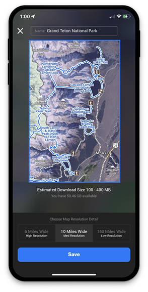

Offline Maps
No Cell Service Required
When to Use Offline Maps
Save an Offline Map before any trip into the field—even areas with widespread cell coverage may have small pockets in which service may drop off. In the event that you find yourself in an area with spotty or nonexistent cell service, you’ll still have access to your map.
Offline Maps 101
Quickly and easily download maps to your phone before heading into the field. Offline Maps are easy to update and sync to your account as soon as you return to service. Your live location information is based on your phone’s built-in GPS, so you’ll see a blue dot on the screen telling you exactly where you are at all times.

Basemaps for Adventurers: Topographic, 3D, and Beyond
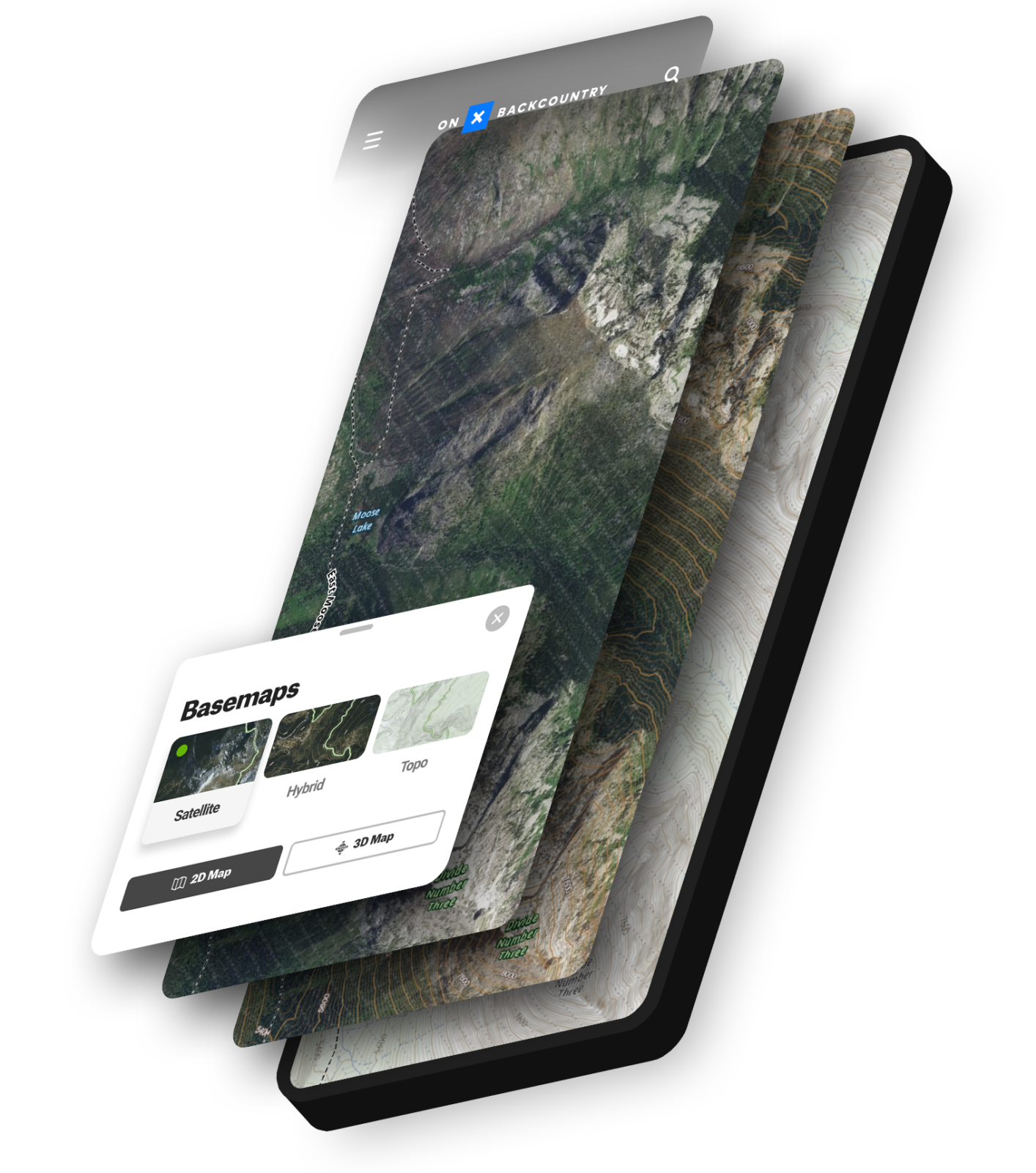
Satellite, Hybrid, and Topo Basemaps
onX Backcountry offers a range of Basemaps, each serving a distinct purpose in enhancing your understanding of the terrain and facilitating navigation. The Satellite Basemap presents aerial imagery, providing a visual depiction of the landscape from above. The Topographic Basemap offers a two-dimensional representation of the Earth’s intricate three-dimensional topography, aiding in comprehending elevation and contour lines. The Hybrid Basemap seamlessly combines the advantages of both Satellite and Topographic maps, delivering a comprehensive and detailed view of the land. Whether you’re a hiker or a backcountry skier, onX Backcountry ensures you have the most accurate and comprehensive map options at your disposal for a successful outdoor adventure.
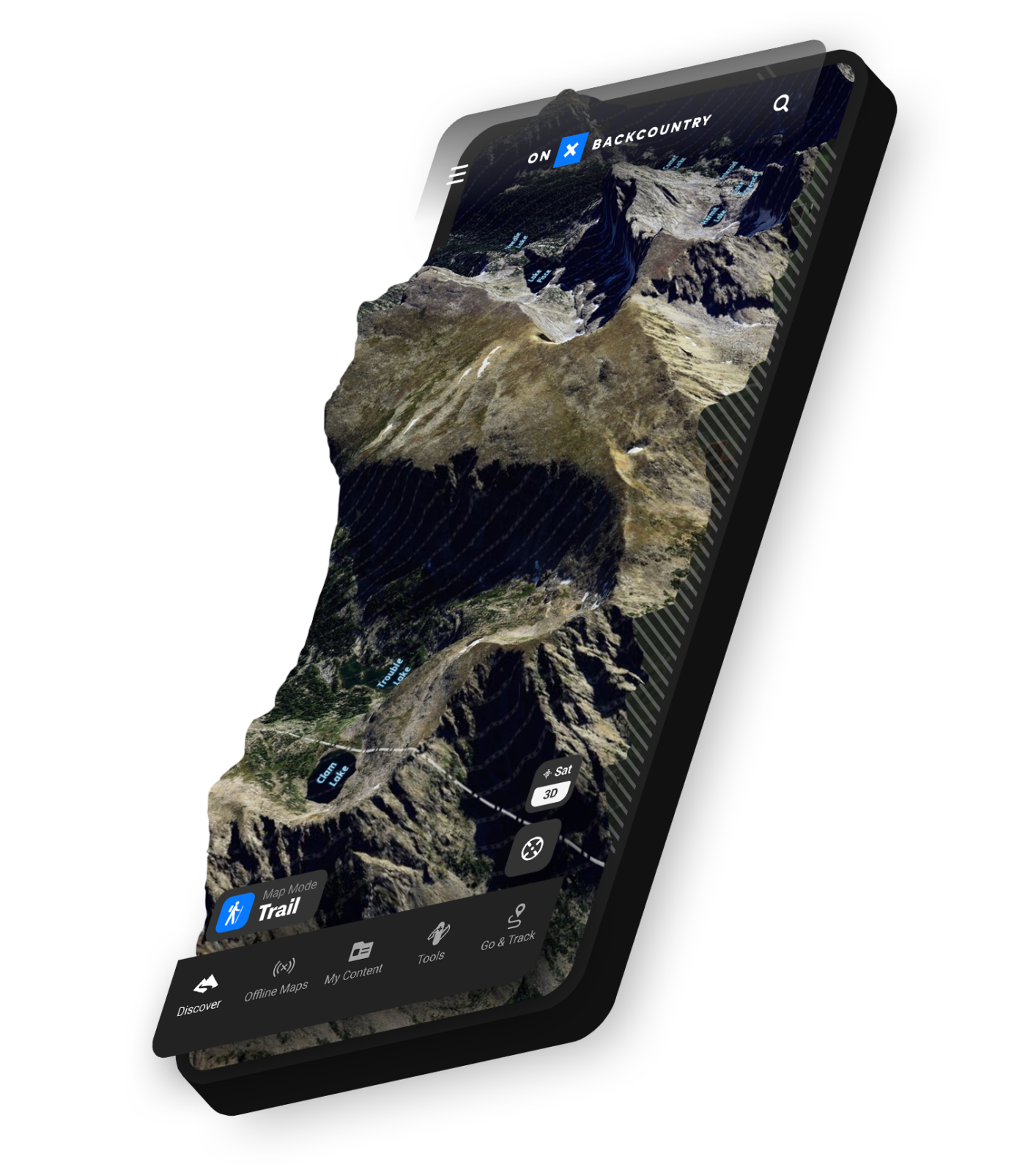
Visualize Your Adventure in 3D
Planning a backcountry ski tour, hike, or adventure is more fun and helpful in three dimensions. Use onX Backcountry’s 3D Maps to explore these areas virtually to visualize your journey all before hitting the road.
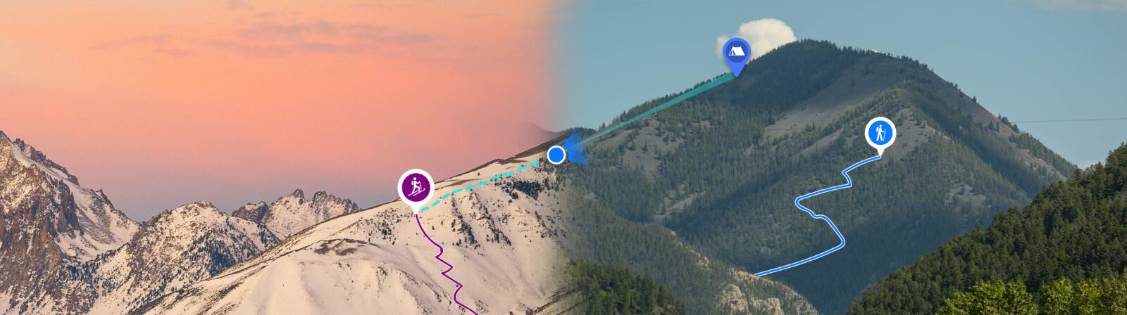
Map Tools: Customize and Share Waypoints, Tracks, and Areas
![]()
Build Your Map
Mark and customize waypoints to highlight points of interest, decision points, or potential campsites. Use the Line Distance Tool or Route Builder to plan your route along your skintrack or hike and see milage and elevation gain and loss. While in the field, use the Tracker to follow your route to keep on track and ensure you find your way back.

Share Your Beta
Share your custom maps with friends who will accompany you on your trip, or who want to follow in your footsteps. With onX Backcountry, you can share your waypoints, tracks, lines, and area shapes via a share link or by exporting GPX files.
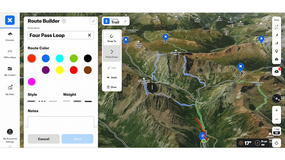
Route Builder
Plan your route faster than ever
Plan your route with onX Backcountry’s Route Builder. Easily and quickly create routes that snap-to trails on your map so you can plan your adventure, see the distance, as well as elevation gain and loss. Once you’ve built your route you can save and share them with your family and friends.
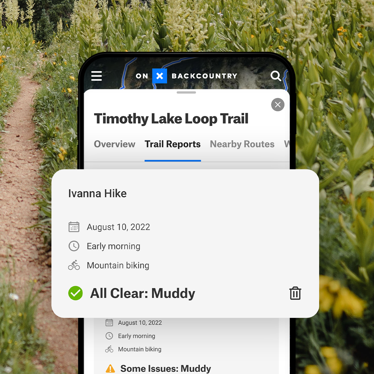
Trip Report
View Current Trail Conditions
Stay in the know and hike with confidence with Trail Reports. Now you can view and submit current conditions and trail closures right in the App. Know where you can go and what conditions are with our Trail Report feature.
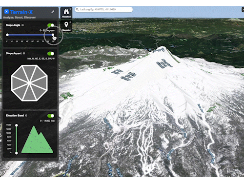

Terrain X [Beta] – Elite Exclusive Feature
Analyze, Scout, and Discover with Terrain X on your desktop computer. This elite only feature allows you to choose which slope angle, slope aspect, and elevation band you’d like to explore and shows you which terrain meets this criteria by color coding them on the map.
You can also use the “Viewshed” feature to see where your line of sight will be from any given location on the map.
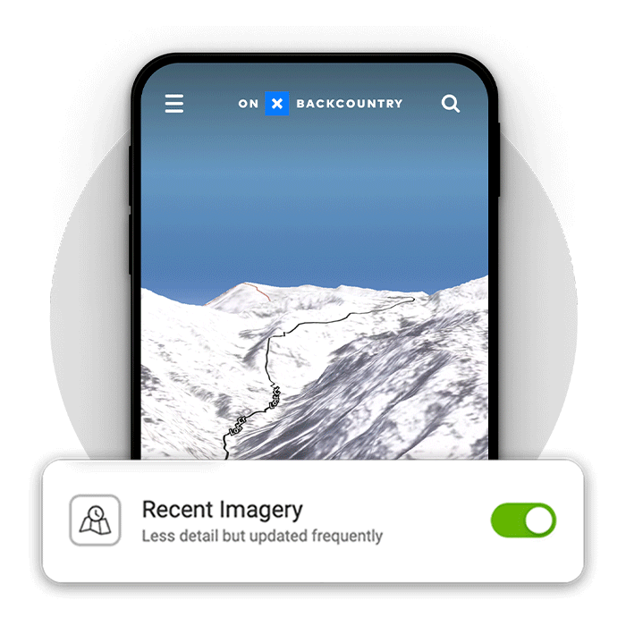
Recent Imagery – Elite Exclusive Feature
Updated every 1 to 2 weeks, recent imagery allows Elite subscribers to see current conditions anywhere in the United States with unparalleled detail. Our recent aerial imagery is twice as detailed as free sources (5 meters/pixel vs. 10 meters/pixel). Customers can use aerial imagery to determine whether a route is safe to hike or has enough snow to ski.
Wind & Weather in the onX Backcountry App
Weather Updates From 100,000 Weather Stations, Updated Every 15 Minutes
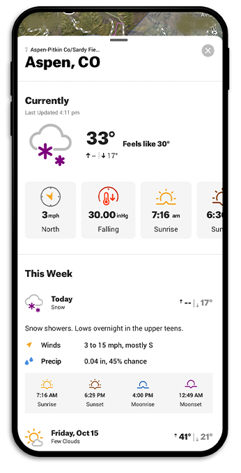

Current and Forecasted Weather
With thousands of weather stations displaying temperature, sunrise / sunset times, 7-day forecasts, and more, all the weather information you need is in the Backcountry App.
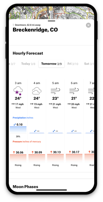
Wind Data, Right in the App
View a detailed hour-by-hour forecast of wind speed and direction for the upcoming eight days at any specific location on your map. Stay informed about the potential fluctuations in wind direction throughout the day, as well as changes in barometric pressure and precipitation patterns. Whether it’s adjusting your tactics or modifying your approach, onX equips you with the knowledge you need to make informed decisions based on the ever-changing weather dynamics.
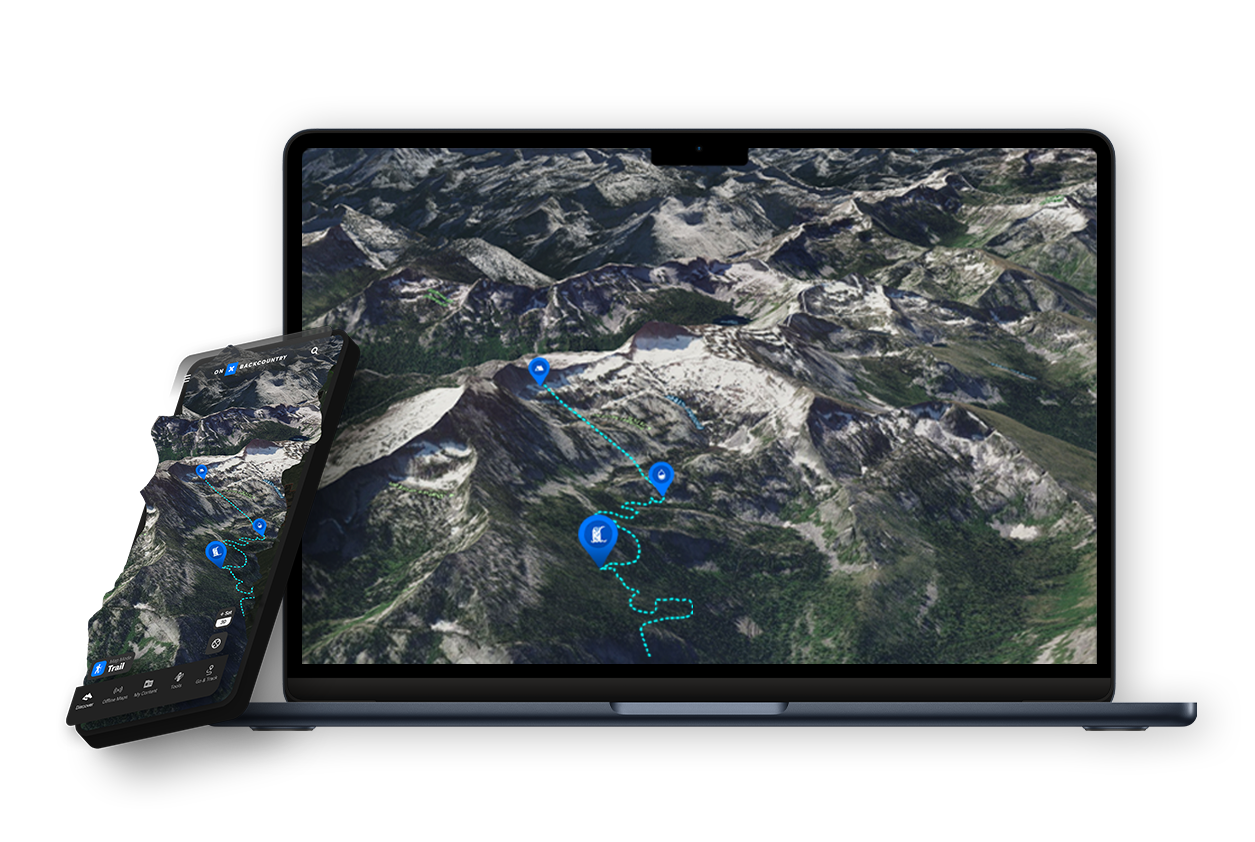
Desktop Maps for Better Planning
Sync Your Maps Across All Devices
onX Backcountry members get complete access to onX Backcountry on their desktop computers—perfect for serious planning on a bigger screen. Using desktop maps with 3D Mode allows you to research, evaluate, and plan for a hunting area before you get out in the field. Your Map Markups (Waypoints, Lines, Shapes, and Tracks) and all the data you save on your desktop syncs across all of your devices so you can take advantage of scouting time to be more efficient, knowledgeable, and successful when you hit the trail.
Navigation Tools: Tracker and Compass
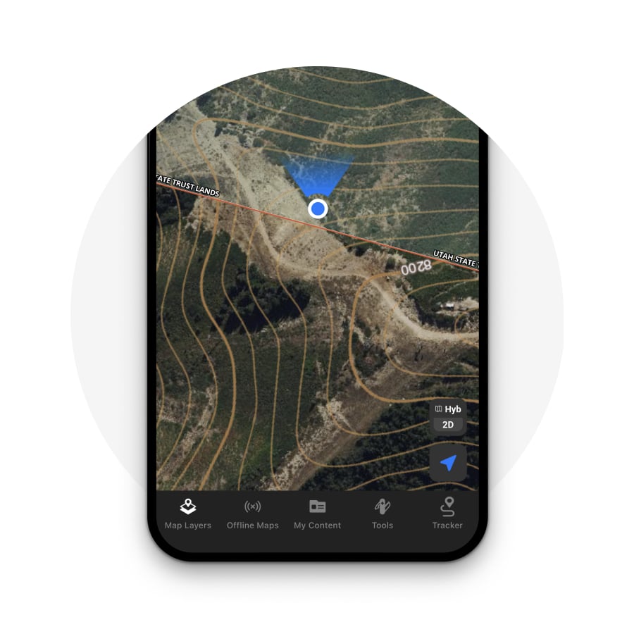

Compass in the Backcountry App
Use the compass right in the onX Backcountry App to find your location and orient yourself. Give the Location Button on the bottom right corner of the App one tap to center the map on your current physical location, tap twice to rotate the map in the direction you’re facing, and tap three times to rotate the map back to a north-up orientation.
![]()
Use Tracker to Mark Your Trail
The Tracker feature allows you to record your path as you travel and saves it on your map, taking the guesswork out of backtracking so you can have the confidence to explore the unknown. You’ll also see the time the trip took, as well as distance and average speed. This data is saved along with the Track and can be viewed in the My Content menu.
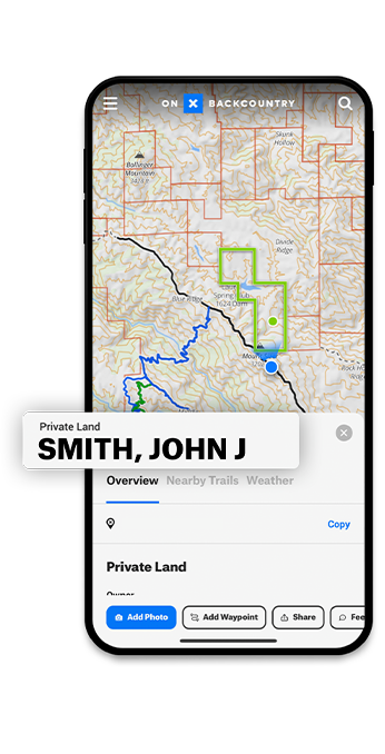
Land Ownership Data with onX Backcountry Elite
The Most Accurate Land Ownership Data
Explore property boundaries confidently using advanced GPS tracking and regularly updated, clearly defined boundaries. Our dedicated Geographic Information System (GIS) team employs exclusive techniques for data collection, analysis, and layering, ensuring that you have access to the most accurate and up-to-date maps across all your devices, conveniently consolidated in one place.
Dive Into Detailed Land Information
Discover an expansive wealth of information on over 121 million properties nationwide through onX. Effortlessly visualize property lines and names directly on the map, and with a simple tap, access details such as landowner names, tax addresses, and acreage. Prepare for your next adventure with maps encompassing an astounding 852 million acres of public land, over 400,000 miles of trails, and a vast array of 50,000+ campgrounds and cabins.

Try onX Backcountry Today
Take your outdoor adventures to the next level with a free onX Backcountry trial. Explore uncharted territories, discover hidden trails, and navigate with confidence using the powerful GPS mapping features of onX. Don’t miss this opportunity to unlock a world of outdoor possibilities—sign up for your free trial now and let the exploration begin!