onX Backcountry Elite
Take your adventure planning to the next level with onX Backcountry Elite. onX Backcountry Elite shows you private land boundaries and ownership information for the entire country. Discover more access when you know where you can legally hike, backcountry ski, or camp.
Take your adventure planning to the next level with onX Backcountry Elite. onX Backcountry Elite shows you private land boundaries and ownership information for the entire country. Discover more access when you know where you can legally hike, backcountry ski, or camp.
Nationwide Private Land Boundaries + Ownership Info
onX Backcountry provides outdoor enthusiasts with essential information about the terrain they are exploring. With the Private Land Layer, you can see the boundaries of privately owned land as well as landowner information. This is particularly important for hikers, backcountry skiers, and other outdoor enthusiasts who want to ensure they are not trespassing on private property. This is a valuable tool for anyone who wants to explore the backcountry responsibly and respectfully. With the Private Land Layer, onX Backcountry has made it easier for outdoor enthusiasts to navigate their surroundings and enjoy their favorite activities without infringing on others’ property rights.
Elite vs Premium Memberships
In addition to nationwide private land boundaries and ownership information, the onX Backcountry Elite membership includes all the paid features of Premium, including access to 650k miles of color-coded trails for hiking, backcountry skiing, cross country skiing, and snowshoeing. Elite lets you discover more access because you’ll always know where you can legally hike and camp.
Already an onX Backcountry Premium subscriber? Upgrade to onX Backcountry Elite today to unlock the private lands layer. Click the link below to upgrade your subscription.

Recent Imagery
Updated every 1 to 2 weeks, recent imagery allows Elite subscribers to see current conditions anywhere in the United States. Our recent aerial imagery is twice as detailed as free sources (5 meters/pixel vs. 10 meters/pixel). Customers can use aerial imagery to determine whether a route is safe to hike or has enough snow to ski.
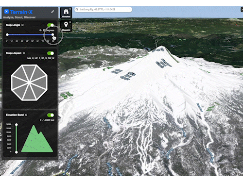
Terrain X [Beta] – Elite Exclusive Feature
Analyze, Scout, and Discover with Terrain X on your desktop computer. This elite only feature allows you to choose which slope angle, slope aspect, and elevation band you’d like to explore and shows you which terrain meets this criteria by color coding them on the map.
FAQs
Depending on whether you purchased onX Backcountry on our website, on the Apple App Store, or on The Google Play Store there are different steps required to upgrade your account to Elite. Visit our Upgrade tool and log into your account for more information on how to upgrade your account. https://www.onxmaps.com/backcountry/upgrade
Yes: The free version of the App includes satellite, topo, and hybrid maps, as well as the ability to Track your trips and add markups.
Free does not include trail information, public land boundaries, recreation points, slope angle and slope aspect layers, and the ability to download unlimited offline maps. Upgrade to Premium or elite to access all of the App’s adventure potential.
The onX Backcountry free trial includes full access to Elite for seven days. During the free trial, users will be able to access satellite, topo, and hybrid maps, see open and closed off-road trails, discover Featured Trails with trail descriptions and photos, save unlimited offline maps, Track trips, add Waypoints, and share trails and markups with other Backcountry users.