The onX Offroad Elite App Now Available in Canada
We’re stoked to announce that the #1 off-road GPS mapping App is now available in Canada and includes access to motorized trail maps for Canada, the US, and Baja.
All core onX Offroad App tools have now been combined with mapping layers specifically for Canada. Available maps include Aerial, Hybrid, and land data showing lands held by government, tribal, province, and other government agencies. Key features such as Tracker, Waypoints, and Offline Maps turn your phone into a GPS for use off the grid, and our Route Builder lets you plan epic custom adventures.
Canada layers are available as part of the onX Offroad Elite membership, including maps for the U.S., Canada, and Baja. Elite members also get access to exclusive discounts with our industry-leading brand partners.
Use the onX Offroad App in Canada
Turn your phone into a handheld off-road GPS + trip planner
Off-Road Maps for Canada
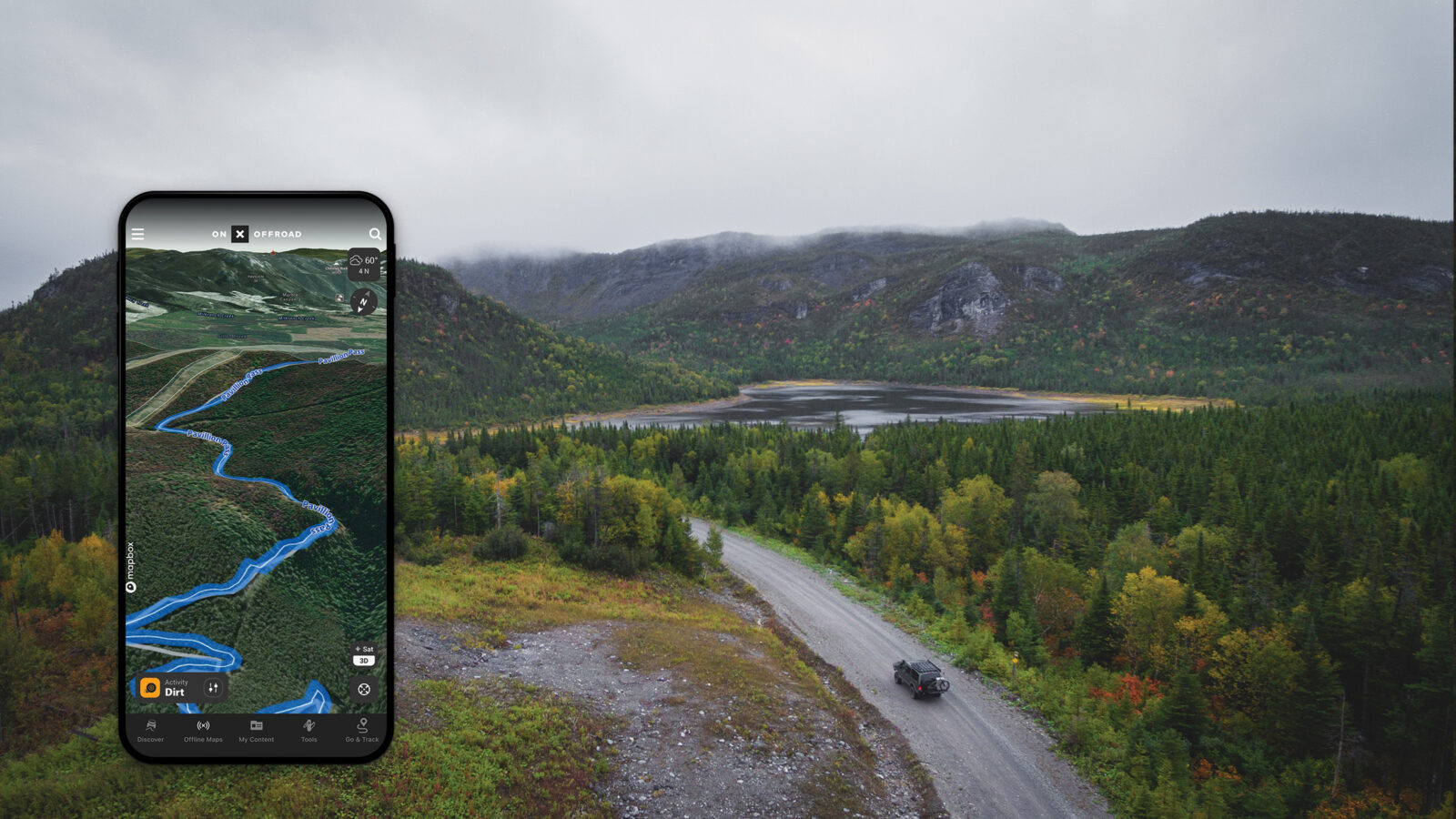
Current maps and features available for Canada in the onX Offroad App:
- Basemaps
- Satellite, Hybrid, and Topo Basemaps for motorized trails to help off-roaders understand the landscape and courses, locate open-use areas, and find dispersed camping.
- 3D Maps
- Industry-leading 3D maps bring the terrain to life so you can dive into a canyon and check rock crawl areas, climb along a mountain trail to understand the elevation gain, and drop Waypoints along your route to mark junctions, obstacles, or campsites.
- Public + Private Land
- See clearly marked boundaries for lands held by government, tribal, province, parks, etc., and nationwide coverage for parcel lines (where available) without landowner names.
- Route Builder
- Plan endless adventures with Route Builder. Create custom Routes seamlessly on your mobile device with our snap-to-trail functionality. Add Routes to trip folders and share them with your buddies so they can add them to their onX Offroad App.
- Folder Sharing
- Go ahead and be the trip leader because Folder Sharing lets you add Routes, Waypoints, Tracks, and map markups to your custom Folders to easily coordinate plans, share an adventure post-trip, organize your content, and keep your maps clutter-free.
- Waypoints + Tracks
- Make your maps your own. Save, share, and relive your adventures—mark meet-up locations, trailer parking, dispersed camping, or anywhere else you don’t want to forget with Waypoints. Record where you’ve been to know how to get back and keep a collection of your trips to relive and share with Go & Track.
- Snow Mode
- Discover more snowmobile access when you know where you can ride. Locate trails and open riding areas suited for any experience level with nationwide snowmobile trail maps for Canada and the U.S. and data for Avalanche Forecasts, Slope Angle, and SNOTEL recent snow totals (U.S. only). Color-coded maps mark inaccessible and wilderness-designated areas so it’s easy to find where you can ride.
- Offline Maps
- Get home safely–from anywhere–with Offline Maps. Save custom-sized Offline Maps to always know where you are no matter how far off the grid you go and have access to full location and trail data outside of cell coverage.
Off-Road GPS Tools
- Location – Navigate by following the blue dot from your phone’s internal GPS, even when you’re outside cell coverage on the trail, and always know how to get home–wherever home is that night. Learn more about finding your location.
- Waypoints – Mark any location on the map with a Waypoint, or mark your current location quickly with a few finger taps. Add Waypoints to custom Folders or share directly with your buddies to coordinate your trips. Learn more about Waypoints.
- Go & Track – Go & Track’s GPS capabilities record your trip stats and leave a breadcrumb trail along your route to lead you back safely. Track your speed, direction, and distance to save your route so you can brag to your buddies or retrace your adventure later. Learn how to use Go & Track.
Off-Grid Trail Maps
As we all know, cell coverage can get pretty spotty in the backcountry, so the ability to save maps onto your mobile device for use outside the cell network is crucial. The onX Offroad App comes with a built-in system for saving map and trail data onto your device so you never have to worry whether or not you’ll have coverage in the area you’re exploring. Learn more about using Off-Grid maps.
Try the onX Offroad App in Canada
Handheld Motorized Trail Maps + GPS Navigation for Canada, U.S., and Baja