Off-Road Trails in Arizona
Discover off-road trails in Arizona
Learn more about Exit Off Spruce Mountain Road
Exit Off Spruce Mountain Road
Total Miles
2.5
Tech Rating
Easy
Best Time
Summer, Spring, Fall
Learn more about Experimental and Rocky
Experimental and Rocky
Total Miles
1.6
Tech Rating
Easy
Best Time
Spring, Summer, Fall
Learn more about F-14 Tomcat Crash Site Spur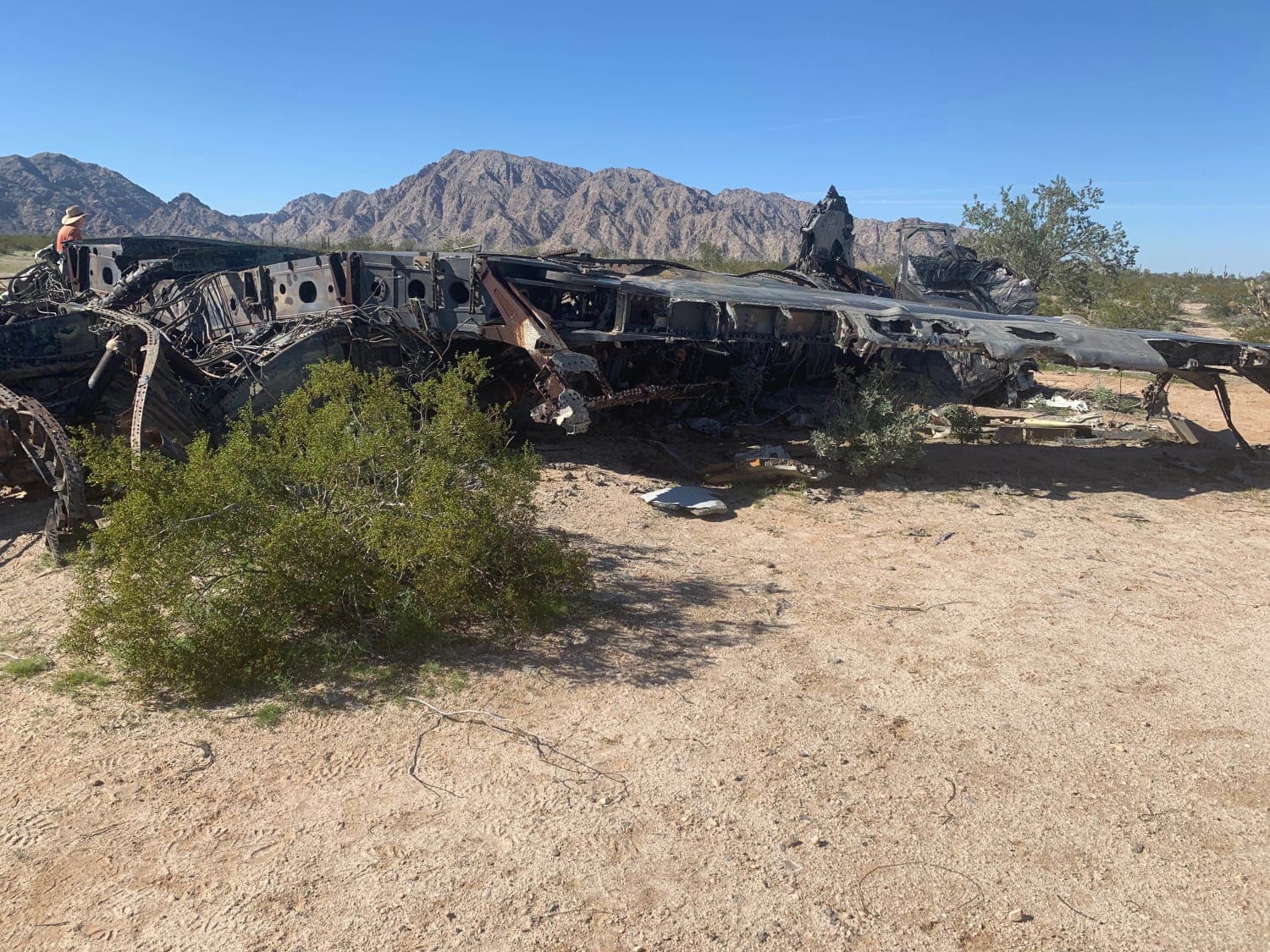
F-14 Tomcat Crash Site Spur
Total Miles
2.5
Tech Rating
Easy
Best Time
Spring, Summer, Fall, Winter
Learn more about F-4 Phantom Crash Site Spur
F-4 Phantom Crash Site Spur
Total Miles
6.6
Tech Rating
Easy
Best Time
Spring, Summer, Fall, Winter
Learn more about Fair Oaks to Spider Ranch
Fair Oaks to Spider Ranch
Total Miles
8.7
Tech Rating
Easy
Best Time
Spring, Summer, Fall
Learn more about FairOaks West
FairOaks West
Total Miles
3.5
Tech Rating
Easy
Best Time
Spring, Summer, Fall
Learn more about Falcon Valley Ranch Access
Falcon Valley Ranch Access
Total Miles
2.6
Tech Rating
Easy
Best Time
Spring, Summer, Fall, Winter
Learn more about Fancher Mine Loop
Fancher Mine Loop
Total Miles
2.3
Tech Rating
Moderate
Best Time
Winter, Fall, Spring
Learn more about FDR 1863 South Loop
FDR 1863 South Loop
Total Miles
9.2
Tech Rating
Easy
Best Time
Spring, Winter, Fall, Summer

Learn more about FDR 3705
FDR 3705
Total Miles
0.6
Tech Rating
Moderate
Best Time
Spring, Summer, Fall, Winter
Learn more about FDR 64/Marapai Road
FDR 64/Marapai Road
Total Miles
2.3
Tech Rating
Moderate
Best Time
Spring, Summer, Fall
Learn more about Fence Line Connector
Fence Line Connector
Total Miles
1.1
Tech Rating
Easy
Best Time
Summer, Fall, Winter, Spring
Learn more about Fence Line Drop In
Fence Line Drop In
Total Miles
0.2
Tech Rating
Easy
Best Time
Spring, Summer, Fall
Learn more about Fence Line Maintenance
Fence Line Maintenance
Total Miles
1.3
Tech Rating
Easy
Best Time
Spring, Fall, Winter
ATV trails in Arizona
Learn more about Scrub Oak Bypass 
Scrub Oak Bypass
Total Miles
0.5
Tech Rating
Easy
Best Time
Spring, Summer, Fall


UTV/side-by-side trails in Arizona
Learn more about Scrub Oak Bypass
Scrub Oak Bypass
Total Miles
0.5
Tech Rating
Easy
Best Time
Spring, Summer, Fall
The onX Offroad Difference
onX Offroad combines trail photos, descriptions, difficulty ratings, width restrictions, seasonality, and more in a user-friendly interface. Available on all devices, with offline access and full compatibility with CarPlay and Android Auto. Discover what you’re missing today!