Everything was going according to plan. My friend John and I had crawled from our tents in the pre-dawn darkness and by the time the sun was warming the mountainside, we were up the slope’s steep face and navigating the ridgeline in search of Pennsylvania spring turkey.
Stopping at the edge of a bog, we let out a few clucks and a call echoed back from the bright green depths of the state forest—a promising sign that the hunt was on.
As we headed further west, enticed by the prospect of drainages and points, our plan crashed into a wall. My e-scouting of the area had accounted for elevation, topography, food sources, distance from roads, and weather. What my map hadn’t revealed was what lay hidden beneath these tree canopies: a literal wall of mountain laurel.
TL;DR: Mountain laurel is one of the most punishing and disorienting forms of cover Eastern hunters encounter, hiding entire hillsides in dense “laurel hells” that block visibility, slow travel, and derail even well-planned hunts. It also offers security for species like deer, black bear, and turkey. onX Hunt’s Leaf-Off Imagery flips laurel from unseen obstacle to strategic asset by using winter satellite imagery to reveal understory and the true size and shape of laurel thickets. With this visibility, hunters can plan efficient routes in and out, target edges and funnels instead of blindly pushing through, coordinate safer and more effective drives, and pair thick cover with nearby food sources, turning some of the East’s hardest terrain into a high-odds hunting opportunity.
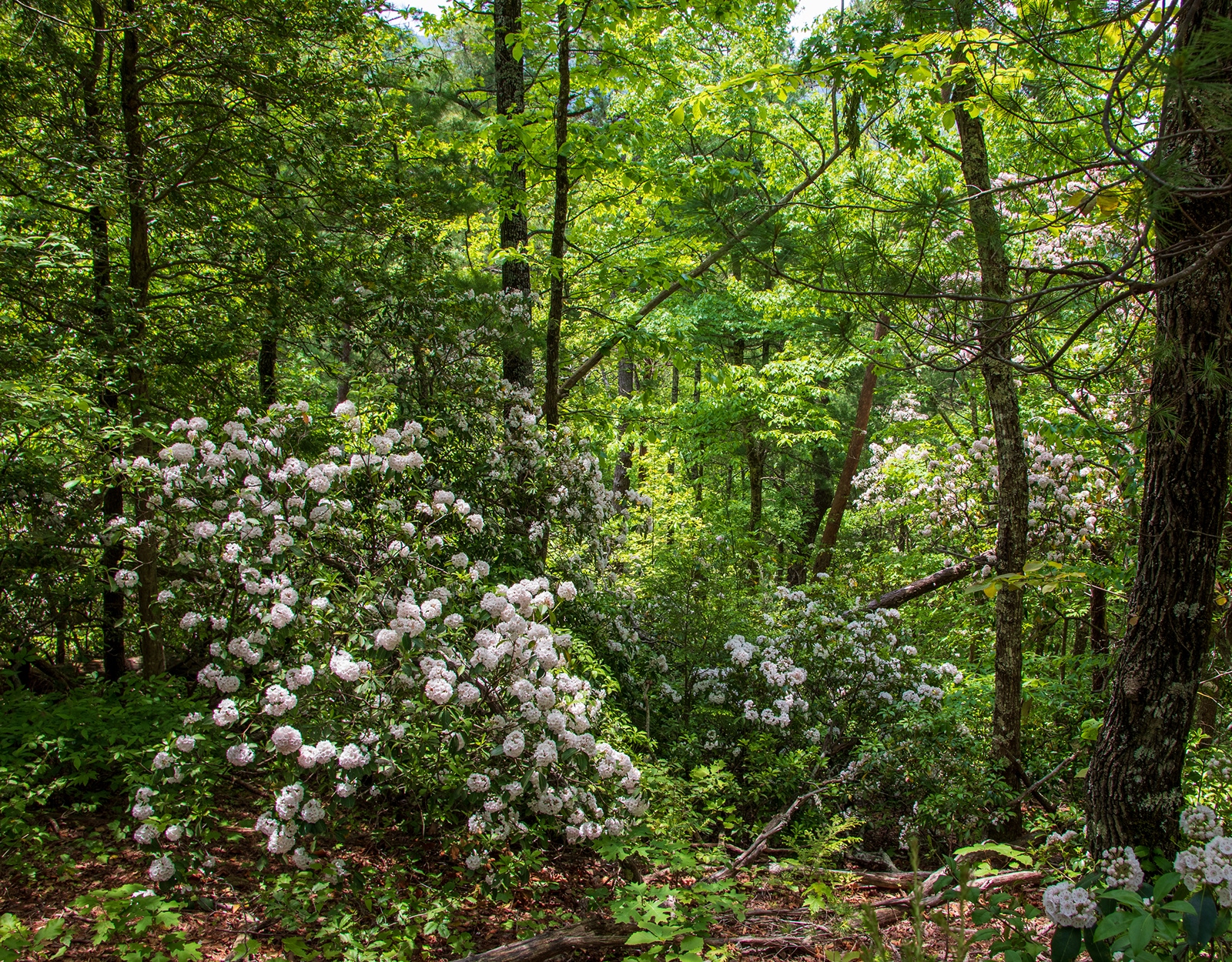
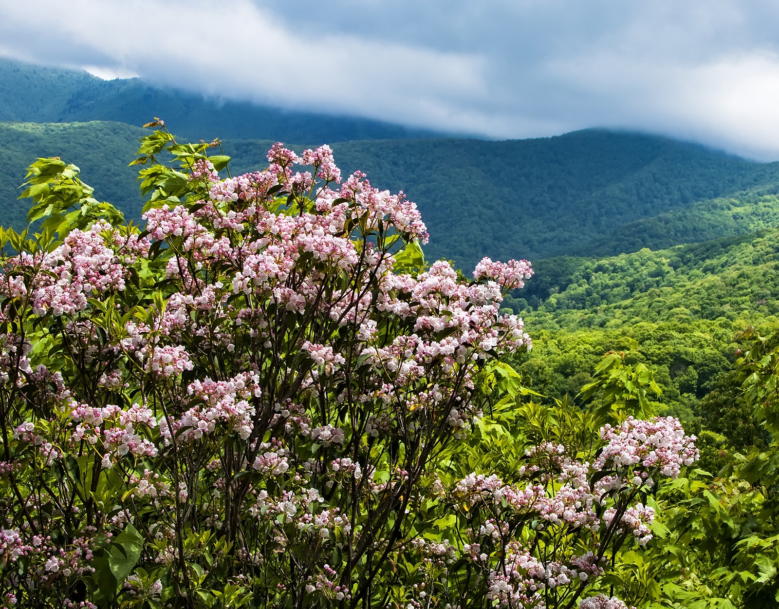
An evergreen shrub, mountain laurel is Pennsylvania’s state flower, though its range sprawls from southern Maine to northern Florida. When it blooms in early May, the spectacular profusion of delicate white and pink blooms draws tourist crowds. “All down the rocky slope is spread thy veil of rosy snow,” penned author Louisa May Alcott in a love poem to the plant.
Eastern hunters are likelier to describe it using four-letter words.
On mountain balds and high-elevation rocky ridges, mountain laurel grows into dense thickets that can extend for acres. Early settlers in the U.S. called these expanses “laurel hells” and in the Smoky Mountains, place names like Huggins Hell and Jeffrey’s Hell recall lore of men and dogs who became hopelessly lost in this witchy greenery.
In the 1906 book Camping and Woodcraft, Horace Kephart recounts how a pair of Tennessee mountain men spent two days in laurel while traversing just three or four miles. When Kephart asked how they managed to get out, they replied: “We couldn’t crawl—we swum.”
At the outset, there is something deceptively harmless about laurel, at least to a hunter accustomed to rough briars. There are no thorns to get snagged on and the ropy, flaky branches are flexible enough that you can push them aside.
Still full of morning gumption, John and I began shouldering in—placing a foot here, pushing that branch aside, swinging a gun through, ducking down. Each step forward yielded the same result: more mountain laurel. Laurel typically grows up to six to ten feet but can reach heights of 30 feet. We could not see above it. We could not see to the left or right of it.
We blundered on, at times pushing through stuff so thick it obscured the sight of our own feet—perhaps why loggers call these laurel growths “ankle-breakers.” Trying to navigate through a big laurel stand summons a feeling of paddling into the deep: where you set out from begins to feel as perilously distant as the point you are trying to reach.
When we came within a few feet of stepping on a furious timber rattlesnake, it seemed as good a time as any to admit that we were beat, with retreat the only option.
Names like Huggins Hell and Jeffrey’s Hell recall lore of men and dogs who became hopelessly lost in this witchy greenery.
Leaf-Off Imagery: Turning Mountain Laurel from Foe to Friend
Mountain laurel robs a hunter of sight and silence, which is precisely why it makes ideal cover for big game animals like deer and bear.
“It’s awesome security, especially when the guns start cracking,” says Mitchell Shirk, host of the Pennsylvania Woodsman podcast. “I don’t know that I’ve ever gutted a doe that, when I checked the stomach, it didn’t have mountain laurel in it.”
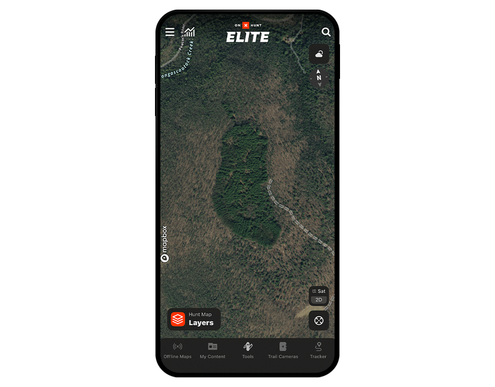
An underexplored tool of onX Hunt’s Elite Membership—the Leaf-Off Imagery Basemap—transformed my bitter feelings about laurel, helping me to see it as an asset rather than an obstacle.
How Leaf-Off Imagery Works
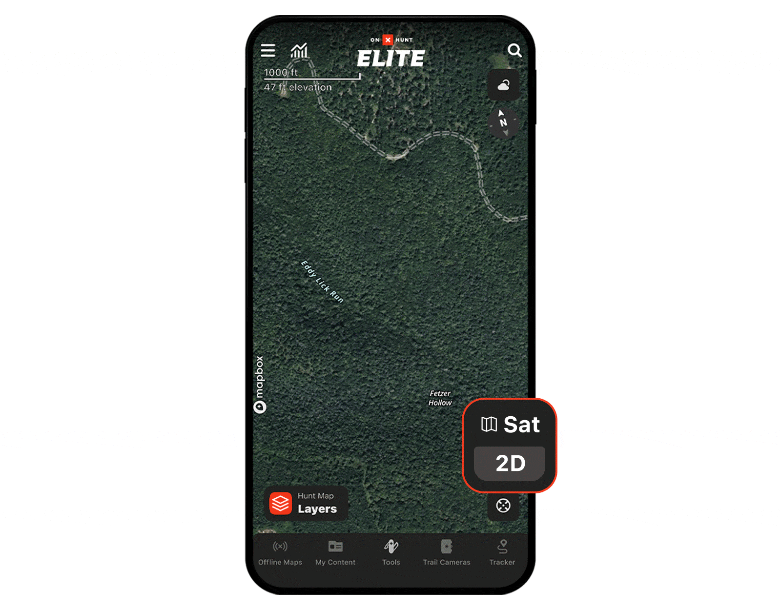
Leaf-Off Imagery, available in select states, uses satellite imagery taken during winter seasons to peek beneath overstory, making forest floors visible to hunters. It can help identify deer trails, creek beds, cedar thickets, and other nuances of terrain, as well as understory that remains illegible in normal digital maps.
It’s also a breakthrough application for cracking the code of mountain laurel, whether you’re trying to navigate topography efficiently or searching for mature bruins and bucks in remote places out East.
When I revisited the state forest where we hunted turkey on the onX App and switched on Leaf-Off Imagery, I was astonished. Depicted there was the entirety of the laurel that had tortured us, now clear as day, like a shore of light green against the bare brown expanse of empty winter woodlands. Rattlesnakes aside, my visibility was restored.

Depicted there was the entirety of the laurel that had tortured us, now clear as day.
Leaf-Off Imagery for Navigation
The only thing worse than pushing through mountain laurel is doing so without any clue where you are going. Using Leaf-Off Imagery, you can plan how best to orient around or through laurel thickets. You might avoid an impassable area entirely, find the patchiest or shortest distance to cross it, or identify open corridors or breaks in laurel that might save you hours of time in the field.
This feature can prove as important to planning your exit as your way in. If you harvest a big bear in a remote or mountainous area, you’re usually better off packing that animal out—a Western technique that’s catching on among backcountry hunters in Eastern states like Pennsylvania. With Leaf-Off Imagery, you can find the quickest routes out of or through laurel and back to the truck.

With Leaf-Off Imagery, you can find the quickest routes out of or through laurel and back to the truck.
Leaf-Off Imagery for Solo Hunting
When hunting pressure kicks in, deer and bear head for mountain laurel. In radio-collared studies of bear movement in northcentral Pennsylvania, Game Commission black bear biologist Brandon Snavely found that over 50% of bears den in laurel. These dens often take the form of ground nests: Bears bite the new growth off the laurel and lay the pieces down in formations resembling big bird nests.
If you’re hunting by yourself or with a partner, blindly exploring laurel is a low-odds, noisy tactic. Instead, Snavely suggests working the edges of laurel and focusing on travel corridors, which you can identify in advance with Leaf-Off Imagery.
By toggling to this Basemap, you can cross-reference with other layers like Acorn Producing Oaks to find where laurel coincides with hard mast hotspots. Snavely also suggests looking for sassafras, dogwoods, and black gum located near laurel—species that bears often build tree nests in.
“If you’re going to be hunting in laurel, you want to be in that spot with the cover and the food overhead dropping down in that area,” says Snavely. If you’re only looking at food, without seeing the cover, you’re missing half the picture.
This past fall, hunting thick laurel was how Shirk landed a buck on the last day of the season. Posting up at the edge of a dense laurel patch near a transition area, his visibility was poor, no more than 30 yards in places—but it proved to be a smart location. When a deer came through, “I literally had the size of a softball that I could see its neck,” says Shirk. But it was enough.
Leaf-Off Imagery for Bear and Deer Drives
Bear and deer drives are time-honored traditions in Pennsylvania. Trying to organize how 15+ hunters are going to push through some of the state’s thickest vegetation and gnarliest terrain in a coordinated fashion can quickly become a complicated operation.
Walking through laurel will always be hard—no app layer is going to change that. But with Leaf-Off Imagery, hunters can make sure they’re doing it strategically. With visibility gained on laurel, a drive leader can measure the dimensions of a laurel stand with the Line Distance tool and determine how many drivers will be needed and how far to space them apart.
“Especially for bear, when you get into an area that’s thick, if you’re stretched thin, you won’t get a bear out,” says Shirk. “A mature bear will slip back between drivers. They’ll circle around.”
Meanwhile, standers can use Leaf-Off Imagery to look for escape routes out of laurel, like creek bottoms or natural funnels, or choose spots to place stands for a view above the laurel.
Leaf Off, Hunt On
While planning my first bear hunt on public land this past fall, the Leaf-Off Imagery tool transformed my approach to an intimidating stretch of mountain laurel embedded across seven miles of ridges. This area also held the densest concentration of red oaks anywhere in the vicinity.
Following the onX Tracker trail I’d recorded during on-the-ground scouting, I could see exactly where I’d run into the laurel and how I’d followed its edge, looking for a way in.
For the hunt, I chose a new point of entry based on the Leaf-Off Imagery view. I used the Line Distance tool to find the shortest depth of laurel: 259 yards. Two football fields of non-stop mountain laurel is no one’s idea of a fun time—but we would break through a layer of vegetation I imagined would dissuade most other hunters.
This gave me access to a long slope on the other side bracketed at the bottom by private land—the kind of hidden access a public land hunter dreams of.
On the opening day of Pennsylvania’s bear rifle season, in pre-dawn darkness, 30-degree weather, and driving rain, John and I were at it again. Lighting our way with headlamps, we descended a valley to a swollen, fast-running creek, crossed over fallen logs, then walked up 900 feet of elevation through thick mists and past mossy boulders.
We had seen trucks on the gravel game land roads, but up here, there was no one and no sound other than rain on wet leaves. After breaking through the laurel, the slope on the other side flattened into a bench—and there I discovered a bear trail showing recent signs of activity, chewed-off branches, and fresh scat around every bend. Following it had my heart beating—right up until it crossed onto private land.
By then, I was a good two miles away from our route in. To get back to the other side, we had to cross 800 yards of mountain laurel. The physical toll of this was something like being hit on the shins with a wiffle bat 150 times. I still had bruises weeks later.
I had stumbled into laurel hell all over again—but at least this time, thanks to Leaf-Off Imagery, I knew how to show myself out.
Check the Regs
In Pennsylvania, New York, New Jersey, and other states, it is illegal to shoot or take a bear directly from its den. Hunters focusing on laurel should be aware of the regulations in their state. Pennsylvania Game Commission black bear biologist Brandon Snavely notes that if you sneak up on a bear in laurel that appears to be asleep or hibernating, that would be an instance where you should not take the shot.
FAQs
Hunting mountain laurel presents hunters with visibility and navigation challenges. At the same time, once hunters understand how animals like turkey, deer, and black bear use laurel thickets for cover, they can use mountain laurel patches to their advantage by hunting the edges. Additionally, onX Hunt’s Leaf-Off Imagery, available to Elite Members, allows hunters to see through the tree canopy to uncover laurel thickets and plan around them, through them, or with them.
Per the United States Forest Service, whitetail deer do not prefer to eat mountain laurel but will do so under extreme conditions where other food is not available.
Mountain laurel blooms from April to June. It’s an evergreen plant, so even after the bloom is over, the shrubbery remains.
Mountain laurel’s leaves are thick, glossy dark green, oval, and evergreen. Mountain laurel’s flowers grow in clusters, with colors ranging from white to light pink, often with darker pink speckles.
onX Hunt Leaf-Off Imagery is available in AR, CT, IA, IN, KS, KY, MA, MI, MO, MS, NC, NH, NJ, NY, OH, PA, TN, VA, VT, WI, and WV.