Mount Buldoc Memorial Plane Crash Site
Total Kilometers
9.7
Technical Rating
Best Time
Summer, Fall
Trail Type
Full-Width Road
Accessible By
Trail Overview
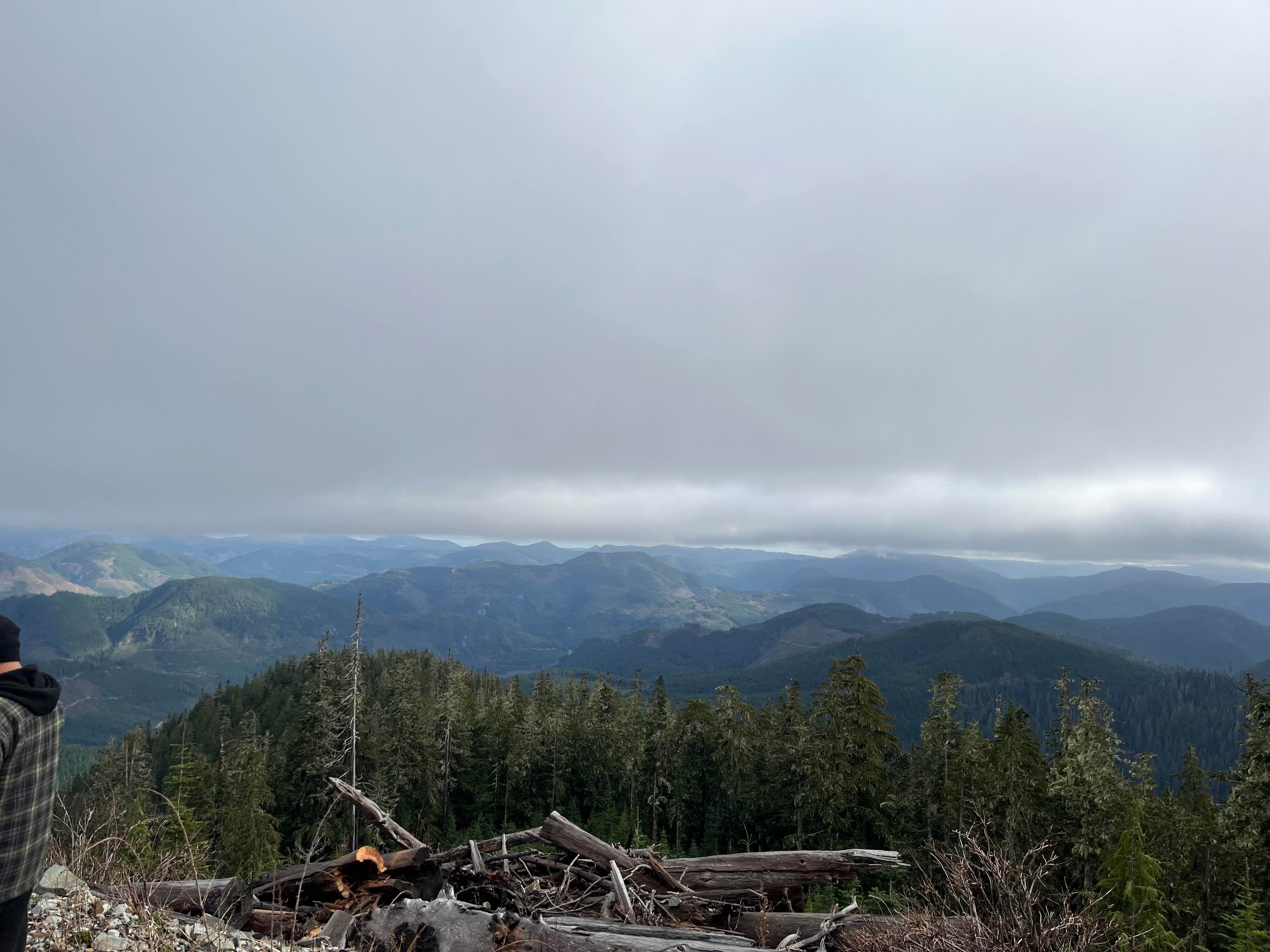
This route ascends to Mount Bolduc via narrow old logging roads, ending at a summit viewpoint and the memorial for the 1944 plane crash. Suitable for drivers comfortable with sustained grades of around 14% and exposed conditions. The peak is around 3500 feet. Expect snowy, slippery conditions during winter. The trail visits a solemn site of historical significance and rewards with broad views over the forests of Vancouver Island's interior.
Photos of Mount Buldoc Memorial Plane Crash Site
Difficulty
The roads are typically one vehicle wide along a steep shelf road. Conditions can become slippery during snowy periods, requiring extra caution.
History
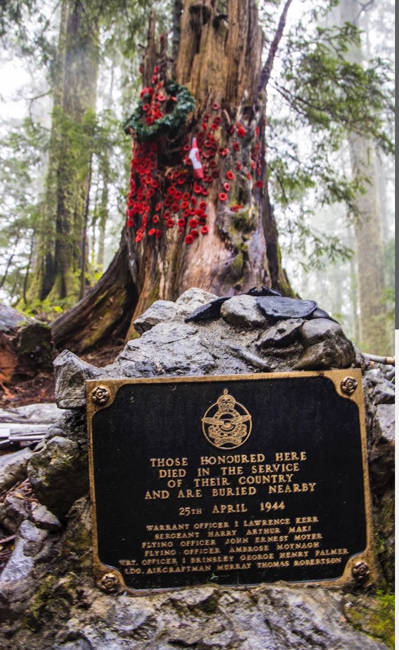
On 25 April 1944, a Lockheed Ventura (sometimes referred to as a Ventura-type bomber) of the Royal Canadian Air Force (RCAF) crashed into Mount Bolduc during a navigational flight. The aircraft was on a routine patrol/navigation flight from Patricia Bay (on Vancouver Island) toward the west coast region. All six crew members on board were killed. The crash occurred on the summit or near the summit of Mount Bolduc (approx. 3,500 feet elevation) -- terrain was steep, forested, and remote. The wreckage was first spotted from the air; ground parties, including loggers from the Lake Logging Company (Rounds) and RCAF personnel, had to scale steep slopes to reach the site. Because removal of the bodies was judged "practically impossible" due to the terrain, the six airmen were buried on-site beneath a cairn, with a combined grave at the summit. Crew names include: FO Ambrose Moynagh (Souris, PEI), PO John E. Moyer (St. Catharines, Ont.), Sgt Harry A. Maki (Sudbury, Ont.), WO1 Brinsley Palmer (Saskatoon, Sask.), WO2 Lawrence Kerr (Millet, Alta.), LAC Murray Robertson (Patricia Bay, B.C.). A memorial/cairn now marks the site, and signage was added in 2005 by the Cowichan Lake Community Forest Cooperative and local partners to honour the crew and help trail visitors understand the history. The crash ties the trail to WWII military history on Vancouver Island and the efforts of RCAF coastal patrol and navigation training during that era. The decision to bury the crew locally rather than recover them reflects the remote and rugged nature of the terrain. The preserved wreckage debris (wing tips, fuselage remnants) and the summit cairn add cultural/historical depth beyond natural scenery.
Status Reports
Mount Buldoc Memorial Plane Crash Site can be accessed by the following ride types:
- High-Clearance 4x4
- SUV
- SxS (60")
- ATV (50")
- Dirt Bike
Mount Buldoc Memorial Plane Crash Site Map
Popular Trails
Pole Cutter FSR
McDonald Creek
The onX Offroad Difference
onX Offroad combines trail photos, descriptions, difficulty ratings, width restrictions, seasonality, and more in a user-friendly interface. Available on all devices, with offline access and full compatibility with CarPlay and Android Auto. Discover what you’re missing today!