How to Scout Ice Fishing Lakes Before You Go
For experienced anglers, success on the ice often starts long before the auger hits the surface. Scouting lakes ahead of time is key to identifying productive fishing spots, planning safe access routes, and ultimately making the most of your time outdoors. This article dives into how onX Fish empowers anglers to scout more effectively—helping you discover new lakes, analyze underwater structure, assess ice conditions, and plan with confidence.
Using tools such as Recent Imagery and CarPlay-compatible GPS navigation, onX Fish gives you the edge to safely and efficiently prepare for your next trip. Whether you’re targeting trophy fish or mapping out seasonal strategies, this guide helps anglers with seasonal ice fishing planning, making safe travel plans, and locating high-potential fishing zones—so you can hit the ice ready and informed.
TL;DR: Successful ice fishing starts before you hit the ice. Use onX Fish to scout lakes, analyze structure, and plan safe access points from home. Filter lakes by species, size, and trophy potential, then study contour maps to find drop-offs, humps, and flats where fish hold. Check Recent Imagery for ice coverage, cracks, and shoreline access, and mark Waypoints for safe travel lanes and fishing zones. Sync your data to CarPlay for hands-free navigation and use Tracker to record your path and return safely. With onX Fish, anglers can confidently find new lakes, plan smarter routes, and fish more productively all season.
Why Scouting Matters for Ice Fishing
Ice conditions and lake features can change rapidly throughout the season. What was a safe access point one week could be unsafe the next, and areas that held fish early in the winter might become less productive as conditions shift. That’s why effective scouting is essential for ice anglers who want to fish smarter and safer.
Experienced anglers rely on mapping tools and recent imagery to remove the guesswork. Instead of drilling blindly, they use digital resources to evaluate lake structure, monitor ice conditions, and plan their routes with precision.
Scouting before you go offers several key advantages. It helps you pinpoint productive, fish-holding areas based on underwater contours and structure. It also allows you to identify and choose safe, reliable access points—critical for avoiding thin ice or hazardous terrain. Lastly, scouting helps you steer clear of high-pressure zones, giving you a better shot at undisturbed fish and a more enjoyable day on the ice.
Step-by-Step Guide: How to Scout Ice Fishing Lakes
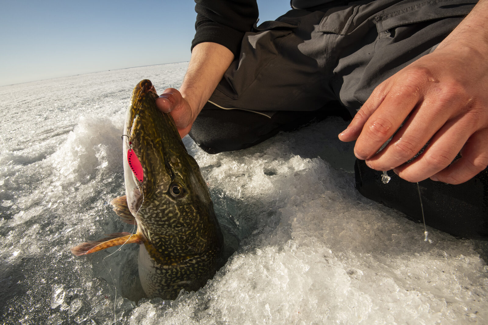
Step 1 – Find New Lakes and the Best Access
onX Fish helps anglers discover new lakes and fishing spots with ease, making it the go-to tool for exploring untapped waters. The main value lies in uncovering new opportunities—whether you’re looking for a quick after-work session or planning a weekend trip to a remote lake. With a paid subscription, users can filter thousands of waterbodies by target species, size structure (from trophy potential to high numbers), waterbody type, and more. Instantly find lakes known for big bass, high-density crappie populations, or under-pressured walleye fisheries, all tailored to your preferences. Once you’ve narrowed it down, onX Fish makes it easy to evaluate public versus private access, boat ramps, and shoreline availability—helping you plan how to get there and fish efficiently. Whether you’re chasing your next PB or just looking for a quiet spot away from the crowd, onX Fish gives you the intel to fish smarter, not harder.
Fish with confidence this winter
Start using onX Fish Midwest today.
Step 2: Use Contour Maps to Find Structure
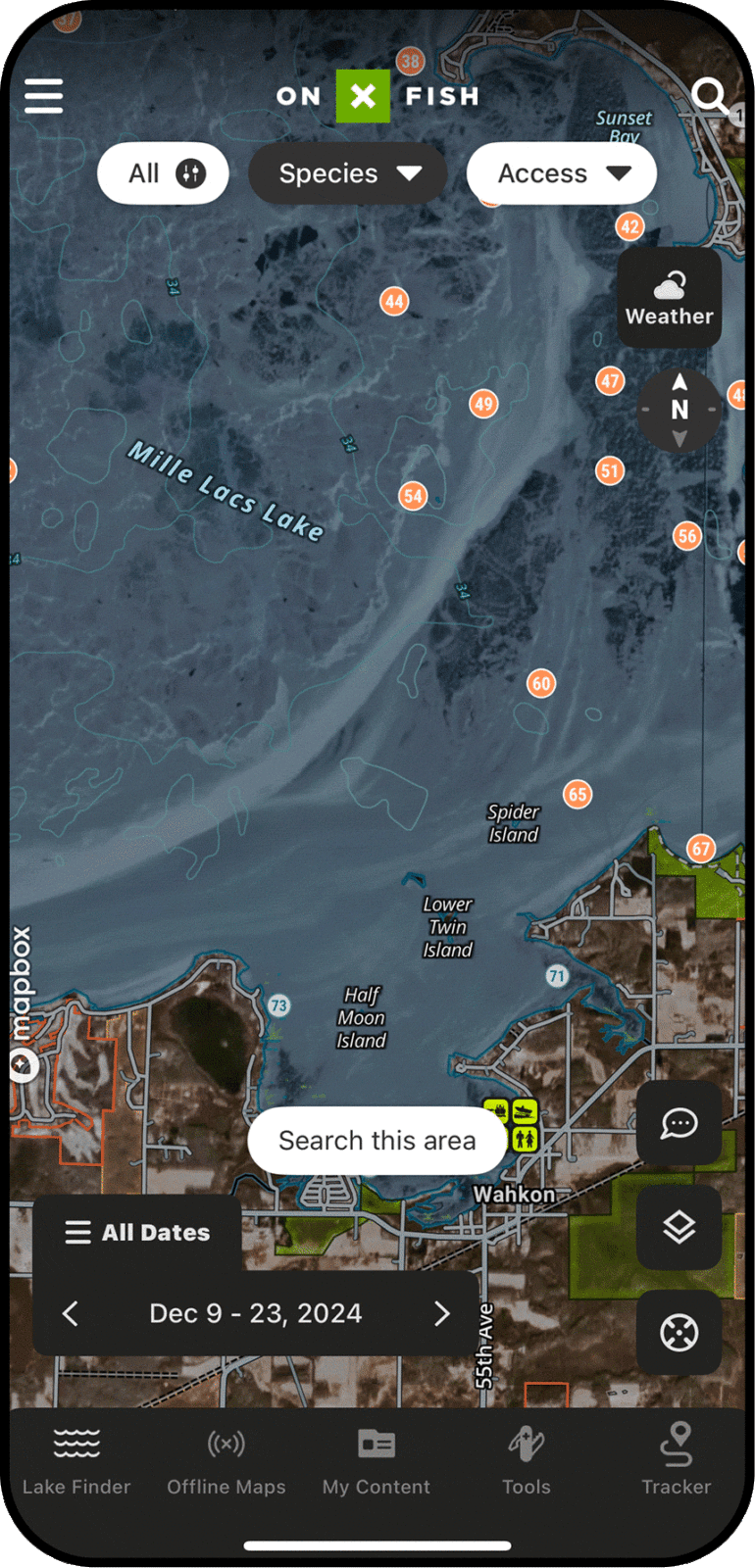
The first step in scouting a lake for ice fishing is studying its underwater structure using contour maps. These maps show depth contours—similar to topographic maps on land—which reveal key features like drop-offs, humps, points, and flats. Understanding how to read these contours allows you to predict where fish are likely to hold based on the species you’re targeting. You can use 3D Lake Maps to visualize those contours more naturally and quickly identify drop-offs, humps, points, flats, and other fish-holding structures before you drill.
Different fish species relate to structure in unique ways. For example, walleye often stage around mid-depth humps or along sharp drop-offs, especially during low-light periods. Perch, on the other hand, may school up in deeper basins or around gradual flats. Knowing these tendencies can help narrow your search and increase your chances of success.
With onX Fish, you can access detailed contour maps to locate these fish-holding zones before you even step on the ice. This not only saves time but also helps you fish more efficiently and safely.
Pro tip: Cross-check several lakes in your area to find the ones with varying combinations of depth and structure for the species you’re after. This approach helps you build a list of high-potential spots before the season even begins, and tests primarily shallow lakes against ones that may be deeper.
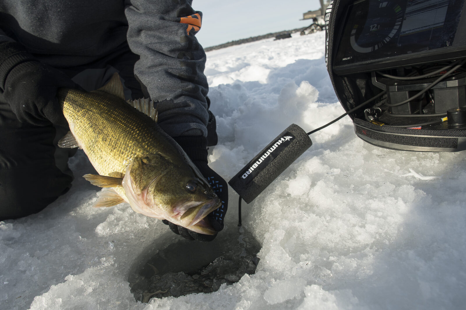
Step 3: Check Recent Imagery for Ice and Access Conditions
Once you’ve identified promising fishing spots using contour maps, the next step is to evaluate current ice and access conditions using Recent Imagery. This satellite imagery provides a recent view of the lake’s surface, allowing you to make safer, more informed decisions before heading out.
With Recent Imagery, you can assess overall ice coverage and identify color variations that may signal changes in ice thickness. Lighter areas often indicate newer or thinner ice, while darker patches could mean slush, open water, or unsafe conditions. You can also spot pressure cracks, heaves, and snow accumulation, which can affect both travel and fishing success.
One of the most valuable uses of this imagery is evaluating shoreline access. Thawing at the shoreline, wet areas, or blocked trails can make entry or exit difficult—or even dangerous. By reviewing these conditions ahead of time, anglers can choose the safest access points and avoid trouble areas entirely. With onX Fish, integrating Recent Imagery into your planning gives you a clear picture of what to expect and helps ensure a safer, more successful day on the ice.
Step 4: Use Historical Knowledge and Waypoints
Combining historical knowledge with current maps is a powerful way to improve your ice fishing strategy. By reviewing data from previous seasons, you can identify proven hotspots, safe access trails, and potential safety hazards that might not be immediately obvious from just one trip. This context helps you make smarter decisions and increases your chances of a successful outing.
Marking these important locations as Waypoints allows you to keep track of key spots throughout the season. With onX Fish, you can save and sync these Waypoints across both mobile devices and desktop computers, making it easy to access your information wherever you are. This seamless syncing ensures you have your most valuable insights right at your fingertips, whether you’re planning at home or out on the ice.
Pro tip: Enhance your planning by incorporating weather overlays and wind data. These factors can influence ice conditions and fish behavior, so taking them into account when choosing your travel routes or fishing locations can improve both safety and productivity.
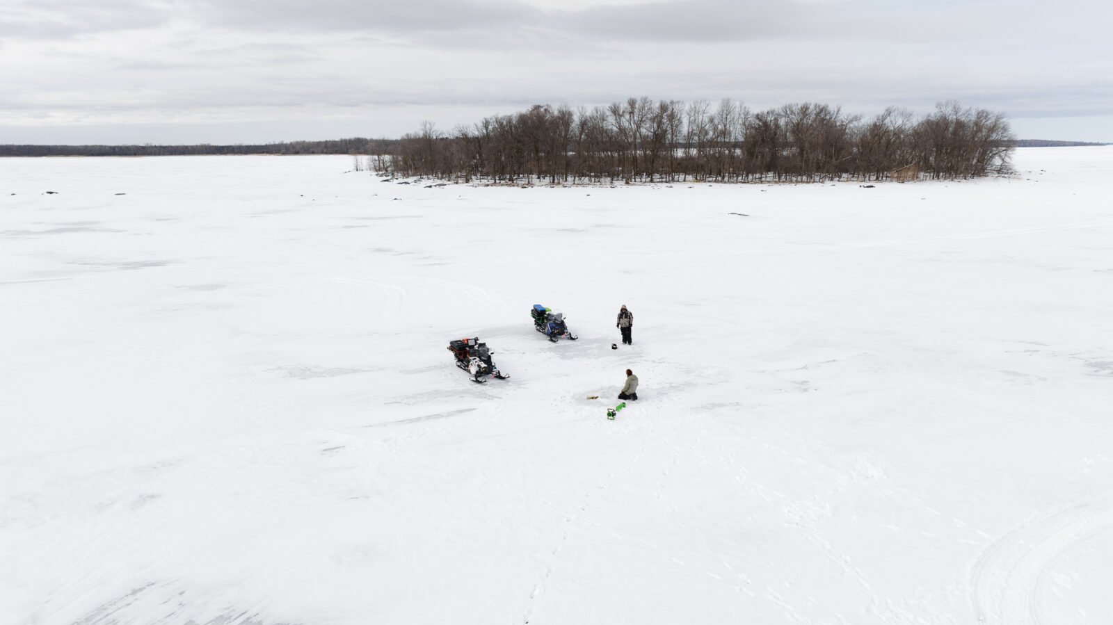
Step 5: Plan Your Route and Navigation With CarPlay
Using CarPlay and GPS navigation can greatly simplify reaching access points and moving between fishing holes on the ice. With CarPlay, your route is displayed right on your vehicle’s dashboard, allowing you to stay focused on driving while keeping track of your location and direction. This hands-free setup enhances safety by reducing distractions and helping you maintain awareness of your surroundings.
Using Tracker, CarPlay, and GPS navigation within the onX Fish App can significantly enhance safety when traveling on frozen lakes and rivers. At the landing, turn on the Tracker feature to trace your updated location as you drive out on safe/known paths. With hands-free mapping, you can view your route directly on your vehicle’s dashboard display, allowing you to stay focused on driving while still keeping track of your location and direction. This reduces the need to handle your phone, minimizing distractions in a potentially hazardous environment. Then, at the end of the day, when dark or in inclement weather, retrace your saved Tracker path to shore. This “breadcrumb” tracking adds an extra layer of security by recording your exact path across the ice. If visibility drops or you need to retrace your route, this feature lets you follow your original track back to safety.
Pairing CarPlay with onX Fish navigation features is especially useful in low-visibility conditions like snow or fog. onX allows you to track and follow safe routes, mark waypoints, and avoid hazards, giving you confidence as you travel across the ice. Together, these tools help ensure you arrive at your spots safely and can find your way back without getting lost.
Pro Tips for Finding New Ice Fishing Lakes
When searching for new ice fishing lakes, consider exploring smaller, less frequented bodies of water. These lakes often see less fishing pressure, which can mean better quality fish and a more peaceful experience. Don’t overlook these hidden gems—they can be some of the most rewarding places to fish.
To evaluate a lake’s potential, combine online stocking reports with onX Fish’s contour maps. Stocking reports provide insight into fish species and population levels, while contours help you understand the underwater structure that attracts fish. Cross-referencing these resources allows you to make more informed decisions about where to focus your efforts.
Additionally, keep an eye on Recent Imagery for signs of vehicle trails or access routes. These clues can help you identify popular entry points and safe paths onto the ice. Using these tips together can lead you to new, productive lakes that others might have missed.
Fish with confidence this winter
Start using onX Fish Midwest today.
FAQs About Scouting Ice Fishing Lakes
Contour maps are ideal for locating underwater structure like drop-offs, humps, and flats where fish tend to gather. Tools like onX Fish offer detailed contour maps to help you find promising fishing zones before you go.
Yes, recent satellite imagery can reveal ice coverage, color variations, pressure cracks, open water, and snow depth. This helps anglers assess current ice safety and plan their routes accordingly.
Look for smaller, less well-known lakes that see less fishing traffic. Cross-referencing online stocking reports with contour maps can help you identify lakes with good fish populations and structure but lower pressure.
Mark Waypoints for access points, safe travel lanes, productive fishing spots, cracks, and any hazards. This ensures you have a reliable navigation plan and can stay safe while on the ice.