onX Fish FAQs
From lake-specific fish data to public access points and bathymetric maps, onX Fish gives anglers the tools to find the right water, every time. Whether you’re chasing trophy bass, planning a weekend ice fishing trip, or scouting new water from home, these FAQs will help you get the most out of your onX Fish membership.
onX Fish is a GPS fishing app (currently available in select Midwestern states) that helps anglers discover new lakes, filter for species, map public access points, and plan trips with confidence.
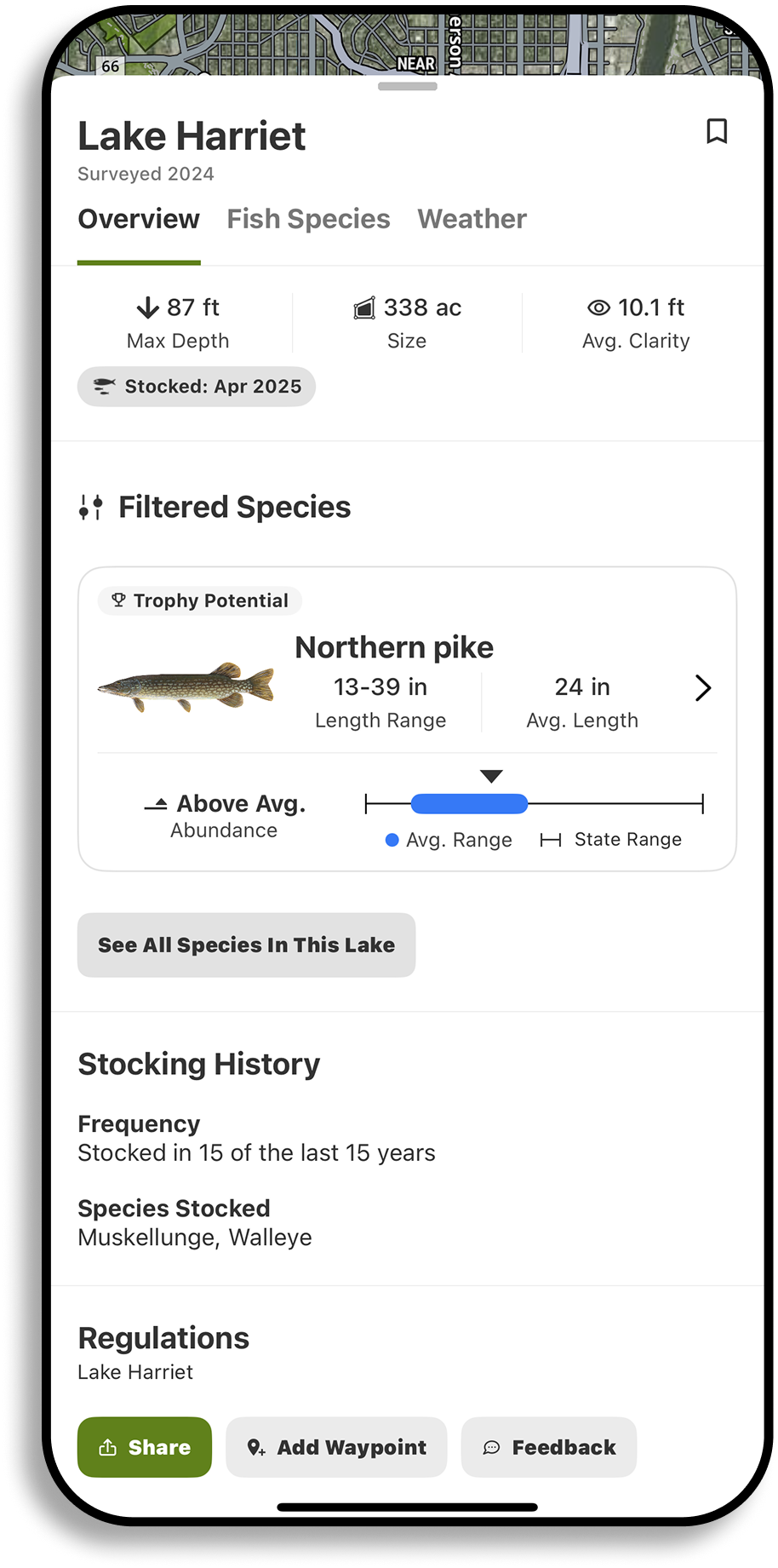
You can search by species, trophy‑potential, keeper fish size, or abundance, view lake bathymetry and recent imagery, check lake and species‑specific fishing regulations, and save maps for use offline—so you’re ready even without cell service.
Yes, onX Fish is free to download, and includes a 7-day free trial of full access to all features. After the trial, you can continue using basic map tools or upgrade to a paid membership for unlimited access to Species Filters, lake details, lake contour maps, regulations, and Offline Maps.
onX Fish offers a 7-day free trial, after which a full membership costs $34.99 per year. This includes access to species and lake filters, fishing regulations, fishery insights, Offline Maps, and more across supported states.
Yes! onX Fish is now available on Android. Download now.
onX Fish is now available on Android. Download today.
Your fishing locations are safe, your data is yours. We use the best standards for data privacy and make every effort to secure your data. We have strict protocols and restrictions in place. Furthermore, we don’t sell your data. We never have, we never will.
To find fishing spots in onX Fish, search by lake name, species, or location, then use filters to narrow results by species type, fish size (trophy vs. keeper), and fish abundance or stocking data. You’ll see detailed lake pages with fishery info, public access points, regulations, and species insights—all designed to help you plan smarter fishing trips.
Yes, onX Fish includes underwater contour lines and lake depth to help you locate drop-offs, ledges, and fish-holding structure. These detailed depth maps are available on hundreds of lakes and can be used with other tools like species filters and Offline Maps for smarter fishing decisions. For a more intuitive view of underwater structure, 3D Lake Maps help anglers visualize depth changes, breaklines, humps, points, and drop-offs before they fish.
Yes, onX Fish lets you drop custom Waypoints to mark boat ramps, honey holes, fishing spots, or your catch locations. You can personalize each Waypoint with icons, notes, and photos, making it easy to track patterns, plan return trips, or share fishing data with others.
Yes, onX Fish displays lake-specific fish species data, including what’s present in each lake, how abundant each species is or recent stocking data, and whether you’re likely to catch trophy-sized or keeper-sized fish. You can filter lakes by species type and target specific fish like bass, walleye, pike, panfish, and more.
Yes, onX Fish works offline when you download Offline Maps while your have a cellular or wifi connection. Offline Maps include lake depth contours, species data, public access points, and fishing regulations for the saved area, so you can navigate and fish confidently without cell service.
onX Fish is one of the best free fishing apps for discovering new lakes, filtering by species, and accessing detailed lake info across the Midwest. It includes a 7-day free trial with access to species data, fishery details, regulations, and Offline Maps, helping anglers plan smarter trips and fish more effectively, even without service.
To manage your onX Fish subscription, log into your account at onxmaps.com, go to My Account → Manage Membership, and from there, you can update billing info, upgrade, or cancel your plan. If you subscribed through the App Store, you’ll need to manage your subscription through your Apple device settings.
Yes, onX Fish shows public fishing access across supported states, including public boat ramps, shoreline access, fishing piers, and nearby public lands. Each lake includes icons for access points and land ownership overlays so you can quickly identify where you can legally and easily fish.
Yes, onX Fish is built for ice anglers, offering tools to help you find productive ice fishing spots and stay safe on the ice. You can use lake contour maps to locate underwater structure like drop-offs, ledges, and mid-lake humps where fish hold in winter. The App also includes species filters, lake-specific regulations, and offline access, so you can scout and fish even without cell signal.
One of the most powerful tools for ice season is Recent Satellite Imagery, which helps you monitor snow cover, shoreline access, and vegetation conditions. This gives you an every-two-weeks view of changing ice environments across the Midwest.
onX Fish is different from other fishing apps because it compiles data from multiple verified sources—including state agencies, satellite imagery, regulation databases, and local experts—and brings it all into one easy-to-use mapping platform. This allows anglers to filter lakes by species, fish size (trophy vs. keeper), abundance, and seasonal conditions, so you can quickly find the exact lake that matches your fishing goals.
Unlike apps that focus on community posts or fishing reports, onX Fish helps you plan smarter trips. It’s especially valuable for ice fishing, thanks to Recent Satellite Imagery that shows real-time changes in shoreline access, snow cover, and vegetation.
Yes, onX Fish is a great tool for planning multi-day fishing trips. You can search and compare lakes using filters like species, fish size, and abundance, then save multiple lakes to explore throughout your trip. Mark Waypoints for access points, boat ramps, campgrounds, or successful spots, and download maps for offline use, so you’re prepared even without service.
Yes, onX Fish is fully accessible on desktop, and offers nearly all the same features as the mobile version, making it a powerful tool for trip planning and research. You can filter lakes by species, view depth contours, check access points, read regulations, and drop Waypoints—all from a larger screen. Everything syncs seamlessly with your mobile app.
onX Fish Midwest is currently available in the following states: Minnesota, Wisconsin, Michigan, North Dakota, South Dakota, Indiana, Ohio, Illinois, Iowa and Missouri—and we’ll be adding more states throughout the year.
The onX Fish App highlights private land that touches or is very close to water you might fish (up to 100 meters). It’s designed to help you quickly see where shorelines, docks, and adjacent banks are private so you can respect landowners and stay legal while fishing. If a parcel is farther than 100 meters from the shoreline, it won’t appear in the onX Fish App.
onX Fish is built specifically for anglers, so it focuses on property that affects fishing access—the land right around lakes, rivers, reservoirs, and coastlines. Our onX Hunt app is designed to show full property boundaries and landowner information across entire parcels to help hunters stay safe and legal, just like how the onX Fish App keeps boundaries water focused to help anglers stay safe and legal while fishing.