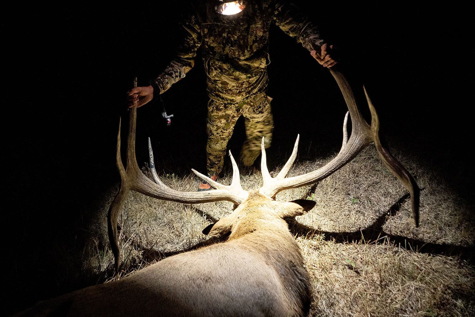
Elk hunting is a dream hunt you’ll find on almost every serious hunter’s bucket list. If you’ve got an elk hunt on the calendar for this fall, we’ve got you covered. Our guide includes what you need to know for your elk hunt, where to hunt, how to find elk, and other elk hunting tips for your season.
TL;DR: Planning an elk hunt this fall? Start by picking a state and strategy, then build your map plan. Top options include Montana, Colorado, Utah, Wyoming, and Arizona—each strong for either opportunity (tags, access, herd size) or trophy potential. Tag draws are getting tighter as non-resident applications surge, so use onX Hunt’s Hunt Research Tools (plus Huntin’ Fool) to target realistic units and back-up options.
E-scout first: Confirm access, pin water (springs/holes), bedding (cool, north-facing timber/benches), feed (meadows, burns 1–10 years old), game trails, pinch points/saddles, and wallows (midday sits in September can be deadly). Stack the puzzle pieces—tags, access, e-scouting, and calling—and your odds rise fast.
Best States for Elk Hunting
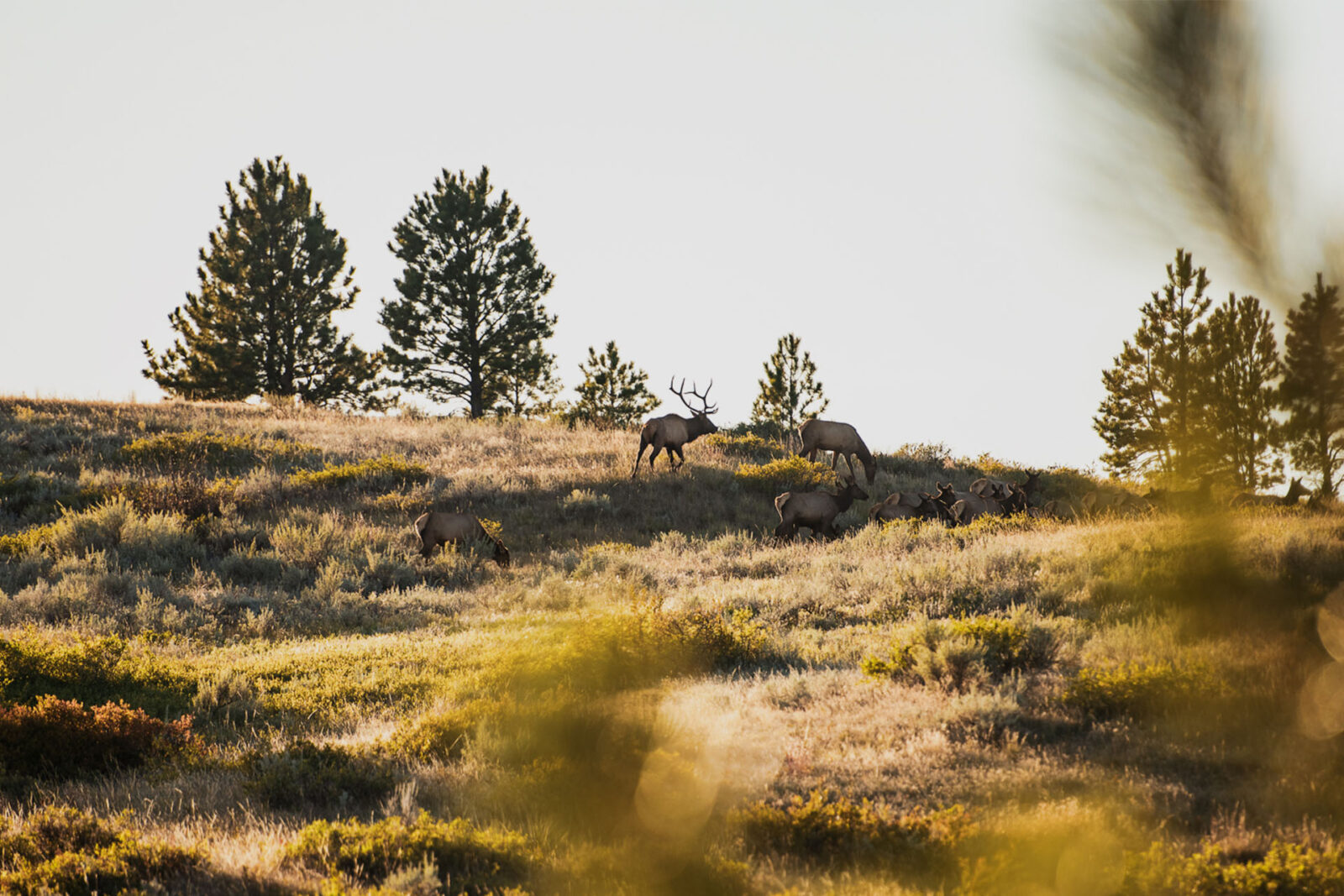
The beauty of elk hunting is largely the majestic landscape these creatures call home. Elk hunting habitat varies throughout the West. States like Montana offer everything from wide open spaces under the big sky to the haunting confines of a dark timber hunt. But not all elk hunting states are created equal.
The #1 Elk Hunting App
Try the Hunt App for Free—and See Your Hunt Season Change.
Hunters should consider a handful of questions as they narrow their search for an elk hunting destination:
- Will it be a bow hunt or a gun hunt?
- Public land or private?
- Can you buy a tag to hunt every year, or will you have to play the drawing system?
- How much hunting pressure will the region receive?
- Do you have the means of commuting into the backcountry (legs, horse, ATV)?
Answering these questions will likely help you narrow down your search. And chances are, your search will take you to one of our top 5 elk hunting states.
What are the 5 best states for elk hunting? In no particular order, here’s a look at some of the best bets for your next elk hunt.
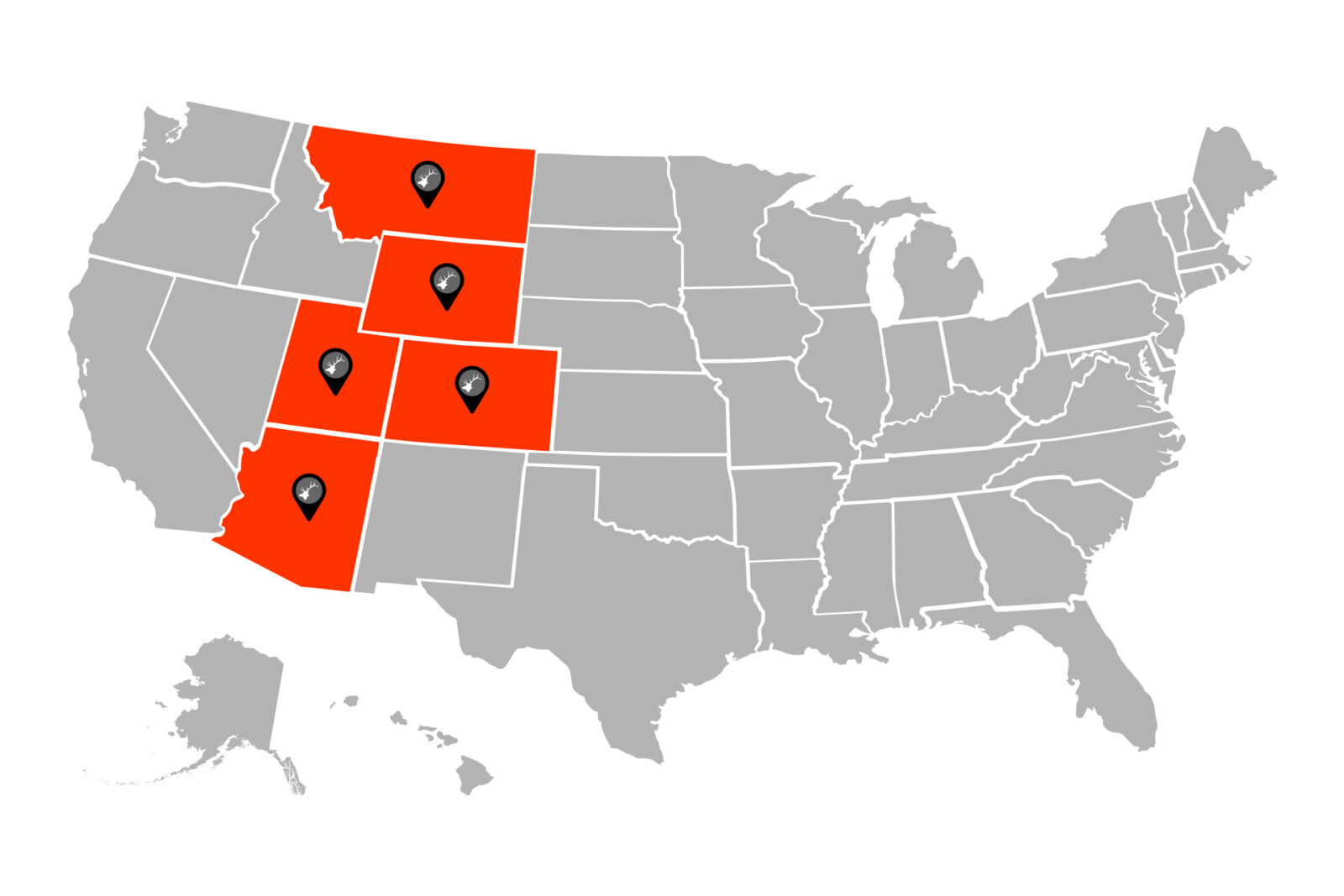
Montana
Despite seasoned hunters claiming Montana’s elk hunting glory days are over, it remains the premier destination for elk hunting with abundant opportunities. Of the top 50 typical bulls ever taken, 10% came from Montana, and the state features extensive public land access for all.
Colorado
Colorado is known for its quantity of elk as well as for holding trophy-sized bulls. It is home to the largest elk herd in the U.S. at about 300,000 elk. And, because of its central location, Colorado is a prime destination for non-resident hunters from the eastern U.S.
Utah
For hunters seeking a trophy elk adventure, Utah is the ideal destination with its impressive bulls, ranking just behind Montana for record typical bulls over the past decade. Utah is also in the top three states for typical and non-typical bulls combined.
Wyoming
For quality elk hunting opportunities, Wyoming’s non-resident (NR) elk tags come one of two ways: 60% of non-resident tags are in the general draw pool with $692 base fee, but the other 40% of NR tags require a $1,258 drawing fee plus the base fee ($1,950 total).
With plenty of big bulls, Wyoming ranks just behind Utah for combined typical and non-typical bull harvests and is home to roughly 110,000 elk, making it an excellent destination for your first or next elk hunt.
Arizona
If your goal is tagging a trophy bull elk, Arizona, with some of the largest typical and non-typical bull elk, should be on your shortlist. Though, drawing a tag is challenging, with non-residents limited to no more than 10% of tags. Increase your odds by considering a late season archery or rifle hunt.
Elk Draw Trends
Destination hunts are more popular than ever. Comparing resident applicants to non-resident applicants, you’ll discover that non-resident applicants are the fastest-growing segment.
An increase in hunter numbers is great for the local economy in elk hunting states, but it can make your odds for a successful draw a bit of a challenge. In fact, many hunters have become increasingly frustrated with their inability to draw their desired elk tag year after year.
A closer look at elk draw trends gives insight into what hunters can expect when it comes to competition for tags.
With the increasing need for elk hunters to develop a strategic hunting plan, savvy hunters will take advantage of onX Hunt features such as Hunt Research Tools and Huntin’ Fool. Using Hunt Research Tools, hunters get accurate and complete information as they navigate application season.
E-Scouting for Elk
A successful hunt starts with ample preparation. E-scouting is the art of planning your hunt, becoming familiar with terrain, and learning the behavior patterns of your prey. Modern scouting is divided into two phases, e-scouting with technology and old-fashioned “boots on the ground” scouting.
What are the key features you should be looking for when e-scouting? Below you’ll find a short list of the top Waypoints you should add to your map as you e-scout for elk.

Access
Access is the key to opportunity in elk country. You can find the hottest-looking sign and terrain features for elk, but if you don’t have access, you’re moving on to Plan B. Fortunately, confirming access is easy with the onX Hunt App.
You can confirm public and private land opportunities, pinpoint where you’ll need to park, decide whether you’ll be camping at the gate or hiking in to set up camp, map out your access routes to potential hunt areas, and study road and trail systems in the area. There’s a wealth of information to be gained ahead of time when it comes to discovering access details through e-scouting.
Our friends at Huntin’ Fool share several tips for assessing access:
- Use the Roads, Trails, & Rec Map Layer: Looking at Topo and Aerial Basemaps can help identify both trails and roads. Head to Hunt Map Layers and turn on the Roads, Trails, and Rec Map Layers. You can tap into roads for more information, or follow the road along its path to make sure it looks passable.
- Always Have Plans A, B, C, D: With backcountry hunting gaining traction, some hunters have shifted to “mid-range” spots—areas somewhere between where you’ll find road hunters and the backcountry crowd. Though, this isn’t something you can determine until you show up at your access point. If there are camps set up at the trailhead, then you can figure those people are hunting nearby (and you therefore might have more luck hiking deeper). On the other hand, if you see horse trailers, you’re probably not out-hiking those groups. Develop several access strategies while e-scouting so you can pivot in the field.
- Rise Above the Rest: Use the Topo Basemap to find “hidden” benches in areas that are steeper and might keep other people from accessing them. Don’t be afraid to get off the beaten path and climb 1,500 feet of vertical to get to an area that looks good to you.
- Pinpoint Your Camping Spot: If you’re packing in for a hunt and planning to stay in the mountains, use the Topo Basemap to find a good flat spot for your campsite. Also, look for any water source close to the camping area in hopes you can use it to filter water.
With backcountry hunting gaining traction, some hunters have shifted to “mid-range” spots—areas somewhere between where you’ll find road hunters and the backcountry crowd.
Water
Water is another key element that must be present to hold elk in an area of interest. Your Basemap allows you to easily identify creeks, ponds, and other waterholes that elk are likely to frequent on a daily basis.
Drop a Waypoint on these water sources as you e-scout. Once you put boots on the ground, you can move from point to point to confirm whether elk are using the water source.
One word of caution, though, from Huntin’ Fool: Springs and ponds can go dry in drought years, so never be surprised if you show up to a spot you had pinned, only to find a dirt hole.
Bedding Areas
Especially during archery elk season, elk are typically more active at night, early morning, and late evening, and then tend to bed down for the day. Key in on areas with heavy timber that provide lots of cover. Though elk can bed anywhere, many hunters prefer to start with north-facing slopes because they provide cool, dark timber, plenty of bedding cover, and security.
Use the Topo Basemap and 3D Mode to identify benches that could be used as a good bedding area. And, keep in mind that thermals will be going up during the day as the heat rises, so elk prefer to bed closer to the ridgetops where they can smell anything approaching from below.
Feeding Areas
Focus your e-scouting efforts on potential feeding areas in open parks and meadows, burns, or south-facing slopes. Elk will likely move down into low-lying meadows in the evening to feed throughout the night, before heading back up into cool cover for the day.
Our friends at Huntin’ Fool say they sweat finding feeding areas the least. Reason being that if an area has water, it probably has feed. Turn on the Historic Wildfire Map Layer (find it under Hunt Map Layers → Trees, Crops, and Soil) and look for burns between one and 10 years old. Not likely to be overgrown, these burn areas provide excellent elk forage.
Look for agricultural fields, too. Though most ag fields will be private property, elk will often travel miles to these locations, allowing you to intercept them as they travel to or from fields.
Turn on the Historic Wildfire Map Layer (under Hunt Map Layers → Trees, Crops, and Soil) and look for burns between one and 10 years old. Not likely to be overgrown, these burn areas provide excellent elk forage.
Games Trails
When e-scouting, locating game trails can help you locate elk. Switch to the Satellite Basemap, zoom in on pinch points and saddles, and see if you can see trodden-down paths. If you find one, follow the trail to see where it starts and ends.
And, if you stumble onto an old game trail when you’re in the field, consider turning your Tracker on as you walk the trail. Having the trail documented might come in handy later on during a hunt when you need to maneuver efficiently and quietly. Though, of course, if it’s obvious you’ve found an active game trail (fresh hoof prints, etc.), then you might be better off steering clear of the path so you don’t scare the elk off with your scent.
Scouting for Elk
The big advantage for resident hunters is the ability to put boots on the ground for pre-season elk scouting. While non-resident hunters are limited to e-scouting, locals can get the edge with time spent in the backcountry in the days, weeks, and months before the opener.
So what should hunters be looking for when scouting for elk? The list below includes the hot features you’ll want to find and log into your phone as you vet your game plan for opening day.
Waterholes/Wallows
This just might be your greatest scouting discovery of the season, particularly for early-season elk hunting. Find an active waterhole, muster up plenty of patience, and you might find yourself in the perfect place for an early-season ambush. During archery elk, wallows can be a great spot to set up midday in hopes a bull decides to take a roll in the mud. Bulls will frequent wallows during the rut to mark their territory. When scouting, flip to the Satellite Basemaps and slowly move across the screen looking in the bottoms of draws or nearby springs for small dark patches of ground (read: look for mud).
Pinch Points
It’s important to drop waypoints and pins on the terrain features that funnel elk. Saddles (the low point between two high points), drainage connectors, ridge crossings, and heavily used trails all indicate where you might encounter a bull this fall. Locate and log these features into the onX Hunt App.
Bugles
Add a Waypoint when you hear a bugle, and you’ll quickly notice the local herd’s routines. After opening day, Waypoints can also help you keep tabs on where you are in relation to the bull as you move in for the shot. In the past, hunters would use a tree, rock outcropping, or other landmark to keep track of where they were and where they needed to be. These days, onX lets you know where you stand—as well as where you need to be.
Archery Elk Hunting Tips
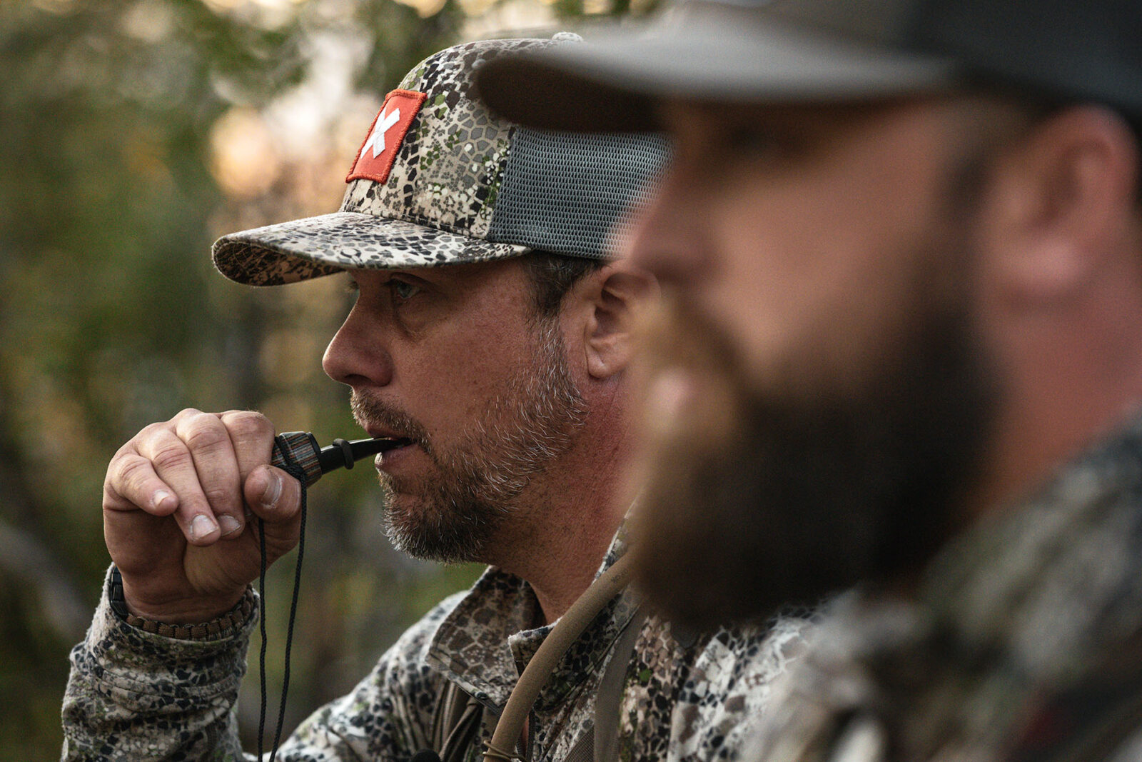
Elk Calling Tips
The opportunity to communicate with a bugling bull by calling during the early season is easily the best part of September hunts. It’s what elk hunters live for. But there’s more to bringing a bull into bow range than rippin’ off a bunch of random cow calls and bugles. Hunters would be wise to develop an elk calling strategy for success when they go head-to-head with a bull this fall.
Take Their Temperature
Knowing the attitude of a bull can go a long way when deciding how much, or little, you should be calling. What call is he responding to hot and fast? What sound seems to shut him down, or cause him to go back to his cows? Don’t miss his responding body language and vocalizations here. Pay close attention, and he’ll tell you what he wants to hear.
Keep It Real
Some of the deadliest calling sounds you can make don’t come from the call in your mouth. Think about the sounds you hear from a herd of elk. There are sticks breaking, rocks popping, hooves stomping, and more. Use these sounds to keep it real this season. Don’t be afraid to crack rocks together and bust brush to mimic the sound of a rutty bull.
Play Hard To Get
Like a lot of other creatures in the wild, elk were designed with incredibly keen senses. Their ability to pinpoint your calling location is nothing short of amazing. But that’s also why hunters often struggle with a bull that refuses to close the deal and walk within bow range. In many cases, these hunters set up in the wide open, and any approaching bull should easily be able to see the sound of the cow he just heard. When he doesn’t, it’s usually game over.
The key is to make him come find you. Make sure your calling setup includes some cover, a roll in the ridgeline, or any other barrier that will require an approaching bull to close the distance as he comes to look for you. Wide open spaces are beautiful, but rarely are they the ideal setup to get a bull in bow range.
Get In Tight
Elk make a lot of noise. Whether it’s raking trees, bugling, or cow sounds, there’s a lot going on within the herd. For this reason, hunters can often slip and sneak their way to within striking distance of a bull, or at least throw out that final call that the boss bull simply can’t ignore. Bulls won’t tolerate the threat of another bull in tight. Break into his “bubble,” and hit him with a bugle. Just be ready. He’s likely headed your way.
Some of the deadliest calling sounds you can make don’t come from the call in your mouth. Don’t be afraid to crack rocks together and bust brush to mimic the sound of a rutty bull.
Late Season Calling
Don’t think calling is limited to just the early season. If you’ve still got a tag in your pocket late in the season, don’t hesitate to try calling to bring elk from the timber for a shot. Soft and subtle cow calls can be just what a bull needs to hear to elicit a response. Just remember: Less is usually more when calling elk in the late season.
Final Thoughts
Make the most of your elk hunting season with the practical information mentioned above. The tools, planning, preparation, e-scouting, and calling skills are all pieces of the puzzle that ultimately lead to success.
Shoot your weapon, gather the gear, study your onX Hunt maps, and sharpen your knife. Elk season won’t be long now.
FAQs About Elk Hunting
Top five to consider:
- Montana – Big public access + consistent quality.
- Colorado – Largest herd; broad opportunity for residents and non-residents.
- Utah – Elite trophy potential; strong B&C history.
- Wyoming – Quality hunts; general vs. special non-resident structure.
- Arizona – Premier trophy bulls; tough draw, consider late hunts.
Draws are more competitive, especially for non-residents. Improve odds by: Applying to more units, considering late or less popular seasons, building points where applicable, and using Hunt Research Tools to find units with realistic odds.
Sit active wallows/waterholes midday and call sparingly around bedding. Morning/evening, work travel corridors between bedding and feed.
Many of the filters on onX Hunt will be helpful while e-scouting or in the field:
- Hunt Research Tools: Draw odds and unit intel.
- Public/Private Lands Layers: Plan legal access.
- Wildfire Layer: Find productive burns.
- 3D + Lidar Maps: Read benches, saddles, and north slopes.
- Waypoints and Tracker: Mark bugles, wallows, routes; share with partners.
- Offline Maps: Full nav without service.
KNOW WHERE YOU STAND
Find public and private land with onX Hunt and know where you stand, no matter what state you hunt in.