Taum Sauk Cemetery - RCR 205
Total Miles
0.4
Technical Rating
Best Time
Fall, Summer, Spring, Winter
Trail Type
Full-Width Road
Accessible By
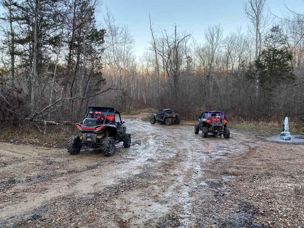
Trail Overview
Taum Sauk Cemetery, or the Reynolds County Road 205, is a remote coarse gravel road in Reynolds County, Missouri. The cemetery road comes off the unnamed paved Reynolds County Road that forks from the Reynolds 204, heading north into the valley bottoms south of Proffit Mountain, which hosts the (Ameren-owned) Taum Sauk Hydro-Electric Power Plant upper reservoir. These bottoms and the Reynolds CR 205 closely rest next to the Taum Sauk Creek. Despite not seeing the water from the road, the creek's influence is shown in the terrain as the road is consistently made up of coarse natural creek gravel that has simply been graded by the county, occasionally having spots that fade to dirt. The road ultimately leads to the peaceful and remote Taum Sauk / Pinkley Cemetery, where there is a parking area with plenty of room to turn around. The cemetery graves are surrounded by a fence with a few entry gates. Please be respectful to those who came before us, and leave the cemetery as, or better than, you found it.
Photos of Taum Sauk Cemetery - RCR 205


Difficulty
Taum Sauk Cemetery is given a base rating of 1/10 for being generally a semi-well-maintained road of natural, dirty coarse gravel in Reynolds County. There is also a small potential for water collection spots and surface mud on the road during wet conditions, with potential flash flooding in extreme scenarios. It is safe to expect the normal gravel road complications, such as washboards, potholes, mounding of the gravel, and potential spots where the gravel fades to dirt. Difficulty could increase in seasons of extreme inclement weather, lack of maintenance, and heavy use, but would likely drop back to 1/10 difficulty once dry, or as soon as it would be mended.
History
The Taum Sauk Cemetery, also known as Pinkley Cemetery, is the final resting place of over 55 lives who lived between 1823-2021(Current as of 2025). Please respect those who came before us, leave the Cemetery as or better than you found it. --- In 1953, Union Electric (Simply UE) began looking for a potential site to build a pump storage facility, and by 1958 had set its focus on the St Francois Mountains due to the large elevation changes of the area, being over a 300-foot elevation drop they looked to have at the head. At first the surveying agency recommended Taum Sauk Mountain as the first choice for construction, but strong political pushback of Taum Sauk being the highest point in Missouri and a very scenic mountain, led UE to seek a different spot, ultimately leading them to Proffit Mountain, being similarly elevated and having much more than the 300-foot elevation drop needed for the head of the plant, with beneficial proximity to the East Fork Black River and a terminal of the electric grid. In 1960, construction began at Proffit Mountain to build the then one-of-a-kind Pumped Storage Power Plant. The unique design involved constructing a man-made circular dam, forming a lake of roughly 54 surface acres, with its perimeter being made of 100-foot-tall walls, holding a potential 1.5 billion US gallons of water, as well as buillding another dam to impound the East Fork Black River to create the lower reservoir lake to pump water in and out of for a daily cycle of the water. By 1963, UE had completed the rockfill embankment, lined on the inside by concrete panels to keep it water-tight, along with the 7000-foot tunnel bored through the hill down to the two reversible turbines along the lower reservoir lake. Commissioned on December 20th of 1963, it went live for the first time, with each turbine generator able to generate 175 megawatts of electricity, being the largest of its type produced at this time in history, as well as the plant being recognized as the largest pump storage facility in North America in several distinguishing factors, like head and capacity. In 1972, the turbines were upgraded to 204 megawatt units. In December of 1997, Missouri's UE and Central Illinois Public Service Company (CIPSCO Inc.) merged to form Ameren, which manages the Taum Sauk pump storage to this day. Again in 1998-1999, the turbines were upgraded to larger 225 megawatt units, giving a total of 450 megawatts of output. In early 2004, minor leaks were found coming from the upper reservoir, to which a collection pool was made to collect and pump water back into the reservoir temporarily, ultimately leading to a liner being installed on the inside of the reservoir in September-November of 2004. In September of 2005, a plant superintendent noted that waves of water had been forced over the Northwest wall by winds from Hurricane Rita, later followed by notes saying that the pool level gauging equipment had begun to malfunction and was unreliable to measure water levels on the upper reservoir. On December 14th, 2005, the primary gauging system failed to stop filling water into the reservoir, with water pouring over the same section of the northwest wall (as in September 2004), leading to quick erosion of the embankment, followed by a catastrophic failure. This sent a 20-foot-tall surge of water 1.75 miles downhill to roughly the Johnson Shut-Ins State Park along the East Fork Black River, ultimately dumping 1 billion gallons in total over 12 minutes. Luckily, the State Park was closed for winter, and only had the Superintendent and his family on site at the time of the major flooding, easily pushing the structure with the water's sheer power. All 5 family members survived, suffering only minor and moderate injuries, and were treated at a local hospital. This event led to several litigation actions and investigations into the cause of the event. Ameren admitted fault for improper maintenance of the pool level measurement equipment, settling with the Park Superintendent and with Reynolds County, after a Judge ordered Ameren to pay 180 million in damages. Ultimately, this led to the rebuilding of the upper reservoir dam from the ground up with a new roller-compacted concrete design, which was eventually completed, recertified, and reopened in April of 2010, becoming the largest roller-compacted dam in North America. In 2014, the complete renovation of Johnson Shut-Ins State Park was completed. As of December 2025, the site is still locally talked about both in legend and myth, with concern and marvel at the sheer power that is being contained and manipulated within the land and walls of the Ameren Taum Sauk Pumping Storage Plant. When spending a day on the lower reservoir lake, visitors can witness the water visually at its lowest pool level until around 2 PM and then rapidly rise back up to high pool level at 7 to 9 PM, only to be dropped again by 9 AM the next morning, roughly a 12-foot fluctuation cycle. Documented By Christopher Menz 12/2025
Status Reports
Taum Sauk Cemetery - RCR 205 can be accessed by the following ride types:
- High-Clearance 4x4
- SUV
- SxS (60")
Taum Sauk Cemetery - RCR 205 Map
Popular Trails
Pine Union Hill FSR 2137
Coon Hollow - FS 2482

Copperhead 295
The onX Offroad Difference
onX Offroad combines trail photos, descriptions, difficulty ratings, width restrictions, seasonality, and more in a user-friendly interface. Available on all devices, with offline access and full compatibility with CarPlay and Android Auto. Discover what you’re missing today!