There’s so much more to soil than meets the eye. As hunters, we should be aware of what’s beneath the surface in the literal sense to be better-informed whitetail hunters.
How does soil impact deer hunting? Our terrestrial environments depend on soil to maintain plant life. If an ecosystem has healthy plants, it has healthy forage for deer. Whether you’re scouting for areas with exceptional natural food sources or looking to lay down a few food plots, it all starts with knowing what soil class lies beneath.
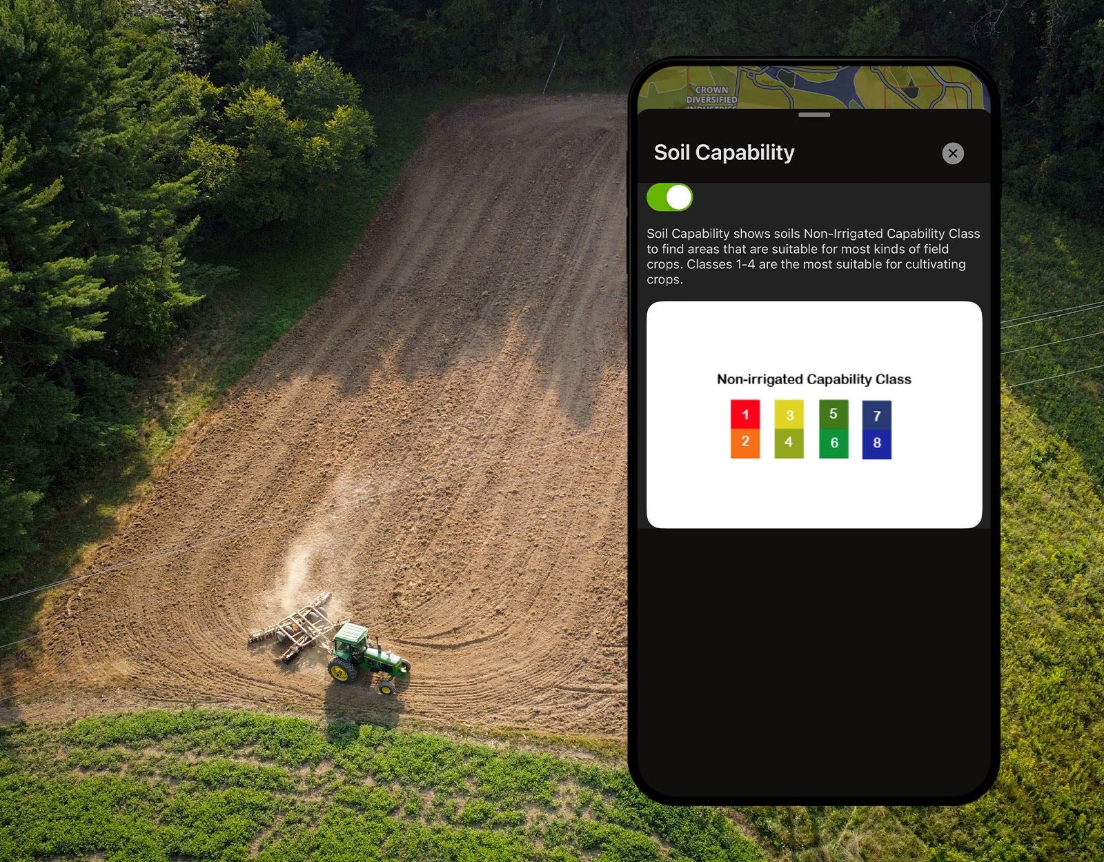
With onX Hunt’s Soil Capability Map Layer, Elite Members can access Soil Web Survey insights in-app. Watch the video below for a quick tour of how the Map Layer shows Soil Non-Irrigated Capability Classes, which helps you understand the soil’s suitability for different uses, such as pasture, cropland, rangeland, forestland, or wildlife habitat.
Soil Classification
Soils are broadly grouped into eight land capability classifications, which shed light on the soil’s ability to host common field crops. The lower the number, the more suitable the soil is for crops. The exact definition of this Capability Classification is “a system of grouping soils primarily on the basis of their capability to produce common cultivated crops and pasture plants without deteriorating over a long period of time.”
There is a key distinction between soil classifications and soil types (or textures), which we’ll cover shortly. But the thing to know is that understanding the Non-Irrigated Capability Class will show you a soil’s natural (i.e. non-irrigated) suitability for most common types of field crops, which has more factors involved than just a soil’s texture. Essentially, the classification system tells you how good land will be for planting crops that can attract wildlife.
The classification system tells you how good land will be for planting crops that attract wildlife.
Let’s consider the eight soil classifications you’ll find in the Hunt App and what they mean.
(Non-Irrigated) Land Capability Classifications
- Class 1 – Soils have slight limitations restricting their use. Translation: Class 1 soils are the most fertile and you’ll be able to grow nearly any kind of crop.
- Class 2 – Soils have moderate limitations restricting plant choice or requiring moderate conservation practices. Translation: Not all plants may thrive in Class 2 soils, so you’ll have to choose the right types or make slight changes to the land (e.g. amendments, irrigation, etc.) to help plants grow.
- Class 3 – Soils have severe limitations restricting plant choice, requiring special conservation practices, or both. Translation: If trying to grow in Class 3 soils, choose plants carefully and manage the land (e.g., irrigation, amendments, etc.) to support success.
- Class 4 – Soils have very severe limitations restricting plant choice, requiring very careful management, or both. Translation: Your Class 4 soil likely won’t cultivate crops without concerted land management practices.
- Class 5 – Soils are subject to little or no erosion but have other limitations, impractical to remove, that restrict their use mainly to pasture, rangeland, forestland, or wildlife habitat. Translation: Class 5 soils could make planting unfeasible.
- Class 6 – Soils have severe limitations that make them generally unsuitable for cultivation and restrict their use mainly to pasture, rangeland, forestland, or wildlife habitat. Translation: Class 6 soils are likely to make planting unfeasible.
- Class 7 – Soils have very severe limitations that make them unsuitable for cultivation and restrict their use mainly to grazing, forestland, or wildlife habitat. Translation: Class 7 soils make planting unfeasible.
- Class 8 – Soils and miscellaneous areas have limitations that preclude commercial plant production and restrict their use to recreational purposes, wildlife habitat, watershed, or esthetic purposes. Translation: Class 8 soils make planting unfeasible.
Why Soil Is Important for Hunting
Once you consider that soil, with its unique minerals, determines the types of flora and fauna that can thrive in an area, you’ll quickly see the connection between soil type and the types of wildlife that feed, walk, bed, and breed on it.
For whitetail hunting, deer are looking for two primary things in any given area: food and habitat/cover. Without both, or at least a whole lot of one, fewer deer will inhabit an area. The soil determines which plants, mast, forage, tree cover, and nuts/seeds/fruit can grow. This is why hunters pay attention to soil.
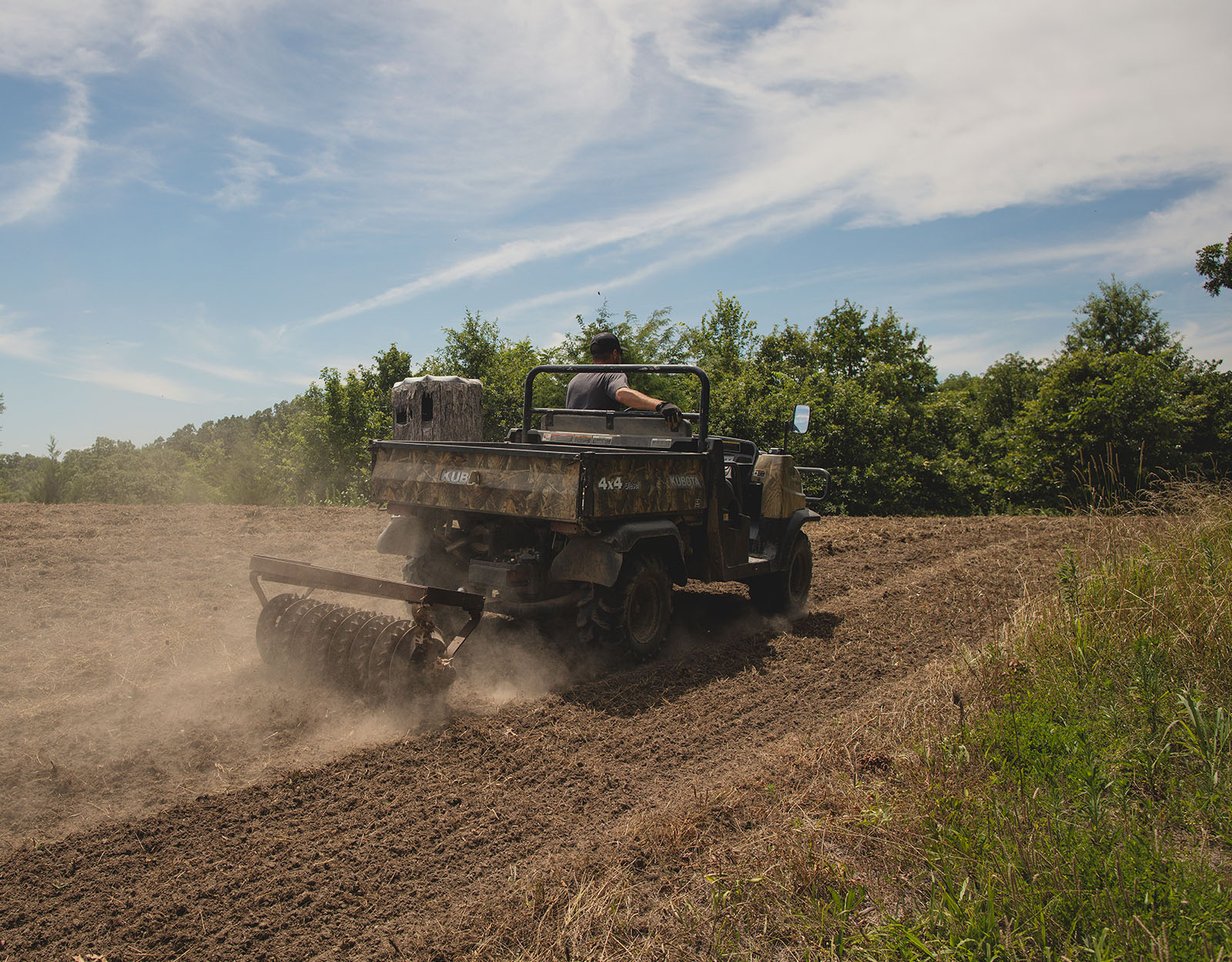
The most obvious and biggest use case for understanding soil capability is food plot planning. The difference between Class 1 soil and Class 3 soil will determine whether you can plant straight away, need to lime or fertilize first, or will be limited to planting red pines for cover instead of red clover for grazing.
The biggest use case for soil capability is planning food plots.
Understanding soil classification is also useful for scouting potential natural food sources. From big game to bird hunting, if you find a game’s food source you will likely find the game. If you see soil unsuitable for most types of forage, you might avoid those areas; conversely, if you see farmlands on fertile grounds, you might want to knock on that farmer’s door to ask permission to hunt there.
When thinking holistically about soil as a hunter, you might not only consider what can be planted there but also what might already be living there. As one example, a woodcock’s diet is made up of 95 percent earthworms, as they are high in protein and fat. Earthworms prefer silty soils with a high water-holding capacity (75% of a worm’s weight is water), and though they can tolerate soils with a pH between 5.0 and 8.0, they prefer soils with neutral pH (7.0). Find that soil and you increase your chances of finding woodcock.
A Note on Soil Texture
We just gave an example of woodcocks loving to eat earthworms and earthworms preferring silty soils, so how does that play into the onX Hunt Soil Capability Map Layer? The Map Layer is color-shaded according to the eight defined Land Capability Classifications, and when you tap on a shaded area, you will find the soil type (i.e. texture) in the info card that pops up. This will give you that extra piece of information to stitch together the right soils for plants and animals in a given area.
To further your knowledge of soil texture, we need to cover some soil basics. Soil is composed of combinations of soil particles, including sand, silt, and clay. The proportions of each particle determine the soil’s texture, or what many people think of as soil type. Here’s how soil particles and textures make up the common soil types.
Soil Particles:
- Sand: Coarse and gritty, drains quickly, and does not hold onto nutrients as well as other particles.
- Silt: Smooth, like flour, and retains water better than sand.
- Clay: Sticky when wet and holds nutrients well but has poor drainage.
Soil Textures:
The United States Department of Agriculture (USDA) recognizes 12 soil textures. These are the soil types you will see listed in the pop-up when you select a color-shaded section of the Soil Capability Map Layer:
- Sand
- Loamy sand
- Sandy loam
- Sandy clay loam
- Loam
- Silt loam
- Silt
- Silty clay loam
- Clay,
- Clay loam
- Sandy clay
- Silty clay
The Map Layer is color-shaded according to the eight defined Land Capability Classifications, and when you tap on a shaded area, you will find the soil type (i.e. texture) in the info card that pops up.
While it’s important to note again that non-irrigated soil capability classifications are different from soil textures, the two can paint a more detailed picture of a land’s potential for crops. To see how they might work together, here are some broad basics on cropland suitability based on soil textures:
- Sandy soil can be good for root crops like carrots and parsnips, as well as shrubs, bulbs, lettuce, and berries. Sandy soil is not the best match for brassicas, peas, or beans.
- Clay soil can be good for corn, peas, fruit trees, leafy crops, and many perennials. Clay soil is not the best match for root vegetables or delicate berries.
- Silty soil can be good for most vegetables, shrubs, grasses like wheat and rye, corn, and perennials like strawberries. Silty soil is not the best match for root vegetables. But it’s great for earthworms.
- Loam is widely heralded as the best agricultural soil due to its even balance of particles. Loam is favorable to most crops.
Bringing Soil Capability Maps In-App
The Soil Capability Layer displays Non-Irrigated Capability Class because it gives a potential food plot planner or whitetail hunter looking to scout fertile hunting spots a comprehensive picture of the land.
Soil Capability Map Layer Data
Using information from the USDA Natural Resources Conservation Service (NRCS) Gridded Soil Survey Geographic (gSSURGO) Database, which may be familiar to those who routinely dig into Web Soil Survey Reports, a Capability Class considers important soil quality factors, such as slope gradient, whether the area is prone to flooding, and erosion, to define the land’s suitability for crops. In other words, the Soil Capability Layer gives you more information than just what soil type is present.
The USDA updates its source data around the first week of July annually. You can expect the Hunt App to reflect yearly updates shortly after that. If you’re exploring the Soil Capability Map Layer in the Hunt App and you notice an area without soil data, this means USDA has potentially not surveyed the area yet.
Using information from the USDA NRCS gSSURGO Database, which may be familiar to those who routinely dig into Web Soil Survey Reports, a Capability Class considers soil quality factors, such as slope gradient, whether the area is prone to flooding, and erosion, to define the land’s suitability for crops.
Using the Soil Capability Map Layer
An Elite Member feature, Soil Capability is available on Web, iOS, and Android and is found under “Trees, Crops, and Soil” within Hunt Map Layers.
With the Soil Capability Map Later turned on, you will see a color-coded map, ranging from dark green (least conducive to planting) to dark red (most conducive to planting).
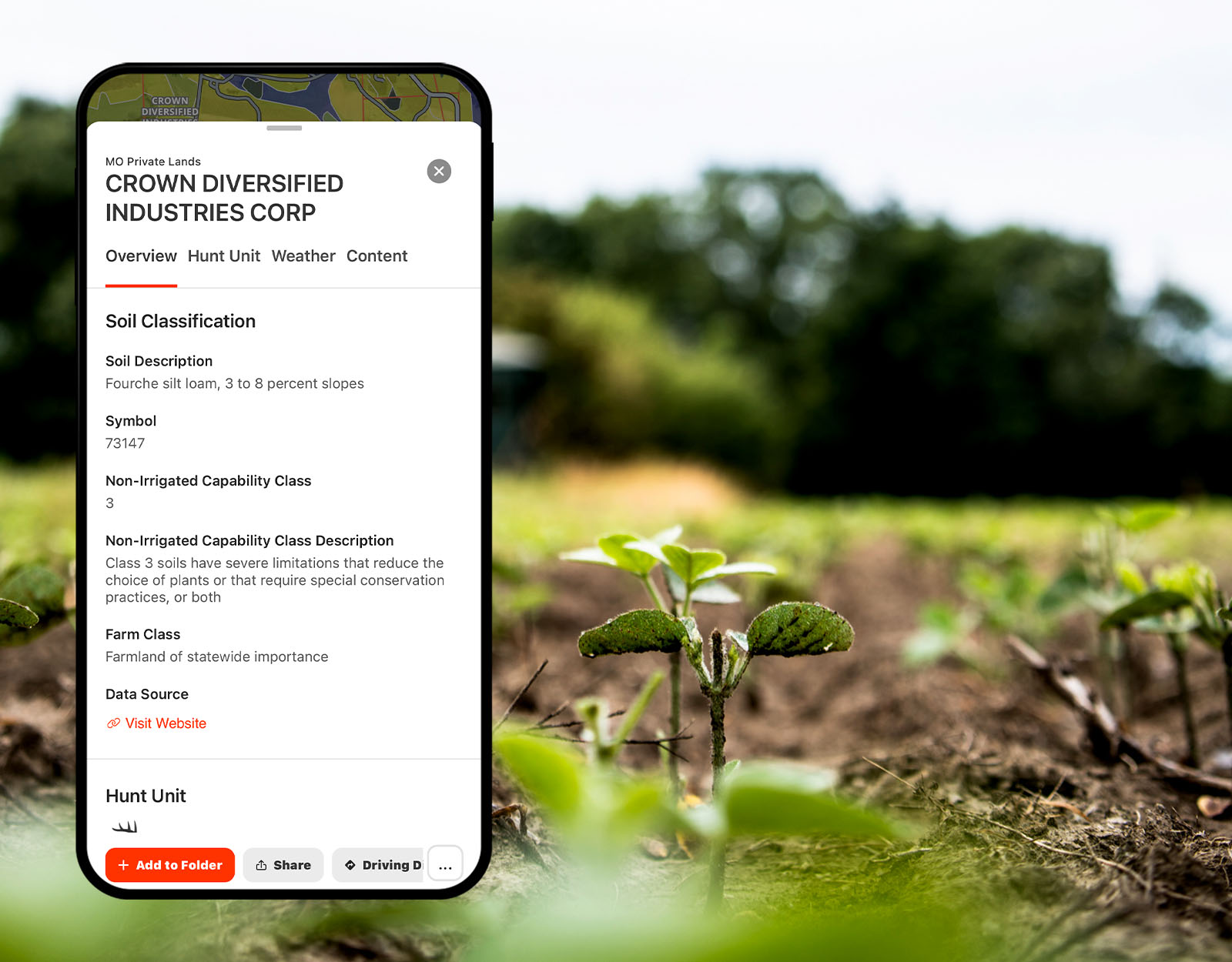
When you tap on a color-shaded area, a tile will appear. Under the section “Soil Classification” you will find multiple soil insights, including:
- Soil Description: Provides information about the soil series, soil textures, and topographical context.
- Symbol: Shows the soil map unit information from the soil survey. Each letter or number in the symbol provides specific details on the soil. The first two letters usually represent the soil series. The third letter frequently represents the slope phase, with “A” being the least sloped and “G” representing a severe slope. If the land has 0-3% slope, there may not be a 3rd letter in the symbol.
- Non-Irrigated Soil Capability Class: Graded on a scale of 1-8, with 1 being the easiest to cultivate.
- Farm Class: Comments on whether or not the land offers optimal farming conditions.
- Data Source: Provides a link to the USDA NRCS sSSURGO dataset.
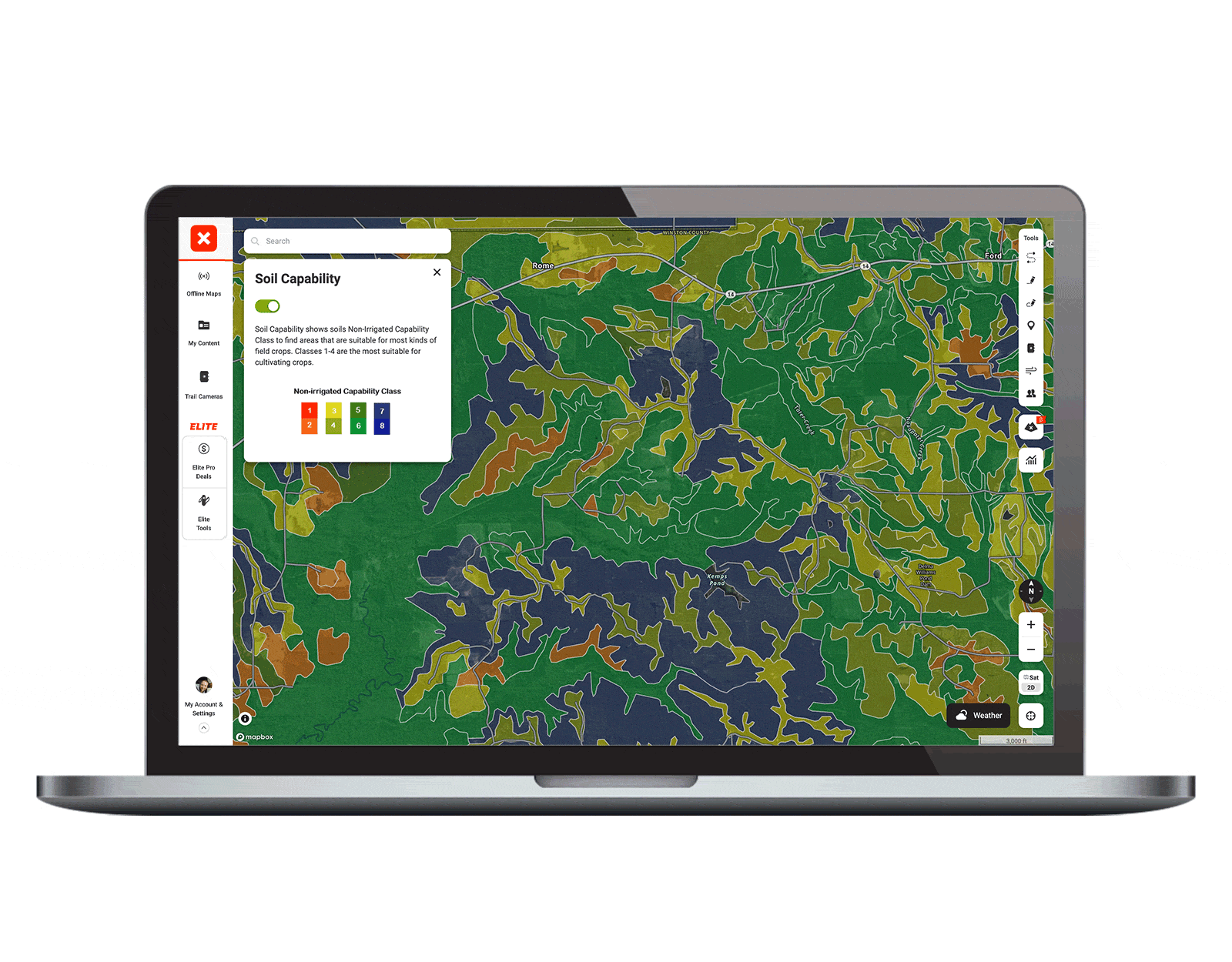
On the Web Map, hover over any color-shaded area to see the Non-Irrigated Soil Capability Class at-a-glance.
If you have the Soil Capability Map Layer turned on but are not seeing any color coding, zoom in a little and you should begin to see a patchwork of reds and greens.
We also made the Soil Capability Map Layer available for Offline Maps, so you can access the soil analysis you need anywhere.
Upgrade To See Soil Capability Insights
With onX Hunt’s Soil Capability Map Layer, understand where to place a food plot and scout areas with natural forage.
Upgrade to take advantage of Elite tools, courses, and more.
We hope you like the latest innovation offered in the Hunt App and for onX on Desktop. Reach out if you have any questions.