How To Read a Topo Map For Off-Grid Adventures
While in the backcountry, navigating elevation changes can mean the difference between safety and danger. Here are a few tips to help you decipher a map before you set foot on the trail.
Topographic maps give the backcountry enthusiast a three-dimensional view of any landscape. This map’s primary function is to indicate elevation changes which, if read correctly, can lead you to discovering peaks, valleys, saddles, slopes and all kinds of critical features for backpacking. While reading a topo map may not be as intuitive as interpreting satellite imagery, this tutorial will help connect some dots—or lines in this case. By combining fundamental topo knowledge with onX Backcountry’s unique benefits like off-grid capabilities, you’ll be well-equipped to trek farther more confidently.
How to Use Contour Lines
The crux of any topo map is its contour lines. The proximity of lines to one another indicates the elevation lost or gained on any slope aspect. Contour lines tightly packed together represent a sharp elevation change, while lines further apart represent a gradual slope. Lastly, spaces with no lines indicate flat ground.
The lines connect points on your map that are at the same elevation. Every fifth line in the sequence is a thicker line and referred to as an index line. Anywhere along that line is the exact elevation. Determining elevation change in each contour line requires taking the difference between the two index lines and dividing that by the number of intervals between the index lines. So for example, if there is 200 feet of elevation change between index lines and five intervals between those index lines, each interval line would represent 40 feet of gain or loss.
Taking this knowledge to the next level, contour lines form shapes that indicate noteworthy terrain features. Being able to identify these features and how they are typically depicted is the key to interpreting the most useful information from a topo map.
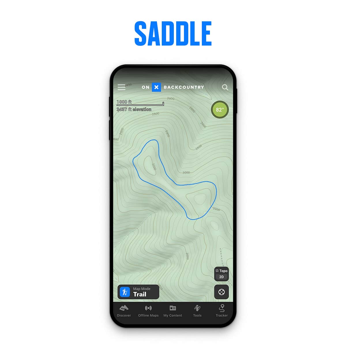
Level Up—Use Shapes To Your Advantage
Contour lines will form shapes that define terrain features. Knowing these features and how they are typically depicted by contour lines is the key to deriving the most information from a topo map.
Some Shapes to Look Out For and Why They’re Important:
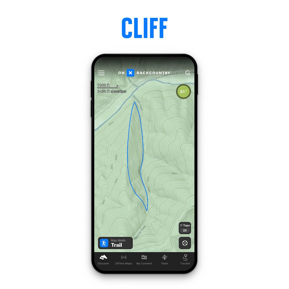
Cliffs – These are marked by extremely close contour lines, indicating a sudden drop or rise in elevation; these can be dangerous, but can also provide emergency shelter or shade.
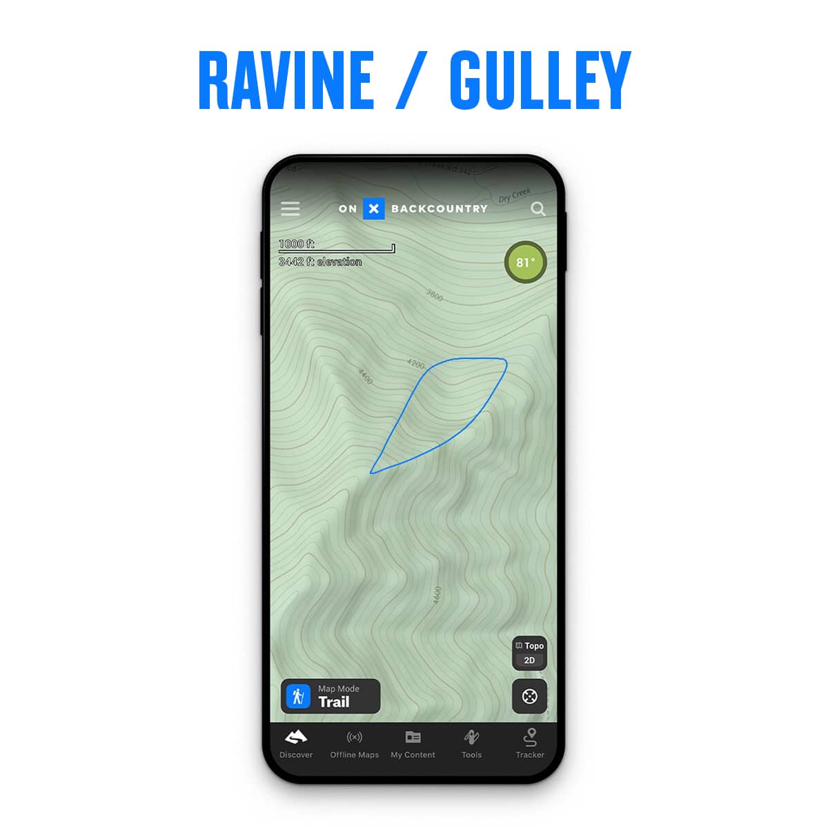
Valleys, Ravines, and Gullies – Contour lines in a U-shaped pattern will indicate rounded gullies, and V-shaped lines will denote sharper changes in altitude. Both the U and V shapes will point uphill toward higher elevations. You’re likely to find trace amounts of water by traversing through one of these features.
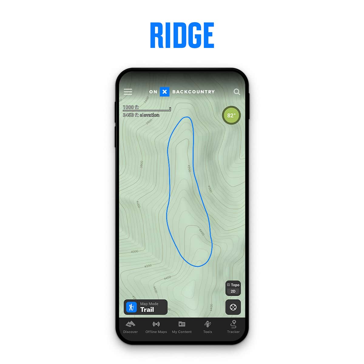
Ridges and Spurs – While on a ridge, those U and V-shaped contour lines will be further apart and slope downward indicating elevation loss. These land features provide a golden opportunity to get a lay of the land.
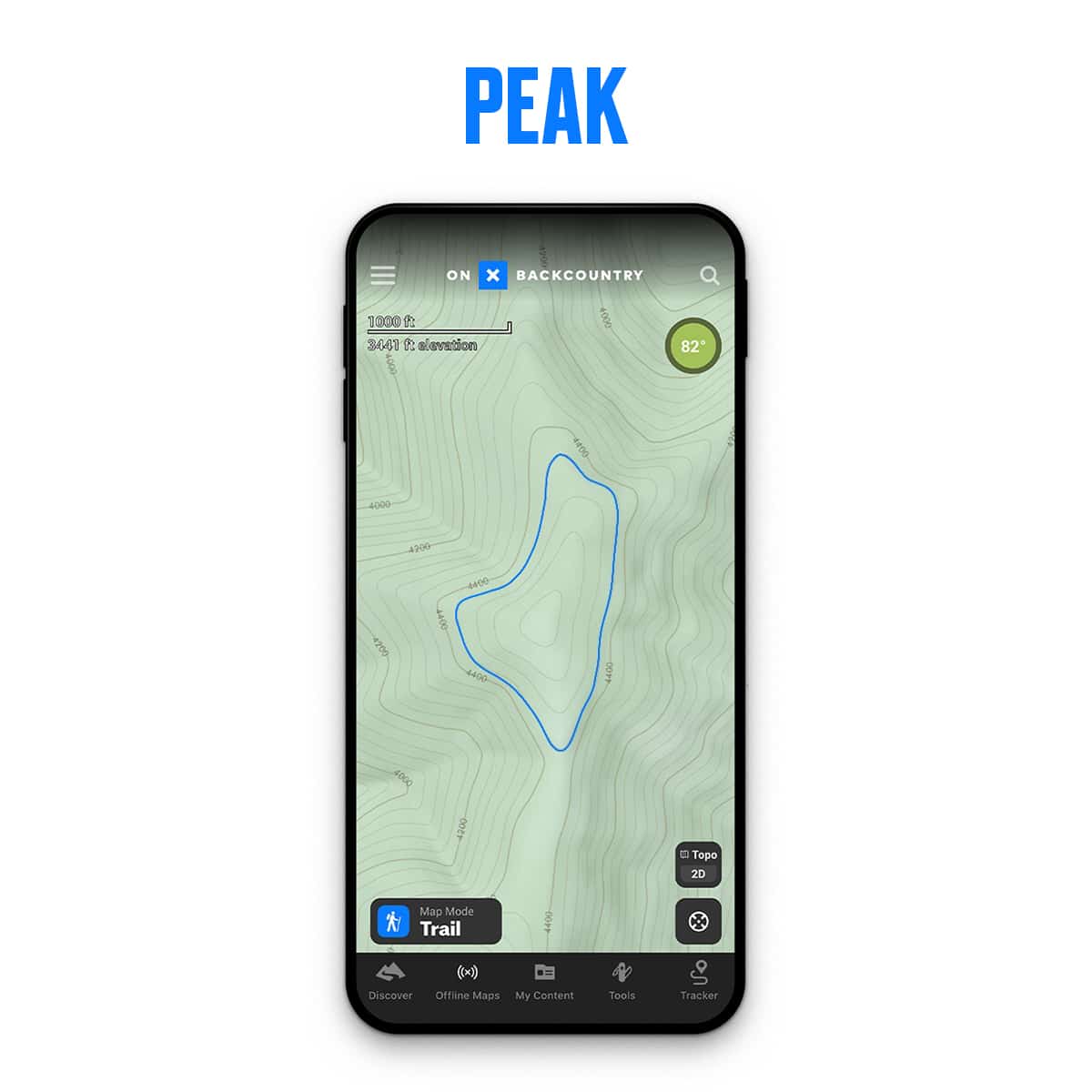
Peaks and Summits – Perhaps the easiest feature to spot, a peak will appear as a tight circle with other larger circles surrounding it. The true peak is the smallest of the circles.
Bowls – Contour lines will form a semicircle that rises from a low point.

Saddles – Contour lines will form an hourglass shape with rising contour lines on each side. Oftentimes this is the easiest way to connect two peaks while maintaining elevation.
With these tips in your back pocket, start utilizing them to create more dynamic backcountry adventures. Learn how to utilize land features to your advantage and plan a trip based on your preferences. Combine this with our Satellite and Hybrid Basemaps to have the most comprehensive understanding of the landscape before you put boots on the ground.