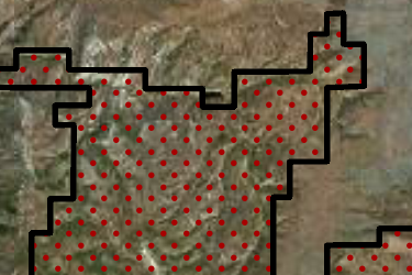
Washington Land Ownership Coverage
Our parcel coverage map lets you know at a glance which states and counties we have private land owner data for in our products. Due to differing state regulations and availability of data, we currently do not have complete coverage for every state and county. However, if a state or county makes the parcel data available, we make every effort to include it in future updates.
Note: The purpose of this map is to depict private land parcel coverage. Public land and other map layer coverage is statewide. Please note that there may be parts of some counties that do not have coverage or have unknown private landowner names.
Washington Hunting Map Layers
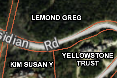
WA Private Lands
Over 2,500,000 parcels mapped by the onX team, this layer helps you know who the property owners are in Washington. Tap any parcel to learn more info about the owner and acreage.
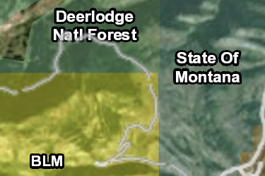
WA Gov Lands
onX has the most accurate maps of Gov Lands, covering over 21,000,000 acres in Washington. Not all Gov Lands offer access opportunities, check regulations before recreating.
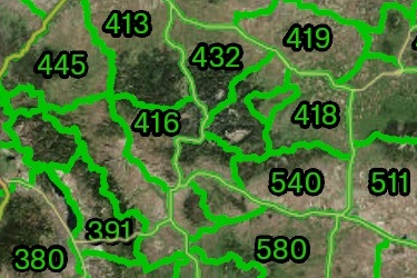
WA Hunt Units
Washington Bighorn Sheep, Deer, Elk, Moose and Mountain Goat Hunt Areas; Game Management Units. Please hunt responsibly, obey all signage and have a safe legal hunt.
Includes 8 Sublayers
- Bighorn Sheep Hunt Units
- Deer Hunt Units
- Elk Hunt Units
- Game Mgmt Units
- Moose Hunt Units
- Mtn. Goat Hunt Units
- Goose Management Areas
- Eastern and Western Hunt Regions
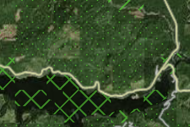
WA Possible Access
onX has mapped 4,000,000 acres of possible access lands in Washington including timber and land conservation groups. Research rules on these private lands before recreating.
WA Private Lands Hunting Opportunities
The Washington Department of Fish and Wildlife Private Lands Hunting Opportunities. Please hunt responsibly, obey all signage and have a safe legal hunt.
App Overview

Increase success as you layer BLM, forest service, private property and more over aerial imagery, and topographic basemaps, for the most accurate map on mobile device and desktop.
See invisible property lines and seek permission with detailed private and public property boundaries and ownership names.
View trails, roads and accesses to narrow the hunt and always know where you stand.
- Landowner names & boundaries
- Satellite imagery with topo lines
- Offline maps
- Sync mobile and computer
- GPS, waypoints, tracks, and markups
- Color-coded public lands
- State-specific map layers
- Roads & trails
- Hunting zones, units, districts and areas
- Search by landowner, places or coordinates
- Mark and measure areas
onX Membership Overview
Map details
- Private landowner names, boundaries, and tax address
- Public lands—federal, state, county, local and non-profit
- 2020-21 Game Management Unit boundaries
- 2020 Private Lands Hunting Opportunities (PLHO – Feel Free to Hunt, Register to Hunt, Hunt by Written Permission, or Hunt by Reservation lands), Access Points, and Safety Zones
- 2020-21 Bighorn sheep, deer, elk, moose and mountain goat hunt unit information
- Wilderness area boundaries
- Roads, trails and trailhead names and numbers
- Point of interests—geographic and recreational
- Water—rivers, creeks and lakes with flow direction
- Weather and radar
- Campgrounds
- 24K topo
- Section lines and numbers
- Fishing access locations and boat ramps
- Recreation sites
- National Park visitor maps
- Historic wildfire perimeters
- Active fires
- Possible access lands
- Much more
Compatibility
onX Hunt prides itself in offering a multi-platform mapping system. Hunt App works on iOS and Android mobile phones as well as provides access to our mapping solutions from your computer.
Map updates
As land ownership, hunting areas, and other map data change we update the map data on our servers. This new map data will automatically be loaded to your Hunt App without you having to do anything.
onX Hunt GPS Chip
Important announcement regarding the onX Hunt Chip
Effective immediately, the onX Hunt Chip for 29 of the 50 U.S. states will no longer be available for purchase. The final 21 states will still be available for purchase through Dec. 31, 2022. Click “Learn More” below to find out when the onX Hunt Chip will be discontinued for this state.
Chip Updates
Version 21.1 Released on Oct 11, 2021
- Updated Private Land Hunting Opportunity Lands *current as of 10/11/21
- Updated parcel ownership in the following county: Adams
Version 21.0 Released on: June 1, 2021
- Updated Private Land Hunting Opportunity Lands *current as of 06/01/21
- Updated Game Management Unit Boundaries to reflect 2021 Hunting Regulations *current as of 06/01/21
- Updated Bighorn Sheep, Deer, Elk, Moose, Mountain Goat Hunt Unit Information to reflect 2021 Hunting Regulations *current as of 06/01/21
Version 20.1 Released on: Nov 2, 2020
- Updated Private Land Hunting Opportunity Lands *current as of 10/26/20
Version 20.0 Released on: Aug 26, 2020
- Updated Private Land Hunting Opportunity Lands *current as of 8/25/20
- 2020-21 Game Management Unit Boundaries *current as of 8/25/20
- Updated Bighorn Sheep, Deer, Elk, Moose and Mountain Goat Hunt Unit information to 2020-21 Hunting Regulations *current as of 8/25/20
Version 19.0 Released on: May 9, 2019
- Added Washington Department of Fish & Wildlife authorized license sales locations
- Updated Private Land Hunting Opportunities *current as 5/9/2019
- Updated Game Management Unit Boundaries to 2019-20 Hunting Regulations
- Updated Bighorn Sheep, Deer, Elk, Moose and Mountain Goat Hunt Unit information to 2019-20 Hunting Regulations
Version 18.1 Released on: Nov 16, 2018
- Updated Private Lands Hunting Opportunity *current as of Nov. 12, 2018
- Added shooting ranges throughout the state
Version 18.0 Released on: Jul 24, 2018
- Updated land ownership state wide
- Updated Game Management Unit Boundaries to the 2018-19 regulations
- Update Private Lands Hunting Opportunities to the 2018-19 season
- Updated National Forest and National Park trails
- Shooting Ranges added throughout the state
Version 17.0 Released on: May 17, 2017
- Updated Private Lands Hunting Opportunities (PLHO – Feel Free to Hunt, Register to Hunt, Hunt by Written Permission, or Hunt by Reservation lands), Access Points, and Safety Zones to 2017 Season
- Updated Game Management Unit boundaries to 2017-18 Regulations
Version 16.0 Released on: Aug 25, 2016
- Updated parcel data statewide
- Added dotted parcel lines to indicate interior divisions of properties
- Updated 2016-17 Private Lands Hunting Opportunities (PLHO) Lands, Safety Zones, and Access Points
- Updated 2016-17 Private Lands Hunting Opportunities (PLHO) Parking Points
- Updated Game Management Units to 2016-17
- Updated Bighorn Sheep, Deer, Elk, Moose and Mountain Goat Hunt Units to 2016-17(only visible when selecting point on GPS)
- Updated point of interest icons for parks, marinas, campgrounds, trailheads, picnic areas, fishing accesses, and many more!
- Updated FAA data
- Added more than 19,000 miles of new and updated backroads throughout the state to our transportation data, as well as updated ferry lines. Also continued to fine-tune the depiction of our roads network, separating mainlines from spur roads and major county roads from minor ones