onX Hunt Adds Game-Changing Features for the Upcoming Season
Additions include a new suite of aerial imagery, in-vehicle capabilities, and industry first trail camera integrations.
onX Hunt is announcing eight new features that will help hunters find more success this fall, including: A new mapping experience powered by a suite of aerial imagery, hands-free navigation, and the industry’s first trail camera integration.
Fresh Perspectives: New Aerial Imagery
onX Hunt has launched never-before seen perspectives, while improving the overall clarity and recency of aerial imagery. The new features include:
- Imagery on Demand: onX Elite members can now order custom, high-resolution satellite images of their hunting grounds and stitch those images onto their map. These detailed perspectives allow hunters to see current conditions, such as habitat management improvements on their whitetail property, or make critical and time-saving decisions, like whether a go-to duck pond has melted in a neighboring state. On-demand images can be viewed in 3D mode, and customized further with markups like Waypoints, Tracks, and Lines. Each image costs $59.95, and will be delivered to the onX Hunt user’s account in less than a week, on average.
- Terrain X: onX’s first proprietary 3D mapping and analysis tool allows onX Hunt Elite users to narrow in on potential hunting and habitat areas by filtering for slope aspect, angle, and elevation. For example, elk hunters can zone in on elevation bands, and look for bedding areas on mellow north-facing slopes. Furthermore, the View Shed tool helps hunters pinpoint glassing areas, visualizing what they can see from that spot, before they set out.
- Recent Imagery and Historic Look Back: Recent medium-resolution imagery gives hunters an idea of what the terrain looks like now, and what it looked like “then.” Updated every two weeks, onX Hunt Elite members can scroll through previous weeks to get a historical sense of their hunting area’s macro trends–such as snow lines, agricultural work, timber cuts, water levels, and fire impact over time.
- Leaf-Off Imagery: Available later this month to onX Hunt Elite members, Leaf-Off Imagery provides the valuable perspective of seeing a hunting area without the interference of foliage and undergrowth. This high-resolution perspective is initially available for southern and eastern states.
- 3D for iOS: onX Hunt’s powerful and immersive 3D Mode, previously accessed via the Webmap, is now available on iOS. Following suit, the 3D Elevation Exaggeration feature will also be available on mobile devices later this summer. This feature, currently accessed via the Webmap, provides comprehensive terrain analysis in places with subtle elevation changes.
“Successful hunters need to know their terrain inside and out,” said onX Hunt General Manager, Clifford Cancelosi. “We’re investing in imagery and powerful tools that give hunters boots-on-ground knowledge they can access from anywhere, year round. This level of data and detail is only available in onX Hunt. So whether you’re scouting a new area or looking for that perfect tree stand location–all the information you need is at your fingertips.”
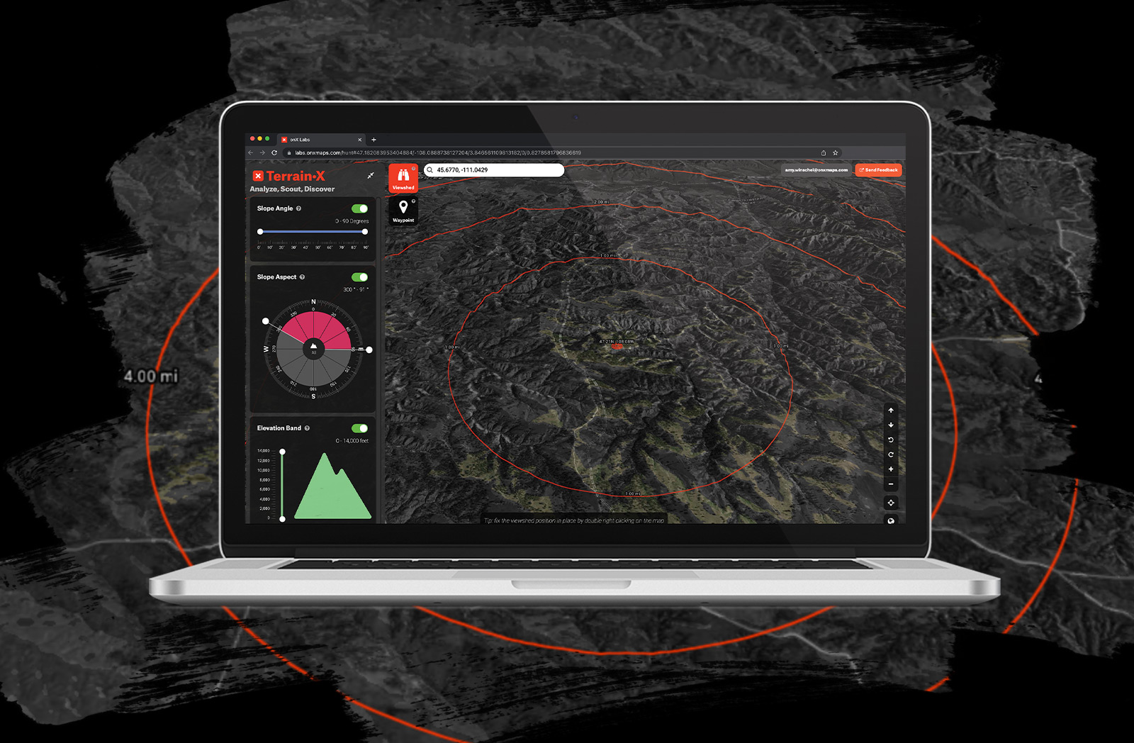
onX Hunt’s New “Terrain X” Feature
A New Way to Navigate: In-Dash Integration
- Apple CarPlay and Android Auto Integration: onX Hunt is available in the dash of Apple CarPlay- and Android Auto-enabled vehicles. Offline maps, public and private land boundaries, trails, lines, Waypoints, Tracks, and more are accessible hands-free, so hunters can scout from their trucks while keeping their eyes on the road and surrounding fields.
- Route Builder: This new navigation feature, initially available on the onX Hunt Webmap, allows hunters to quickly create a route from point A to point B with snap-to functionality. Routes can be built in a matter of seconds on any road displayed in onX, and can be followed in-dash or on mobile devices.
“Hunters spend a ton of time in their trucks, covering ground and searching for new spots,” said Cancelosi. “With onX Hunt now available in their vehicle’s dash, they can easily see private and public land information, as well as all their map content on the fly, without taking their eyes off the road.”
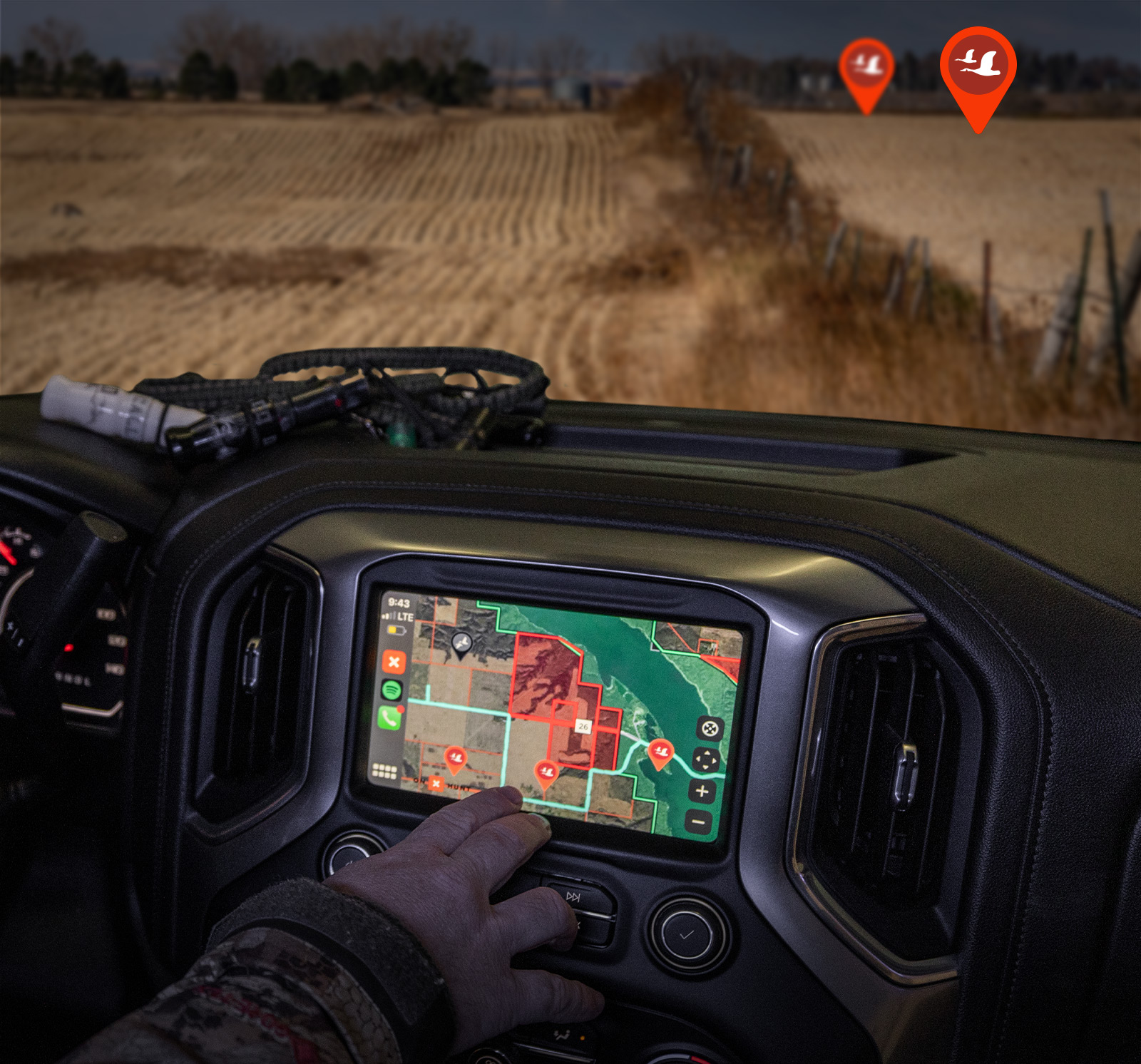
onX Hunt in your truck’s dash
A Better Way to Find Game: Trail Camera Integration
onX is revolutionizing the way hunters use and manage their trail cameras. Trail cameras are a hunter’s second favorite tool, after binoculars, according to an onX research report. Yet, hunters have historically relied on a tedious process and multiple apps to manage their imagery and make sense of their data. onX is changing that.
Today, onX Hunt members can pinpoint trail cameras on their map and directly import each camera’s imagery–storing all their intel in one app. This process is currently available via the onX Hunt Webmap and will be available via mobile app later this summer. No other hunting map application on the market allows for this seamless transfer and storage of trail camera data.
In the near future, a collaboration with industry-leading, trail camera hardware partners will take this integration to the next level. Cell cameras will automatically send imagery to the onX Hunt App, reducing digital clutter, and setting the stage for additional analysis capabilities so hunters can build a comprehensive look at the game on their property. More details on this integration will be available in August.
“Trail cameras are an integral part of hunting today,” said Cancelosi. “Yet trying to manage and organize imagery from different cameras is cumbersome. To solve that problem, onX Hunt is committed to building a holistic solution that allows users to not only organize incoming content, but also analyze and recognize imagery for the specific game they are interested in–down to ‘that buck.’ App users can combine that information with relevant weather, rut, and other data to determine when and where to go harvest that animal.”
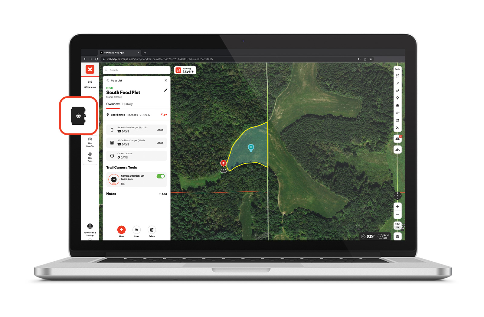
Marking and organizing trail cameras in onX Hunt
For more information about onX Hunt’s suite of new aerial imagery, visit https://www.onxmaps.com/hunt/app/features/aerial-imagery
For more details on how onX Hunt now integrates with in-dash screens, visit https://www.onxmaps.com/hunt/app/features/carplay-android-auto-in-dash
And to learn more about onX Hunt’s trail camera integration, visit https://www.onxmaps.com/hunt/app/features/cellular-trail-camera-hub
About onX
Founded in 2009, onX is a pioneer in digital outdoor navigation, developing software that helps inform, inspire, and empower outdoor recreationists. onX Hunt, onX Offroad, and onX Backcountry make up the company’s suite of apps which are built by explorers for explorers. Because off-the-beaten path experiences are at the heart of what onX does, the company also leads initiatives to protect and expand access to public land and promote stewardship opportunities. Learn more at www.onxmaps.com/about.