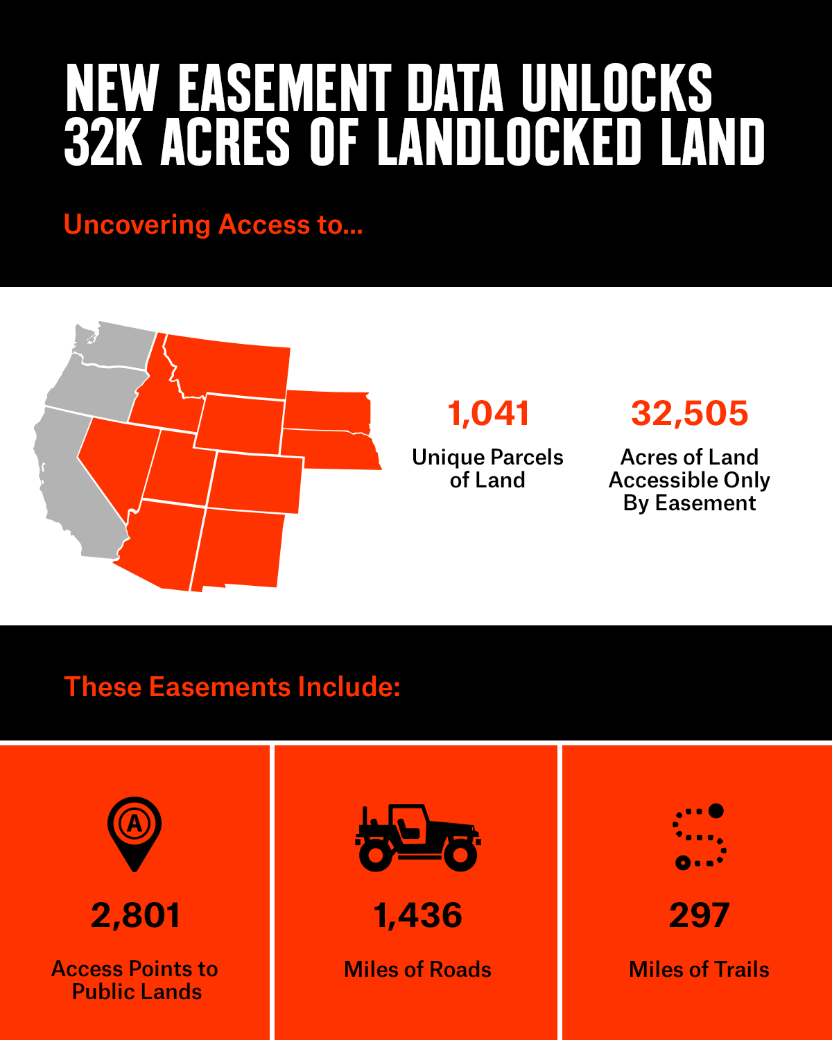
New Easement Data Unlocks 32,000+ Acres of Western Land
onX has recently added 2,801 access routes to 32,505 acres of public land in Arizona, Colorado, Idaho, Montana, Nebraska, Nevada, New Mexico, South Dakota, Utah, and Wyoming to its app thanks to map digitization efforts by the Bureau of Land Management (BLM) and United States Forest Service (USFS).
These public land acres were previously thought to be landlocked, or inaccessible without permission from neighboring landowners. By digitizing easement information sometimes stored away for decades in filing cabinets and dating as far back as the late 1800s, the BLM and USFS are making thousands of access points to public land more visible. onX has worked with the BLM and USFS in order to provide a single, convenient location for the public to find this information via its mapping and navigation app.
In 2019, the BLM began a pilot project in its Montana/Dakotas District to digitize road and trail access easements. The USFS also began digitizing its easements, including rights-of-way in each of their regions, and in 2020 a group of onX geospatial analysts met with local USFS personnel to better understand this complex process. Then in early 2022, the Modernizing Access to Our Public Land Act (MAPLand Act) was signed into law.
The MAPLand Act requires federal easement records, along with other land and water access data, to be made available to the public in digital format within five years. The passage of the MAPLand Act was influenced by a series of reports on the country’s landlocked public lands, published by onX and the Theodore Roosevelt Conservation Partnership (TRCP). By sharing its land ownership data expertise, onX illuminated how millions of acres in the west are inaccessible or are perceived to be inaccessible because complete information on paper files in district offices are not readily available in a digital format. In 2021, onX was awarded a BLM State Director’s Stewardship Award for its efforts.
“The BLM is very excited to see public lands access data for Montana incorporated into the onX Hunt App,” said Adam Carr, BLM Montana/Dakotas District Public Access Project Manager. “onX continues to be a strong BLM partner and advocate for public land access, and adding this data puts new information at the fingertips of an increasing number of hunters and recreationists. We’re looking forward to providing the same information to even more Western states in the coming years.”
By integrating this recently-digitized BLM and USFS data into its Apps, onX will help hunters and recreators find new access opportunities to remote public lands. To date, onX has incorporated USFS data for Arizona, Colorado, Idaho, Montana, Nebraska, Nevada, New Mexico, South Dakota, Utah, and Wyoming, in addition to BLM data from the Montana/Dakotas District. As additional data is sourced and curated from across all 50 states, onX will continue to add that information to its Apps, improving land access visibility for outdoor recreationists for years to come.
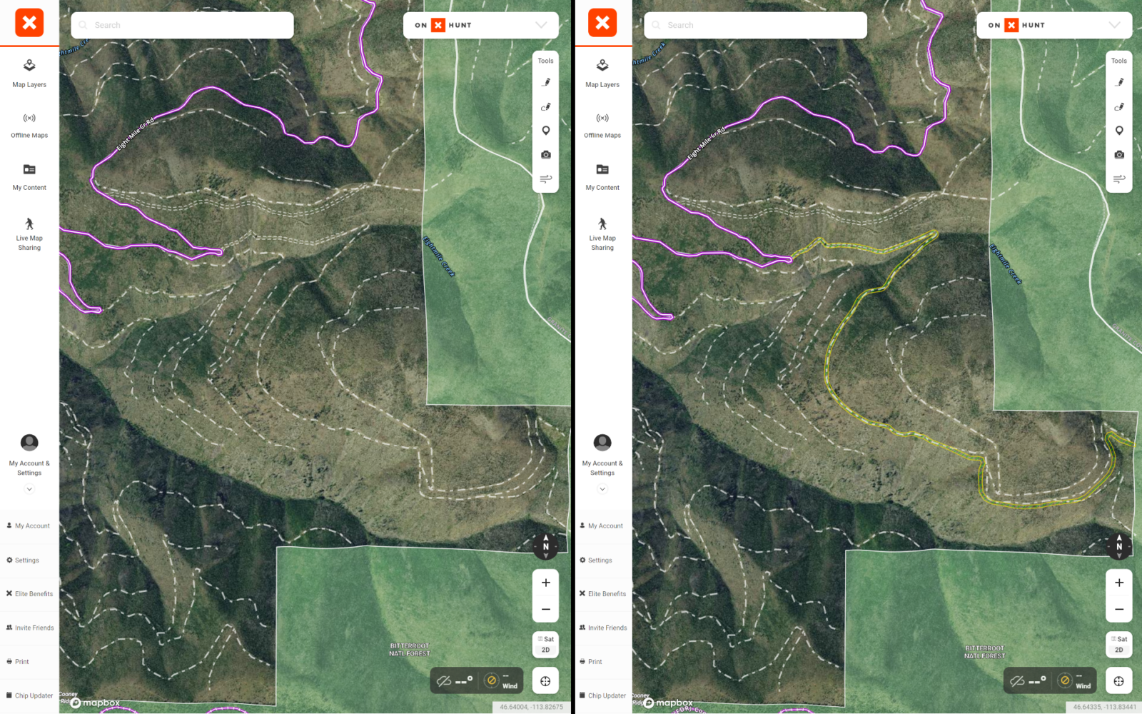
Currently, onX Hunt members can view these and future easements in the app’s Government Lands layer.
Learn more about how onX is leading the industry in land access initiatives.