
Dirt Bike Trails
Near Provo, Utah
Explore All Dirt Bike Trails Near Provo, Utah
Dirt Bike Trails Near Provo, Utah
Discover the best dirt bike trails near you. Browse trail maps, check difficulty ratings, and find your next adventure — whether you're looking for a quick ride or an all-day expedition.
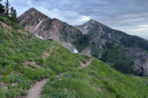
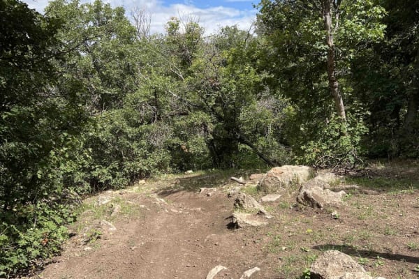
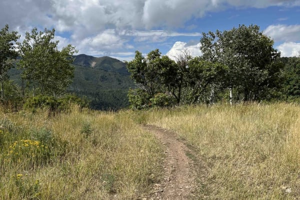
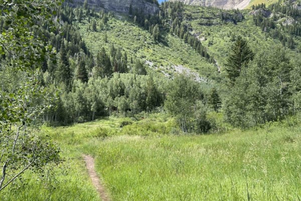
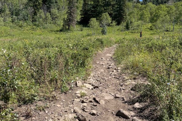
Rock Canyon - Dry Fork
This challenging singletrack starts immediately from Forest Road 70027, quickly narrowing with dense brush. As you climb through aspen groves, expect occasional sharp drops toward the creek. Higher up, you'll find flat open spaces before the final ascent. The steep northern slope of Freedom Peak, cr...
Learn more about Rock Canyon - Dry Fork
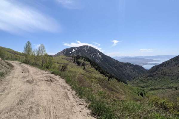
Kyhv Peak
From Provo Canyon the road to Hope Campground is paved. From Hope Campground to Rock Canyon campground the road is easy and relatively smooth dirt. Beyond Rock Canyon Campground the road becomes progressively more rocky and rutted until the final couple of miles where the road becomes easier. Th...
Learn more about Kyhv Peak
West Crest
The West Crest trail runs along the spine of West Mountain in southern Utah County. Hypothetically it can be done fully from the north to south (or vice versa) without having to do an out and back. Having tried this from various directions, logistically it is difficult to do due to a very steep sect...
Learn more about West Crest
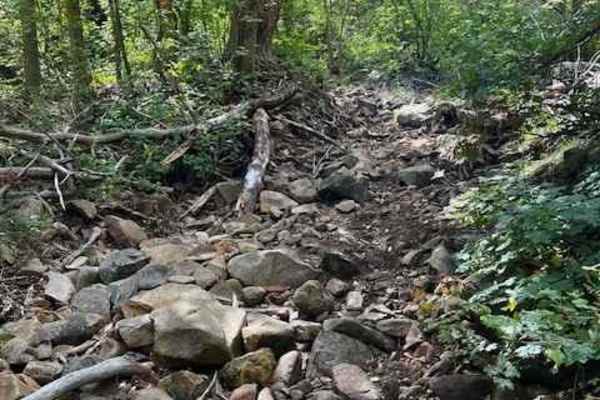
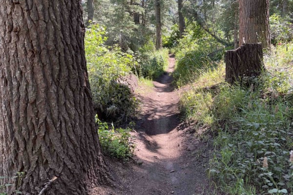
Right Fork Days Canyon (8004)
Right Fork Days Canyon splits off from Left Fork Days Canyon trail. This single-track trail dead ends after about a mile of riding. The entrance is easy to miss and doesn't have any signage. This route starts with a winding hill climb and then follows a stream. It is very difficult once in the strea...
Learn more about Right Fork Days Canyon (8004)
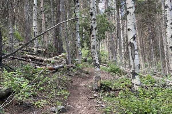
Kirkman Hollow (8012)
Kirkman Hollow begins at a parking lot off Hobble Fork Canyon Road and gains nearly 2,000 feet of elevation before intersecting with the Mapleton-Sawmill Hollow Trail. The single-track trail follows a ravine which is mostly smooth. There are some embedded boulders in a few areas, but they are easy t...
Learn more about Kirkman Hollow (8012)
Left Fork Hobble Creek - FS 70132
Left Fork Hobble Creek (FS 70132) may share the same name as Forest Service Road 70147, but the two roads are quite different. Starting at the intersection where FS 70147, Wing Flat (FS 70619), and this meet up, Left Fork Hobble Creek (FR 70132) descends southwest to a narrow canyon surrounded by ta...
Learn more about Left Fork Hobble Creek - FS 70132
Left Fork Days Canyon (8011)
Left Fork Days Canyon is one of the entrances into the Hobble Creek trail system. It's a 3.6-mile trail that starts off Hobble Fork Canyon Road with a stream crossing. The stream here is surprisingly deep and the trail on the opposite side has almost been taken out by water and wheelspin erosion. Co...
Learn more about Left Fork Days Canyon (8011)
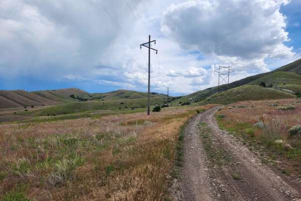
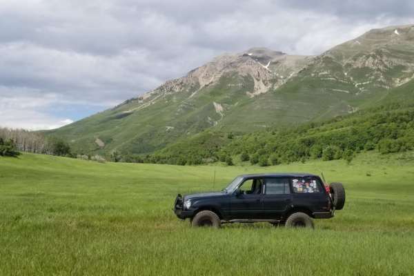
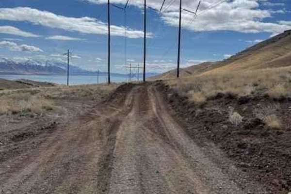
Powerline Road
This trail is a fun, easy cruise that follows the powerlines south-west of Saratoga Springs UT up and over some of the Lake Mountain foothills. The trail has some great views of the Utah lake and takes you into some neat areas that are worth exploring further on your own! This is a great trail for a...
Learn more about Powerline Road
Left Fork Maple Canyon (8006)
Left Fork Maple Canyon branches from the Mapleton-Sawmill Hollow trail and travels west to the parking lot at Maple Diamond Fork. Riding this direction, the single-track trail is wide and primarily downhill. There's loose gravel and small rocks on the east side of the trail, which then turns into a ...
Learn more about Left Fork Maple Canyon (8006)
Little Diamond (8016)
Little Diamond Trail runs along a ridge south from the Mapleton-Sawmill Hollow Trail and eventually intersects with Diamond Fork Road. Heading towards the road, you'll drop ~2,300 feet in elevation. The beginning of the trail has a steep, washed-out section that would be difficult to ride up (north)...
Learn more about Little Diamond (8016)
Mapleton-Sawmill Hollow (8013)
Mapleton-Sawmill Hollow runs along a ridgeline between Kirkman Hollow and Left Fork Maple Canyon trails. The trail is a mixture of flowy and loose-rock sections with multiple smaller hills thrown in. The rock sections range from gravel to baseball-sized and are usually loose. Riding southwest, about...
Learn more about Mapleton-Sawmill Hollow (8013)
Upper Packard Canyon Trail
Ascending through the captivating Hobble Creek Canyon, the Upper Packard Canyon Trail is a formidable challenge for dirt bike enthusiasts seeking an exhilarating adventure. This single-track trail, boasting a level of difficulty that appeals to experienced riders, presents an electrifying journey ch...
Learn more about Upper Packard Canyon Trail
Timpooneke to Chris' Flat (2151)
This single-track trail connects the Timpanooke parking lot to Timpooneke Forest Road. From the parking lot riding west, the trail climbs to the next intersection with Bear Canyon Spur and features several big rock sections. These rocks are basketball-sized or larger, embedded in the ground, and cre...
Learn more about Timpooneke to Chris' Flat (2151)
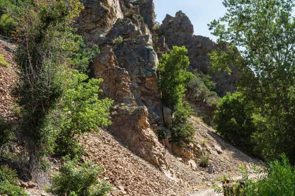
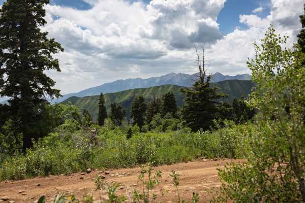
Timpooneke Road
This is a high-altitude Uinta-Wasatch-Cache National Forest road starting at the back of the Timpooneke Campground and wrapping around the face of the Timpanogos Wilderness Area. It is approximately 19 miles round trip and a there-and-back road. The route is rocky, but the rough road pays off with a...
Learn more about Timpooneke Road
South Fork Little Deer Creek (2252)
This track connects Ridge Trail to Lame Horse near the Alpine Loop Summit Parking Lot. Starting from Ridge, this wooded trail has great flow when traveling downhill. There are a few root sections mixed in, but you don't notice them traveling downhill away from Ridge trail. There are 2 road crossings...
Learn more about South Fork Little Deer Creek (2252)
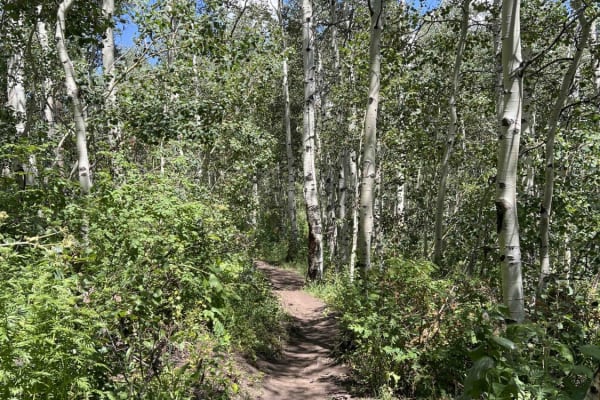
Lame Horse (2055)
Lame Horse runs from the Alpine Loop Summit parking lot to the base of Mount Timpanogos hiking trails. It's a dead end with views of the mountain, but nowhere to go but back towards the parking lot. The single-track trail cuts through an aspen forest and is generally flat without any major obstacles...
Learn more about Lame Horse (2055)
Willow Hollow (2159)
Willow Hollow begins at the Alpine Loop Summit parking lot and descends to Salamander Flat Trail. This single-track trail is extremely tight and twisty near the parking lot. There are some roots and cut trees to watch out for at foot peg-level. There isn't much flow to this top section-it feels more...
Learn more about Willow Hollow (2159)
Bear Canyon Spur (2178)
Bear Canyon Spur is a short trail that runs between Timpooneke-Chris' Flat and Bear Canyon trails. The trail is narrow and drops downhill as you ride towards Bear Canyon. There are a few smaller, golf ball- or baseball-sized rock sections and several tight turns. There's also one road crossing at Ti...
Learn more about Bear Canyon Spur (2178)
Dutchmen Run
This trail is an easy cruise at a slow pace with absolutely stunning views of the lake and mountains. At speed, this trail becomes one of the most thrilling trails in this area that will test your suspension and your talent. The trail is pretty straight and runs along the power lines and has recentl...
Learn more about Dutchmen Run
Wing Flat - FR 70619
Deep ruts, large bumps, and amazing views can be expected from Wing Flat (FR 70619). A large portion of this road (about three miles) tightly hugs the side of a mountain. This shelf road is quite high, but offers grandiose views of Corral Mountain to the south at 10,423', East Provo Peak at 11,043...
Learn more about Wing Flat - FR 70619
ATV trails near Provo, Utah
Explore ATV-friendly trails near you. These trails are accessible for vehicles up to 50 inches wide, perfect for ATVs and smaller off-road machines.
West Crest
The West Crest trail runs along the spine of West Mountain in southern Utah County. Hypothetically it can be done fully from the north to south (or vice versa) without having to do an out and back. Having tried this from various directions, logistically it is difficult to do due to a very steep sect...
Learn more about West Crest
Left Fork Hobble Creek - FS 70132
Left Fork Hobble Creek (FS 70132) may share the same name as Forest Service Road 70147, but the two roads are quite different. Starting at the intersection where FS 70147, Wing Flat (FS 70619), and this meet up, Left Fork Hobble Creek (FR 70132) descends southwest to a narrow canyon surrounded by ta...
Learn more about Left Fork Hobble Creek - FS 70132
Powerline Road
This trail is a fun, easy cruise that follows the powerlines south-west of Saratoga Springs UT up and over some of the Lake Mountain foothills. The trail has some great views of the Utah lake and takes you into some neat areas that are worth exploring further on your own! This is a great trail for a...
Learn more about Powerline Road
Timpooneke Road
This is a high-altitude Uinta-Wasatch-Cache National Forest road starting at the back of the Timpooneke Campground and wrapping around the face of the Timpanogos Wilderness Area. It is approximately 19 miles round trip and a there-and-back road. The route is rocky, but the rough road pays off with a...
Learn more about Timpooneke Road
UTV/side-by-side trails near Provo, Utah
Find UTV and side-by-side trails near you. These trails accommodate vehicles up to 60 inches wide, ideal for UTVs, side-by-sides, and wider off-road rigs.
Kyhv Peak
From Provo Canyon the road to Hope Campground is paved. From Hope Campground to Rock Canyon campground the road is easy and relatively smooth dirt. Beyond Rock Canyon Campground the road becomes progressively more rocky and rutted until the final couple of miles where the road becomes easier. Th...
Learn more about Kyhv Peak
West Crest
The West Crest trail runs along the spine of West Mountain in southern Utah County. Hypothetically it can be done fully from the north to south (or vice versa) without having to do an out and back. Having tried this from various directions, logistically it is difficult to do due to a very steep sect...
Learn more about West Crest
Left Fork Hobble Creek - FS 70132
Left Fork Hobble Creek (FS 70132) may share the same name as Forest Service Road 70147, but the two roads are quite different. Starting at the intersection where FS 70147, Wing Flat (FS 70619), and this meet up, Left Fork Hobble Creek (FR 70132) descends southwest to a narrow canyon surrounded by ta...
Learn more about Left Fork Hobble Creek - FS 70132
Powerline Road
This trail is a fun, easy cruise that follows the powerlines south-west of Saratoga Springs UT up and over some of the Lake Mountain foothills. The trail has some great views of the Utah lake and takes you into some neat areas that are worth exploring further on your own! This is a great trail for a...
Learn more about Powerline Road
The onX Offroad Difference
onX Offroad combines trail photos, descriptions, difficulty ratings, width restrictions, seasonality, and more in a user-friendly interface. Available on all devices, with offline access and full compatibility with CarPlay and Android Auto. Discover what you're missing today!
Open Trail Map