
Beginner Off-Road Trails
Near Cal-Nev-Ari, Nevada
Explore All Beginner Trails Near Cal-Nev-Ari, Nevada
Beginner Off-Road Trails Near Cal-Nev-Ari, Nevada
Discover the best beginner-friendly off-road trails near you. These easier, lower-rated trails are a great place to start — browse trail maps, check difficulty ratings, and find your next adventure.
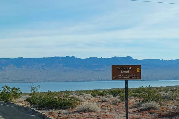
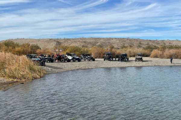
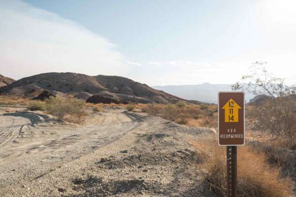
Tamarisk Road
Tamarisk Road runs through Lake Mead National Recreation Area. This area is a limited-use area, and camping is only allowed in approved areas, offroad use is not allowed unless on a designated route. It is an easy road but can be loose sand in sections, 4x4 is recommended, in the rainy season this a...
Learn more about Tamarisk Road
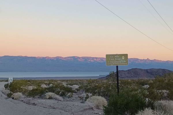
Six Mile Cove Road
Six Mile Cove Road is an easy road but can be loose sand in sections, 4x4 is recommended, in the rainy season this area is prone to flash floods. It runs through Lake Mead National Recreation Area. This area is a limited-use area, and camping is only allowed in approved areas, offroad use is not all...
Learn more about Six Mile Cove Road
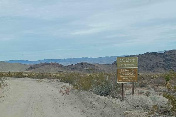
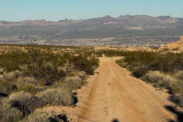
Rockefeller Mine Road
Rockefeller Mine road is mixed surface gravel, sand, and loose rock road that runs through both Lake Mead National Recreation Area and Bureau of Land Management Government Lands. This road offers stunning views of the remote Nevada landscape, between the river in the distance to tall towering mounta...
Learn more about Rockefeller Mine Road
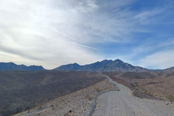
Christmas Tree Pass
Christmas Tree Pass is a fun, dirt road adventure in the hills above the Colorado River on the Arizona/Nevada border. It is named for a tree on the trail that is decorated with christmas ornaments. This is a relatively easy drive, with the occasional need for 4Lo on the east section when the sand is...
Learn more about Christmas Tree Pass
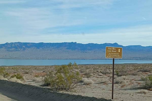
Nine Mile Cove Road
Nine Mile Cove Road runs through Lake Mead National Recreation Area. This area is a limited-use area, and camping is only allowed in approved areas. Offroad use is not allowed unless on a designated route. It is an easy road but can be loose sand in sections. 4x4 is recommended. In the rainy season,...
Learn more about Nine Mile Cove Road
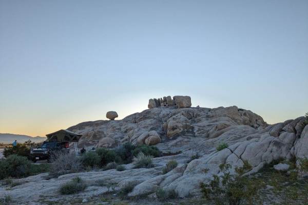
95 to Balancing Rock Camp
This is a slow but easy trail heading east from 95 to Balancing Rock Camp. Existing ruts and additional rain can make this trail more difficult. From 95, turn east at Old Cable Trail. Follow the trail for approximately 3 miles, where you come across a large boulder hill to the south. Several gorgeou...
Learn more about 95 to Balancing Rock Camp
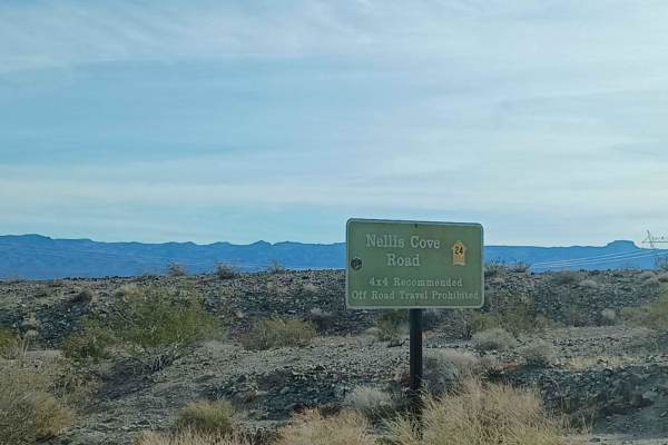
Nellis Cove Road
Nellis Cove Road runs through Lake Mead National Recreation Area. This area is a limited-use area, and camping is only allowed in approved areas, offroad use is not allowed unless on a designated route. It is an easy road but can be loose sand in sections, 4x4 is recommended, in the rainy season thi...
Learn more about Nellis Cove Road
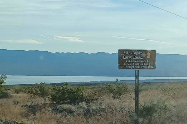
Mid Basin Cove
Mid-Basin Cove road is an easy road but can be loose sand in sections, 4x4 is recommended, in the rainy season this area is prone to flash floods. It runs through Lake Mead National Recreation Area. This area is a limited-use area, and camping is only allowed in approved areas, offroad use is not al...
Learn more about Mid Basin Cove
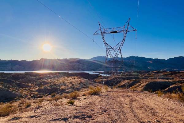
Mead Davis Powerline Road
The first half of the trail is hard pack dirt with rutted areas and uneven grades, single-car wide. The second half of the trail is washes with two-car wide areas most of the way and single-car wide as you get closer to the lake. Large boulders are in the wash so if you are in the dust drive careful...
Learn more about Mead Davis Powerline Road
Balancing Boulder Camp to Needles Highway
This trail takes you from Balancing Boulder Camp down to the Needles Highway, where you can head south to Needles or north to Laughlin/Bullhead City. Starting at camp around 2,500 feet of elevation, you drop to just 700 feet in a little more than 7 miles. Once you cross into Nevada, marked by the Am...
Learn more about Balancing Boulder Camp to Needles Highway
Mead Davis Power Road
Mead Davis Power Road is a rocky, dusty, sandy, rutted, washed-out road. Some sections require a short wheelbase high clearance vehicle, otherwise, its an easy road 4x4 is highly recommended. There is a chance for water crossings when in the rainy seasons and flash floods. The road runs through both...
Learn more about Mead Davis Power Road
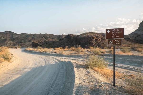
Nevada Telephone Cove Road
The Nevada Telephone Cove Road is inside the Lake Mead National Recreation Area boundary and starts just off State Route 163 a few miles outside of Laughlin, Nevada. This is a well-trafficked and reasonably maintained double-wide dirt road winding through the Mohave desert hillside leading to Teleph...
Learn more about Nevada Telephone Cove Road
Stonehouse Trail
The Stonehouse Trail is a single-wide dirt road that winds through desert hills in the Lake Mead National Recreation Area and passes by an old stone house ruin. The road is not technical but has some pretty sandy sections and a couple of rutted areas that require a 4WD with high clearance. The road ...
Learn more about Stonehouse Trail
Princess 4x4 Telephone Line Trail
This trail starts from the lower wash on the Princess Cove Trail. It heads up a narrow, loose, rocky hill. The trail surface is rocky and bumpy for a while, running along the top of the ridge before dropping down a steep hill into a sandy wash. There are some rockier ledges to navigate in the middle...
Learn more about Princess 4x4 Telephone Line Trail
Airport Cove Loop
This short out-and-back trail picks up off the end of Willow Cove Trail. This trail leads to several dispersed campsites and access to Lake Mojave. This trail is a one-lane road specified by a sign on the way in. It is rated a two because the trail is only one car wide. Oncoming vehicles would have ...
Learn more about Airport Cove Loop
A Mine Runs Through It
This trail winds through an area rich in mining history, offering a glimpse into the region's past while providing an enjoyable off-road experience. The route is mostly easygoing, with a few short but rocky climbs to keep things interesting. While the trail itself is open for travel, a private easem...
Learn more about A Mine Runs Through It
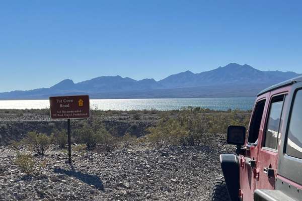
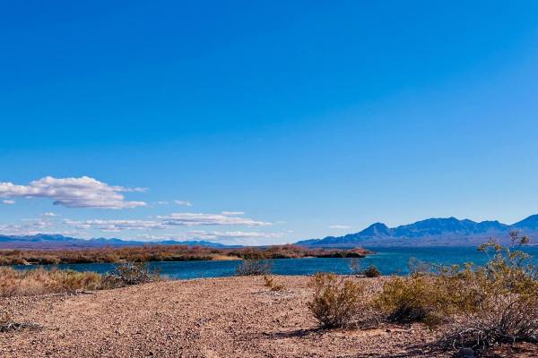
Pot Cove Road
This short side trail off the East Cottonwood Cove Road leads to the more popular beach area which has toilet facilities. A good side trip while in the area to view Lake Mohave and relax. Great for camping, kayaking, fishing, or sitting around a bonfire (when conditions permit) in the evening.
Learn more about Pot Cove Road
Carp Cove to Cottonwood Cove
This trail connects the Cottonwood Cove on Lake Mojave to Carp Cove. Signs are posted indicating a 17-day camping limit. Off-road driving is only allowed on trails marked with a yellow arrow in this area. Keep your eye out for those. Driving off-road on all other trails is prohibited. 4x4 is recomme...
Learn more about Carp Cove to Cottonwood Cove

Princess Wash Cove
This trail is on the southern end of Lake Mojave. This end of the Lake Mead National Recreation Area has an entrance station and lake use fees. Lake Mead passes can be purchased online or at one of the entrance stations. Entrance fees are $25 per vehicle;admit a private non-commercial vehicle for 1-...
Learn more about Princess Wash Cove
Willow Tree Cove
This trail is an out-and-back finger off of a main trail. There is a small sand gravel wash to cross at the beginning of the trail. The rest of the trail beyond is twisty and quite easy. Areas of the trail have fencing to keep vehicles from exploring off-road. The trail ends at a small campsite righ...
Learn more about Willow Tree Cove
Beginner ATV trails near Cal-Nev-Ari, Nevada
Explore ATV-friendly trails near you. These trails are accessible for vehicles up to 50 inches wide, perfect for ATVs and smaller off-road machines.
Tamarisk Road
Tamarisk Road runs through Lake Mead National Recreation Area. This area is a limited-use area, and camping is only allowed in approved areas, offroad use is not allowed unless on a designated route. It is an easy road but can be loose sand in sections, 4x4 is recommended, in the rainy season this a...
Learn more about Tamarisk Road
Six Mile Cove Road
Six Mile Cove Road is an easy road but can be loose sand in sections, 4x4 is recommended, in the rainy season this area is prone to flash floods. It runs through Lake Mead National Recreation Area. This area is a limited-use area, and camping is only allowed in approved areas, offroad use is not all...
Learn more about Six Mile Cove Road
Rockefeller Mine Road
Rockefeller Mine road is mixed surface gravel, sand, and loose rock road that runs through both Lake Mead National Recreation Area and Bureau of Land Management Government Lands. This road offers stunning views of the remote Nevada landscape, between the river in the distance to tall towering mounta...
Learn more about Rockefeller Mine Road
Nine Mile Cove Road
Nine Mile Cove Road runs through Lake Mead National Recreation Area. This area is a limited-use area, and camping is only allowed in approved areas. Offroad use is not allowed unless on a designated route. It is an easy road but can be loose sand in sections. 4x4 is recommended. In the rainy season,...
Learn more about Nine Mile Cove Road
Beginner UTV/side-by-side trails near Cal-Nev-Ari, Nevada
Find UTV and side-by-side trails near you. These trails accommodate vehicles up to 60 inches wide, ideal for UTVs, side-by-sides, and wider off-road rigs.
Tamarisk Road
Tamarisk Road runs through Lake Mead National Recreation Area. This area is a limited-use area, and camping is only allowed in approved areas, offroad use is not allowed unless on a designated route. It is an easy road but can be loose sand in sections, 4x4 is recommended, in the rainy season this a...
Learn more about Tamarisk Road
Six Mile Cove Road
Six Mile Cove Road is an easy road but can be loose sand in sections, 4x4 is recommended, in the rainy season this area is prone to flash floods. It runs through Lake Mead National Recreation Area. This area is a limited-use area, and camping is only allowed in approved areas, offroad use is not all...
Learn more about Six Mile Cove Road
Rockefeller Mine Road
Rockefeller Mine road is mixed surface gravel, sand, and loose rock road that runs through both Lake Mead National Recreation Area and Bureau of Land Management Government Lands. This road offers stunning views of the remote Nevada landscape, between the river in the distance to tall towering mounta...
Learn more about Rockefeller Mine Road
Nine Mile Cove Road
Nine Mile Cove Road runs through Lake Mead National Recreation Area. This area is a limited-use area, and camping is only allowed in approved areas. Offroad use is not allowed unless on a designated route. It is an easy road but can be loose sand in sections. 4x4 is recommended. In the rainy season,...
Learn more about Nine Mile Cove Road
The onX Offroad Difference
onX Offroad combines trail photos, descriptions, difficulty ratings, width restrictions, seasonality, and more in a user-friendly interface. Available on all devices, with offline access and full compatibility with CarPlay and Android Auto. Discover what you're missing today!
Open Trail Map