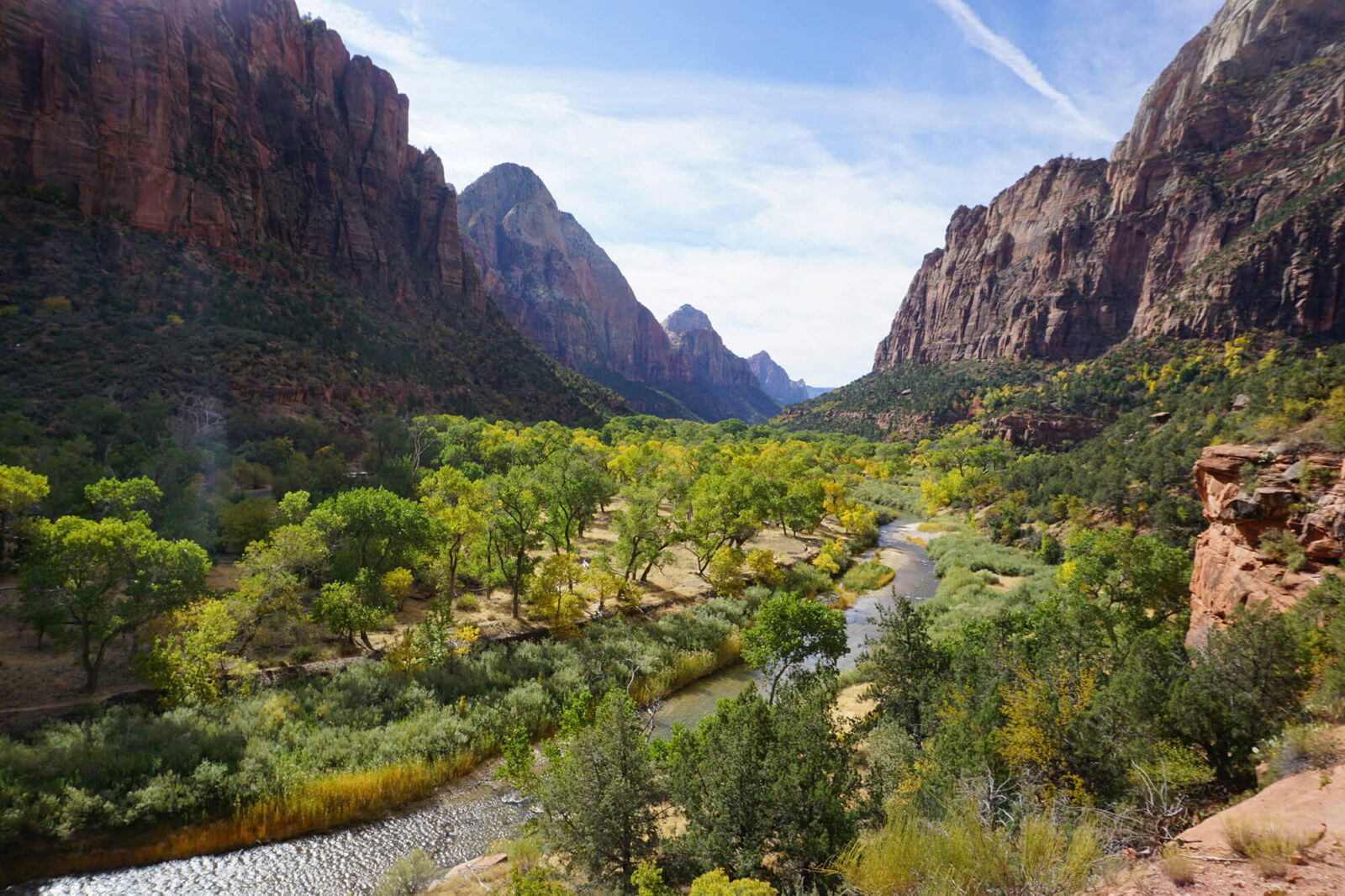
BLM Land Near Zion National Park
BLM land abounds in Southern Utah and with the interactive map below you can discover camping spots, off-roading opportunities, and more on BLM land not far from Zion.
BLM land abounds in Southern Utah and with the interactive map below you can discover camping spots, off-roading opportunities, and more on BLM land not far from Zion.
BLM Land Near Zion National Park
BLM public lands nearly surround Zion National Park on all sides and with them come many opportunities for dispersed camping, hiking, and OHV riding. The BLM manages public lands that offer all kinds of recreational opportunities, including free, dispersed camping.
Camping Near Zion
When camping near Zion National Park, you have three choices:
1. Reserving a Campsite
There are several campsites located inside the park itself and just outside the park. The campsites within the park are much harder to reserve, especially on short notice. We recommend you explore Zion National Park’s reservable campgrounds on the Recreation.gov website.
- Lava Point Campground
- South Campground
- Watchman Campground
2. Dispersed camping in nearby National Forest
Dispersed camping, also known as boondocking and dry camping, may only be available at designated sites, not just any flat spot you find. Each national forest website (such as Dixie National Forest) lists areas with pre-established dispersed sites.
3. Dispersed camping in BLM Land
Camping is allowed on lots of BLM land, whether in established campgrounds or through dispersed camping. BLM-managed campgrounds often include restrooms, potable water, electrical hookups, picnic areas, garbage cans, tent pads, and group shelters. These campgrounds nearly always require nightly fees and/or advance permits.
If you are looking for established BLM campgrounds, BLM.gov hosts an interactive map showing all its campgrounds. We also have our interactive map below.
Dispersed camping is free and available for most BLM-managed public lands as it does not conflict with other authorized uses or in areas posted “closed to camping.” Dispersed camping is limited to 14 days within a 28 consecutive-day period. Camping limitations can vary greatly by local office, so always check in advance with a field office. Dispersed camping areas are located along most secondary roads and may not be marked. The most popular locations are evident as flat disturbed areas that have been used as a campsites before, but not all flat sites are campsites. It’s a best practice to use a previously established camping area instead of creating a new disturbance.
View BLM Land Maps in the field with the following onX Products:
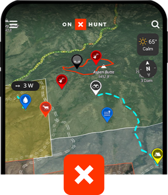
onX Hunt
Trusted by millions of hunters
-
 852 Million Acres of Public Land
 - Color-Coded Public and Private Land Boundaries
- Pro Deals on Top Hunting Brands
- Trail-Cam Integration
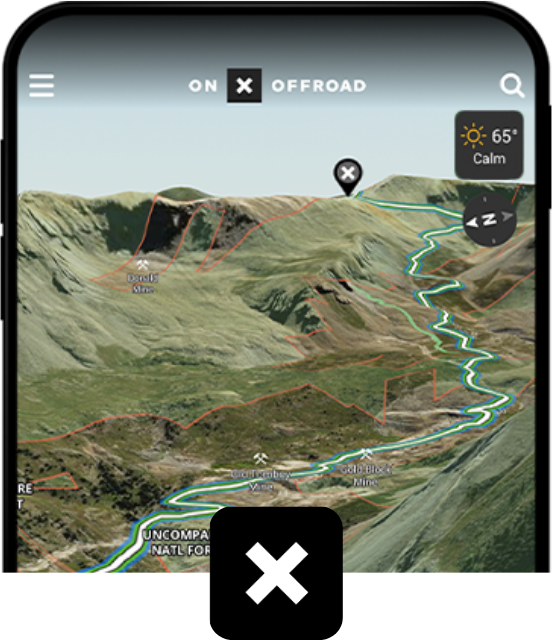
onX Offroad
Go farther with confidence
-
 650K+ Miles of Off-Road Trails
 - Color-Coded Public and Private Land Boundaries
- Dirt Mode and Snow Mode for Year-Round Adventures
- Route Builder and Customizable Map Tools
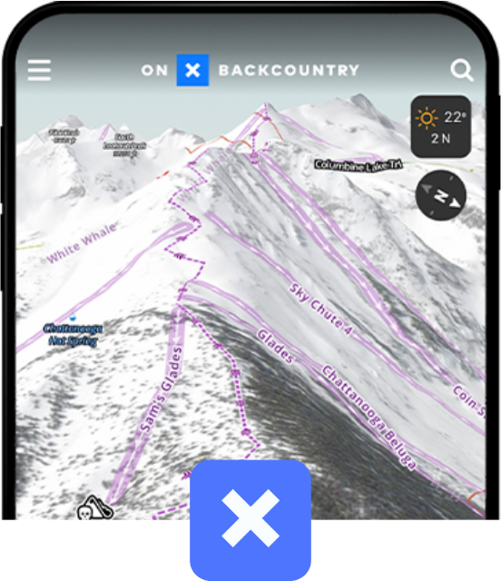
onX Backcountry
Discover trails near you
 770K+ Miles of Hiking, Biking, and Backcountry Skiing Trails
- Color-Coded Public and Private Land Boundaries
- 500K Recreation Points
- Local Weather and Daily Avalanche Forecasts
BLM Area Breakdown
Explore this interactive map below to see the areas outside the park that have the highest concentration of BLM Land
onX Guide to BLM Land Near Zion
Whether you’re looking for established campgrounds or areas that are available for dispersed camping near Zion, your best resource by far is using one of our onX apps to evaluate the area. In all of our apps, you can find current information about public and private land ownership, weather, road conditions, and restrictions (including widths and open/closed dates). And in our onX Backcountry and onX Offroad Apps you can find nearby hiking, biking, and off-roading trails for the region. In all onX apps, BLM public lands are designated by yellow shading.
To get a first-person perspective, we asked some of our experts here at onX for tips and tricks for navigating BLM land near Zion National Park.
- Four BLM-managed Wilderness areas border Zion National Park. The largest is LaVerkin Creek at 445 acres in size. Another nearby BLM Wilderness area is the Goose Creek Wilderness, but it’s only a fourth the size of LaVerkin Creek at 98 acres. As designated Wilderness areas there are usually more restrictions on the types of recreation allowed, such as no motorized travel, so plan accordingly.
- Other popular nearby spots that are not Wilderness areas include Gooseberry Mesa, Sheep Bridge Road, Dalton Wash Road, Burnt Flat Gulch, and Kolob Reservoir.
- Gooseberry Mesa is south/southwest of Zion National Park, near Hurricane. Gooseberry Mesa provides an incredible trail system, primarily for mountain biking, with numerous dispersed camping options.
- If exploring other areas, like Hurricane Cliffs and Sheep Bridge Road, located between State Highways 9 and 59, there are 56 designated dispersed campsites available in this BLM area, but they are out in the open and have no shade. Each site has a numbered placard and metal fire ring. Camping outside of official, designated sites is prohibited. This area is good for those who have medium-clearance vehicles.
- Many of the areas that have free, dispersed camping will require high-clearance vehicles, and the further you go into these areas the easier it will be to find camping. Again, bringing your own water with you is important, as many of the creeks and rivers in this area are unsafe, even if filtered, due to algae and other dangers. Another way natural waters in the area can be a danger is flash floods. Streams and creeks can quickly turn dangerous when it’s raining. Be aware of the warnings and dangers when recreating in these desert landscapes.
- Another thing you should have with you when camping in desert environments is shade. Anything from a tarp off the car, a canopy, or even an umbrella, having shade when the sun’s out and it’s over 100 degrees will keep you safer. One area that offers a handful of shaded BLM campsites is the first mile-and-a-half of Kolob Terrace Road, located just east of the town of Virgin, Utah. These sites can fill quickly but if you can get one it’s pleasant creekside, shaded camping.
The desert lands around Zion National Park are fragile ecosystems. Closely following Leave No Trace principles while recreating on BLM lands in these areas should be standard practice. This includes properly disposing of any refuse, hazardous materials, or sewage you brought into the area; leaving what natural elements you find; minimizing campfire impacts; respecting wildlife; and being considerate of other visitors.
Resources for finding BLM Land
Whether you’re planning a hiking trip, a camping weekend, e-scouting hunting locations, or just looking for a day out in nature, onX Maps is the ultimate resource for BLM land. See our interactive BLM land map where you can search for BLM land near you at onxmaps.com. You can also find BLM land in the following apps:
- onX Hunt – Our most popular app that can also show you the hunting regulations for the surrounding areas and dozens of other layers.
- onX Offroad – In addition to showing you public lands, our Offroad app can also show you all the Offroad trails nearby for your SxS, 4×4, ATV, dirt bike, and snowmobile.
- onX Backcountry – Jam packed with other helpful trail data including several activity modes for Hiking, Backpacking, Climbing, Mountain Biking, and Backcountry Skiing.
Other great resources for BLM land are:
- Recreation.gov – Great for making reservations at busy campsites
- BLM.gov – A simple interactive map that shows BLM Land at a very basic level
Frequently Asked Questions
Bureau of Land Management (BLM) lands are considered public lands. Collectively, they comprise 247.3 million acres and are located primarily in western states.
BLM land on a map is denoted by yellow shading.
The recreational opportunities on BLM lands near Zion National Park mean you can hike, bike, camp for free, and ride OHVs. In fact, off-roading around Zion is one of the most popular activities in the area, with breathtaking views, dunes, and elaborate trail systems. Many already travel to Utah for off-roading because the BLM in the state actively manages nearly 8,000 miles of roads and over 2,000 miles of trails.
And since some of the more popular hiking trails inside Zion National Park require reservations, or permits, or shuttle services to access, having public BLM lands nearby can open up many more opportunities for hiking near the Park itself.
More than 99 percent of BLM land is free to use, unlike national parks and many state parks. Additionally, BLM land can offer more diverse and less-restricted recreational opportunities than national parks or state lands.
See our BLM land maps for Yellowstone National Park and Yosemite National Park.
Call the Bureau of Land Management’s Law Enforcement Dispatch at (800) 637-9152. The number is answered 24 hours a day, 7 days a week, and can be used for reporting issues and natural resources crimes.
There are land-use restrictions in some areas. It’s always best to check with the local BLM field office to learn about permanent, temporary, or seasonal restrictions that may be in place on BLM lands. Remember, BLM lands have specific land management objectives in place to protect resources and provide public safety.