
Off-Road Trails
Near Big Creek, California
Off-Road Trails Near Big Creek, California
Discover the best offroad trails near you. Browse trail maps, check difficulty ratings, and find your next adventure — whether you're looking for a quick ride or an all-day expedition.
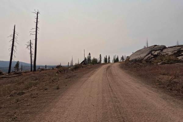
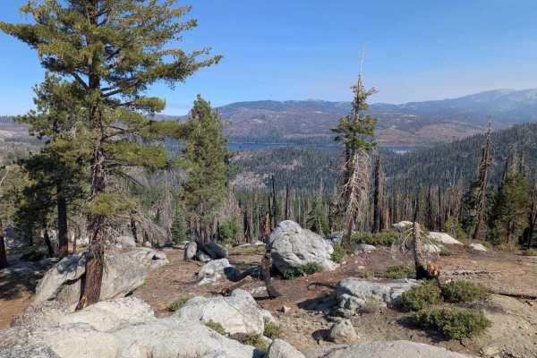
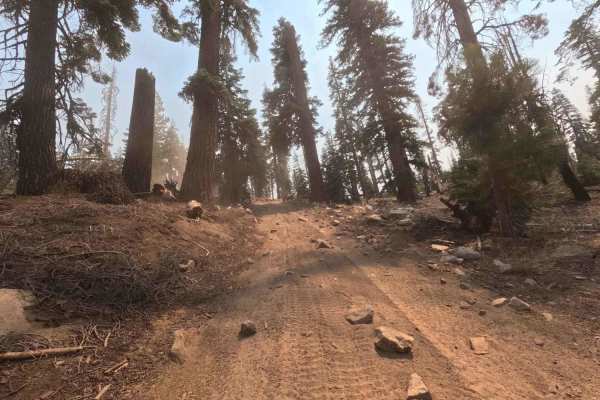
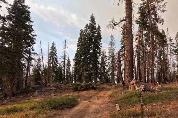
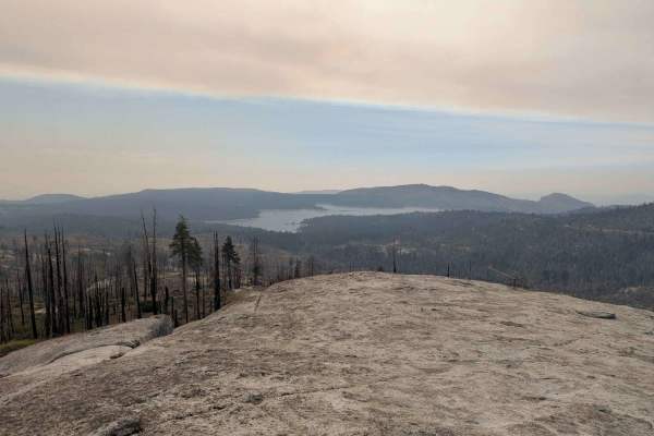
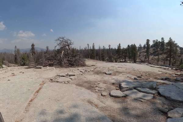
Mountain Top - FS 9S040A
This 0.7-mile trail is a high-elevation, single-lane Forest Service road that connects the top of Lodgepole over to Bawdy around the peak of Tamarack Mountain. The entire trail traverses a highly exposed landscape within the 2020 Creek Wildfire burn scar, creating dramatic vistas but eliminating mos...
Learn more about Mountain Top - FS 9S040A
Red Mountain - FS 8S010
This is a fast, wide, graded forest service road that serves as the essential gateway to the highly challenging Mirror, Strawberry, and Coyote Lakes trail network. This major 6.2-mile high-country road is designed for speed, consisting mostly of fast, wide decomposed granite. However, the path frequ...
Learn more about Red Mountain - FS 8S010
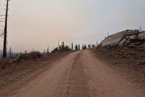
Bawdy - FS 9s040
This 1.6-mile forest service road is a high-elevation, single-lane administrative road designed for access to maintain an overhead power line passing through the area. The entire road traverses a highly exposed landscape within the 2020 Creek Wildfire burn scar, creating dramatic vistas but eliminat...
Learn more about Bawdy - FS 9s040
Upper Tamarack Mountain - FS 9s028
This 1.1-mile two-track is a forest service road that provides a quick transit connector between other roads in this ridge system. The trail runs entirely through a vast, exposed landscape that was severely burned during the 2020 Creek Wildfire. The roadbed is wide and graded, consisting of smooth, ...
Learn more about Upper Tamarack Mountain - FS 9s028
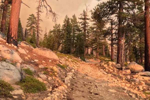
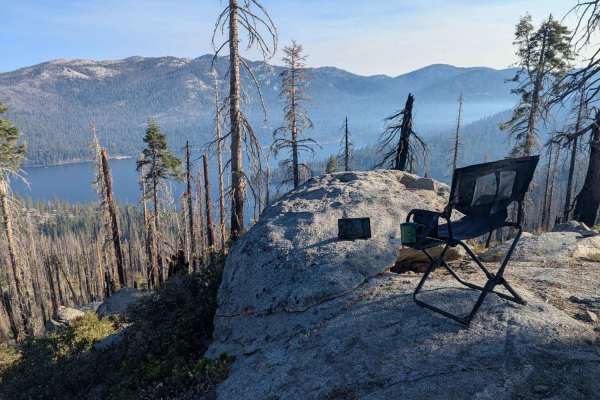
Hewn - FS 25E319
This 0.9-mile two-track is a smooth, easy trail in the high-country road network, serving as a direct continuation of the 8S035 (Boneridge) trail. It leads directly to a large, scenic group campsite located on an exposed granite ridge overlooking Huntington Lake below. The road traverses a mixed-sev...
Learn more about Hewn - FS 25E319
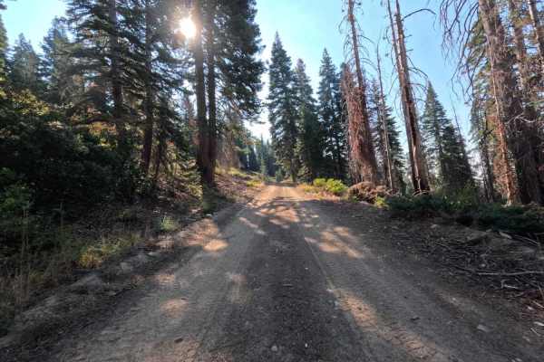
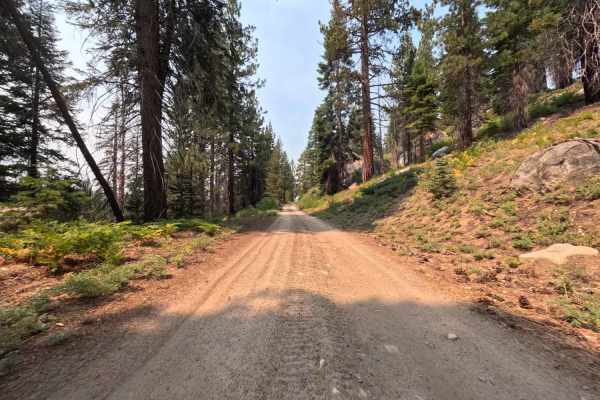
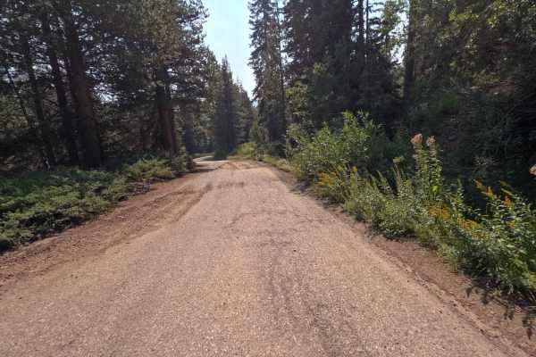
South Fork Tamarack - FS 9s069
This 7.9-mile road is a high-elevation artery providing fast, efficient access to the heart of the high-country trail network, including hiking trails accessing the Dinkey Lakes Wilderness. This road connects between CA 168 and FS 9S009 - Rock Creek Road. The road is a wide, smooth two-lane track wi...
Learn more about South Fork Tamarack - FS 9s069
Boneridge - FS 8s035
This 2.0-mile trail is a smooth and fast single-lane road designed for scenic travel along the ridge, offering expansive views through the open canopy. The roadbed is predominantly composed of well-graded decomposed granite (DG) and packed dirt, making it ideal for covering distance quickly. However...
Learn more about Boneridge - FS 8s035
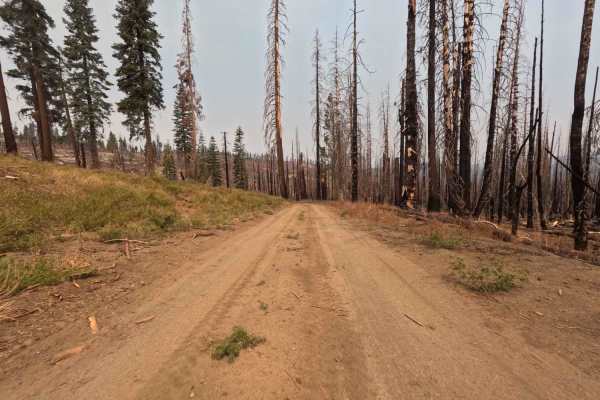
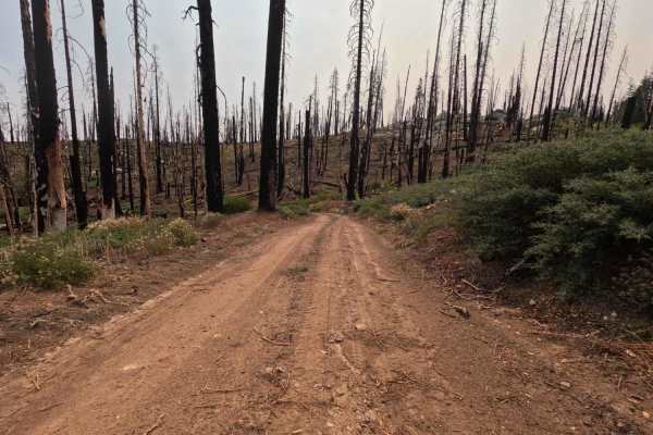
Lower Tamarack - FS 9s026
This is an easy, wide 2.1-mile dirt forest service road designed for fast transit through the high country. The road runs through a massive, high-severity burn scar from the 2020 Creek Wildfire (visible in photos), leaving the area wide open and exposed. The roadbed is predominantly smooth, loose du...
Learn more about Lower Tamarack - FS 9s026
Midnight - FS 9S015
This 2.5-mile two-track trail is a direct and challenging connector for accessing the deeper high-country network between Tamarack Creek and South Fork Tamarack Road. The road is defined by steep, loose climbs where the surface material (mostly dirt and rock) provides poor traction, demanding carefu...
Learn more about Midnight - FS 9S015
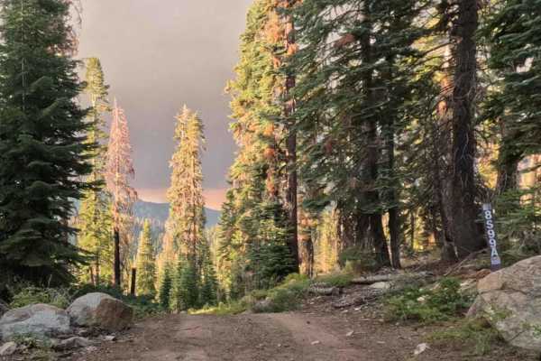
Lodgepole - FS 9s027
This 2.8-mile road is a key connector designed for efficient travel through the high country. The trail is a wide, smooth two-track that traverses a vast expanse of the 2020 Creek Wildfire burn scar (visible in photos), granting incredible exposure and panoramic views. The roadbed is predominantly s...
Learn more about Lodgepole - FS 9s027
Tamarack Creek - FS 9s066
This 1.9-mile road is a dead-end spur. The trail is a clear one-lane track with a smooth, packed dirt and decomposed granite (DG) surface, allowing for quick speeds, confirmed by the efficient travel time. While this area was impacted by the 2020 Creek Wildfire, it avoided the highest severity, leav...
Learn more about Tamarack Creek - FS 9s066
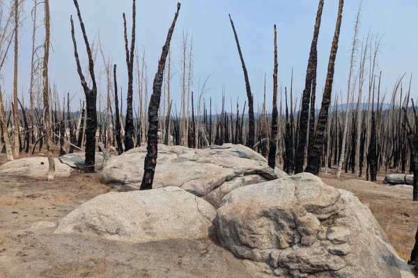
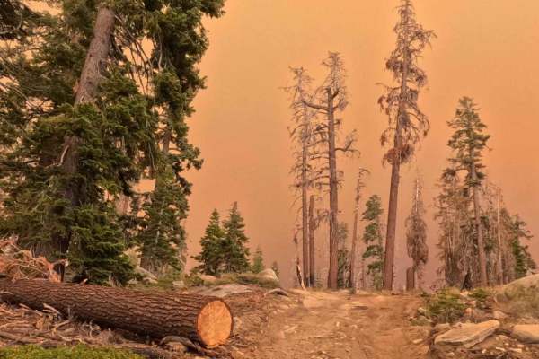
South Tam Trail - FS 25E306
This challenging two-track technical trail is a dramatic traverse defined by extreme post-fire devastation. The track constantly alternates between sections of loose dirt, DG, and exposed granite rock. The sparse canopy reveals a stark forest of silver and blackened standing snags. The 1.4-mile trav...
Learn more about South Tam Trail - FS 25E306
Snow Drift - FS 8s098
This is a fun, scenic, and easy 2.4-mile forest service road that climbs onto a ridge offering spectacular, high-elevation vistas, including an overlook of Huntington Lake and the nearby China Peak Ski Resort. The road surface is generally wide and fast, consisting primarily of smooth DG and packed ...
Learn more about Snow Drift - FS 8s098
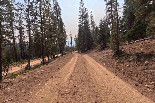
Rock Creek Road - FS 9S090
Rock Creek Road (FS 9S090) is the essential spinal cord of the Bald Mountain OHV area, a 12.7-mile journey that changes its personality more often than a moody teenager. Connecting Highway 168 at the Tamarack Ridge Snowpark to Dinkey Creek Road, this route is the primary artery for accessing the reg...
Learn more about Rock Creek Road - FS 9S090
Snowball - FS 8S099
This is an easy, fast 2.3-mile forest service road that provides efficient transit from the high ridge network back down toward Highway 168. The road is a clear two-track with a primarily packed dirt and loose aggregate surface, allowing for fast descending speeds. The trail passes through a mixed-s...
Learn more about Snowball - FS 8S099
Raccoon - FS 26E336
This is an extremely short, single-lane 0.4-mile trail that connects to Gooseneck to create a longer connection between the Barbecue (8S056) route and the Snow Drift (8S098) road. The trail traverses a scenic, high-elevation area, transitioning through patchy sections of the 2020 Creek Wildfire burn...
Learn more about Raccoon - FS 26E336
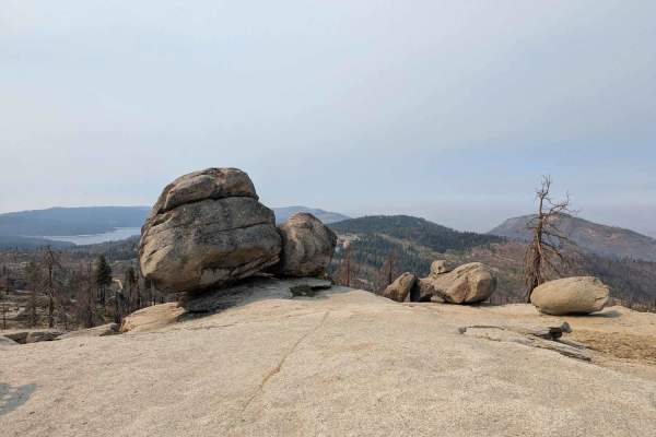
Azalea Creek - FS 9S014B
This is an essential, short 1.1-mile spur providing high-clearance access to a unique ridge-top viewpoint. The trail climbs rapidly through a mixed-severity 2020 Creek Wildfire burn zone, which has exposed the dramatic granite formations and opened up panoramic views. The surface is a mix of rock an...
Learn more about Azalea Creek - FS 9S014B
Lower Tamarack - FS 9S014
This is an easy, short 2.6-mile spur that leads to a scenic access at a spectacular campsite at a rock grouping above Azeala Creek with regional views out over Shaver Lake. The trail is a loose two-track running through the highly exposed 2020 Creek Wildfire burn scar. The surface is loose dirt with...
Learn more about Lower Tamarack - FS 9S014
Upper South Fork Tamarack Creek - FS 9s023
This is a challenging, 2.2-mile drive defined by extreme surface conditions and environmental hazards. The route begins briefly in a healthy, shaded stand of trees before immediately entering a vast, exposed burn scar from the 2020 Creek Wildfire. The roadbed here is composed of deep, loose duff (de...
Learn more about Upper South Fork Tamarack Creek - FS 9s023
Snow Drift Spur - 8s098h
This is the perfect high-reward, low-effort trail for reaching a prime campsite. This extremely short 0.35-mile spur quickly climbs off the main ridge track (8S098) and dead-ends at a stunning viewpoint overlooking Huntington Lake and the valley below. The road is a narrow two-track, characterized b...
Learn more about Snow Drift Spur - 8s098h
ATV trails near Big Creek, California
Explore ATV-friendly trails near you. These trails are accessible for vehicles up to 50 inches wide, perfect for ATVs and smaller off-road machines.
Bow Tie - FS 25E208
Bow Tie (FS 25E208) is a classic High Sierra connector that feels like a "greatest hits" album of the Bald Mountain region. Starting from Rock Creek Road, this trail winds south, linking up with Tower (FS 25E314) and eventually terminating at Plain (FS 25E315). The tread is that signature Sierra mix...
Learn more about Bow Tie - FS 25E208
Strawberry Lake - FS 26E214
Strawberry Lake Trail (FS 26E314) is a trail that lures you in with a smile before baring its teeth. Departing from the Sand Flats Staging Area, the route begins deceptively mellow, offering a gentle warm-up as you cruise toward the intersection with the Mirror Lake Trail (FS 26E216). However, once ...
Learn more about Strawberry Lake - FS 26E214
Brewer Lake
If you are a beginner, or looking to test out a new vehicle, this is a great easy trail. The trail is short but provides beautiful views of Shaver Lake below. The last three quarters of a mile will appeal to those looking for a challenge. Great campspots available.
Learn more about Brewer Lake
UTV/side-by-side trails near Big Creek, California
Find UTV and side-by-side trails near you. These trails accommodate vehicles up to 60 inches wide, ideal for UTVs, side-by-sides, and wider off-road rigs.
Bow Tie - FS 25E208
Bow Tie (FS 25E208) is a classic High Sierra connector that feels like a "greatest hits" album of the Bald Mountain region. Starting from Rock Creek Road, this trail winds south, linking up with Tower (FS 25E314) and eventually terminating at Plain (FS 25E315). The tread is that signature Sierra mix...
Learn more about Bow Tie - FS 25E208
Strawberry Lake - FS 26E214
Strawberry Lake Trail (FS 26E314) is a trail that lures you in with a smile before baring its teeth. Departing from the Sand Flats Staging Area, the route begins deceptively mellow, offering a gentle warm-up as you cruise toward the intersection with the Mirror Lake Trail (FS 26E216). However, once ...
Learn more about Strawberry Lake - FS 26E214
Brewer Lake
If you are a beginner, or looking to test out a new vehicle, this is a great easy trail. The trail is short but provides beautiful views of Shaver Lake below. The last three quarters of a mile will appeal to those looking for a challenge. Great campspots available.
Learn more about Brewer Lake
The onX Offroad Difference
onX Offroad combines trail photos, descriptions, difficulty ratings, width restrictions, seasonality, and more in a user-friendly interface. Available on all devices, with offline access and full compatibility with CarPlay and Android Auto. Discover what you're missing today!
Open Trail Map