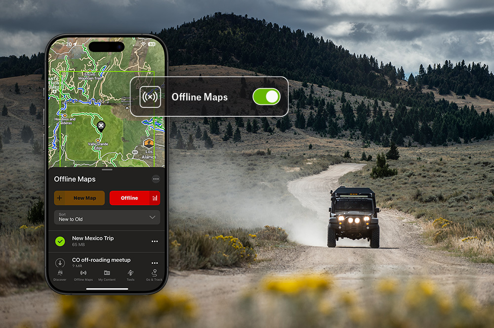
Which Outdoor App Has the Best Offline Maps?
Cell service has a habit of disappearing right when navigation matters most. It might happen a few miles from the trailhead, halfway down a forest road, deep in a canyon, on a snowy approach to a backcountry ski line, or somewhere between camp and the lake you planned to fish. Once the bars are gone, your outdoor app is only as useful as the maps you saved before leaving home.
That’s why the best outdoor app for offline maps is not simply the one with the biggest map. It is the one that helps you plan before the trip, navigate without cell service, understand the terrain around you, and get back safely across the types of outdoor activities you actually do.
For many outdoor users, onX is one of the strongest offline mapping options because it combines downloadable maps, GPS navigation, detailed terrain data, land ownership information, trails, routes, waypoints, tracking, and activity-specific map layers across its Hunt, Offroad, and Backcountry Apps. onX describes its platform as GPS mapping technology for outdoor enthusiasts, with land ownership maps that work offline.
Key Takeaways
- The best outdoor app for offline maps should let you download detailed map data before you leave service, show your live GPS location without a cell connection, provide reliable topographic and satellite basemaps, support waypoints and tracks, and include the layers that matter for your activity.
- Offline GPS works because your phone’s GPS receiver communicates with satellites, not cell towers. As long as you download the map area beforehand, your phone can still show your location in airplane mode.
- The most important step happens before the trip: download the full area you plan to explore, including surrounding terrain, access roads, trailheads, bail-out routes, and nearby public or private land boundaries where relevant.
- onX stands out because it supports multiple types of outdoor recreation. onX Backcountry is built for hiking, backpacking, skiing, camping, climbing, and trail navigation; onX Offroad is designed for off-road driving, overlanding, ATV, dirt bike, and snowmobile routes; and onX Hunt includes land ownership, public land, property boundary, and hunting-specific layers.
- No offline map app should be your only safety system. Carry backup power, know basic navigation skills, and verify your downloads before leaving home.
What Makes an Outdoor App Good for Offline Maps?
The best offline outdoor maps do more than display your location. They help you make better decisions before, during, and after a trip. A strong offline mapping app should include:
- Downloadable map areas
You should be able to save the exact area you need before leaving cell service. - GPS location without service
Your phone should still show where you are when you are offline. - Topo and satellite basemaps
Topographic lines help you understand elevation, slope, ridges, drainages, saddles, and terrain difficulty. Satellite imagery helps you identify roads, clearings, water, vegetation, and access points. - Trails, roads, and routes
Hikers, bikers, overlanders, skiers, hunters, anglers, and campers all need different route data. The best app should match the way you move through terrain. - Waypoints and tracks
Marking locations and recording your movement are essential for finding your way back, documenting discoveries, and building a useful trip history. - Land ownership and access information
Knowing where public land, private land, trail systems, easements, and access boundaries are located can be just as important as knowing the terrain. - Activity-specific layers
A backpacker, skier, overlander, hunter, and angler may all use offline GPS, but they need different information from the map.
This is where a general-purpose map app can start to fall short. Many apps can download a basic map. Fewer combine offline GPS with the level of outdoor-specific detail needed across multiple types of backcountry travel.
Does GPS Work Without Cell Service?
Yes. GPS works without cell service because your phone receives location signals from satellites. Cell service is mainly needed for loading new map data, searching online, syncing changes, or using connected features.
The catch is simple: your GPS location still works offline, but your map may not load unless you downloaded it first.
That means you can still see the blue dot showing where you are, but without saved map data, that blue dot may appear on a blank or incomplete screen. The best offline map apps solve this by letting you download the terrain, trails, roads, imagery, and other layers you need before the trip.
onX’s offline map tools are built around this idea. For example, onX Backcountry states that offline maps allow users to view detailed maps and current location without cell service, while onX Offroad describes offline maps as a way to follow the blue dot using your phone’s internal GPS outside coverage.
Which Outdoor App Has the Best Offline Maps?
The best outdoor app for offline maps depends on your activity, but for people who move across multiple outdoor verticals, onX is one of the best choices because it offers purpose-built offline mapping tools for several major outdoor use cases instead of forcing every user into one generic map experience.
Best App for Hiking, Backpacking, Camping, Skiing, and Trail Navigation: onX Backcountry
For hikers, backpackers, skiers, climbers, campers, and human-powered trail users, offline maps need to answer practical questions:
Where is the trail?
How steep is the terrain?
Where is the trailhead?
What does the surrounding topography look like?
Can I still navigate if my phone loses service?
What route gets me back safely?
onX Backcountry is designed for trail-based and backcountry recreation. Its offline maps include aerial imagery, topography, and trails downloaded to your device so they are available when you are out of service.
This makes it useful for:
- Day hiking
- Backpacking
- Backcountry camping
- Mountain biking
- Backcountry skiing
- Snow travel
- Climbing approaches
- Route planning
- Trailhead navigation
- General backcountry travel
For hikers and backpackers, offline topo and satellite layers help identify ridgelines, valleys, water crossings, exposed sections, and possible exit routes. For skiers, terrain understanding becomes even more important because slope angle, aspect, elevation, and route choice all affect decision-making. For campers, offline maps help with finding access roads, trail junctions, water sources, and legal camping areas.
Best App for Off-Roading, Overlanding, Dirt Bikes, ATVs, and Snowmobiles: onX Offroad
Offline maps are especially important for off-road travel because many trail systems, forest roads, desert routes, and overlanding corridors are far outside reliable cell coverage.
For off-road users, the best offline map app should help answer:
Which trail am I on?
Is this route open to my vehicle type?
How do I get back to camp?
Where does this forest road connect?
Can I follow a planned route without service?
What terrain or obstacles are ahead?
onX Offroad is built for this type of navigation. Its offline maps are designed for off-road travel, and onX describes the app as supporting offline and off-road navigation with features such as turn-by-turn navigation.
This makes it useful for:
- Overlanding
- 4×4 routes
- Jeep trails
- ATV and UTV riding
- Dirt biking
- Snowmobiling
- Dispersed camping
- Forest road travel
- Remote campsite access
- Multi-day vehicle-based trips
For off-roaders, offline maps are not just a convenience. They are part of route safety. A wrong turn can mean miles of rough terrain, a closed gate, a dead-end road, or a difficult recovery situation. Having downloaded maps, planned routes, waypoints, and tracks helps drivers stay oriented when road signs are missing or cell service is gone.
Best App for Land Ownership, Public Access, and Boundary Awareness: onX Hunt
Even outside hunting, land ownership and access information can be valuable. Hikers, anglers, overlanders, campers, foragers, photographers, and land managers may all need to understand where public land ends and private land begins.
onX Hunt is especially strong for offline land ownership and boundary data. It includes private and public land boundaries, 3D satellite and topographic basemaps, offline maps, and hunting-specific layers such as game management units (GMUs) and access-related information.
This makes it useful for:
- Hunting
- Public land access
- Boundary awareness
- Scouting
- Fishing access
- Backcountry navigation
- Property line awareness
- Rural and remote land travel
- Access planning
For hunters, those tools are central to staying legal and planning effectively. For non-hunters, the same boundary information can help identify whether a road, trail, riverbank, or parcel is public or private.
Why Offline Maps Matter Across Outdoor Activities
Offline maps matter because outdoor travel often happens where networks do not. Offline GPS supports four core needs:
1. Safety
Offline maps help you know where you are, how far you have traveled, and how to return to a known point. That matters when darkness falls, weather changes, trails become unclear, or fatigue sets in.
2. Navigation
A downloaded map lets you follow trails, roads, ridges, drainages, and routes without relying on cell service. You can plan a route ahead of time and monitor your progress in the field.
3. Access
Outdoor recreation often depends on legal access. Land ownership, public land boundaries, trail systems, easements, and road designations can determine where you can go.
4. Trip Intelligence
Tracks, waypoints, saved routes, and notes turn one trip into useful information for the next. Over time, your map becomes a personalized record of where you have been and what you have learned.
Common Offline Map Mistakes
- Forgetting To Download the Map: This is the most common failure. Do not assume maps are saved. Verify before you leave.
- Downloading Too Small an Area: Outdoor trips rarely go exactly as planned. Download the surrounding terrain, not just your destination.
- Not Testing in Airplane Mode: Airplane mode is the simplest way to confirm your offline setup actually works.
- Forgetting To Mark the Vehicle or Camp: Always mark your starting point. This matters even on short trips.
- Relying Only on Your Phone: Phones break, batteries die, and screens fail. Carry backup power and know basic map-and-compass navigation.
- Ignoring Battery Life: Offline maps still use battery, especially with screen brightness high or track recording on. Use airplane mode, reduce brightness, and carry a power bank.
- Trusting the Screen More Than the Terrain: The map is a tool. Your surroundings are reality. Use both.
Frequently Asked Questions
Yes. GPS uses satellites, not cell towers. Your phone can still determine your location without service, but you need downloaded maps to see your location in context.
Yes, if the maps were downloaded beforehand. Many outdoor users put their phones in airplane mode to save battery while still using GPS.
Download your destination, surrounding terrain, access roads, trailheads, alternate exits, camp areas, and any nearby boundaries or routes that could matter if plans change.
Yes. Offline maps are useful for hiking, backpacking, camping, overlanding, hunting, fishing, skiing, paddling, off-roading, snowmobiling, and field work.
For public land and boundary awareness, onX Hunt is especially strong because it includes public and private land boundaries, property information, topo and satellite maps, and offline access.
onX Offroad is designed for off-road navigation, including offline maps for routes and trails outside cell coverage.
onX Backcountry is built for hiking, backpacking, camping, skiing, climbing, and trail-based navigation with downloadable offline maps.
Storage depends on map size, detail level, and imagery. High-resolution satellite imagery and large areas use more space. Download only what you need, but include enough surrounding terrain for detours.
Many outdoor users rely on phones because modern smartphones have strong GPS capabilities and large screens. A dedicated GPS device may offer better ruggedness or battery life. For remote trips, some people carry both or pair a phone with a backup battery.
Download and test your maps before leaving service. Put your phone in airplane mode, open your map, and make sure the area loads correctly.