Easement Data in the Mountain-West Reveals Public Land Access Routes
Ever look at a map and wonder “How can I get to that piece of public land?” The answer may have, until recently, been tucked away in a Bureau of Land Management (BLM) or United States Forest Service (USFS) filing cabinet or may still be waiting there to be re-discovered.
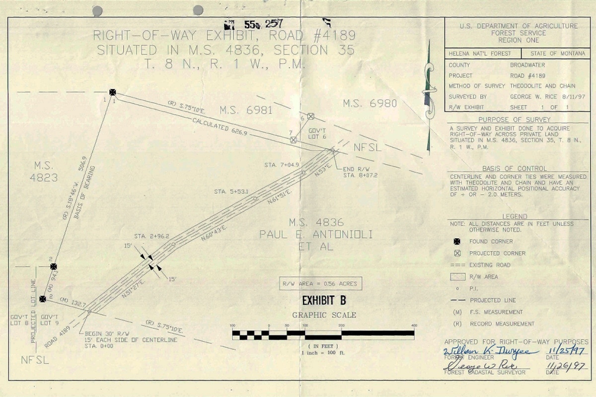
Since the late 1800s, the federal government has negotiated with landowners for permanent access and right-of-way easements securing the right to travel through a property for access to public lands. Though many of these easements were made with private landowners, easements between governmental agencies also exist and will continue to protect access even if the land is transferred out of public ownership.
What exactly is an access or right-of-way easement? In the simplest terms, an easement is the legal right to use another’s property for a specific purpose. Access and right-of-way easements specifically grant the holder the right to travel through another’s property. The most common form of public right-of-way is a road or path through a parcel of land in order to access a public area. Though some government-held easements are restricted to administrative use only, many grant the general public the right to use them. There are tens of thousands of these easements filed away as part of land sales or land swaps. However, since many easements were recorded before computers existed, finding a public easement can require a lot of research for agency personnel and the public alike. Digitization efforts by the BLM and USFS are slowly making that process easier. However, there is no single, convenient location for the public to find this information, and onX aims to change that.
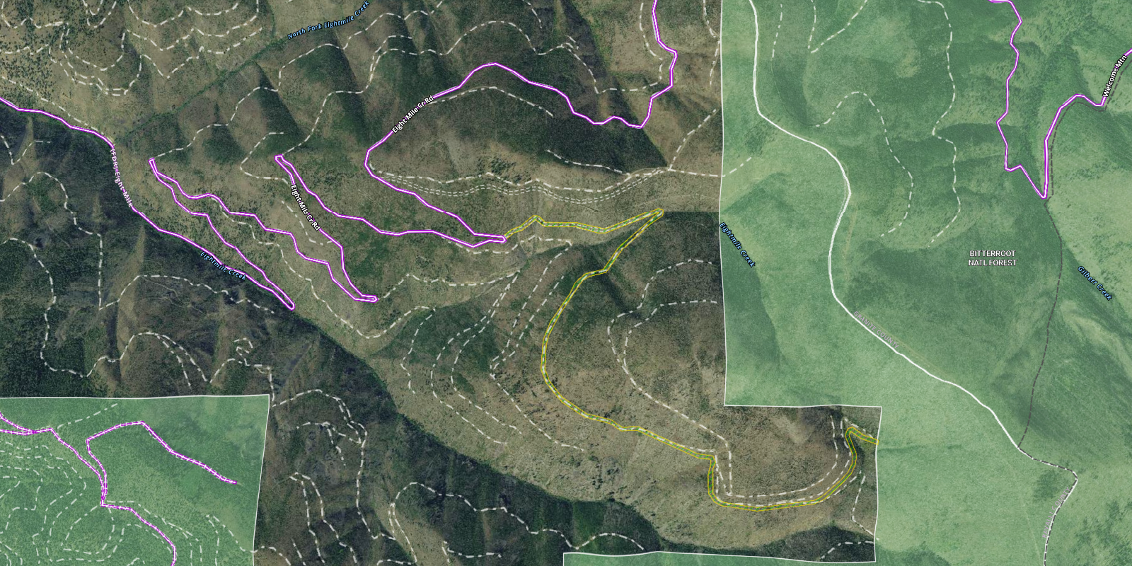
With
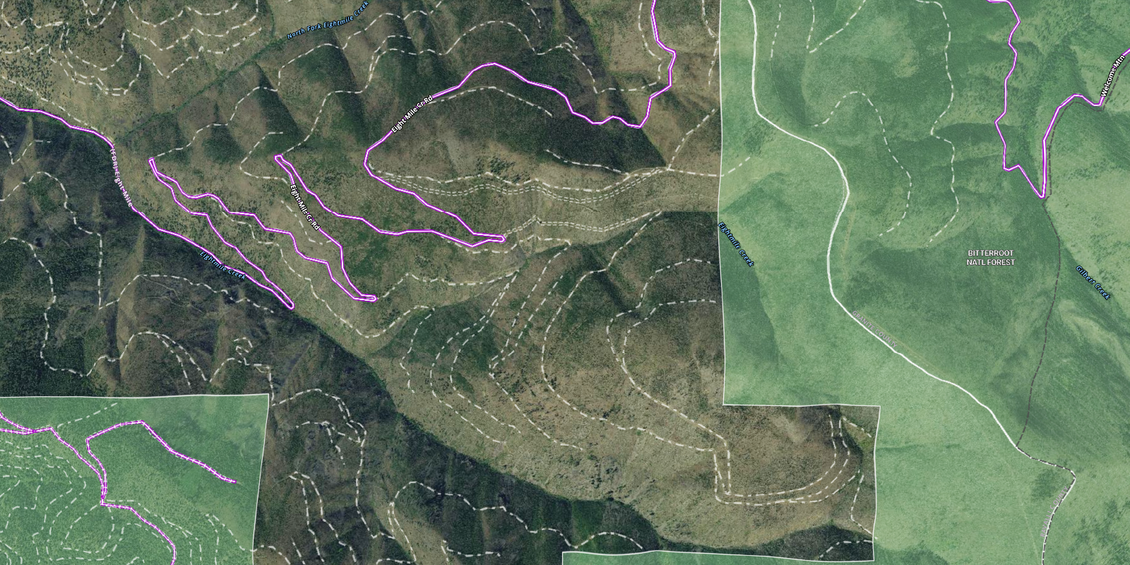
Without
A Quick History of Inaccessible Public Land
Even before the pandemic that spurred an uptick in outdoor recreation across our country—and the ensuing overcrowding in many areas—there was a burgeoning interest in improving access to hard-to-reach public lands. One challenge faced by outdoor enthusiasts is limited access points to large tracts of BLM and USFS lands, making thousands of acres difficult to reach. Though these lands are legally accessible, in many places the land is physically inaccessible to all but the most intrepid outdoor enthusiasts due to long distances, cliffs, rivers, or ravines.
Secondly, in the West a significant amount of federal and state lands cannot be accessed without getting permission from a neighboring private land owner. These areas are federally or state-owned land surrounded by private land and effectively cut off, or “landlocked” by private land. As detailed in a series of five reports published by the Theodore Roosevelt Conservation Partnership and onX, most of these islands of public land arose from the homesteading days of the late 1800s and early 1900s. During this time, the federal government encouraged citizens to stake claims to become self-sustaining farmers, and granted millions of acres of non-adjoining sections of land to railroad companies and newly-established states in an effort to expand the country Westward. However, millions of acres reverted to government ownership when farmers abandoned their homesteads because they could not make a living in the arid, rugged West and when railroad companies forfeited land grants for a variety of reasons. These generally isolated and disjointed tracts of land are now managed by the BLM, USFS, and state land boards, and create a patchwork of intermixed federal, state, and private land. Though not all of these federal and state landlocked lands have access easements to reach them, there are some that do.
BLM and USFS Rights-of-Way
As a result of the heightened interest in public access to public lands, the BLM decided to dust off some of these files and completed a pilot project in 2019 in the Montana/Dakotas District to digitize their road and trail access easements. Digitizing is the process of converting the recorded paper documents into a format that can be processed by a computer. In this case, the legally perfected easement deeds are converted into data that can be used to create an online map. This data was recently published on their website, and plans are in the works for other districts to follow suit.
Likewise, the USFS has been working on digitizing its easements including rights-of-way throughout their regions over the last several years. In February of 2020, a group of onX geospatial analysts had the opportunity to meet with local Forest Service personnel in Region 1 who are tasked with this effort, to learn about the complexities of this work. The process of combing through historical documents and deeds, deciphering the notes, legally verifying the records, and then digitizing the data in the correct location can be difficult and time consuming. It may take hours to days to accurately digitize one easement. The time required from start to finish depends on the comprehensiveness and accuracy of the records that are available, and how well the information recorded decades ago matches the current on-the-ground realities of today.
With limited resources available, the process of digitizing all easements recorded by federal land management agencies could take decades. However, this timeline may be greatly decreased thanks to recently-passed legislation. The Modernizing Access to Our Public Land Act, also known as the MAPLand Act, requires federal easement records, along with other land and water access data, to be made available to the public in a digital format within three years. Funding for this effort will be provided to the Departments of Interior, Agriculture, and Army to accomplish this task.
onX and Rights-of-Way
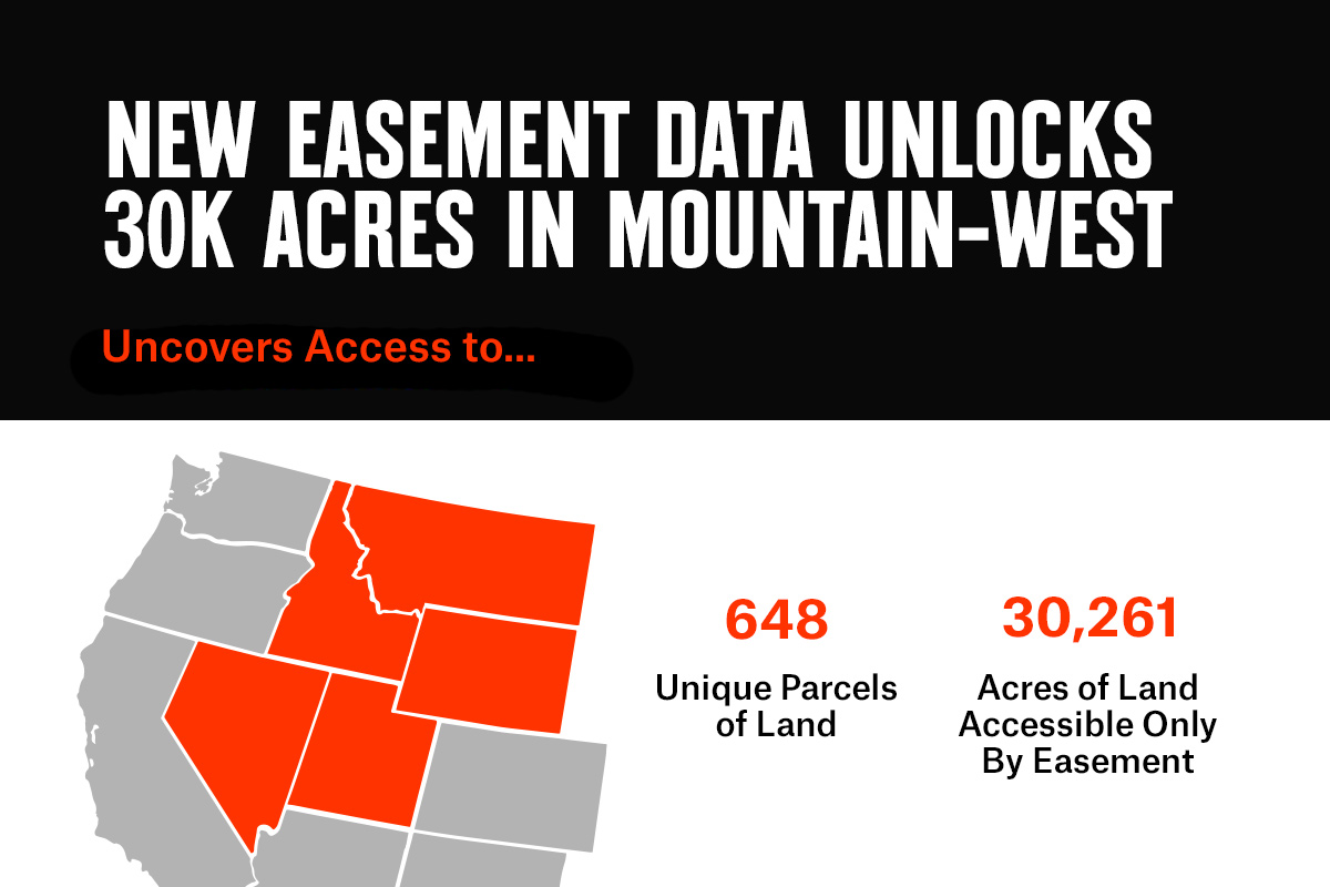
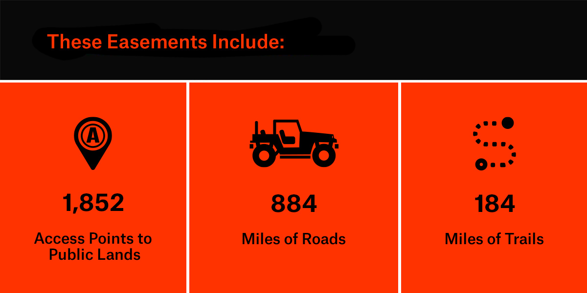
onX now has the means to display this digitized data in our Apps with the online publication of the verified access easements by the BLM Montana/Dakotas District Office and rights-of-way easement data available from the USFS. This data is especially useful for finding new access opportunities in remote public lands. To date, onX has incorporated USFS data for Montana, Idaho, Nevada, Utah, and Wyoming, in addition to the BLM data from the Montana/Dakotas District Office, but coverage will continue to expand as additional data is sourced and curated.
The BLM is very excited to see public lands access data for Montana incorporated into the onX Hunt App. onX continues to be a strong BLM partner and advocate for public land access, and adding this data puts new information at the fingertips of an increasing number of hunters and recreationists. We’re looking forward to providing the same information to even more Western states in the coming years!
Adam Carr, Public Access Project Manager,
BLM Montana/Dakotas District
This initial set of data has yielded some surprising results. Over 648 unique tracts of public lands have been determined to have additional access points. This includes more than 30,261 acres of public land that we previously identified as landlocked, as they had no digitized public route for access available when we conducted our analysis. Now that these easements have been transferred from the drawers of the filing cabinets to the digital world, we are able to produce a more comprehensive landlocked dataset. As additional data is published we will continue to refine our results.
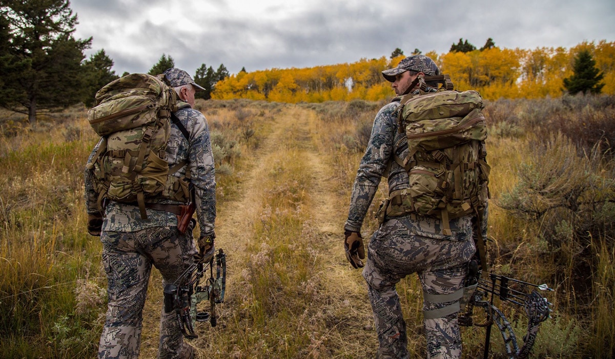
Using Rights-of-Ways When Hunting and Exploring
If you open your onX Hunt App to begin scouting your next outdoor adventure, and you see an access easement or right-of-way that will get you to where you want to go, there are a few points to keep in mind.
- Since the establishment of these easements range from this year to over a hundred years ago, the trail or road they are based on may be barely visible or even non-existent. There are cases where an easement was established for future plans to develop a road or trail that never came into fruition. In other places, the route may have seen very little use over decades and therefore is no longer evident on the land. Therefore, don’t assume that all “road” rights-of-way or access easements are passable using a vehicle, or that you will find a clearly marked or maintained trail on a “trail” right-of-way or access easement.
- Secondly, some of these easements may not have been used by the public for decades; effectively forgotten by the public and landowners alike. Furthermore, private land ownership may have changed hands, possibly many times since the easement was recorded. Current landowners may not know about these easements and may be surprised by members of the public crossing their property. If a route is obscured, posted, or gated, don’t assume that the landowner is knowingly blocking a public right-of-way. Instead, if you come across a gate or sign, ask the landowner for permission to use the easement or contact the agency that holds the legal record to address the situation.
- Finally, remember that these easements are only for allowing passage across a piece of private property to access public lands. They are not for hunting, fishing, wildlife viewing, or recreation. So, keep moving and respect the private property rights as you would on any other piece of private property.
To avoid clutter and confusion on the map, we chose only to display easements that cross private property and provide access to public lands. There are also some easements shown that cross privately-owned lands open to the public, for example lands owned by The Nature Conservancy or a timber company. In these instances, you should check with the organization or company regarding their land access regulations and policies before venturing off the easement.
What Comes Next
We are excited to highlight these access easements and rights-of-way in the Mountain-West, and we will keep adding to our inventory as more data becomes available from the Bureau of Land Management and U.S. Forest Service. Stay tuned as we reveal more public access routes in the coming years!