Access and Stewardship Initiatives: A Quick Update
Over four years ago, onX determined the best way to give back to our customers was to promote and support access to hunting and outdoor recreation. After all, the mission of onX is to awaken the adventurer inside everyone. But access to outdoor adventure can be threatened by industrial development, land changing ownership, suburban sprawl, public land policies, user group disagreements, or misuse and abuse that leads to closures. Our current and future outdoor recreation and hunting opportunities are being fragmented, scaled down, and lost. At the same time, the popularity of outdoor activities is increasing, so stewardship of the land and resources that we do have access to is ever more critical.
That’s why we are committed to leveraging our strengths to help protect the access to outdoor recreation that exists and advocate for more, for everyone. With 2021 in the rearview mirror, we wanted to update you on what we’ve been working on since our three-year advocacy summary was published in December of 2020.
Supporting Access and Stewardship Projects
By the end of 2020, our project partners had secured 14,473 acres for public access, which, due to the proximity to other limited-access public lands, facilitated improved access to an estimated 9,778 additional acres in Montana, Oregon, Arizona, and Iowa. To see where projects we’ve supported are located, check out our Completed Access and Stewardship Projects map.
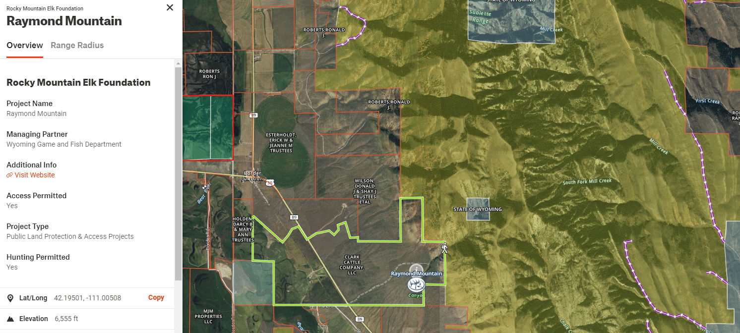
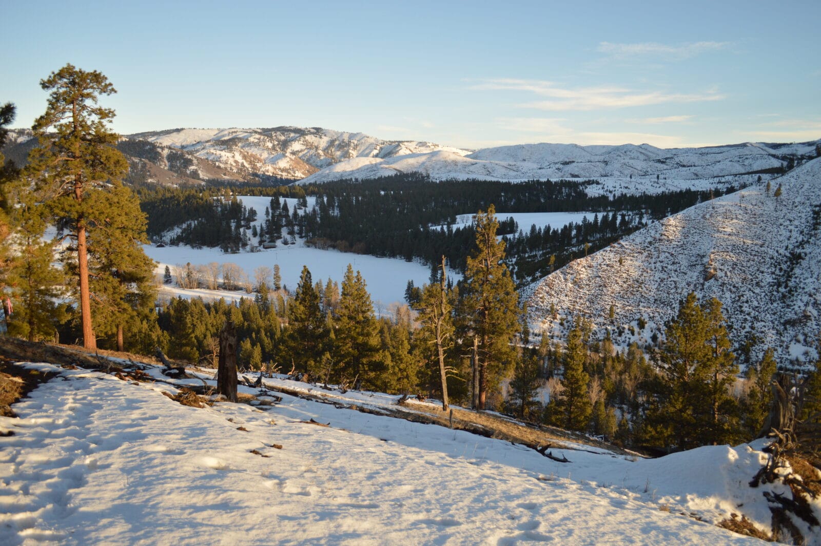
Early in 2021, the Rocky Mountain Elk Foundation finalized an agreement between a landowner, the Wyoming Game and Fish Department, and the Bureau of Land Management to create a new public access point to the Raymond Mountain Wilderness Study Area. With support from onX, Bass Pro Shops and Cabela’s, 32,900 contiguous acres of public land are now accessible from the southwest side of the Sublette Mountains. Check out the new access point in the Rocky Mountain Elk Foundation layer in the onX Hunt app.
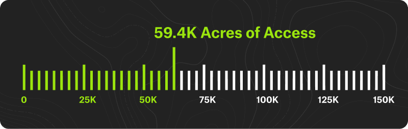
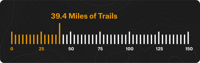
A few months later, we decided to set an ambitious pair of goals: by 2023, we will help secure or improve public access to 150,000 acres of land for public access, and we will help restore, secure, or build 150 miles of trails. You can track our progress towards these goals on our Access Initiatives page.
In order to meet these goals, we opened our new Access + Stewardship Grants program to land trusts, trail associations, and other organizations working to preserve and expand outdoor recreation opportunities. In the first two rounds of grant reviews, we received more than 55 applications from 25 states.
From those applications, we selected eight new projects to support around the country. Since many land acquisition and trail projects take years to finalize, we’ll be announcing details of the projects we selected in 2021 over the next two years. For now, we are pleased to announce two of the projects selected for our Access + Stewardship Grants:
- The Richardson Property in Northfield, Massachusetts, permanently preserves a stretch of the New England National Scenic Trail, as well as a mixed-use trail to the viewpoint on Stratton Mountain. For decades, the landowners dutifully cared for the 38 acres and built trails, a hiker’s cabin, and tent platforms but recently decided it was time to sell. Luckily, Mount Grace Land Conservation Trust was able to purchase the property and will ensure the land continues to be enjoyed by day hikers, backpackers, hunters, skiers, and horseback riders. Because of the property’s location adjoining state forest land, the project will maintain a critical access point to hundreds of acres of public land and dozens of miles of trails.
- The C. Ben White Memorial near Conner, Montana, consists of 97 acres of riparian habitat and upland forest along the Bitterroot River. The Bitter Root Land Trust recently purchased the property and transferred the land to Montana Fish, Wildlife & Parks. The location of the site affords the public with a new access point to the river for fishing, launching rafts and paddleboards, and walking along the water. The property adjoins National Forest land and a new trail is being constructed up a rugged mountainside to give hikers, mountain bikers, horseback riders, and hunters a convenient access point into a vast network of forest roads and trails. The new trail and trailhead area will be completed in spring 2022.
Progress Toward Our 2023 Goals
The acres of land and miles of trails these projects secure mean that in total, since 2018, our project partners have increased or improved public access to 59,400 acres and 39.4 miles of trails.
In addition, we began to invest in stewardship initiatives in 2021. During Great Outdoors Month in June, proceeds from the sale of onX Backcountry went to the Leave No Trace Center for Outdoor Ethics. This donation raised awareness of the Seven Principles of Leave No Trace as summer recreation ramped up, and a portion of the money will help support the Center’s Hot Spots program.

New Data in onX Hunt
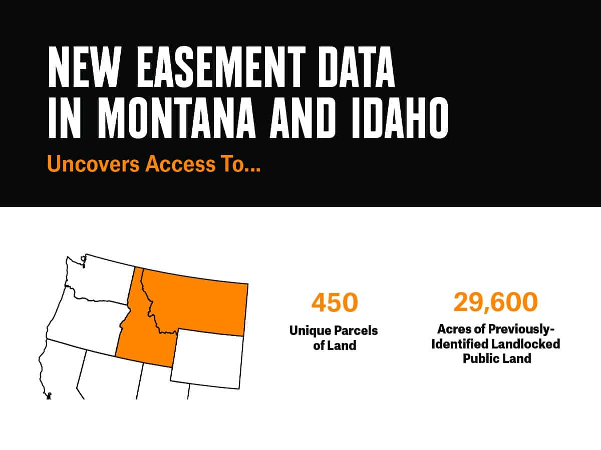
Supporting new access and stewardship projects may be our passion, but our business is also focused on providing the best navigation information for outdoor enthusiasts. For that reason, we began integrating public easement data held by the Bureau of Land Management and the United States Forest Service into our Hunt App. These are road and trail routes across private land that the public can utilize to reach adjoining public land. In the Fall of 2021, we added location information for routes in Montana and Idaho that reveal access to 29,600 acres of otherwise inaccessible public lands, meaning that without these access routes, these public lands would be landlocked.
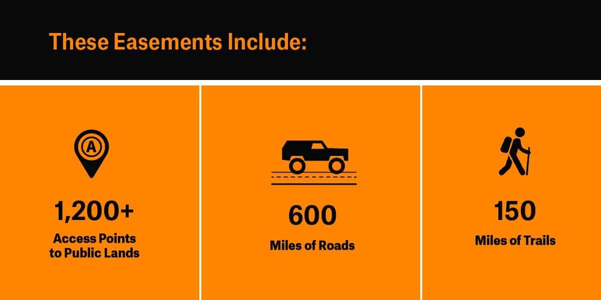
Many more easement records are currently only available in paper files stored at the land management agency offices. As the agencies continue to digitize these records, onX will add the data to our Hunt App across more areas of the country, potentially revealing several thousand more acres of public land that are open to the public even though they are bordered by private land. For the full history, as well as some important things to keep in mind when utilizing these easement routes, check out our story: Easement Data Unlocks Public Land.
New Analyses and Perspectives
From 2018 to 2020, much of our focus was on bringing awareness to “landlocked” public land—public land parcels that are surrounded by private property. But last year we began to think about public access in new ways. We interviewed the directors of two programs that provide financial benefits to private landowners who open their properties during hunting season. Programs like the Montana Block Management Areas and the South Carolina Wildlife Partnership keep private land on the local tax rolls, provide a financial benefit for the private landowners who voluntarily participate, and provide hunters with more opportunities to find game, a win-win-win.
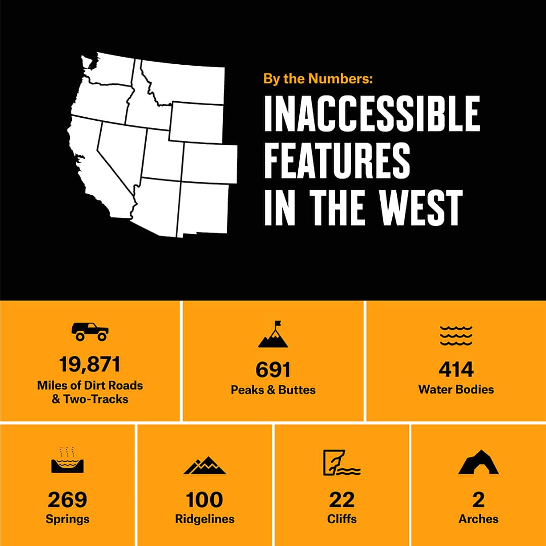
We also analyzed what exactly we’re missing on the 15 million acres of inaccessible land in the West, including hundreds of mountain peaks, water bodies, and geologic features. If these places weren’t landlocked, they would offer opportunities to hike, ski, fish, camp, swim, climb, backpack, and pursue or watch wildlife. And while there are many more millions of public land acres that are accessible, and many thousand more peaks, waterbodies, and geologic features the public can get to, the most accessible places are increasingly overcrowded. Not only does overcrowding negatively impact the flora and fauna and ecological processes of a place, it also negatively impacts our own health benefits of being in nature. This is why everyone who enjoys the outdoors, not just hunters, are impacted by landlocked public land.
What’s Next in 2022
This year, we will continue to provide funding to lands trusts, trail organizations, and others working to increase public access and lead stewardship efforts. We are well on our way to supporting 150,000 acres and 150 miles of trails, but we have a long way to go. In addition, expect to see more data analyses and new perspectives, as well as more new data on our maps. Get ready to be informed, inspired, and excited for your next adventure!
P.S. If you haven’t already read our Advocacy Philosophy, check it out here.