Pucker Ridge

Total Miles 17.6
Technical Rating
4 Moderate
Best Time Spring, Summer, Fall, Winter
Trail Type High-Clearance 4x4 Trail
Accessible By
Open Trail Map

Trail Overview

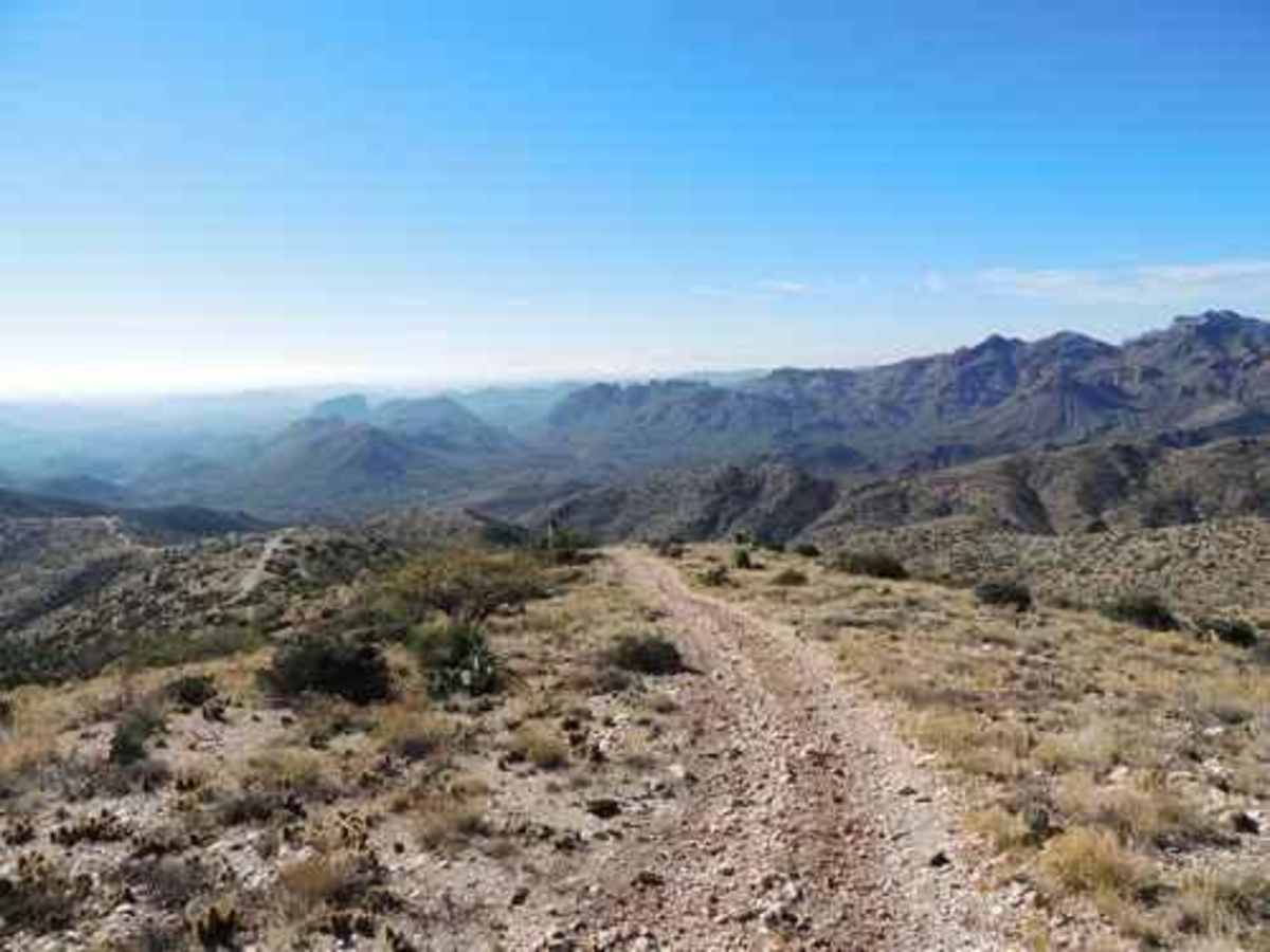
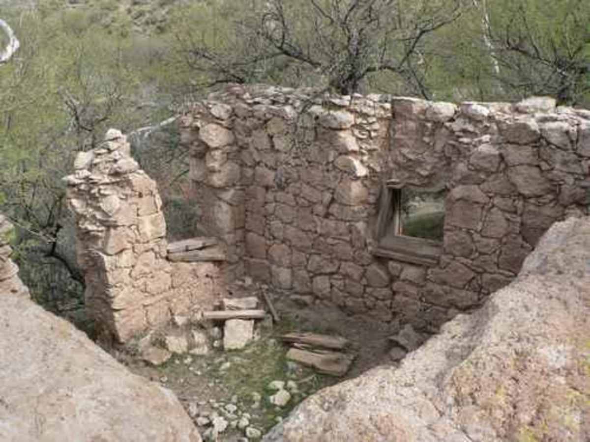
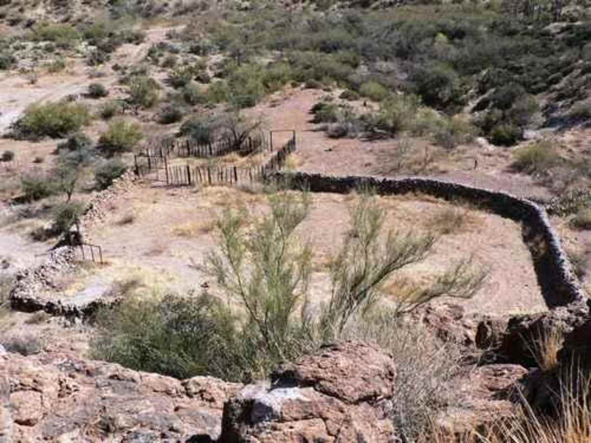
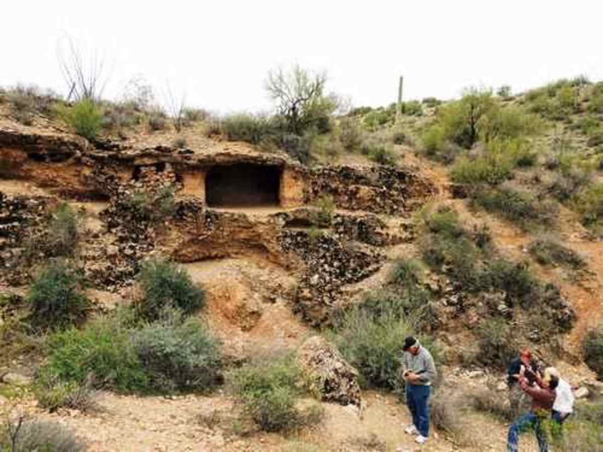
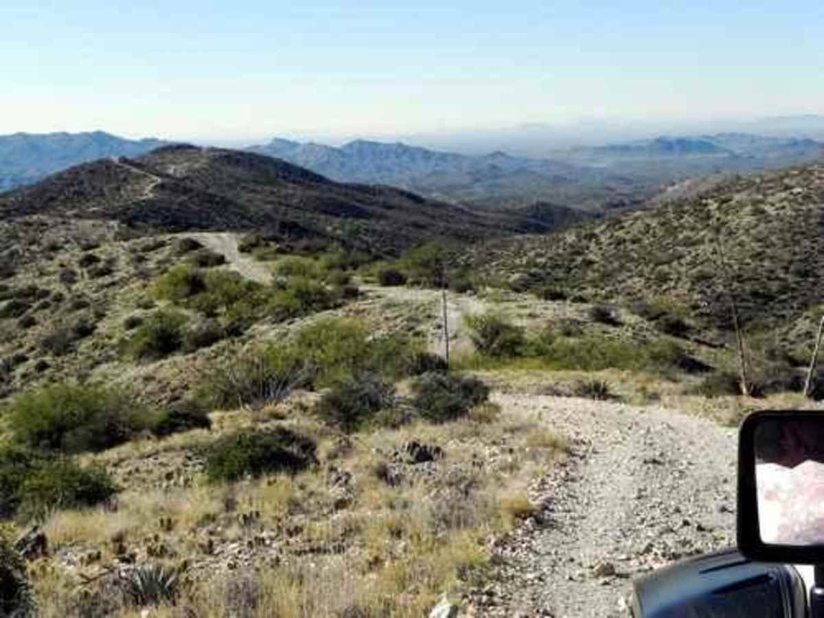
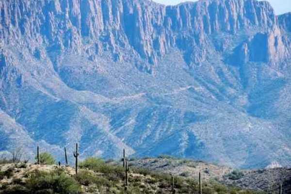
Pucker Ridge starts at 2,400' elevation and climbs ridgelines up to 4,600' elevation. It then drops back down another bunch of ridgelines to the beginning. There are some very unique attractions and great scenery along the way, including a Stone Corral, Indian Cave, Old Jail, and Mini Grand Canyon. It is a solid 4 rating and will offer challenges to novice drivers. The trail begins on US 60 near Boyce Thompson Arboretum, west of Superior, and is inside the Montana Mountain loop. The Mini Grand Canyon (right) is a slot canyon eroded through breccia. Breccia (BRET-cha) is a detrital sedimentary rock composed mostly of large, angular clasts. Breccia forms as streams transport grains, or clasts, only a short distance before depositing them within a stream channel or valley. Because of this short distance of transportation, the clasts have experienced relatively few collisions, and so still possess their original sharp edges and corners produced when they weathered from rocks in their source area. Breccia can also form from landslide masses that became fragmented as they moved downslope. Once such a mass stabilizes and solidifies, it can form a breccia containing huge, boulder-sized fragments. The matrix holding it together is fine sand or silt, cemented by secondary silica or calcite. This trail is easy enough to run in either direction, but we like to start with the walking attractions to get them out of the way early in the day while we are fresh. A counterclockwise loop. The stone corral must have taken quite a while to build, and there is a wing on it at least as big. The rocks stayed upright for many years as the concrete on top is new. The spur to this is on the left about a half mile before you turn off the Montana Mountain Loop. Old Jail? A friend showed me a 1994 photo of this structure showing bars in the windows. He had been told this was a jail, used as an overnight stop when transporting prisoners to the Territorial Prison in Yuma. This "cave" was described to me as possible Indian ruins. I doubt that is correct, but it is still very interesting. Contains a very small fireplace and chimney. After the Old Jail you will come to the Mini Grand Canyon. Be sure to start at the bottom end and walk up through it. Very unique for this area.A short distance after the Mini Grand Canyon you have a chance to hike to the Bat Cave. This will probably take an hour and involve a small bit of rock scrambling. Drive to the end of the road "Ridgeline Bat Cave" (included in the Minor Trails file) then hike down the small wash to a big wash. Hike down the big wash until you see the cave. Be aware that bat guano may contain spores of histoplasmosis, an infectious disease caught by inhaling the spores of the histoplasmosis capsulation fungus. Look that up if you are concerned. Now it is time to head for higher ground. The first significant climb is the namesake, Pucker Ridge. This will probably cause novice drivers to pucker a bit. Next, you will travel along ridgelines and climb toward a lunch spot at the high point of 4,600'.If you are feeling brave after lunch you can continue past the lunch spot and drop down a very steep hill called Disappearing Trail. Take a look to be sure you can make it back up before you start down. There is no other way out. What goes up must come down, so head home by dropping down the western leg and returning to where you started.

Photos of Pucker Ridge

Difficulty

Challenging obstacles for novice drivers with rock ledges and off camber

Technical Rating

4

Status Reports

Add Status Report
Tom Silva
Jun 12, 2026
Open
We went counter clock wise, stopped at the old site to educate the grandkid on a little AZ history. We saw one Jeep I stopped to talk they just kept going. Otherwise it was a nice drive minus the flat tire.
Fred Balzarini
Mar 06, 2026
Open
Randy Robichaud
Mar 04, 2026
Open
We were going counterclockwise, the trail was beautiful until we started the climb, and the road got rough. I know it's classified a four and I have Jeep 4 wheeled all over southwest Arizona and Utah. We have a lifted Jeep with 35" tires etc etc and my opinion is; not less than a 6 out of 10 rating. You are riding on the ridge with thousand foot drops either side on an arrow road and you're climbing up over Rock ledges at the same time. That is not a four in my opinion. Fantastic views though, great run just be prepared.
Jason Bingham
Jan 25, 2026
Open
Was hoping for a challenging trail with so many reports that this had gotten more difficult after the rains. It hasn’t. It’s much the same as it was a year ago. Still a 4 with optional obstacles that are MAYBE a 6. Great easy run with fun hiking and photo opportunities. We stopped and hiked several times, went near the bat cave, had lunch and still finished in under 4 hours. AZFrankenJeep Black Sheep Off-Road
Thomas Robinson
Jan 04, 2026
Open
Pucker ridge trail in turbo rzr 2 seat. DEFINITELY NOT A 4 I DON'T KNOW IF we went the back way but I was worried about my steering wheel pulling off before we made the top and was a bit shaky lol
Dennis Christensen
Dec 29, 2025
Open
I didn’t run this before the big rains in October to know if it has changed but the 4 it’s rated is way off compared to other OnX tracks I’ve done. I’d rate this a 6 or 7 with several deep wash outs and rock climbs. We finally got stopped at a steep rock climb that the Ranger Raptor wasn’t going up. It was also narrow and I got quite a bit of pin striping I didn’t expect. Would have been a really fun challenge in a SxS.
Thomas Mccormack
Dec 28, 2025
Open
We hit Montana mountain loop and decided to cut over to Pucker Ridge on our way back. This was one of the most fun trails I have hit in awhile. Very steep sections & a couple spots that will definitely make you pucker up 😂 it is definitely not a level 4 trail. I’d say it’s closer to a 7-8. Had a couple spots where it is very technical.
Bob Kadlec
Dec 22, 2025
Open
Bad wash outs one of our group tipped over so we turned around.
Jason Henley
Oct 17, 2025
Open
Ran a couple days after big storms. sections going up and down pretty eroded. ruts really deep and had to move a few blown down cacti from road.
Jaymz Robertson
Sep 20, 2025
Open
Got a late start and was slow going so crashed out in my Jeep at the lunch spot, then finished off for my birthday the next morning. Wasn't too bad, only one spot where I puckered up, but made it through. Went counterclockwise, rocky uphills, great views, but never found the cave or the jail.
Maia H
Apr 06, 2025
Open
Tried this trail clockwise and found the steeps just a little too steep for a novice like me. I made it up a few of the steeps until one really steep corner I saw a pair of sxs scramble up. Turned around then and found a nice lunch spot. Trail was a bit narrow for a Bronco but not too bad.
BH B
Dec 07, 2024
Open
Trail S 1000 with 28" tires, 62" wide. Riding counter clockwise, for our unit we rate this trail a strong 7 or an 8. At the top, look to the East to get a view of Superior in the distance. Pucker climbing section is a tight trail, some off camber ledges with a "Jesus Cliff" to infinity. Be alert for oncoming traffic because as you climb the Pucker, there is little to no space to pull over. Pucker Ridge is the perfect name for this trail and is not for the faint of heart if you dislike off camber cliffs with nothing to the side of the trail. Overall the trail was challenging, views were amazing, and the ride was awesome! We will for sure ride it again
mike k
Aug 30, 2024
Open
beautiful trail. stock 24 rubi with 33s, no issues. pulled the locker button a couple times and probably only needed the rear once or twice if that. great views, one of my favorites between queen valley and superior. recommend doing counter clockwise if you like rockier climbs rather then depending them. I'm slow going and like to stop, took me just under 5hrs leaving the 60 and getting back on the 60. max incline 23 degrees, max decline 23 degrees. max roll, that's up to you.
Garrick Olsen
Jun 15, 2024
Open
Did the loop counter-clockwise and saw one group near the start, otherwise it was empty. Trail was straightforward and easy to navigate. Great views! I don’t think I would attempt without 4wd but most stock high clearance vehicles should be fine. I drove it in a JLU Rubicon with 35s and was fine.
R Judd
May 09, 2024
Open

Pucker Ridge Trail can be accessed by the following ride types:

  • Single Track
  • 50 Inch
  • 60 Inch
  • High Clearance

Pucker Ridge Map

The onX Offroad Difference

onX Offroad combines trail photos, descriptions, difficulty ratings, width restrictions, seasonality, and more in a user-friendly interface. Available on all devices, with offline access and full compatibility with CarPlay and Android Auto. Discover what you're missing today!

Open Trail Map