
Beginner Off-Road Trails
Near West Branch, Michigan
Explore All Beginner Trails Near West Branch, Michigan
Beginner Off-Road Trails Near West Branch, Michigan
Discover the best beginner-friendly off-road trails near you. These easier, lower-rated trails are a great place to start — browse trail maps, check difficulty ratings, and find your next adventure.
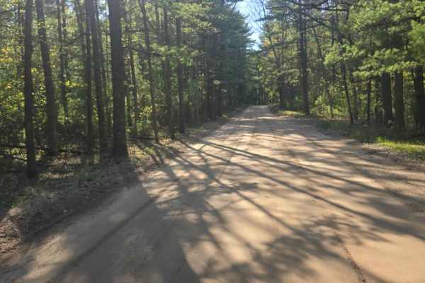
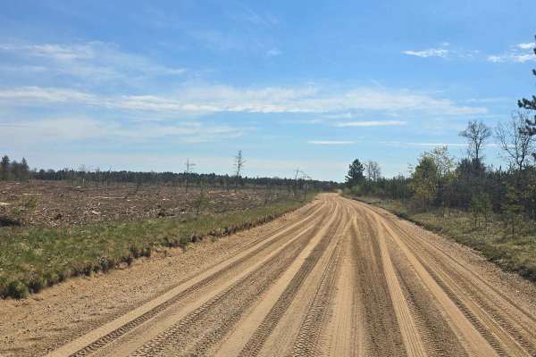
Dow Road
Dow Road is a 2-ish vehicle-wide hard-packed road that will take you through older forest. This trail will take you to the West Branch area or the Clear Lake area for food and fuel. Plenty of other trails branch off this trail for more areas to explore the area. This road is a winding road that is a...
Learn more about Dow Road
Aginaw Loop
Aginaw Loop to Knoch is part of multiple trail systems in the area of the checkerboard. This trail is made up of pines and hardwood and starts as double-lane dirt and then drops to single-lane dirt. If you're looking for a nice ride, this is the trail for you. The trail does cross the Ogemaw Hills O...
Learn more about Aginaw Loop
Hippie Circle Trail
This challenging two-track begins with a short stretch of soft sand before quickly transitioning to hard-packed sandy terrain. From there, the trail takes on a rollercoaster-like character, over a series of steep hills, sharp descents, and constant elevation changes. The route becomes increasingly r...
Learn more about Hippie Circle Trail
West Boehm Road
This seasonal road begins at the end of Boehm Road. The road is wide at the entrance, but it does become narrower or less travelled on the north and west sides of the loop. The east side of the trail runs along an easement for power lines. There is not much elevation change on the trail, and it does...
Learn more about West Boehm Road
Lentz Trail
This trail runs from north to south. At the south end, it starts off Sage Lake Road and dead ends right before Rose City Road. While traveling the trail, the width alternates between one and two vehicles wide. The trail is a mix of loose sand and hard pack while traveling through older forest and cl...
Learn more about Lentz Trail
Spencers Trail
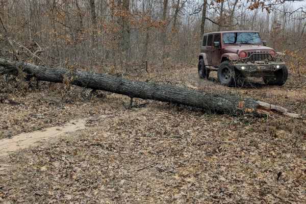
This trail is typical of the Michigan two-track style trail. Sandy with little elevation change. It begins at the end of a dirt road and goes all the way back to a creek. Spencer's Trail intersects with a couple of other trails. There is a large tree down on the trail just past the intersection, lim...
Learn more about Spencers Trail
South Eddy Creek Trail
This Trail is a typical Michigan two-track. Dirt track, wide enough for one vehicle. The trail does not lead to any other trails, but there are quite a few grassy spots to pull off for dispersed camping. The west side of the loop portion is definitely a much tighter, less-traveled trail. The south s...
Learn more about South Eddy Creek Trail
Emerson Trail
This trail runs from Spenser Trail to South Morrison Road. The east side of the trail, once crossed over the creek, becomes very tight and banked, weaving back and forth through the trees. It was a fun trail to drive, but it definitely needs some trimming for full-size vehicles.
Learn more about Emerson Trail
Beaver Lake Trail
Beaver Lake Trail is a 3 or so vehicle-wide sandy trail that will take you through new growth forest, older forest, and recently clear-cut areas. This trail will take you to the St. Helen area or the Clear Lake area for food and fuel. Plenty of other trails branch off this trail for more areas to ex...
Learn more about Beaver Lake Trail
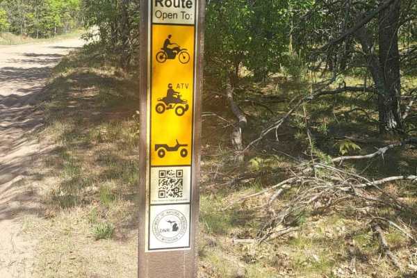
Ogemaw Hills ORV Route
This Michigan DNR ORV Route is open to full-size, 50-inch, and motorcycles with ORV permits and trail permit stickers. This area connects with St. Helen ORV Route on the west side. The west side of this trail is very wide and deep sand with possible water crossings. The east side is a narrow two-tra...
Learn more about Ogemaw Hills ORV Route
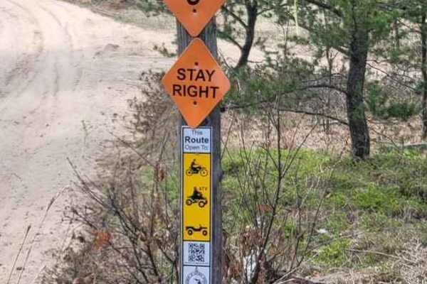
St. Helen ORV Route - West
Michigan DNR ORV Route is open to full-size vehicles, 50 inch, and 24 inch with ORV and trail permits. The route is mostly soft sand. This section of the route is a connector between St. Helen Route and Denton Hills Route. It's mostly very wide and flat. The trail becomes washboard quickly with the ...
Learn more about St. Helen ORV Route - West
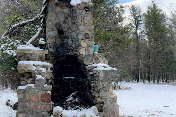
Sacred Chimney Trail
This trail is a point-to-point section of DNR Trail 6, which is part of extensive off-road vehicle trails that branch out from the ORV-friendly community of St. Helen, Michigan. This short but popular section of trail begins at a large parking lot, maintained by the Roscommon State Forest Area, near...
Learn more about Sacred Chimney Trail
Hilly Trail
Hilly adventure awaits on this unmapped trail in the Roscommon Forest. This trail is South off of Sandy Trail, and is just West of the St. Helen's South ORV Route. There is a loop off of this trail midway South. This trail is one lane and is sand and dirt. Trees hang over the trail, creating a canop...
Learn more about Hilly Trail
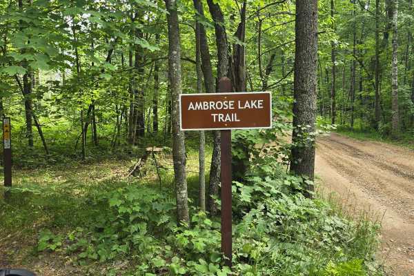
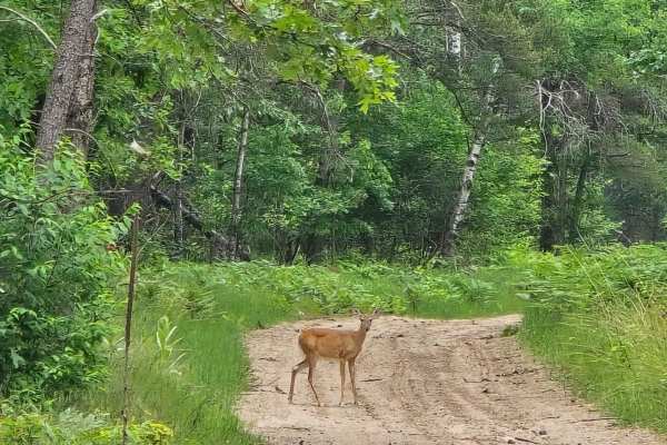
Ambrose Lake Trail East Loop
This 50" trail is a loop leaving from Ambrose Lake trailhead. You will find hard-packed and soft sand with some decent elevation changes, mature trees, and recent clear-cut areas. While running this trail you will see all sorts of wildlife. This trail is also part of the MCCCT.
Learn more about Ambrose Lake Trail East Loop
Piper Lake Rd
This route runs through mature woods and recent clear-cut areas. The route runs from the Ambrose Lake area to the south along the YMCA camp. The route has everything from hard pack to mud holes to soft sand. Other trails connect to this route along the way.
Learn more about Piper Lake Rd
Ambrose Lake to Rose City Trail
The Ambrose Lake to Rose City Trail is a moderate ORV trail that provides a direct, off-road connection between the Ambrose Lake area and the city of Rose City in Roscommon County. It’s designed for riders who want a true trail experience rather than road-based travel, with terrain that reflects cla...
Learn more about Ambrose Lake to Rose City Trail
Ambrose Lake Trail West Loop
This 50" trail is a loop leaving from Ambrose Lake trailhead. You will find hard-packed and soft sand with some decent elevation changes, mature trees, and recent clear-cut areas. While running this trail you will see all sorts of wildlife. This trail is also part of the MCCCT.
Learn more about Ambrose Lake Trail West Loop
Hougton Creek Trail
This trail runs east to west, at the west end of the trail is Ambrose Lake State Campground, along with the Ambrose Lake ORV trailhead. The east end of the trail runs dead-end into another trail. The trail is mostly loose sand with a few hill climbs. The trail can become rough at times due to the mi...
Learn more about Hougton Creek Trail
St. Helen Trail
St Helen Trail is a 3ish-wide vehicle sandy trail that will take you through new growth forest and older forest. This trail will take you to the St. Helen area or the West Branch area for food and fuel. Plenty of other trails branch off this trail for more areas to explore the area. Also, there is a...
Learn more about St. Helen Trail

Rose City Lookout
Sand trails, mild hill climbs, and great views; what more could you ask for? This route will take you through an area that is a little overgrown and could use trimming, but if you don't mind that good ol' Michigan pinstriping, then you'll be fine. There are a few hill climbs and a rewarding lookout ...
Learn more about Rose City Lookout
Beginner ATV trails near West Branch, Michigan
Explore ATV-friendly trails near you. These trails are accessible for vehicles up to 50 inches wide, perfect for ATVs and smaller off-road machines.
Dow Road
Dow Road is a 2-ish vehicle-wide hard-packed road that will take you through older forest. This trail will take you to the West Branch area or the Clear Lake area for food and fuel. Plenty of other trails branch off this trail for more areas to explore the area. This road is a winding road that is a...
Learn more about Dow Road
Aginaw Loop
Aginaw Loop to Knoch is part of multiple trail systems in the area of the checkerboard. This trail is made up of pines and hardwood and starts as double-lane dirt and then drops to single-lane dirt. If you're looking for a nice ride, this is the trail for you. The trail does cross the Ogemaw Hills O...
Learn more about Aginaw Loop
Hippie Circle Trail
This challenging two-track begins with a short stretch of soft sand before quickly transitioning to hard-packed sandy terrain. From there, the trail takes on a rollercoaster-like character, over a series of steep hills, sharp descents, and constant elevation changes. The route becomes increasingly r...
Learn more about Hippie Circle Trail
Lentz Trail
This trail runs from north to south. At the south end, it starts off Sage Lake Road and dead ends right before Rose City Road. While traveling the trail, the width alternates between one and two vehicles wide. The trail is a mix of loose sand and hard pack while traveling through older forest and cl...
Learn more about Lentz Trail
Beginner UTV/side-by-side trails near West Branch, Michigan
Find UTV and side-by-side trails near you. These trails accommodate vehicles up to 60 inches wide, ideal for UTVs, side-by-sides, and wider off-road rigs.
Dow Road
Dow Road is a 2-ish vehicle-wide hard-packed road that will take you through older forest. This trail will take you to the West Branch area or the Clear Lake area for food and fuel. Plenty of other trails branch off this trail for more areas to explore the area. This road is a winding road that is a...
Learn more about Dow Road
Aginaw Loop
Aginaw Loop to Knoch is part of multiple trail systems in the area of the checkerboard. This trail is made up of pines and hardwood and starts as double-lane dirt and then drops to single-lane dirt. If you're looking for a nice ride, this is the trail for you. The trail does cross the Ogemaw Hills O...
Learn more about Aginaw Loop
Hippie Circle Trail
This challenging two-track begins with a short stretch of soft sand before quickly transitioning to hard-packed sandy terrain. From there, the trail takes on a rollercoaster-like character, over a series of steep hills, sharp descents, and constant elevation changes. The route becomes increasingly r...
Learn more about Hippie Circle Trail
Lentz Trail
This trail runs from north to south. At the south end, it starts off Sage Lake Road and dead ends right before Rose City Road. While traveling the trail, the width alternates between one and two vehicles wide. The trail is a mix of loose sand and hard pack while traveling through older forest and cl...
Learn more about Lentz Trail
The onX Offroad Difference
onX Offroad combines trail photos, descriptions, difficulty ratings, width restrictions, seasonality, and more in a user-friendly interface. Available on all devices, with offline access and full compatibility with CarPlay and Android Auto. Discover what you're missing today!
Open Trail Map