
Beginner Off-Road Trails
Near Staves, Arkansas
Explore All Beginner Trails Near Staves, Arkansas
Beginner Off-Road Trails Near Staves, Arkansas
Discover the best beginner-friendly off-road trails near you. These easier, lower-rated trails are a great place to start — browse trail maps, check difficulty ratings, and find your next adventure.
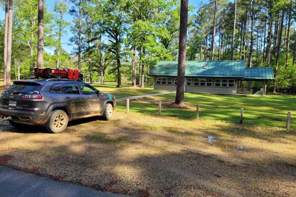
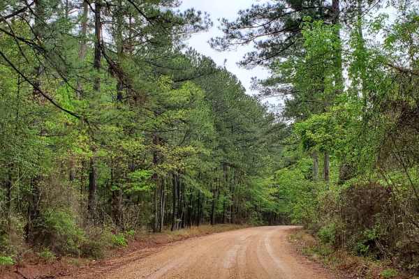
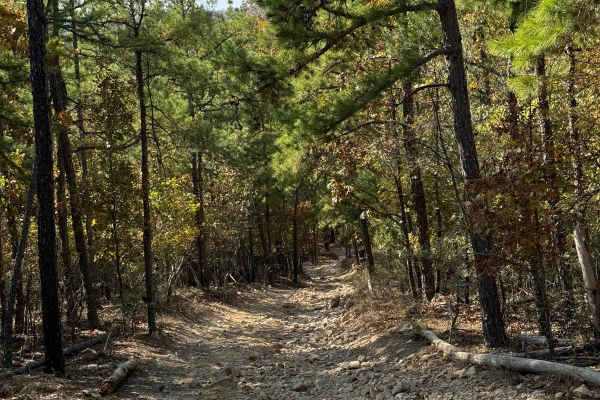
The Arkansas Overland Route - Section 13 - Moro State Park
Gravel road that can be nasty when wet. This section has some pavement that takes you into Moro State Park. This is the beginning of The Trailhawk Loop. The Trail Hawk Loop is part of The Arkansas Overland Route. This is a good area to camp and refresh before starting the TrailHawk Loop.
Learn more about The Arkansas Overland Route - Section 13 - Moro State Park
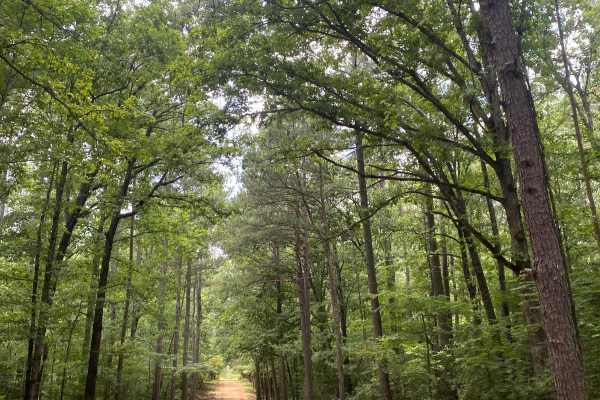
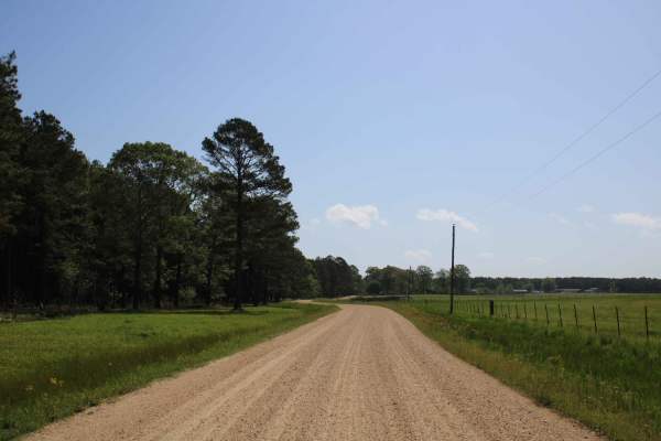
Potlach Road
This is a well-maintained dirt road with a few campsites along the way. This road leads through the Moro Big Pine WMA and there are several horseshoe lakes in the surrounding areas. It is very common to see wildlife such as hogs, turkeys, deer, and occasionally bears. This road can be very dusty dur...
Learn more about Potlach Road
The Arkansas Overland Route - TrailHawk Loop - Section 15
Gravel and dirt roads that can be muddy and slick with possible ruts when wet. This is Section 15 of the Arkansas Overland Route. This section makes up the Hawks' beak when looking at this loop on the map. There are some nice straight sections on this trail. Watch for wildlife. This road goes to the...
Learn more about The Arkansas Overland Route - TrailHawk Loop - Section 15
Champagnolle Creek Loop
The Champagnolle Creek Loop is a well-maintained dirt road with some uneven and rutted sections. While the road is easily passable during normal weather, the high river level makes the road impassable at times. Along this route, expect mild traffic, especially during prime fishing and hunting season...
Learn more about Champagnolle Creek Loop
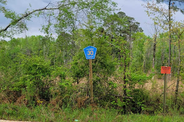
The Arkansas Overland Route - Section 11 - County Road 30 and 32
This is Section 11 of The Arkansas Overland Route. This section is gravel and dirt roads and ends at a deer camp. The road continues on, but after rain, it is all mud and a narrow track. After and during rains, these roads can be messy and have water across them. Some washed-out holes can be deep, s...
Learn more about The Arkansas Overland Route - Section 11 - County Road 30 and 32
The Arkansas Overland Route - Section 5 - Highway 76 to Highway 278
This trail is a mix of dirt, gravel, and asphalt. This area has some beautiful views and creeks. This is the 5th section of the Arkansas Overlanding Route that starts off HWY 82 (FALCON Bottoms Back Roads) trail. This section can be slick and muddy in sections when wet. Paved sections can be rough i...
Learn more about The Arkansas Overland Route - Section 5 - Highway 76 to Highway 278
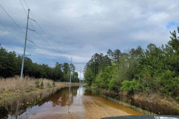
The Arkansas Overland Route - Section 12 - Dead End but Fresh Beginning
This is Section 12 of The Arkansas Overland Route. Deep graveled roads with potholes and water crossing after rain. Ending at HWY 160, a right turn will take you towards Moro State Park. There are dispersed camping areas along this trail, some big enough for group camping.
Learn more about The Arkansas Overland Route - Section 12 - Dead End but Fresh Beginning
The Arkansas Overland Route - TrailHawk Loop - Section 16
Gravel and pavement roads that go to Eagle Landing Lake and boat ramp. Portions of roads can be muddy and slick when wet. These roads are well maintained but can be a bit rough in areas. There is dispersed camping and picnicking at the Eagle Landing Lake area.
Learn more about The Arkansas Overland Route - TrailHawk Loop - Section 16
The Arkansas Overland Route - Section 9 - Norphlet Trek
Section 9 of The Arkansas Overland Route contains a mix of pavement, gravel, and dirt. Great views with a mix of Arkansas backroads. This section can have slick and muddy areas. Some areas can flood during heavy rains. This section ends at Norphlet and leads to many more. This is a quaint little tow...
Learn more about The Arkansas Overland Route - Section 9 - Norphlet Trek
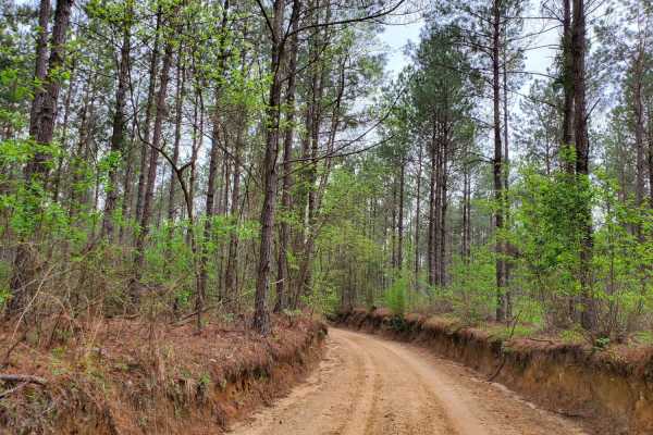
The Arkansas Overland Route - TrailHawk Loop - Section 14 - The Beginning
These are gravel roads that are dusty when dry and can be nasty when wet. They seem well maintained, and there is awesome scenery. Watch for farm equipment on the roads and cattle. This is the first section of The TrailHawk Loop, Section 14 of The Arkansas Overland Route. This section starts the hea...
Learn more about The Arkansas Overland Route - TrailHawk Loop - Section 14 - The Beginning
E20 Road to Prothane
E20 Road to Prothane is an easy trail through the woods, primarily used by those finishing D1 Rubicon Ridge as a direct route to the overlook at Prothane Point. It is mostly dirt with a few small rocks. The park rating for this trail is 2 diamonds.
A Park Day-Use Trail Pass is required to access th...
Learn more about E20 Road to Prothane
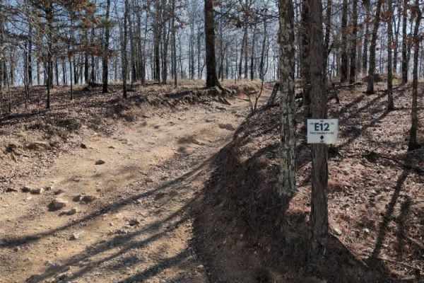
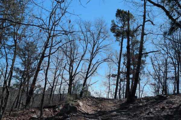
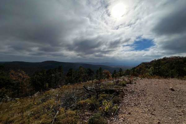
E12 Prothane Point
E12 Prothane Point is an easy trail through the woods that takes you to a scenic overlook. It provides a nice scenic exit from D1 Rubicon Ridge. It is a great place to stop for lunch and enjoy the view.
The park rating for this trail is 1 diamond. A Park Day-Use Trail Pass is required to access thi...
Learn more about E12 Prothane Point
AR 2 - Main Park Road
This is the easy shortcut between the eastern side of the park and the main park entrance. It is a fairly easy trail but has a few washouts and off-camber sections. If you completed Rubicon Ridge D1, one of four Jeep Badge of Honor trails, this provides a quick and easy way to return to the park ent...
Learn more about AR 2 - Main Park Road
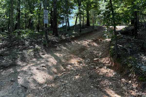
F6 Snake Early Exit
This is the early exit of the Badge of Honor trail F19-Snake. This early exit is a steep climb up onto highway two which you can then go onto highway five by turning left or back down to the main office by turning right from the exit. It is an extremely small passthrough.
Learn more about F6 Snake Early Exit
F20 Exit Trail
Once you are done with either the Ravine or Gorge this trail will be the way to get back to the Lake Winder trail which you can use to access other trails. The trail is fairly easy with loose rock and a slow decline. Just don't be too heavy on the brakes and let the engine do the work.
Learn more about F20 Exit Trail
AR 5 - Main Park Road
This is the main road that runs along the top ride of the east side of the park. Many of the trails start and begin off this road. Many of the advanced park trails are directional, so be mindful of that when navigating from one trail to the next. This road is rough in some areas but most vehicles at...
Learn more about AR 5 - Main Park Road
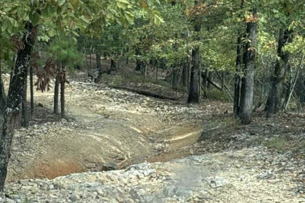
F41 Compass Canyon
This trail provides a fairly easy connection between the east and west sides of the park. It is one vehicle wide with plenty of places to pass since it is two-way traffic. On its eastern end it connects to AR Highway 5 trail and the western end connects to Lash's Loop F17 near the intersection with...
Learn more about F41 Compass Canyon
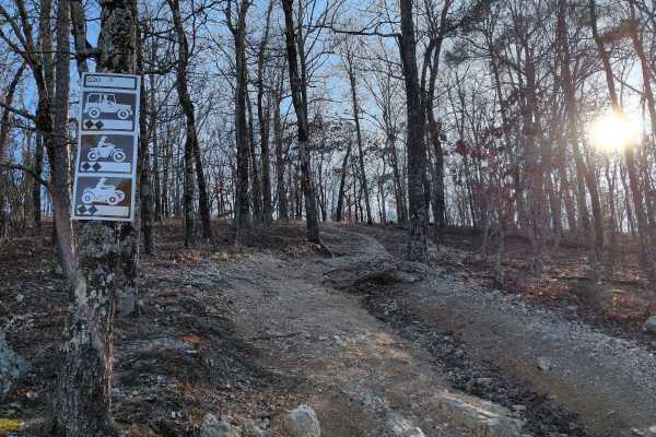
G20
G20 is a shortcut trail that branches off of G6 Squid's Jaunt and goes up into the woods near the end of F52 Head Banger and the beginning of F57. It is a little steep at the beginning, but the trail is pretty smooth overall.
The park rating for this trail is 2 diamonds. A Park Day-Use Trail Pass i...
Learn more about G20
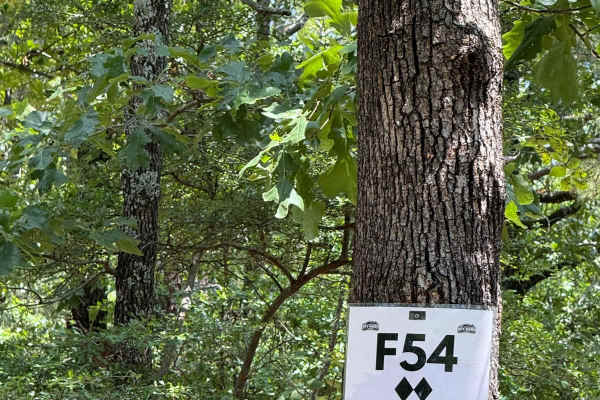
F54
F54 Village Roll is a connecting trail between F50 and F41. Coming from the F50 side you will be met with a climb up the hill and cross paths with F57. There are some larger rocks on this crossing, and depending on trail conditions could be pretty rough. You will end out on F41 near the "Village Ove...
Learn more about F54
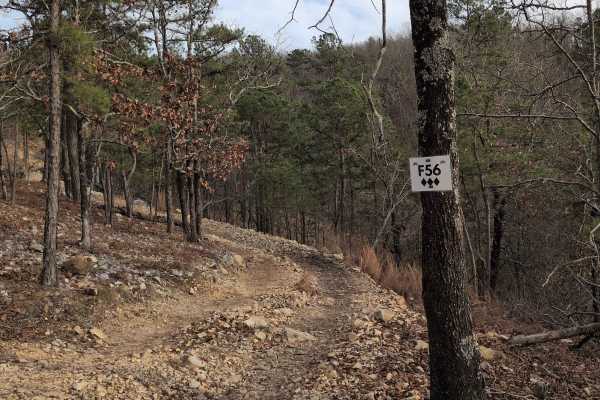
F56
F56 is just a short trail connecting F50 to F54. It is mostly loose rock with a nice view of F52 Head Banger down below. It is somewhat narrow and near a steep drop-off, so ride with caution.
The park rating for this trail is 3 diamonds. A Park Day-Use Trail Pass is required to access this system o...
Learn more about F56
Beginner ATV trails near Staves, Arkansas
Explore ATV-friendly trails near you. These trails are accessible for vehicles up to 50 inches wide, perfect for ATVs and smaller off-road machines.
Potlach Road
This is a well-maintained dirt road with a few campsites along the way. This road leads through the Moro Big Pine WMA and there are several horseshoe lakes in the surrounding areas. It is very common to see wildlife such as hogs, turkeys, deer, and occasionally bears. This road can be very dusty dur...
Learn more about Potlach Road
Champagnolle Creek Loop
The Champagnolle Creek Loop is a well-maintained dirt road with some uneven and rutted sections. While the road is easily passable during normal weather, the high river level makes the road impassable at times. Along this route, expect mild traffic, especially during prime fishing and hunting season...
Learn more about Champagnolle Creek Loop
E20 Road to Prothane
E20 Road to Prothane is an easy trail through the woods, primarily used by those finishing D1 Rubicon Ridge as a direct route to the overlook at Prothane Point. It is mostly dirt with a few small rocks. The park rating for this trail is 2 diamonds.
A Park Day-Use Trail Pass is required to access th...
Learn more about E20 Road to Prothane
E12 Prothane Point
E12 Prothane Point is an easy trail through the woods that takes you to a scenic overlook. It provides a nice scenic exit from D1 Rubicon Ridge. It is a great place to stop for lunch and enjoy the view.
The park rating for this trail is 1 diamond. A Park Day-Use Trail Pass is required to access thi...
Learn more about E12 Prothane Point
Beginner UTV/side-by-side trails near Staves, Arkansas
Find UTV and side-by-side trails near you. These trails accommodate vehicles up to 60 inches wide, ideal for UTVs, side-by-sides, and wider off-road rigs.
Potlach Road
This is a well-maintained dirt road with a few campsites along the way. This road leads through the Moro Big Pine WMA and there are several horseshoe lakes in the surrounding areas. It is very common to see wildlife such as hogs, turkeys, deer, and occasionally bears. This road can be very dusty dur...
Learn more about Potlach Road
Champagnolle Creek Loop
The Champagnolle Creek Loop is a well-maintained dirt road with some uneven and rutted sections. While the road is easily passable during normal weather, the high river level makes the road impassable at times. Along this route, expect mild traffic, especially during prime fishing and hunting season...
Learn more about Champagnolle Creek Loop
E20 Road to Prothane
E20 Road to Prothane is an easy trail through the woods, primarily used by those finishing D1 Rubicon Ridge as a direct route to the overlook at Prothane Point. It is mostly dirt with a few small rocks. The park rating for this trail is 2 diamonds.
A Park Day-Use Trail Pass is required to access th...
Learn more about E20 Road to Prothane
E12 Prothane Point
E12 Prothane Point is an easy trail through the woods that takes you to a scenic overlook. It provides a nice scenic exit from D1 Rubicon Ridge. It is a great place to stop for lunch and enjoy the view.
The park rating for this trail is 1 diamond. A Park Day-Use Trail Pass is required to access thi...
Learn more about E12 Prothane Point
The onX Offroad Difference
onX Offroad combines trail photos, descriptions, difficulty ratings, width restrictions, seasonality, and more in a user-friendly interface. Available on all devices, with offline access and full compatibility with CarPlay and Android Auto. Discover what you're missing today!
Open Trail Map