

Ready to explore this trail?
View Trail Map in AppRegional Classic
A must do route for the area handpicked by local experts.
The trail names for the Browns Creek Trail #1429 and Wagon Loop Trail #1427 were switched several years ago to reduce confusion. However, that means that older maps and some online resources don't align with the trail signs. If in doubt, refer to the route shown here.
Path Type
There and Back
The Browns Lake hike begins from a well-developed trailhead equipped with a pit toilet and a large parking area. On weekends—especially during the spring and summer—the parking lot can fill up quickly. The route starts on the Browns Creek Trail (#1429), which begins directly to the right of the pit toilet. Note that the trail names for Browns Creek Trail #1429 and Wagon Loop Trail #1427 were switched several years ago to reduce confusion, meaning older maps might not align with current trail signs.
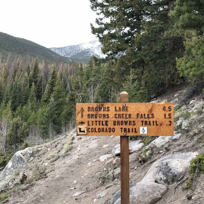
The initial climb along the Browns Creek Trail is steep and rocky, quickly gaining elevation while providing picturesque views over the Arkansas Valley below. This trail is heavily used by equestrians and is also open to mountain bikers, so stay alert for other users. At the junction with the Colorado Trail, continue up and to the left for a short distance before turning right on the signed Browns Creek Trail to continue heading uphill.
After hiking through an open meadow with spectacular views of Mount White to the left and Mount Antero to the right, the trail snakes through the trees and over a couple of bridges. Keep an eye out for a sign pointing left toward Browns Creek Falls via a short spur trail. After visiting the waterfall, return to the main trail and turn left to continue up toward Browns Lake.
From the waterfall junction, the hike gets substantially more difficult as the trail grows steeper, narrower, and rougher. The tread consists primarily of large boulders with loose, rolling rocks in between. Your ultimate reward is reaching beautiful Browns Lake, which is nestled right at treeline below Mount White and Tabeguache Peak at roughly 11,300 feet. The lake serves as the turnaround point for day hikers, while overnight backpackers should camp well away from the water's edge and follow Leave No Trace principles.
According to a report on Hiking Project, "In 2019, a microburst flooded the valley, and the beaver dam burst. Brown's Lake is now just Brown's Creek. What had been a shallow but beautiful lake is gone. We will see if the beavers choose to rebuild." However, recent reports indicate that the beavers have rebuilt the dam and that the lake is full.
No Condition Reports
Browns Creek Falls
Browns Creek Falls
Mount Antero via Little Browns Creek
Mount Antero via Little Browns Creek
Colorado Trail: Segment 14
Colorado Trail: Segment 14
Mount Princeton
Mount Princeton
Agnes Vaille Falls
Agnes Vaille Falls
Mount Shavano East Slopes
Mount Shavano East Slopes
Contributors

