
Dirt Bike Trails
Near Panther Burn, Mississippi
Explore All Dirt Bike Trails Near Panther Burn, Mississippi
Dirt Bike Trails Near Panther Burn, Mississippi
Discover the best dirt bike trails near you. Browse trail maps, check difficulty ratings, and find your next adventure — whether you're looking for a quick ride or an all-day expedition.
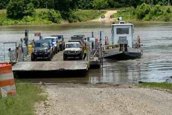
Kings Point Island
You can only reach Kings Point Island via Ferry. Begin your trip on Kings Point Ferry Road, which at the beginning consists of both gravel and asphalt, but don't let the asphalt fool you, it's just as bumpy as the gravel road. The trip to the ferry is 9 miles. You will pass many fields of soybeans, ...
Learn more about Kings Point Island

The Arkansas Overland Route - TrailHawk Loop - Section 16
Gravel and pavement roads that go to Eagle Landing Lake and boat ramp. Portions of roads can be muddy and slick when wet. These roads are well maintained but can be a bit rough in areas. There is dispersed camping and picnicking at the Eagle Landing Lake area.
Learn more about The Arkansas Overland Route - TrailHawk Loop - Section 16

The Arkansas Overland Route - TrailHawk Loop - Section 15
Gravel and dirt roads that can be muddy and slick with possible ruts when wet. This is Section 15 of the Arkansas Overland Route. This section makes up the Hawks' beak when looking at this loop on the map. There are some nice straight sections on this trail. Watch for wildlife. This road goes to the...
Learn more about The Arkansas Overland Route - TrailHawk Loop - Section 15

Beinville NF (Lena to Laurel)
This trail is in the Beinville National Forest and it's all hard packed gravel from Hillsboro Ludlow Road to Highway 13 just North of Morton city limits. It has tons of turns that you can make to further your adventure, you can make loops back to the main trail. Be careful getting off of the main tr...
Learn more about Beinville NF (Lena to Laurel)

NF550
As you enter this trailhead you'll be on hard packed gravel that slowly turns into washouts, so keep a slower pace. As you advance down the trail you'll notice that the woods turn to cutover, soon after that you'll find some deep ruts that are extremely muddy when wet. The majority of this trail is ...
Learn more about NF550

Potlach Road
This is a well-maintained dirt road with a few campsites along the way. This road leads through the Moro Big Pine WMA and there are several horseshoe lakes in the surrounding areas. It is very common to see wildlife such as hogs, turkeys, deer, and occasionally bears. This road can be very dusty dur...
Learn more about Potlach Road

Champagnolle Creek Loop
The Champagnolle Creek Loop is a well-maintained dirt road with some uneven and rutted sections. While the road is easily passable during normal weather, the high river level makes the road impassable at times. Along this route, expect mild traffic, especially during prime fishing and hunting season...
Learn more about Champagnolle Creek Loop

Rolling Rocks
Start in East Creek bottom and begin the climb from one of two entrances that are approximately twenty feet apart. This trail is pure rocks. It has multiple lines up and multiple exits. This trail will challenge mildly built rigs all the way to rockbouncers. This is one of the most used trails in th...
Learn more about Rolling Rocks

Mountain Road
Start out in a creek bottom and drive up a very rocky climb. There are two large rock ledges. One has a bypass, the other does not. If it is wet, this trail will become very slick. You will exit into a field at the top of the park.
Learn more about Mountain Road

Bottom Road
This route starts off the main road through the park. There is a small sand dune at the beginning of the trail to the right. You enter into the woods from a small field. If it is wet, you will pass through several small mud holes and several larger mud holes along the way. When you get to the end, y...
Learn more about Bottom Road

East Creek
This is a beautiful rock and dirt trail through a valley. You don't even realize you are in Louisiana with all the rocks. It begins with a steep descent into the valley down a mostly dirt trail and some steep rock ledges at the top. You drop down into a lush green forest with rocks following a path ...
Learn more about East Creek

West Creek
This is a pretty moderate trail that goes down into the valley. It begins with a steep descent to a dirt path that is very slick when it is wet. Near the bottom of the descent is a deep washout that can be tricky to navigate into. After this first obstacle, most of the trail is a winding path throug...
Learn more about West Creek

Stone Hindge
Enter from West Creek Bottom and enter into a large washout. There is a large boulder in the middle of the trail at the bottom. After clearing this, you will be on a tight trail with massive boulders on the edges of the trail. There is a tree that will take out a windshield and top if not careful. A...
Learn more about Stone Hindge
ATV trails near Panther Burn, Mississippi
Explore ATV-friendly trails near you. These trails are accessible for vehicles up to 50 inches wide, perfect for ATVs and smaller off-road machines.

Beinville NF (Lena to Laurel)
This trail is in the Beinville National Forest and it's all hard packed gravel from Hillsboro Ludlow Road to Highway 13 just North of Morton city limits. It has tons of turns that you can make to further your adventure, you can make loops back to the main trail. Be careful getting off of the main tr...
Learn more about Beinville NF (Lena to Laurel)

NF550
As you enter this trailhead you'll be on hard packed gravel that slowly turns into washouts, so keep a slower pace. As you advance down the trail you'll notice that the woods turn to cutover, soon after that you'll find some deep ruts that are extremely muddy when wet. The majority of this trail is ...
Learn more about NF550

Potlach Road
This is a well-maintained dirt road with a few campsites along the way. This road leads through the Moro Big Pine WMA and there are several horseshoe lakes in the surrounding areas. It is very common to see wildlife such as hogs, turkeys, deer, and occasionally bears. This road can be very dusty dur...
Learn more about Potlach Road

Champagnolle Creek Loop
The Champagnolle Creek Loop is a well-maintained dirt road with some uneven and rutted sections. While the road is easily passable during normal weather, the high river level makes the road impassable at times. Along this route, expect mild traffic, especially during prime fishing and hunting season...
Learn more about Champagnolle Creek Loop
UTV/side-by-side trails near Panther Burn, Mississippi
Find UTV and side-by-side trails near you. These trails accommodate vehicles up to 60 inches wide, ideal for UTVs, side-by-sides, and wider off-road rigs.

Beinville NF (Lena to Laurel)
This trail is in the Beinville National Forest and it's all hard packed gravel from Hillsboro Ludlow Road to Highway 13 just North of Morton city limits. It has tons of turns that you can make to further your adventure, you can make loops back to the main trail. Be careful getting off of the main tr...
Learn more about Beinville NF (Lena to Laurel)

NF550
As you enter this trailhead you'll be on hard packed gravel that slowly turns into washouts, so keep a slower pace. As you advance down the trail you'll notice that the woods turn to cutover, soon after that you'll find some deep ruts that are extremely muddy when wet. The majority of this trail is ...
Learn more about NF550

Potlach Road
This is a well-maintained dirt road with a few campsites along the way. This road leads through the Moro Big Pine WMA and there are several horseshoe lakes in the surrounding areas. It is very common to see wildlife such as hogs, turkeys, deer, and occasionally bears. This road can be very dusty dur...
Learn more about Potlach Road

Champagnolle Creek Loop
The Champagnolle Creek Loop is a well-maintained dirt road with some uneven and rutted sections. While the road is easily passable during normal weather, the high river level makes the road impassable at times. Along this route, expect mild traffic, especially during prime fishing and hunting season...
Learn more about Champagnolle Creek Loop
The onX Offroad Difference
onX Offroad combines trail photos, descriptions, difficulty ratings, width restrictions, seasonality, and more in a user-friendly interface. Available on all devices, with offline access and full compatibility with CarPlay and Android Auto. Discover what you're missing today!
Open Trail Map