
Beginner Off-Road Trails
Near West Union, Iowa
Explore All Beginner Trails Near West Union, Iowa
Beginner Off-Road Trails Near West Union, Iowa
Discover the best beginner-friendly off-road trails near you. These easier, lower-rated trails are a great place to start — browse trail maps, check difficulty ratings, and find your next adventure.
Big Springs Old Log Road
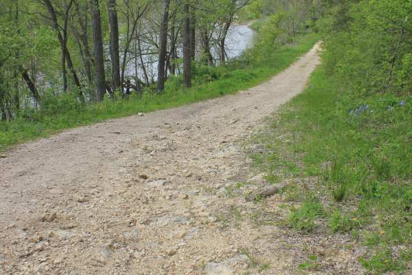
This Turkey River backcountry trail is one of those hidden Iowa routes that most people would never notice unless someone local pointed them toward it. Used mainly by farmers, hunters during the fall season, and those looking for a quiet way to access the river, this Class 8 road offers a laid-back ...
Learn more about Big Springs Old Log Road
Chatfield Southeast ATV Loop
Chatfield Southeast is a 5-mile bidirectional trail located in the southwest section of the Chatfield ATV trail complex. The trail can be accessed from the parking lot just off Minnesota Hwy 30/74. There are several other access points along the trail, but they do not have any available parking. Bot...
Learn more about Chatfield Southeast ATV Loop
Chatfield SW ATV Loop
Trail is a point-to-point 1-mile bidirectional trail located in the southwest section of the Chatfield ATV trail complex. The trail can be accessed from either Minnesota Hwy 30/74 or from Hillside Drive SW. Both Class 1 (50” or less) and Class 2 (50-65”) ATVs are allowed on the Chatfield ATV trails....
Learn more about Chatfield SW ATV Loop

Pecatonica State Trail
Pecatonica State Trail is a 10-mile point-to-point trail rated 2 of 10 located in Lafayette County. The Pecatonica Trail is an east/west running trail between the communities of Belmont and Calamine. The eastern end of the trail connects with the Cheese Country Recreational Trail, which also allows ...
Learn more about Pecatonica State Trail

Trans Wisconsin Adventure Trail (Southern Portion)
Route leads from the Illinois border to Sparta. Mostly paved, good mix of gravel roads and trail. Yellow River State Forest in Iowa is a highlight. Make sure to stop at the famous rock overhang. There is a Cabela's in Prairie du Chien if you need any extra camp gear for the ride.
Learn more about Trans Wisconsin Adventure Trail (Southern Portion)

Southeast Minnesota Trail
This 13-mile trail connects the southeastern Minnesota communities of Stockton and Altura. The trail winds through a variety of terrain, ranging from rolling farmland to deep, forested ravines and valleys. Portions of the trail will travel across private property (remember to stay on the trail). The...
Learn more about Southeast Minnesota Trail

Perimeter Trail
This trail runs most of the perimeter of the Lake View OHV park. The trail is multidirectional and made up of a dirt and sand mix. The Perimeter Trail will get you to the access of all of the different tracks at the park as well as 3 different "skills courses."
Learn more about Perimeter Trail

Practice Track
This is a beginner-level practice track for ATVs, dirt bikes, and SXS that is made up of a dirt/sand mix. This track has relatively tame corners and jumps for new riders to get the feel and build a foundation for becoming a more experienced rider on some basic jumps and corners.
Learn more about Practice Track

Hawkeye Wildlife Area Loop
This route is a mostly gravel loop around Hawkeye Wildlife Management Area with a few sections of Level B road. Level B roads should only be used when completely dry or frozen. Greencastle Avenue takes you to a closed bridge over the Iowa River. The route passes through the unincorporated village of...
Learn more about Hawkeye Wildlife Area Loop

A1
Nicholson Ford is all river bottom ground. Besides a couple of drainage ditches and previous flood levees, the terrain is very flat and open. This particular trail is fairly short, flat, and with some curves. The trail surface has some sandy content due to its proximity to the river. 4x4 machine tra...
Learn more about A1

A3
Nicholson Ford is all river bottom ground. Besides a couple of drainage ditches and previous flood levees, the terrain is very flat and open. This particular trail is fairly short, flat, and with some curves. The trail surface has some sandy content due to its proximity to the river. 4x4 machine tra...
Learn more about A3

Dike Trail
The majority of this trail is on an old flood levee from before this was a legal riding area. This trail can connect you to the MX track, High Line trail, Main road, and Perimeter trail at both ends. The main surface is dirt with multiple bypass options depending on rider preference.
Learn more about Dike Trail

C2
This area of the park is one of my favorites in the park. There is a system of old levees throughout here that make for some fun ups and downs that do a great job of making this river bottom park more fun. Between the trails, there are some old remnants of the old landfill that used to be in this ar...
Learn more about C2

A2
Nicholson Ford is all river bottom ground. Besides a couple of drainage ditches and previous flood levees, the terrain is very flat and open. This particular trail is fairly short, flat, and with some curves. The trail surface has some sandy content due to its proximity to the river. 4x4 machine tra...
Learn more about A2

C1
This area of the park is one of my favorites in the park. There is a system of old levees throughout here that make for some fun ups and downs that do a great job of making this river bottom park more fun. Between the trails there are some old remnants of the old landfill that used to be in this are...
Learn more about C1

High Line Divider Trail
Nicholson Ford is all river bottom ground. Besides a couple of drainage ditches and previous flood levees, the terrain is very flat and open. This particular trail is very open and straight. The Trail Surface is mostly dirt. This trail has many intersections, allowing the connection of almost every ...
Learn more about High Line Divider Trail

B1
This trail is a mostly flat dirt trail. It is Part of the Nicholson-Ford trail system. It is a great way to make a loop around the park if you want to avoid the straight line paths and enjoy one of the more curvy trails in the park. This trail connects from the Main road, Highline trail, Dike Trail,...
Learn more about B1

Woods Track A
This is the main motocross/ Jump track at Nicholson Ford. The intended direction for this track is counter-clockwise. Most of this track is in the open grass area, but it does go into the woods for some natural jumps. The surface is generally hard-packed dirt, but the club will resurface this track ...
Learn more about Woods Track A

B2
This trail is mostly a flat dirt trail. It is Part of the Nicholson-Ford trail system. It is a great way to make a loop around the park if you want to avoid the straight line paths and enjoy one of the more curvy trails in the park. This trail connects from the Main road, Highline trail, Dike Trail,...
Learn more about B2

D1
This trail is mostly a flat dirt trail. It is Part of the Nicholson-Ford trail system. It is a great way to make a loop around the park if you want to avoid the straight line paths and enjoy one of the more curvy trails in the park. This trail connects from the Main road, Highline trail, Dike Trail,...
Learn more about D1
Beginner ATV trails near West Union, Iowa
Explore ATV-friendly trails near you. These trails are accessible for vehicles up to 50 inches wide, perfect for ATVs and smaller off-road machines.

Big Springs Old Log Road
This Turkey River backcountry trail is one of those hidden Iowa routes that most people would never notice unless someone local pointed them toward it. Used mainly by farmers, hunters during the fall season, and those looking for a quiet way to access the river, this Class 8 road offers a laid-back ...
Learn more about Big Springs Old Log Road

Chatfield Southeast ATV Loop
Chatfield Southeast is a 5-mile bidirectional trail located in the southwest section of the Chatfield ATV trail complex. The trail can be accessed from the parking lot just off Minnesota Hwy 30/74. There are several other access points along the trail, but they do not have any available parking. Bot...
Learn more about Chatfield Southeast ATV Loop

Chatfield SW ATV Loop
Trail is a point-to-point 1-mile bidirectional trail located in the southwest section of the Chatfield ATV trail complex. The trail can be accessed from either Minnesota Hwy 30/74 or from Hillside Drive SW. Both Class 1 (50” or less) and Class 2 (50-65”) ATVs are allowed on the Chatfield ATV trails....
Learn more about Chatfield SW ATV Loop

Pecatonica State Trail
Pecatonica State Trail is a 10-mile point-to-point trail rated 2 of 10 located in Lafayette County. The Pecatonica Trail is an east/west running trail between the communities of Belmont and Calamine. The eastern end of the trail connects with the Cheese Country Recreational Trail, which also allows ...
Learn more about Pecatonica State Trail
Beginner UTV/side-by-side trails near West Union, Iowa
Find UTV and side-by-side trails near you. These trails accommodate vehicles up to 60 inches wide, ideal for UTVs, side-by-sides, and wider off-road rigs.

Big Springs Old Log Road
This Turkey River backcountry trail is one of those hidden Iowa routes that most people would never notice unless someone local pointed them toward it. Used mainly by farmers, hunters during the fall season, and those looking for a quiet way to access the river, this Class 8 road offers a laid-back ...
Learn more about Big Springs Old Log Road

Chatfield Southeast ATV Loop
Chatfield Southeast is a 5-mile bidirectional trail located in the southwest section of the Chatfield ATV trail complex. The trail can be accessed from the parking lot just off Minnesota Hwy 30/74. There are several other access points along the trail, but they do not have any available parking. Bot...
Learn more about Chatfield Southeast ATV Loop

Chatfield SW ATV Loop
Trail is a point-to-point 1-mile bidirectional trail located in the southwest section of the Chatfield ATV trail complex. The trail can be accessed from either Minnesota Hwy 30/74 or from Hillside Drive SW. Both Class 1 (50” or less) and Class 2 (50-65”) ATVs are allowed on the Chatfield ATV trails....
Learn more about Chatfield SW ATV Loop

Southeast Minnesota Trail
This 13-mile trail connects the southeastern Minnesota communities of Stockton and Altura. The trail winds through a variety of terrain, ranging from rolling farmland to deep, forested ravines and valleys. Portions of the trail will travel across private property (remember to stay on the trail). The...
Learn more about Southeast Minnesota Trail
The onX Offroad Difference
onX Offroad combines trail photos, descriptions, difficulty ratings, width restrictions, seasonality, and more in a user-friendly interface. Available on all devices, with offline access and full compatibility with CarPlay and Android Auto. Discover what you're missing today!
Open Trail Map