
Beginner Off-Road Trails
Near Mill Spring, Missouri
Explore All Beginner Trails Near Mill Spring, Missouri
Beginner Off-Road Trails Near Mill Spring, Missouri
Discover the best beginner-friendly off-road trails near you. These easier, lower-rated trails are a great place to start — browse trail maps, check difficulty ratings, and find your next adventure.
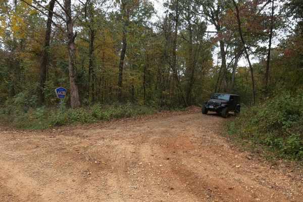
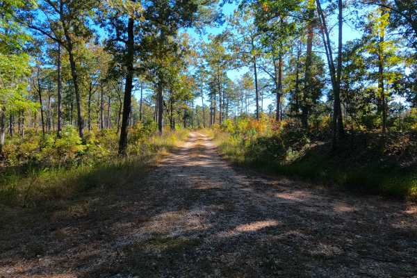
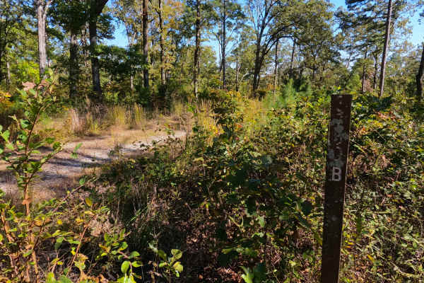
Gulf - FS 3821
Gulf FS 3821, or Wayne County Road 443B, is a natural attraction access, gravel-based, forestry road in the Poplar Bluff Unit of Mark Twain National Forrest. It is a well-maintained gravel road that is very simplistic and scenic, featuring a subtle grade down into the valley bottoms where a parking ...
Learn more about Gulf - FS 3821
East Kelly Ridge
East Kelly Ridge, designated as Forest Service Road 3077 branching off from Kelly Ridge, offers a journey through well-maintained gravel paths. In the summer, parts of the trail may be partially obscured by tall grass growth. Expect narrow sections along the route that may leave pinstripes on vehicl...
Learn more about East Kelly Ridge
Lone Star School Road (FS 3824)
This is a great trail that leads you to Granite Bend of Black River. There are several washouts on the main gravel of this trail but are easily passable, there are also several low water crossings with concrete bottoms that were about 6-12'' deep. This trail is a single-lane trail for the most part ...
Learn more about Lone Star School Road (FS 3824)
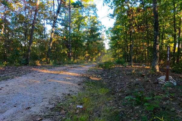
New Prospect - FS 3813
New Prospect (FS 3813) is a semi-maintained gravel Forest Service road within the Poplar Bluff Unit of Mark Twain National Forest. New Prospect likely gets its name from the former School of the same name to the east, which likely got its name from the 3 mines that existed in the area on its west en...
Learn more about New Prospect - FS 3813
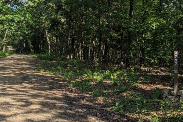
Little Brushy Ridge
Little Brushy Ridge (FSR 3797) is a forest service road branching off Kelly Ridge (FSR 3075). Initially, it is a well-maintained gravel road for the first 3/4 of the trail, suitable for all vehicle types without concern. At this point, an open area appears where the trail veers to the right. This ar...
Learn more about Little Brushy Ridge
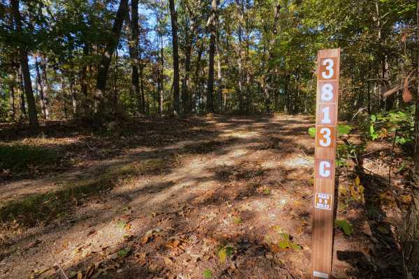
Prospect C - FS 3813C
Prospect C (FS 3813C) is a low-standard natural gravel and dirt forest service road, within the Poplar Bluff Unit of Mark Twain National Forest. The road begins at the intersection with the New Prospect FS 3813 and Prospect B (FS 3813B), where Prospect C continues eastward, gradually going downhill,...
Learn more about Prospect C - FS 3813C
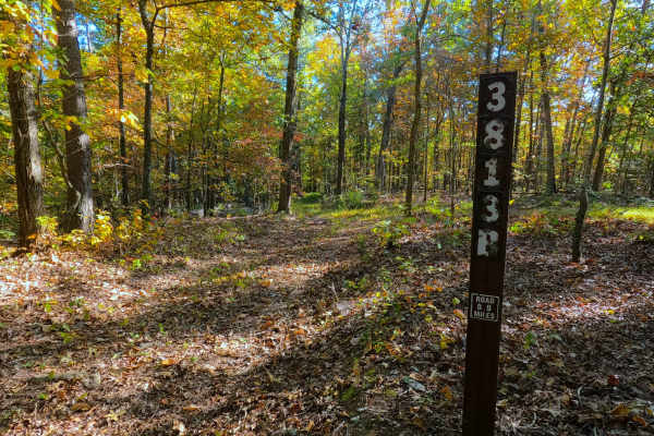
Prospect B - FS 3813B
Prospect B (FS 3813B) is a low-standard natural gravel and dirt forest service road within the Poplar Bluff Unit of Mark Twain National Forest. The road heads south from the New Prospect (FS 3813), featuring mild grade changes, as the road surface fades quickly from maintained gravel into natural co...
Learn more about Prospect B - FS 3813B
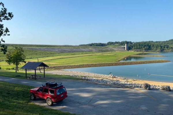
Clearwater Lake Dam Road
The Clearwater Lake Dam Road is a gravel-to-dirt road that traverses the low-laying bottoms along the Clearwater Lake side of the dam. This is a part of the Piedmont Park Campground Area managed by the US Army Corps of Engineers. The road is short and sweet, offering only a quick taste of what this ...
Learn more about Clearwater Lake Dam Road
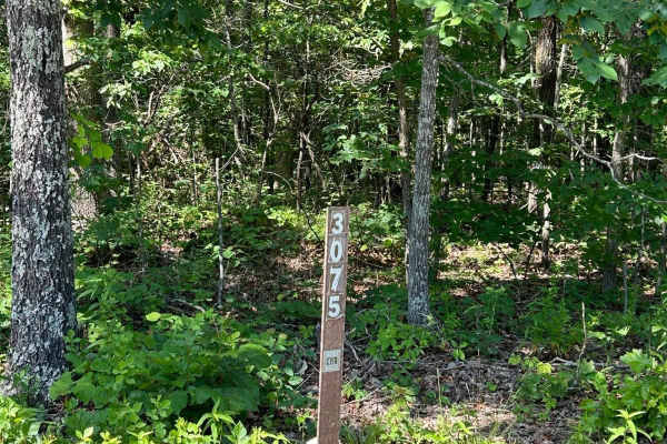
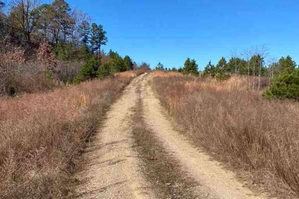
Kelly Ridge- FSR 3075
Kelly Ridge, located within the Mark Twain National Forest, is Forest Service Road 3075 located off Highway A, between Williamsville and Ellsinore. This scenic off-road trail predominantly consists of gravel and is generally well-maintained. While there are a couple of small washouts along the route...
Learn more about Kelly Ridge- FSR 3075
High Ridge - FS 3750
High Ridge (FS 3750) is a semi-maintained gravel forest service road within the Poplar Bluff Unit of Mark Twain National Forest, with seasonal open dates of 6-1 to 3-14 yearly. The High Ridge Road begins leaving the Wayne County Road 426, heading east past a closure gate, onto the ridge road, lined ...
Learn more about High Ridge - FS 3750
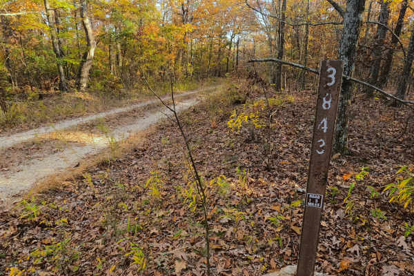
Tango - FS 3843B
Tango (FS 3843B) is a semi-maintained gravel Forest Service road within the Poplar Bluff Unit of Mark Twain National Forest. Tango takes off from the Foxtrot (FS 3843) heading south towards the Otter Creek valley to the south. The road consists of dropping down some moderate grades, over natural coa...
Learn more about Tango - FS 3843B

Reynolds - CR 468
The Reynolds County Road 468, what could be known as the Lower or South Black River Bottoms Access Road, is a gravel-based county road that makes its way through the US Army Corps of Engineers Land on the east side of Black River. It features scenic views of the hilly river landscape of the area it ...
Learn more about Reynolds - CR 468
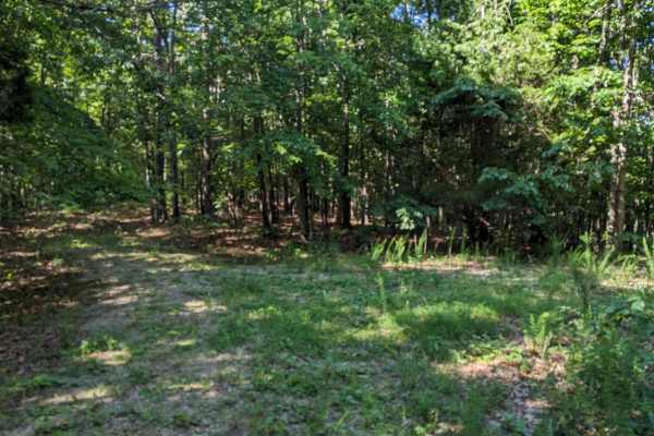
West Brown's Hollow
This trail splits off from Brown's Hollow and starts off as a well-maintained gravel Forest Service road. When following this road, you will come to an open and relatively flat area large enough for 1-3 vehicles to set up camp. Beyond this open area, the trail narrows significantly. If you proceed p...
Learn more about West Brown's Hollow

FSR 3136- Brown's Ridge
FSR 3136 is a well-maintained Forest Service road with a gravel surface. This trail winds through the dense forest and offers the chance to see wildlife such as deer, turkey, turtles, etc. At the end of this trail, there is an open area large enough for 1-2 vehicles to camp. The trail is easy enough...
Learn more about FSR 3136- Brown's Ridge
Miller Creek - FS 3750B
Miller Creek (FS 3750B) is a dirt and gravel forest service road within the Poplar Bluff Unit of Mark Twain National Forest, and is seasonally open from 6/1 to 3/14 yearly. Miller Creek leaves the ridge top along the western end of the High Ridge FS 3750, heading south downhill going over mild erosi...
Learn more about Miller Creek - FS 3750B

Fox Trot - FS 3843
Fox Trot (FS 3843) is a semi-maintained gravel Forest Service road within the Poplar Bluff Unit of Mark Twain National Forest. Fox Trot takes off from the Wayne County 403 heading west towards the Otter Creek Valley, following the small elevation changes of the lower spines of the ridge, passing by ...
Learn more about Fox Trot - FS 3843
Bee Ridge FSR 3844/3844C
Bee Ridge FSR 3844 & 3844C are two forestry roads that seamlessly connect to form a fun little trek through Mark Twain National Forest. The 3844 part of the trail is a well wore in gravel road with dirt patches. It starts right off the edge of US-67 and shortly after takes you up a small rutted incl...
Learn more about Bee Ridge FSR 3844/3844C

Emmatrude - FS 5820
Emmatrude FS 5820, also known as Kneibert Spring, is a gravel road within the Mark Twain National Forest Poplar Bluff Unit. The road features a ridge-top entry, leading to the valley below, featuring well-maintained gravel on the flat portions, with mild forms of erosion and coarser rock on the mode...
Learn more about Emmatrude - FS 5820

Charlton Bluff/Seematter Hollow Road
The Charlton Bluff/Seematter Hollow Road is a US Army Corps of Engineers Road that leads down into the eastern shore bottoms of the Black River, where Charlton Bluff sticks out towards the river on the west side shoreline. The road first begins by passing the Seematter Cemetery, right after you turn...
Learn more about Charlton Bluff/Seematter Hollow Road

Lakeview - FS 3827
Lakeview FS 3827 is a gravel Forest Service road within the Poplar Bluff Unit of Mark Twain National Forest. Foreshadowed by its name, Lakeview is placed high up on the ridges above Emmatrude FS 5820, which itself suggests what both roads serviced, the former Emmatrude Lake. Lakeview, in its past fo...
Learn more about Lakeview - FS 3827
Beginner ATV trails near Mill Spring, Missouri
Explore ATV-friendly trails near you. These trails are accessible for vehicles up to 50 inches wide, perfect for ATVs and smaller off-road machines.
East Kelly Ridge
East Kelly Ridge, designated as Forest Service Road 3077 branching off from Kelly Ridge, offers a journey through well-maintained gravel paths. In the summer, parts of the trail may be partially obscured by tall grass growth. Expect narrow sections along the route that may leave pinstripes on vehicl...
Learn more about East Kelly Ridge
Little Brushy Ridge
Little Brushy Ridge (FSR 3797) is a forest service road branching off Kelly Ridge (FSR 3075). Initially, it is a well-maintained gravel road for the first 3/4 of the trail, suitable for all vehicle types without concern. At this point, an open area appears where the trail veers to the right. This ar...
Learn more about Little Brushy Ridge
Prospect C - FS 3813C
Prospect C (FS 3813C) is a low-standard natural gravel and dirt forest service road, within the Poplar Bluff Unit of Mark Twain National Forest. The road begins at the intersection with the New Prospect FS 3813 and Prospect B (FS 3813B), where Prospect C continues eastward, gradually going downhill,...
Learn more about Prospect C - FS 3813C
Prospect B - FS 3813B
Prospect B (FS 3813B) is a low-standard natural gravel and dirt forest service road within the Poplar Bluff Unit of Mark Twain National Forest. The road heads south from the New Prospect (FS 3813), featuring mild grade changes, as the road surface fades quickly from maintained gravel into natural co...
Learn more about Prospect B - FS 3813B
Beginner UTV/side-by-side trails near Mill Spring, Missouri
Find UTV and side-by-side trails near you. These trails accommodate vehicles up to 60 inches wide, ideal for UTVs, side-by-sides, and wider off-road rigs.
East Kelly Ridge
East Kelly Ridge, designated as Forest Service Road 3077 branching off from Kelly Ridge, offers a journey through well-maintained gravel paths. In the summer, parts of the trail may be partially obscured by tall grass growth. Expect narrow sections along the route that may leave pinstripes on vehicl...
Learn more about East Kelly Ridge
New Prospect - FS 3813
New Prospect (FS 3813) is a semi-maintained gravel Forest Service road within the Poplar Bluff Unit of Mark Twain National Forest. New Prospect likely gets its name from the former School of the same name to the east, which likely got its name from the 3 mines that existed in the area on its west en...
Learn more about New Prospect - FS 3813
Little Brushy Ridge
Little Brushy Ridge (FSR 3797) is a forest service road branching off Kelly Ridge (FSR 3075). Initially, it is a well-maintained gravel road for the first 3/4 of the trail, suitable for all vehicle types without concern. At this point, an open area appears where the trail veers to the right. This ar...
Learn more about Little Brushy Ridge
Prospect C - FS 3813C
Prospect C (FS 3813C) is a low-standard natural gravel and dirt forest service road, within the Poplar Bluff Unit of Mark Twain National Forest. The road begins at the intersection with the New Prospect FS 3813 and Prospect B (FS 3813B), where Prospect C continues eastward, gradually going downhill,...
Learn more about Prospect C - FS 3813C
The onX Offroad Difference
onX Offroad combines trail photos, descriptions, difficulty ratings, width restrictions, seasonality, and more in a user-friendly interface. Available on all devices, with offline access and full compatibility with CarPlay and Android Auto. Discover what you're missing today!
Open Trail Map