
Beginner Off-Road Trails
Near Hartland, Michigan
Explore All Beginner Trails Near Hartland, Michigan
Beginner Off-Road Trails Near Hartland, Michigan
Discover the best beginner-friendly off-road trails near you. These easier, lower-rated trails are a great place to start — browse trail maps, check difficulty ratings, and find your next adventure.
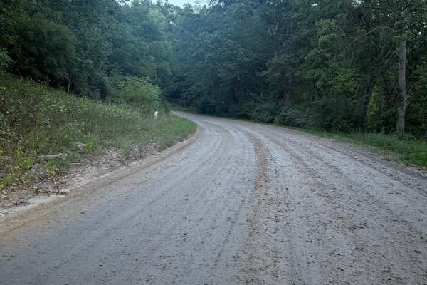
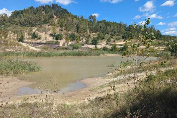
King Brighton Trail
King Brighton Trail is a really fun and exciting 2-mile bidirectional trail right outside the Brighton State Rec Area. Located just west of Chilson, right off Brighton Road, this trail is easily accessible. Starting from the northern end, you'll start out on a mostly dirt road for the first mile or ...
Learn more about King Brighton Trail

Rec Trail
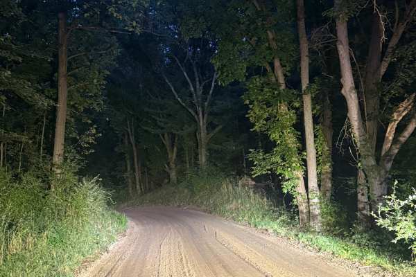
Rec Trail is a very fun and scenic 3-mile bidirectional road within the Brighton State Rec Area. Located west of King Road, this trail is easily accessible. Starting from the east end at the intersection of King Road and East Schafer Road, you'll start out on a smooth, packed dirt road that leads in...
Learn more about Rec Trail
Brady Trail
Brady Trail is an easy one-mile bidirectional road, yet scenic in its own way. Located within the Brighton State Rec Area south of Genoa Charter Township, this trail is easily accessible. Starting from the southern end at the intersection of East Schafer Rd, you'll start on a mostly compact dirt roa...
Learn more about Brady Trail
Brighton Trail
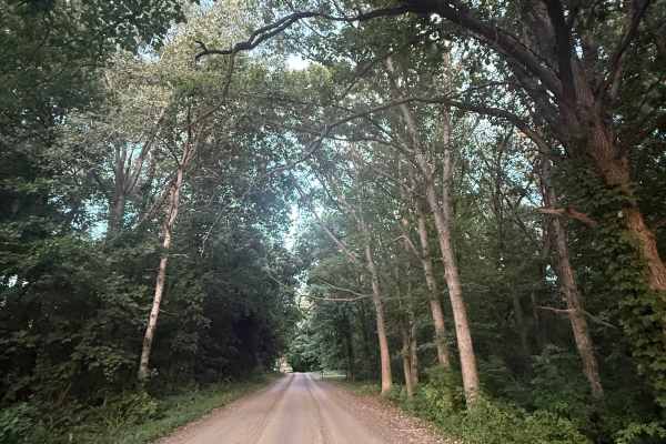
Brighton Trail is an exciting and fun bidirectional 3-mile road just outside of the Brighton State Rec Area. Located just south of both Coon and Pardee Lake, this trail is easily accessible. Starting from the western end of Pinckey Road, you'll start out in a thick section of trees with lush vegetat...
Learn more about Brighton Trail

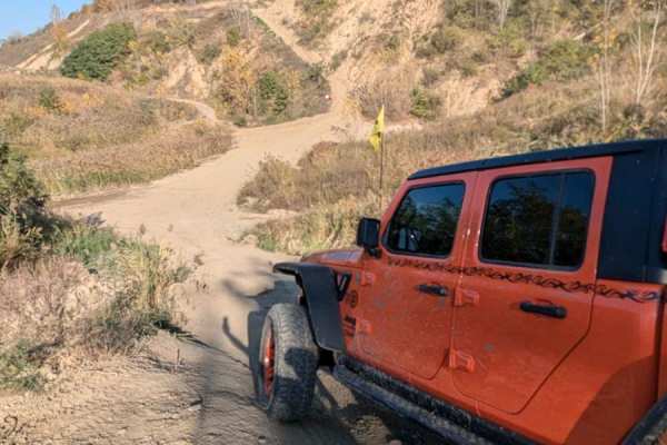
Gawkers Pass
Gawkers Pass is a short incline/descent trail that runs between Mount Magna and Soggy Bottom Loop. It is steep and can get washed out easily. There are also a few rocks along the trail. This trail runs right next to The Notch and can be a great place to watch the buggies give The Notch a go!
Learn more about Gawkers Pass
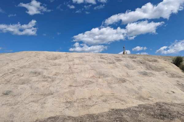
Mount Magna Loop
This trail runs along the entire base of Mount Magna. It is a trail that gives access to anyone who wants to try the many routes to the top of Mount Magna. Mount Magna is a concrete area that was designed to simulate obstacles that can be found out west. Those obstacles are;Hot Tub, Potato Salad, Ba...
Learn more about Mount Magna Loop
Noyes Boulevard
Noyes Boulevard is a main road that connects the front of the park with the Mount Magna area and the back of the park. There is a westbound and eastbound road, and they are directional. This is a high-traffic route so pay attention to the direction of the traffic.
Learn more about Noyes Boulevard
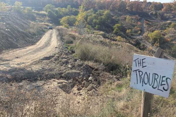
The Troubles
This is an intermediate trail with a hill descent or climb and a little off-camber areas. It is a multi-directional trail. One end can be found on Skyline Drive and the other can be located on South Rim Road. As with any of the trails at Holly Oaks, this trail could be more difficult if you run it g...
Learn more about The Troubles
Sloppy Joe Bypass
This trail is an easy trail that connects to the middle of The Troubles trail. It runs along the hillside where you can find the Sloppy Joe trail and connects to the Catwalk. This trail is easy, but in true Holly Oaks fashion, it can be muddy if the trail has been wet.
Learn more about Sloppy Joe Bypass
Big Trouble
The trail is multi-directional and can be picked up near the bottom of Sloppy Joe or off of The Troubles. This trail is an intermediately steep trail and rutted. As with any of the Holly Oak trails, this could be slippery if wet. The trail is narrow in some spots and the brush may be a little overgr...
Learn more about Big Trouble
Soggy Bottom Loop
Soggy Bottom Loop is a moderate trail that runs through an area that can be very wet. There are tracks going through the water in some areas of the loop. The recorded track is a loop that DOES NOT go into the water. As with some of the trails in the park, sometimes the trail does get some grading or...
Learn more about Soggy Bottom Loop
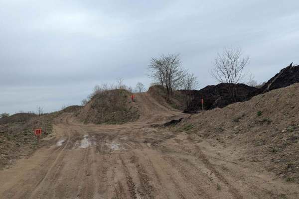
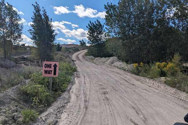
Endurance Trail
The Endurance Trail begins at the intersection in the middle of the park. It is a ONE-WAY trail. It starts with a short hill climb on the edge of the Flat Top area and then circles to the major intersection in the upper portion of the park. It is well marked in the park and easy to follow. Please no...
Learn more about Endurance Trail
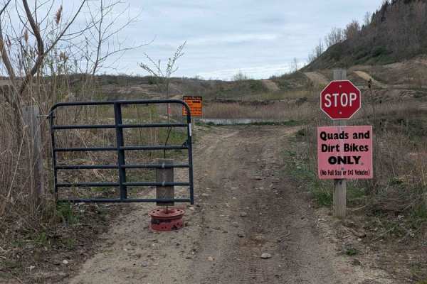
The Bathtub
This track is for dirt bikes and quads only and it's gated to limit access to anyone other than those vehicles. It is a short loop with moderate hills and small banked turns. The track runs around a water hole that look to be very deep. Riders are not allowed to enter the water. The track is ONE WAY...
Learn more about The Bathtub
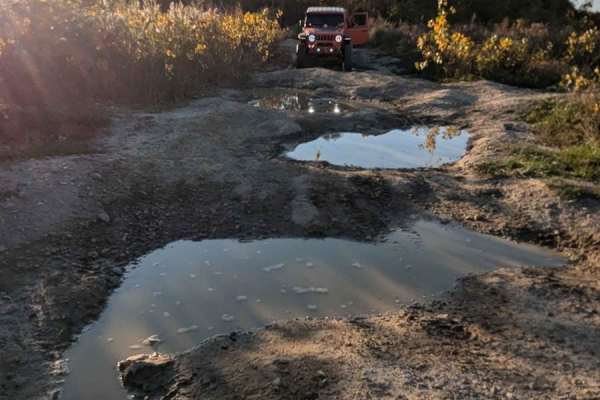
West Point Hill Climb
This trail is multi-directional, steep, and with large bumps causing your vehicle to articulate. Either entrance to this trail can be located along the South Rim Trail. The trail is very rutted. There was standing water on the trail and it has been dry. The trail would be very challenging if it was ...
Learn more about West Point Hill Climb
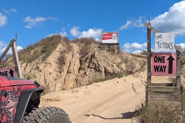
The Tetons
The Tetons can be found just to the right when you first drop into the offroad area of the park. It is a short trail that has two steep sandy hill climbs back to back. The trail is directional and there is a stop sign at the end. This trail is also a part of the Endurance Route, which is a combinati...
Learn more about The Tetons
Top Line
This moderate trail is sandy. It is multi-directional and can be found at the end of Skyline Drive, or at the top of the Electric Slide. This trail also runs next to Rats Nest and Rim Cut. All three trails will dump you out in the same area at the top of Electric Slide.
Learn more about Top Line
Darlene's Ridge
There are three entrances to this short trail off of Skyline Drive. It is directional. There are some small rocks along the trail but nothing a stock vehicle can't handle. This route is a good alternative to the Skyline trail if you are headed from the front of the park to the back.
Learn more about Darlene's Ridge
Rat's Nest
This is a short sandy trail that can be found at the end of Skyline Ridge and is a connector trail to Rim Cut. There are no elevation changes, but it does drop into the entrance to the Electric Slide. Electric Slide is a one-way trail going down.
Learn more about Rat's Nest
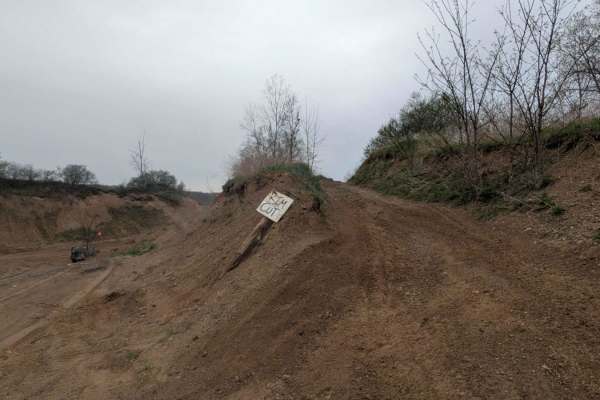
Rim Cut
Rim Cut is a short sandy connector trail that can be found at the end of Skyline Trail. It is next to Top Line and Rat's Nest. It also loops at the top of the Electric Slide entrance. It does have a small area that is beginning to get washed out.
Learn more about Rim Cut
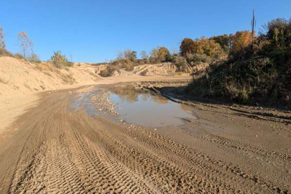
Katy's Loop
This trail is sandy with little rocks and loops around the far back area of the park. It's easy to drive and in most areas wide enough for two vehicles. There is a section near the Northwest Corner that has standing water. The water can be deep if it's been wet. Be cautious. The trail currently dead...
Learn more about Katy's Loop
Beginner ATV trails near Hartland, Michigan
Explore ATV-friendly trails near you. These trails are accessible for vehicles up to 50 inches wide, perfect for ATVs and smaller off-road machines.
Gawkers Pass
Gawkers Pass is a short incline/descent trail that runs between Mount Magna and Soggy Bottom Loop. It is steep and can get washed out easily. There are also a few rocks along the trail. This trail runs right next to The Notch and can be a great place to watch the buggies give The Notch a go!
Learn more about Gawkers Pass
Mount Magna Loop
This trail runs along the entire base of Mount Magna. It is a trail that gives access to anyone who wants to try the many routes to the top of Mount Magna. Mount Magna is a concrete area that was designed to simulate obstacles that can be found out west. Those obstacles are;Hot Tub, Potato Salad, Ba...
Learn more about Mount Magna Loop
Noyes Boulevard
Noyes Boulevard is a main road that connects the front of the park with the Mount Magna area and the back of the park. There is a westbound and eastbound road, and they are directional. This is a high-traffic route so pay attention to the direction of the traffic.
Learn more about Noyes Boulevard
The Troubles
This is an intermediate trail with a hill descent or climb and a little off-camber areas. It is a multi-directional trail. One end can be found on Skyline Drive and the other can be located on South Rim Road. As with any of the trails at Holly Oaks, this trail could be more difficult if you run it g...
Learn more about The Troubles
Beginner UTV/side-by-side trails near Hartland, Michigan
Find UTV and side-by-side trails near you. These trails accommodate vehicles up to 60 inches wide, ideal for UTVs, side-by-sides, and wider off-road rigs.
Gawkers Pass
Gawkers Pass is a short incline/descent trail that runs between Mount Magna and Soggy Bottom Loop. It is steep and can get washed out easily. There are also a few rocks along the trail. This trail runs right next to The Notch and can be a great place to watch the buggies give The Notch a go!
Learn more about Gawkers Pass
Mount Magna Loop
This trail runs along the entire base of Mount Magna. It is a trail that gives access to anyone who wants to try the many routes to the top of Mount Magna. Mount Magna is a concrete area that was designed to simulate obstacles that can be found out west. Those obstacles are;Hot Tub, Potato Salad, Ba...
Learn more about Mount Magna Loop
Noyes Boulevard
Noyes Boulevard is a main road that connects the front of the park with the Mount Magna area and the back of the park. There is a westbound and eastbound road, and they are directional. This is a high-traffic route so pay attention to the direction of the traffic.
Learn more about Noyes Boulevard
The Troubles
This is an intermediate trail with a hill descent or climb and a little off-camber areas. It is a multi-directional trail. One end can be found on Skyline Drive and the other can be located on South Rim Road. As with any of the trails at Holly Oaks, this trail could be more difficult if you run it g...
Learn more about The Troubles
The onX Offroad Difference
onX Offroad combines trail photos, descriptions, difficulty ratings, width restrictions, seasonality, and more in a user-friendly interface. Available on all devices, with offline access and full compatibility with CarPlay and Android Auto. Discover what you're missing today!
Open Trail Map