Beginner Off-Road Trails Near La Junta, Colorado
Explore All Beginner Trails Near La Junta, Colorado
NE Passage via Cimarron Canyon
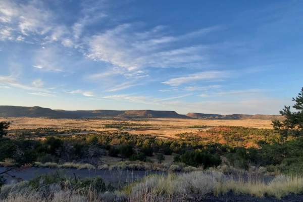
This is a very long dirt road route connecting Clayton Lake State Park NM and Trinidad, Colorado. There is a shortcut that will eliminate approximately 20 miles (if you look at the route closely, it's…
Learn more about NE Passage via Cimarron Canyon
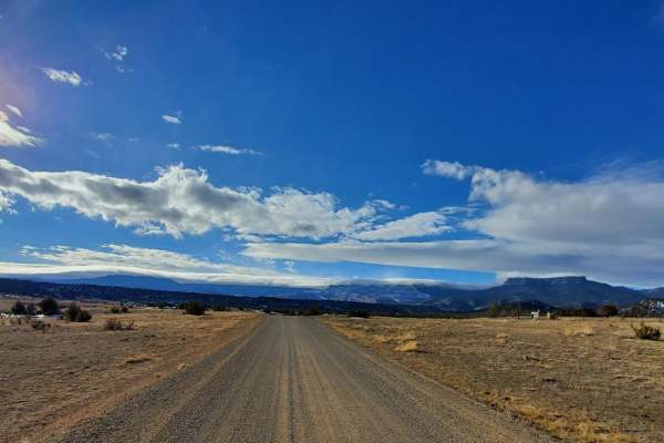
Total Miles
112.4
Tech Rating
Best Time
Sp / Fa / Su / Wi
Trinchera Pass
Total Miles
42.2
Tech Rating
Best Time
Sp / Su / Fa
San Carlos Road
This trail is a short, easy out-and-back route that winds through the small elevation changes of the Wet Mountain foothills and offers a good chance of isolation. It contains no major obstacles or water crossings,…
Learn more about San Carlos Road
Total Miles
2.9
Tech Rating
Best Time
Su / Fa
Old Stage Rd
Total Miles
5
Tech Rating
Best Time
Sp
Gold Camp Rd to Cripple Creek
Total Miles
19.9
Tech Rating
Best Time
Sp / Su / Fa
6102i
6102i departs from 6201F and goes over a bunch of slick rock layers, with a couple of 6" tall rock ledges right away. The rest of the short trail has small loose rocks, more flat…
Learn more about 6102i
Total Miles
0.4
Tech Rating
Best Time
Sp / Su / Fa / Wi
Penrose Commons BLM 6102E
Penrose Commons OHV Trail 6102E is a trail that runs north/south through the middle of the Penrose Commons OHV recreational site. The majority of the trail traverses along the top edge of a valley overlooking…
Learn more about Penrose Commons BLM 6102E
Total Miles
1.3
Tech Rating
Best Time
Sp / Fa / Wi
Greenhorn Mountain Road_ Forest Road 639
This is a wide gravel road that you can use to connect many trails in the area. To make loop routes you can go down Meadow Divide forest road 639 then come back up Salt…
Learn more about Greenhorn Mountain Road_ Forest Road 639
Total Miles
4.4
Tech Rating
Best Time
Sp / Su / Fa
Beaver Creek Lookout - BLM#6102J
Trail#6102J is one of two sites drivable by a full-size 4x4 towards a scenic site where you can see Patton Canyon and Beaver Creek in the valley below as well as ruins of an old…
Learn more about Beaver Creek Lookout - BLM#6102J
Total Miles
0.1
Tech Rating
Best Time
Sp / Fa / Wi
Cucharas Pass
Total Miles
12.7
Tech Rating
Best Time
Su / Fa
Patton Canyon Lookout - BLM#6102H
Trail#6102H is one of two sites drivable by a full-size 4x4 towards a scenic site where you can see Patton Canyon and Beaver Creek in the valley below as well as ruins of an old…
Learn more about Patton Canyon Lookout - BLM#6102H
Total Miles
0.1
Tech Rating
Best Time
Sp / Fa / Wi
Lower Gold Camp Road
Dirt roads with some rocks scattered throughout. Good road that is easily accessible from Colorado Springs that virtually any car can handle. Multiple tunnels going through the mountains. Majority is two lane with multiple spots…
Learn more about Lower Gold Camp Road
Total Miles
5.4
Tech Rating
Best Time
Su / Fa
6102G
This trail is a short finger that runs down off the main loop (6102) in the Penrose Commons. Uneventful and flat. After a good rain, mud will be present. The end of the trail turns…
Learn more about 6102G
Total Miles
0.4
Tech Rating
Best Time
Sp / Su / Fa / Wi
6102A
This ATV trail starts off of BLM Route 6102, just north of the Penrose Commons parking lot. It starts as a flat two-track with small loose rocks, going through wide open grassy terrain with pinyon…
Learn more about 6102A
Total Miles
1.6
Tech Rating
Best Time
Su / Sp / Fa / Wi
Penrose Commons BLM#6102A
Penrose Commons OHV Trail# 6102A is the trail that overlooks a narrow valley where the famous Patriot trails traverse (Independence Trail, Patriot Trail, and Liberty Trail). Although this trail connects the well-known extreme 4x4 trail,…
Learn more about Penrose Commons BLM#6102A
Total Miles
1.1
Tech Rating
Best Time
Sp / Fa / Wi
Roundtop Mountain Road - 321
This is a USFS road in the San Carlos Ranger District. The road is accessed off of CO-165 via Ditch Creek Rd. The road is an out-and-back trail that offers access to multiple dispersed camping…
Learn more about Roundtop Mountain Road - 321
Total Miles
1.7
Tech Rating
Best Time
Sp / Su / Fa
6102D
This easy trail winds through Penrose Commons, crossing varied terrain with gentle elevation changes. The north end features scattered large rocks and small steps among cedar trees, while the south end passes through an open…
Learn more about 6102D
Total Miles
0.7
Tech Rating
Best Time
Sp / Su / Fa / Wi
Turkey Creek Forest Road 637
This is an easy winding road that has a few rocky spots that are easy to get around. The road takes you through open meadows and then through forest areas. It has nice views across…
Learn more about Turkey Creek Forest Road 637
Total Miles
3
Tech Rating
Best Time
Sp / Su / Fa
Forest Road 630/Williams Creek
This road is fairly easy as it is a county/Forest Service road that gives you access to several jeep trails, hiking, dispersed camping, and mountain biking trails. The road travels through open pasture lands with…
Learn more about Forest Road 630/Williams Creek
Total Miles
8.5
Tech Rating
Best Time
Su / Fa / Sp
Meadow Divide Road- FSR 325
This is an easy trail that takes you through areas of meadows at the top and bottom with forested areas in the middle. There are spots where there is some logging operation in progress. At…
Learn more about Meadow Divide Road- FSR 325
Total Miles
9.7
Tech Rating
Best Time
Sp / Su / Fa
Mount Baldy
Total Miles
5.9
Tech Rating
Best Time
Su / Fa
Mt. Herman & Rampart Range Roads
This section of Rampart Range Road is nicely maintained and provides amazing scenery as you drop into the Garden of the Gods Park. The route starts where Mt. Herman Road, the Schubarth Loop, and Range…
Learn more about Mt. Herman & Rampart Range Roads
Total Miles
33.7
Tech Rating
Best Time
Su / Fa
Shelf Road, Phantom Canyon
Total Miles
57.7
Tech Rating
Best Time
Su / Fa
Old La Veta Pass
This trail is an old train route that connected the east and west sides of the Sangre de Cristo mountains until the 1960s when the highway was put in. It is now an unmaintained road…
Learn more about Old La Veta Pass
Total Miles
5.2
Tech Rating
Best Time
Sp / Su / Fa
Medano's Back Door
This is a well-maintained graded dirt road. It will be passable for any road-worthy vehicle in good weather conditions. If poor weather does occur, it could be trouble for road cars. A 4x4 with clearance…
Learn more about Medano's Back Door
Total Miles
16.1
Tech Rating
Best Time
Sp / Su / Fa / Wi
Fan Dike
Total Miles
2.9
Tech Rating
Best Time
Su / Fa
Steep Mountain
Total Miles
0.9
Tech Rating
Best Time
Sp / Su / Fa
Oil well Flats RD BLM 5941
The road at the beginning is easy, about halfway you encounter a short rocky section. It gets easy until you get within about a 1/2 mile of the end where it drops down a fairly…
Learn more about Oil well Flats RD BLM 5941
Total Miles
1.8
Tech Rating
Best Time
Sp / Su / Fa / Wi
Oil Well Flats Road BLM 5940
The road is easy on the lower sections, however, it can get muddy after wet weather. On the upper section toward the end, there is a rocky area that requires high clearance. The road ends…
Learn more about Oil Well Flats Road BLM 5940
Total Miles
1.4
Tech Rating
Best Time
Wi / Fa / Su / Sp
Dinosaur Flats Road BLM#5935
Road a little rutted at start-up to T intersection. Turning right and staying on 5935 as you get higher it gets rocker in some places. The roads can get muddy after wet weather. If it…
Learn more about Dinosaur Flats Road BLM#5935
Total Miles
2.8
Tech Rating
Best Time
Sp / Su / Fa / Wi
ATV Trails Near La Junta, Colorado
San Carlos Road
This trail is a short, easy out-and-back route that winds through the small elevation changes of the Wet Mountain foothills and offers a good chance of isolation. It contains no major obstacles or water crossings,…
Learn more about San Carlos Road
Total Miles
2.9
Tech Rating
Best Time
Su / Fa
6102i
6102i departs from 6201F and goes over a bunch of slick rock layers, with a couple of 6" tall rock ledges right away. The rest of the short trail has small loose rocks, more flat…
Learn more about 6102i
Total Miles
0.4
Tech Rating
Best Time
Sp / Su / Fa / Wi
Penrose Commons BLM 6102E
Penrose Commons OHV Trail 6102E is a trail that runs north/south through the middle of the Penrose Commons OHV recreational site. The majority of the trail traverses along the top edge of a valley overlooking…
Learn more about Penrose Commons BLM 6102E
Total Miles
1.3
Tech Rating
Best Time
Sp / Fa / Wi
Beaver Creek Lookout - BLM#6102J
Trail#6102J is one of two sites drivable by a full-size 4x4 towards a scenic site where you can see Patton Canyon and Beaver Creek in the valley below as well as ruins of an old…
Learn more about Beaver Creek Lookout - BLM#6102J
Total Miles
0.1
Tech Rating
Best Time
Sp / Fa / Wi
Patton Canyon Lookout - BLM#6102H
Trail#6102H is one of two sites drivable by a full-size 4x4 towards a scenic site where you can see Patton Canyon and Beaver Creek in the valley below as well as ruins of an old…
Learn more about Patton Canyon Lookout - BLM#6102H
Total Miles
0.1
Tech Rating
Best Time
Sp / Fa / Wi
6102G
This trail is a short finger that runs down off the main loop (6102) in the Penrose Commons. Uneventful and flat. After a good rain, mud will be present. The end of the trail turns…
Learn more about 6102G
Total Miles
0.4
Tech Rating
Best Time
Sp / Su / Fa / Wi
UTV/Side-by-Side Near La Junta, Colorado
San Carlos Road
This trail is a short, easy out-and-back route that winds through the small elevation changes of the Wet Mountain foothills and offers a good chance of isolation. It contains no major obstacles or water crossings,…
Learn more about San Carlos Road
Total Miles
2.9
Tech Rating
Best Time
Su / Fa
Penrose Commons BLM 6102E
Penrose Commons OHV Trail 6102E is a trail that runs north/south through the middle of the Penrose Commons OHV recreational site. The majority of the trail traverses along the top edge of a valley overlooking…
Learn more about Penrose Commons BLM 6102E
Total Miles
1.3
Tech Rating
Best Time
Sp / Fa / Wi
Beaver Creek Lookout - BLM#6102J
Trail#6102J is one of two sites drivable by a full-size 4x4 towards a scenic site where you can see Patton Canyon and Beaver Creek in the valley below as well as ruins of an old…
Learn more about Beaver Creek Lookout - BLM#6102J
Total Miles
0.1
Tech Rating
Best Time
Sp / Fa / Wi
Patton Canyon Lookout - BLM#6102H
Trail#6102H is one of two sites drivable by a full-size 4x4 towards a scenic site where you can see Patton Canyon and Beaver Creek in the valley below as well as ruins of an old…
Learn more about Patton Canyon Lookout - BLM#6102H
Total Miles
0.1
Tech Rating
Best Time
Sp / Fa / Wi
6102G
This trail is a short finger that runs down off the main loop (6102) in the Penrose Commons. Uneventful and flat. After a good rain, mud will be present. The end of the trail turns…
Learn more about 6102G
Total Miles
0.4
Tech Rating
Best Time
Sp / Su / Fa / Wi
Penrose Commons BLM#6102A
Penrose Commons OHV Trail# 6102A is the trail that overlooks a narrow valley where the famous Patriot trails traverse (Independence Trail, Patriot Trail, and Liberty Trail). Although this trail connects the well-known extreme 4x4 trail,…
Learn more about Penrose Commons BLM#6102A
Total Miles
1.1
Tech Rating
Best Time
Sp / Fa / Wi