Beginner Off-Road Trails Near Bascom, Ohio

Explore All Beginner Trails Near Bascom, Ohio

Bridge of Dreams to Mohican River

Fantastic rolling gravel along Kokosing River. There are multiple springs for filling water along the southern edge of the route. Some sections to this can be very high speed if graded well. New canoe access…
Learn more about Bridge of Dreams to Mohican River
Total Miles
5.9
Tech Rating
2 Easy
Best Time
Sp / Su / Fa

Bridge of Dreams to Hunter Steel Bridge

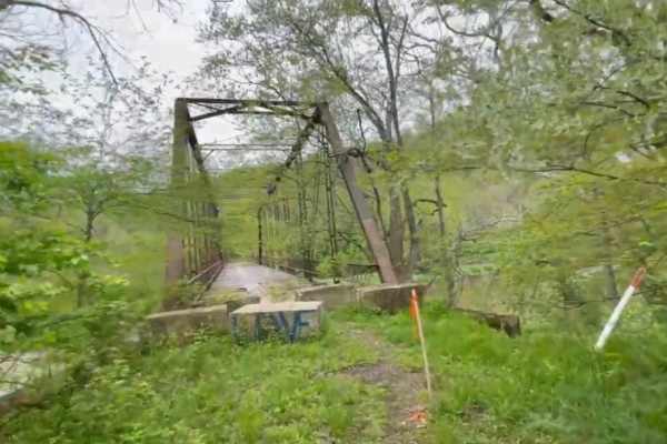
This is a narrow, graded winding gravel dirt mix that runs along the Kokosing River. Just after the roadside Springs, it changes Elevation to go up through a small patch of woods, and it drops…
Learn more about Bridge of Dreams to Hunter Steel Bridge
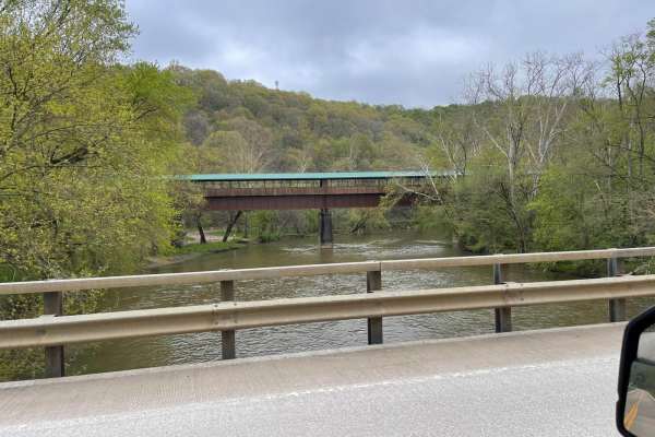
Total Miles
2
Tech Rating
2 Easy
Best Time
Sp / Su / Wi / Fa

Walhonding Hills Steel Bridge to Bridge of Dreams

This trail is a tertiary gravel road that winds through the Amish Community with significant changes in elevation and sharp terms. Be aware of oncoming vehicle horse and foot traffic in the area as it…
Learn more about Walhonding Hills Steel Bridge to Bridge of Dreams
Total Miles
4.3
Tech Rating
3 Easy
Best Time
Sp / Su / Wi / Fa

Walhonding Hills Steel Bridge to 715 Batnest Loop

This is a high-speed, secondary gravel road running along the Kokosing River. Expect to encounter significant changes in elevation, and some blind turns on the cliff edge. This area is public hunting so foraging for…
Learn more about Walhonding Hills Steel Bridge to 715 Batnest Loop
Total Miles
5.3
Tech Rating
1 Easy
Best Time
Su / Sp / Fa / Wi

Valley and Cows

Lots of scenic wooded gravel roads. Quite a bit of up and down on the side loops as you come in and out of the valley. We were rewarded at the end of this trip…
Learn more about Valley and Cows
Total Miles
10.6
Tech Rating
3 Easy
Best Time
Sp / Su / Fa / Wi

Batnest Loop

This is the eastern loop of Batnest Road back to Main Road 715. The nice twisty well-graded gravel road gets fairly steep in places. Hunting and fishing in the area with proper licensing, known for…
Learn more about Batnest Loop
Total Miles
2.3
Tech Rating
1 Easy
Best Time
Sp / Su / Fa / Wi

Amish Lumber Mills

These are some great winding country back roads going through Amish Country seeing several Amish lumber mills and roadside markets to purchase Amish produce and craft. With beautiful changes in elevation, some of these roads…
Learn more about Amish Lumber Mills
Total Miles
16.7
Tech Rating
2 Easy
Best Time
Sp / Su / Fa / Wi

McClure Trail

McClure Trail is an easy 2.4-mile bidirectional trail, yet scenic in its own way. Located within the Waterloo State Rec Area near Highway 74 between Jackson and Ann Arbor, this trail is easily accessible. Starting…
Learn more about McClure Trail
Total Miles
2.3
Tech Rating
Best Time
Sp / Su / Fa / Wi

Tiplady Trail

Tiplady Trail is an easy bidirectional trail within the Department of Natural Resources. Located just north of Dexter Township between Highway 96 and 94, this trail is easily accessible. This trail is also within the…
Learn more about Tiplady Trail
Total Miles
2.4
Tech Rating
Best Time
Sp / Su / Fa / Wi

Crooked Lake Trail

Crooked Lake Trail is a unique bidirectional trail within the Pinckney State Recreation Area. Located just north of Dexter Township between Highway 94 and Highway 96, this trail is easily accessible. Starting from the southern…
Learn more about Crooked Lake Trail
Total Miles
1.3
Tech Rating
Best Time
Sp / Su / Fa / Wi

Loveland Trail

Loveland Trail is an easy & scenic bidirectional 2.7-mile road. Located just off Highway 74, this route is easily accessible. This trail is typically easy with nothing technical, just a few spots that can become…
Learn more about Loveland Trail
Total Miles
2.5
Tech Rating
Best Time
Sp / Su / Fa / Wi

Leach Trail

Leach Trail is a really fun and exciting bidirectional trail within the Waterloo State Recreation Area. Located just off Highway 74 between Jackson and Ann Arbor, this trail is easily accessible. Starting from the eastern…
Learn more about Leach Trail
Total Miles
1.3
Tech Rating
Best Time
Sp / Su / Fa / Wi

Green Trail

Green Trail is a very interesting scenic bidirectional Natural Beauty Road within the Waterloo State Rec Area. Located between Jackson and Ann Arbor near Highway 94, this trail is easily accessible. Starting from the west…
Learn more about Green Trail
Total Miles
1.2
Tech Rating
Best Time
Sp / Su / Fa / Wi

Silver Hill Trail

Silver Hill Trail is a unique Michigan bidirectional trail within the Pinckney State Recreation Area. Located just south of Hell between Highway 96 and 94, this trail is easily accessible. Starting from the northern end…
Learn more about Silver Hill Trail
Total Miles
0.9
Tech Rating
Best Time
Sp / Su / Fa / Wi

Maute Trail

Maute Trail is an exciting 2.5-mile scenic bidirectional trail within the Waterloo State Recreation Area. Located near Highway 94 between Jackson and Ann Arbor, this trail is easily accessible. Starting from the south end off…
Learn more about Maute Trail
Total Miles
2.4
Tech Rating
Best Time
Sp / Su / Fa / Wi

Camp Trail

Camp Trail is a fun bidirectional trail just on the outskirts of the Waterloo Rec Area. Located east of Jackson near Highway 74, this trail is easily accessible. Starting from the eastern end of Cedar…
Learn more about Camp Trail
Total Miles
0.5
Tech Rating
Best Time
Sp / Su / Fa / Wi

Cedar Lake Trail

Cedar Lake Trail is an awesome 8-mile bidirectional trail within the Michigan Department of Natural Resources and right outside the Pickney State Rec Area. Located between Marion Township and Putnam Township, this trail is easily…
Learn more about Cedar Lake Trail
Total Miles
7.7
Tech Rating
Best Time
Sp / Su / Fa / Wi

Glenn East Trail

Glenn East Trail is a classical Michigan bi-directional trail within the Waterloo State Recreation Area. Located off Mount Hope Road, shortly off Highway 94, you'll find the west end of the trail, making it easily…
Learn more about Glenn East Trail
Total Miles
1.7
Tech Rating
Best Time
Sp / Su / Fa / Wi

Rush Lake Trail

Rush Lake Trail is a 1.5-mile bidirectional road. Located just south of Farley Road, this trail is easily accessible from some of the other nearby trails. Starting off, you'll begin on a dirt/gravel road that…
Learn more about Rush Lake Trail
Total Miles
1.6
Tech Rating
Best Time
Sp / Su / Fa / Wi

Chambers Trail

Chambers Trail is an easy and scenic 2.5-mile bidirectional road within the Brighton State Rec Area. Located just north of Rush Lake Road, this trail is easily accessible. Starting from the southern end of the…
Learn more about Chambers Trail
Total Miles
2.2
Tech Rating
Best Time
Sp / Su / Fa / Wi

Kelly Trail

Kelly Trail is everything you would think it is based on its name. This 2.7-mile bidirectional scenic trail has many things to offer. Located within the Pinckney State Rec Area between highway 96 and 94…
Learn more about Kelly Trail
Total Miles
2.6
Tech Rating
Best Time
Sp / Su / Fa / Wi

Monks Trail

Monks Trail is a 1.5-mile bidirectional trail within the Pinckney State Rec Area. Located between Cedar Lake Trail and Kelly Trail just south of Putnam Township, this trail is easily accessible. Starting from the western…
Learn more about Monks Trail
Total Miles
1.4
Tech Rating
Best Time
Sp / Su / Fa / Wi

Katz Trail

Katz Trail is a very fun and scenic bidirectional road within the Waterloo State Recreation Area. Located just off Highway 94, this trail is easily accessible. Starting from the north end, you'll start on a…
Learn more about Katz Trail
Total Miles
1.9
Tech Rating
Best Time
Sp / Su / Fa / Wi

Border Trail Part 2

The trail runs along the edge of the park and into the Whispering Woods. The trail is for SXS, ATVS, and motorcycles only. There are some mud holes and areas with tight trees. The trail…
Learn more about Border Trail Part 2
Total Miles
0.5
Tech Rating
3 Easy
Best Time
Sp / Su / Fa / Wi

Steinwinder

This trail has two designations: one for full-size rigs and one for ATVs. There are many markers to indicate which path is which. This trail is also one-way. There are many tight turns and it…
Learn more about Steinwinder
Total Miles
0.3
Tech Rating
2 Easy
Best Time
Sp / Su / Fa / Wi

Doyle Trail

Doyle Trail is an easy bidirectional trail within the Pinckney State Recreation Area. Located off Patterson Lake Rd between highway 96 and 94, you'll find the west end of the trail, making it easily accessible.…
Learn more about Doyle Trail
Total Miles
1.1
Tech Rating
Best Time
Sp / Su / Fa / Wi

Bare Back

The entrance to this trail can be picked up from the Lower Parking Lot and runs along the picnic area. This trail is mild with a couple of spots of articulation and a couple of…
Learn more about Bare Back
Total Miles
0.1
Tech Rating
2 Easy
Best Time
Sp / Su / Fa / Wi

Welcome Trail

This trail begins at the Lower Level Parking Lot and is a connector trail between one of the main roads that runs through the park and the parking lots. There are very few elevation changes.…
Learn more about Welcome Trail
Total Miles
0.2
Tech Rating
2 Easy
Best Time
Sp / Su / Fa / Wi

Little Willy

Little Willy is a mild trail that has few elevation changes. There is also an area that tends to get washed out when it's been raining. It's not very long and is a great trail…
Learn more about Little Willy
Total Miles
0.1
Tech Rating
2 Easy
Best Time
Sp / Su / Fa / Wi

Nut Check

Nut Check starts with an intermediate rock crawl in a washout. Then the trail branches off that washout and climbs up a hill. If someone prefers not to climb the hill, they can continue straight…
Learn more about Nut Check
Total Miles
0.3
Tech Rating
3 Easy
Best Time
Sp / Su / Fa / Wi

ATV Trails Near Bascom, Ohio

Border Trail Part 2

The trail runs along the edge of the park and into the Whispering Woods. The trail is for SXS, ATVS, and motorcycles only. There are some mud holes and areas with tight trees. The trail…
Learn more about Border Trail Part 2
Total Miles
0.5
Tech Rating
3 Easy
Best Time
Sp / Su / Fa / Wi

Steinwinder

This trail has two designations: one for full-size rigs and one for ATVs. There are many markers to indicate which path is which. This trail is also one-way. There are many tight turns and it…
Learn more about Steinwinder
Total Miles
0.3
Tech Rating
2 Easy
Best Time
Sp / Su / Fa / Wi

Bare Back

The entrance to this trail can be picked up from the Lower Parking Lot and runs along the picnic area. This trail is mild with a couple of spots of articulation and a couple of…
Learn more about Bare Back
Total Miles
0.1
Tech Rating
2 Easy
Best Time
Sp / Su / Fa / Wi

Welcome Trail

This trail begins at the Lower Level Parking Lot and is a connector trail between one of the main roads that runs through the park and the parking lots. There are very few elevation changes.…
Learn more about Welcome Trail
Total Miles
0.2
Tech Rating
2 Easy
Best Time
Sp / Su / Fa / Wi

Little Willy

Little Willy is a mild trail that has few elevation changes. There is also an area that tends to get washed out when it's been raining. It's not very long and is a great trail…
Learn more about Little Willy
Total Miles
0.1
Tech Rating
2 Easy
Best Time
Sp / Su / Fa / Wi

Nut Check

Nut Check starts with an intermediate rock crawl in a washout. Then the trail branches off that washout and climbs up a hill. If someone prefers not to climb the hill, they can continue straight…
Learn more about Nut Check
Total Miles
0.3
Tech Rating
3 Easy
Best Time
Sp / Su / Fa / Wi

UTV/Side-by-Side Near Bascom, Ohio

Border Trail Part 2

The trail runs along the edge of the park and into the Whispering Woods. The trail is for SXS, ATVS, and motorcycles only. There are some mud holes and areas with tight trees. The trail…
Learn more about Border Trail Part 2
Total Miles
0.5
Tech Rating
3 Easy
Best Time
Sp / Su / Fa / Wi

Bare Back

The entrance to this trail can be picked up from the Lower Parking Lot and runs along the picnic area. This trail is mild with a couple of spots of articulation and a couple of…
Learn more about Bare Back
Total Miles
0.1
Tech Rating
2 Easy
Best Time
Sp / Su / Fa / Wi

Welcome Trail

This trail begins at the Lower Level Parking Lot and is a connector trail between one of the main roads that runs through the park and the parking lots. There are very few elevation changes.…
Learn more about Welcome Trail
Total Miles
0.2
Tech Rating
2 Easy
Best Time
Sp / Su / Fa / Wi

Little Willy

Little Willy is a mild trail that has few elevation changes. There is also an area that tends to get washed out when it's been raining. It's not very long and is a great trail…
Learn more about Little Willy
Total Miles
0.1
Tech Rating
2 Easy
Best Time
Sp / Su / Fa / Wi

Nut Check

Nut Check starts with an intermediate rock crawl in a washout. Then the trail branches off that washout and climbs up a hill. If someone prefers not to climb the hill, they can continue straight…
Learn more about Nut Check
Total Miles
0.3
Tech Rating
3 Easy
Best Time
Sp / Su / Fa / Wi