Ready to explore this trail?
View Trail Map in AppThe road in is listed as 2WD, but it's VERY bumpy, rough and rocky.
Path Type
Point to Point
At South Zapata Lake, the route up to Ellingwood Point continues into the tundra north and east of the shores. Steep talus slopes encase the lake, but the trail finds access along the creek's seasonal upper drainage. At the head of the basin, the real fun starts.
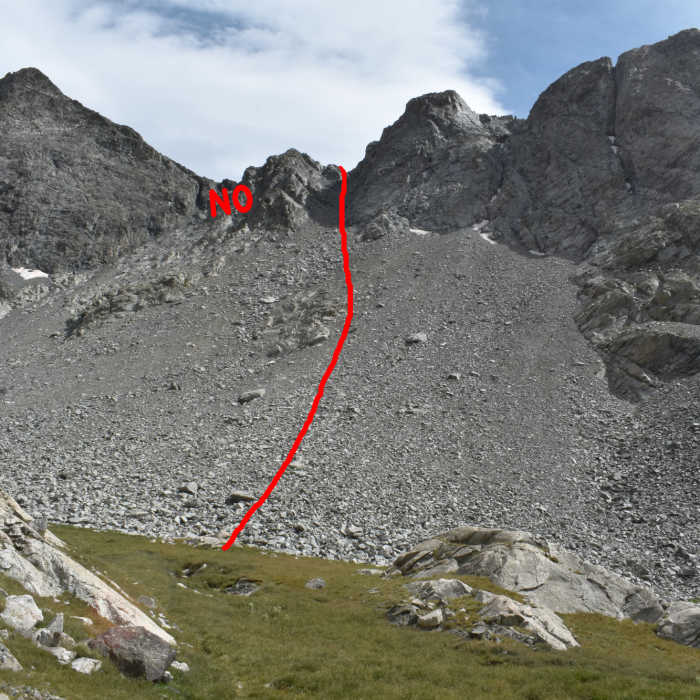
A number of couliors cut Ellingwood's west ridge. Most of them lead to dangerous and loose class-4 and 5 blockages. But there are two class-3 options. The C3 gully leads west from South Zapata Lake up to a point high on the ridge. But hidden from the lake, the C2 gully at the head of the basin is the better option with more stable rock and about one-half a mile less climbing.
From the tundra at the foot of the ridge, locate the C2 coulior (see included picture). In my research, I came across mixed reviews, some over-playing the danger, others underplaying it. But I found it wasn't too bad if you went slow and chose your route very carefully to steer clear of the loose rock. Also, do your research. The 14ers.com website is always where I start. They have the entire route layed out step by step with pictures. For me, the worst part is the lower 660 feet of talus, especially on the return. There are a number of dirt trails threading the rock, but it's easier just to pick your way across on stable boulders. Be sure to check every rock before putting any weight on it.
Once you reach 12,700 feet, the walls close considerably. I found the right wall offered a lot of stable rock with good handholds and footholds. It's class-3, but for the most part, the exposure isn't too bad. Near the top, make sure to locate the notch where the walls pinch together. This is your exit onto the ridge.
Once on the saddle, turn left and follow cairns across Ellingwood's southwest ridge. It is class-2, but steep. At 5.6 miles, the route bulges outward, then pulls back towards the Crossfire Couloir. On the return, DO NOT confuse this for the C2 Couloir. Without experience and preparations, it is a class-5 death chute.
At 5.7 miles, the trail finally turns east onto Ellingwood's west ridge. This is where things get difficult. The east side of the class-3 ridge offers a lot of rugged exposure, while the west has more talus. Nearing the end, you'll reach an exposed blockage below the summit. Gaining this obsticle, scramble across the easier rock to the summit.
No Condition Reports
Contributors

