Size
NA
Boat Launch
Carry-in Launch
Toilet
No
Boat Dock
Overview
Iowa's largest lake features walleye, catfish and crappie. Weeds and wood provide the cover for largemouth and white bass. Fluctuating water levels challenge any angler.
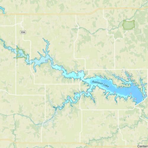
South Fork Chariton River Map
Features
Rathbun lake is situated just southeast of De Moines, Iowa close to the state line with Missouri. The lake was constructed in 1969 to aid in flood control for the Chariton River basin. Nearly 21,000 acres of land surrounds the lake, with nearly 16,000 of those acres leased to the Iowa Department of Natural Resources for wildlife management. Rathbun Lake is the largest lake within the state of Iowa. Most of the lake (and its floodplain) is managed primarily for waterfowl. From September 15 to December 15th nobody is permitted to enter designated waterfowl areas. The two restricted areas are shown on the map. Buoys and signs mark these areas on the lake during this period. Due to shallow areas, submerged trees and other structures lying just below the surface, all waters west of the Highway 142 bridge are considered hazardous boating areas. Summer boat traffic is generally moderate, except for heavy use on weekends and holidays.
Forage
Gizzard shad are abundant in the lake and serve as the primary forage base. Most of the gizzard shad are small enough to provide forage for most game species. Later in the season, some of the population can grow too large to be consumed. Juvenile crappie are utilized by larger species as well. At times, midgeflies and larvae supplement fish diets.
Seasonal Movements
Most walleye, white bass and catfish spawn within the lake instead of moving to inlet areas. However, in spring, the Iowa DNR nets walleye near the dam for spawning stock.
![]()
Get Your Line in the Right Water
Quickly find the best places to fish and plan your day right.