How onX Hunt’s 3D Maps Help You Plan, Scout, and Hunt
The addition of 3D Maps to the onX Hunt App on iOS devices allows you to understand the terrain and use the landscape to your advantage. While the practical uses for 3D Maps are nearly endless, we’ve highlighted a few of our favorites here. Dig into the Hunt App on iOS devices or the desktop Web Map to see how 3D Maps can help your hunts this season.
For years, our Hybrid Basemap has provided a useful combination of satellite imagery and topographic lines to allow hunters to gain an understanding of the landscape. One challenge, though, has been that the mental images of the landscape we build don’t always provide an accurate representation of the areas we hunt.
To enrich your experience, we’ve added 3D Maps to Web Map, which is our desktop version of onX Hunt, and to the onX Hunt App for iOS devices. With the ability to plan, scout, and hunt in 3D, gaining a truly comprehensive understanding of the landscape is now possible. Your specific needs will determine how you use this new feature, so head into the Hunt App and Web Map to put 3D Maps to work for you.
Plan Your Routes
How you move across the landscape is determined by many factors—where you think the game will be, what the wind is doing, what route is safe or feasible, and so on. 3D Maps allow you to plot your route from the comfort of home with the knowledge that what you encounter in the field will come as close as possible to matching your mental image of the landscape. Knowing what to expect means you’ll be better equipped to plan and pack appropriately.
Predict Animal Movement
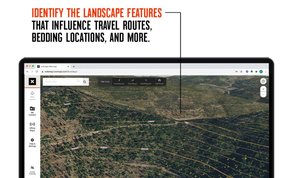
The animals we pursue aren’t that different from us when it comes to picking the path of least resistance when moving across a landscape. Whether it’s a nearly imperceptible saddle used to cross a ridge or a small point where game trails often converge, knowing where animals will be allows you to set up in the right spots. Use 3D Maps to identify the landscape features that influence travel routes, bedding locations, and more.
Visualize Wind and Thermals
Playing the wind matters, and understanding how topography impacts the wind is critical. Even small topographic changes can cause a steady directional wind to shift and swirl in a small area. Remember, too, that thermals reliably cause updrafts in the warming mornings and downdrafts in the cooling evenings. While it can be easy to think of thermals solely as a concern of mountain hunters, whitetail hunters in hilly terrain should also keep them in mind. Use 3D Maps to see how setting up a stand on a small ridge for an evening sit might pull your scent down toward the areas where you expect the deer to be found.
Find Prime Glassing Spots
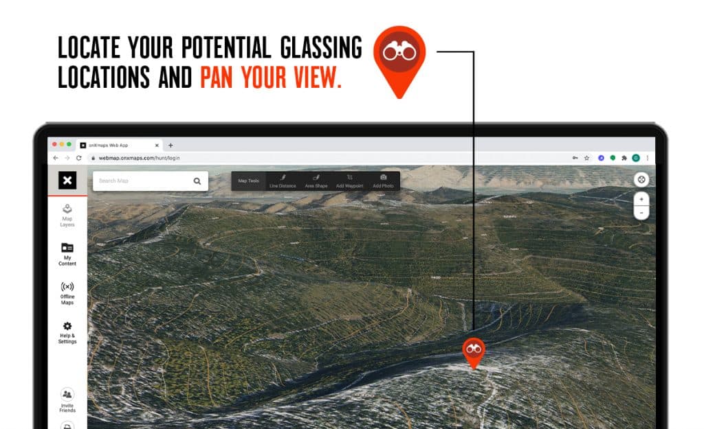
We’ve all been there—after scouting from home on Web Map, we arrive at what we thought would be a solid glassing location only to find that the expansive view we anticipated is blocked by a topographic feature we overlooked. With 3D Maps, you can locate your potential glassing locations and pan your view to ensure that when you arrive, the view you’re expecting matches the view you have.
Tip: Remember to anticipate seasonal changes in leaf cover. Views can open up dramatically once the leaves start to drop.
Identify Small Changes in Topography
On traditional topographic maps, contour lines are often separated by enough vertical distance to make picking out small changes in topography difficult. When hunting elk or turkey, for example, small benches on a slope can be ideal places to start your search as they provide ideal bedding locations for elk or prime gobbling perches for toms. It’s been said a thousand times, but it bears repeating—knowing the lay of the land and building a mental library of small changes in topography is perhaps the most important skill a hunter can possess.
View Your Markups and Relive the Hunt
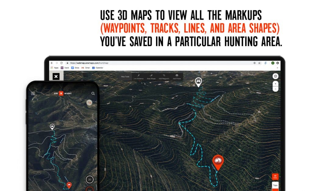
Use 3D Maps to view all the Markups (Waypoints, Tracks, Lines, and Area Shapes) you’ve saved in a particular hunting area. While planning your sit location for a turkey hunt, for example, saved Waypoints showing roost trees, previous sightings, and marked sign come alive with the addition of 3D Maps. Also, we like using 3D Maps to view the Markups we’ve saved on previous hunts while reliving the experiences and telling the stories. That brutal packout on last year’s elk hunt is much more accurately represented when you see your Track winding its way up a steep slope toward the spot where you parked your truck and drank your celebratory, post-hunt beers.
These are just a few of our favorite uses for onX Hunt’s 3D Maps. As you begin to explore this new feature, we’re sure that you’ll find many additional ways in which 3D Maps can make your hunts more productive.
Click here for more information and a quick FAQ on 3D Maps.