
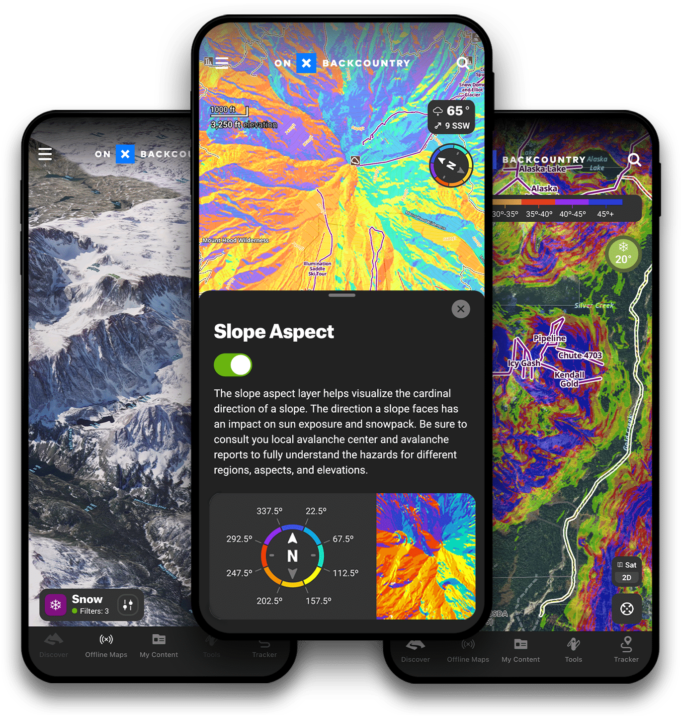
Leadville Race Series + onX Backcountry
Map the race series where legends are created and limits are tested. Proven in extreme Colorado Rockies terrain — from elevations of 9,200 to 12,600 feet. Start planning, training, and mapping NOW!
(no credit card required for trial)
This link has expired. For more information on onX Backcountry, please visit www.onxmaps.com/backcountry.
Go all-in for Backcountry.
Want to skip the 14 day trial and sign up for a full year of the ultimate offline GPS trail running, hiking and ski maps? For a limited time, get 20% off onX Backcountry using the link and promo code leadville20.
Leadville 100 Run Course Map and Aid Stations
There are 13 aid stations along the course, 11 completely stocked aid stations and 2 hydration-only (Coke & Water) stations.
Aid Station 1: Mayqueen (Outbound)
- Outbound cutoff time: 7:45 AM
- Outbound Mileage: 12.6
- Access: **Important** You can only access via CR 9 North of Turquoise Lake. Do not take CR 4, your GPS will tell you to take this way, but do make sure to go counterclockwise around Turquoise Lake.
Aid Station 2: Outward Bound (Outbound)
- Outbound cutoff time: 10:00 AM
- Outbound Mileage: 23.5
- Inbound Cutoff: 3:00 AM
- Inbound Mileage: 76.9
- Access: via HWY 300, look for parking crews
Aid Station 3: Half Pipe (Outbound) NO CREW ACCESS
- Outbound cutoff time: 11:30 AM
- Outbound Mileage: 29.3
Mini Mount Elbert: Hydration Station Only (Outbound) NO CREW ACCESS
- Outbound Mileage: 35.4
Aid Station 4: Twin Lakes Village (Outbound)
- Outbound cutoff time: 1:30 PM
- Outbound Mileage: 37.9
- NOTE: SEE CREW & SPECTATOR TAB FOR INFO ON TWIN LAKES VILLAGE ACCESS
Aid Station 5: Hope Pass (Outbound) NO CREW ACCESS
- Outbound cutoff time: 4:00 PM
- Outbound Mileage: 43.5
- Inbound Mileage: 56.9
Aid Station 6: Winfield (turnaround) (NO CREW ACCESS)
- Outbound cutoff time: 6:00 PM
Aid Station 7: Twin Lakes Village (Inbound)
- Inbound Cutoff: 10:00 PM
- Inbound Mileage: 62.5
Mini Mount Elbert – Hydration station only (Inbound) NO CREW ACCESS
- Inbound Mileage: 64.2
Aid Station 8: Half Pipe (Inbound) NO CREW ACCESS
- Inbound Cutoff: 1:15 AM
- Inbound Mileage: 71.1
Aid Station 9: Outward Bound (Inbound)
- Inbound Cutoff: 3:00 AM
- Inbound Mileage: 76.9
- Access: via HWY 300, look for parking crews
Aid Station 10: Mayqueen (Inbound)
- Inbound Cutoff: 6:30 AM
Finish Cutoff: 10:00 AM
All or part of this operation is conducted on Public Lands under special permit from the U.S. Bureau of Land Management.
This event is held on the San Isabel National Forest under a special use permit.
Course history
In 2021 the decision was made to remove pacer and crew access from Winfield. This was due to overall impact in Winfield and congestion on Hope Pass. This will remain unchanged in 2022 and no pacers OR crew will be allowed access to Winfield.
Aid Stations
There are 11 well-stocked aid stations along the course. Cut-off times for the aid stations do apply.