How To Use onX for Fishing
onX is the perfect tool to make the most of summertime fishing (or fishing any time of the year).
Runoff is settling, rivers are clearing, and summer is officially here. For many, the change of season means it’s time to put the raft or drift boat into daily rotation, trade the wading boots for sandals, fill the cooler with dinner-on-the-water fare, and start eagerly anticipating the arrival of terrestrial season. From dropping a Waypoint to mark your favorite undercut bank to knowing which access roads take you to the water, our maps will help you optimize your time on the water.
It’s easy to use onX to find fishing access, promising runs, boat ramps, fishing spots near you, and more. Here are 10 of our favorite ways to use onX for fishing:
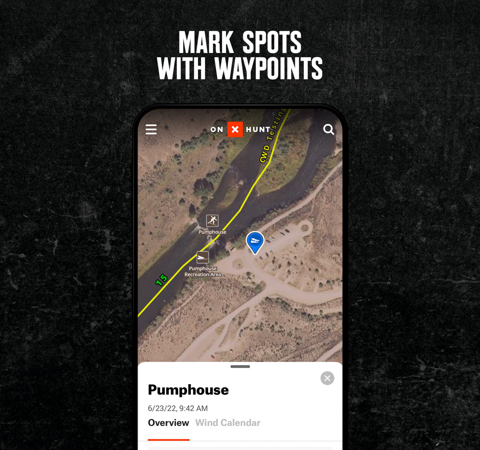
Mark Spots With Waypoints
Easily drop a Waypoint to mark unofficial boat ramps, fishy-looking banks, spicy rapids, that one riffle you caught that monster brown in, or even your favorite break-for-a-beer spot. Waypoints are easy to share with friends via email, text, and more. Wade fishing? Drop a Waypoint at the truck so you can focus on the water, not on remembering the trail. Heading out solo? Drop a Waypoint at the trailhead or boat ramp and send it to a friend with a note on when you’ll be off the water.
Download Offline Maps
No cell service? No problem. Download Offline Maps before you leave home, ensuring you’ll have all the info you need when the cell towers become scarce. Easily download a section of map and save it to your phone—your phone’s GPS-enabled receiver accesses the same satellites as GPS units and will still be able to show your location once you leave cell service.
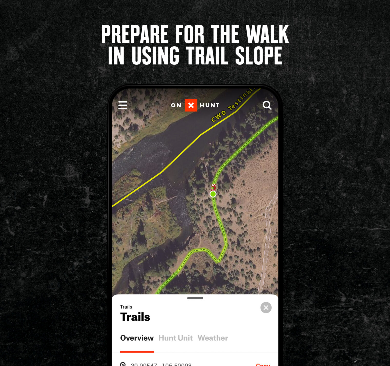
Prepare for the Walk in Using Trail Slope
Ready to chase blue lines and log some trail time in order to access backcountry fishing and beat the crowds? Turn on the Trail Slope Layer, in the Trails & Rec Layer drop-down, and trails on your map will begin to glow green, yellow, orange, and red, indicating the slope. Craving a mellow hike in? Look for green. Want a serious conditioning hike with an added bonus of trout at the end? Orange and red is your zone. Use the Trail Mileage Layer to show the length of trail segments from one endpoint to the next.
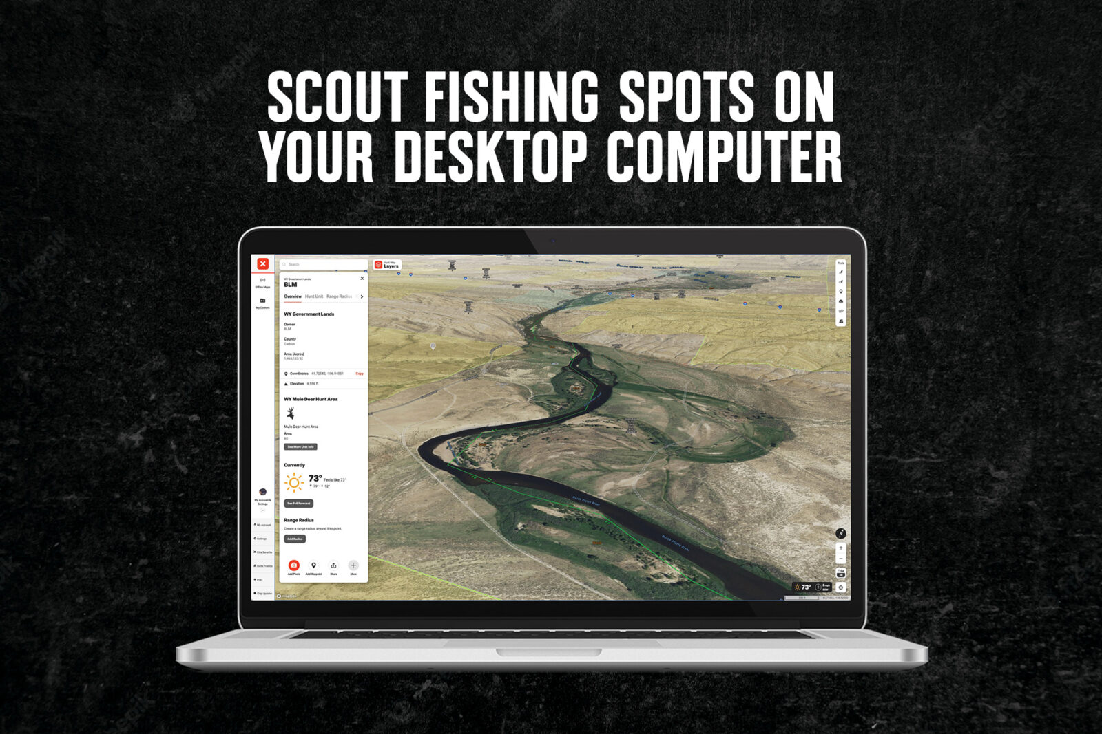
Scout Fishing Spots on Your Desktop Computer
Don’t spend your time on the water squinting at your cell phone screen. Coming to the dawning realization that polarized sunglasses and cell phone screens make life difficult? Miss your shot at that nice riser because you were fiddling with your phone? 3D Maps on your computer make life easier—access maps on your desktop, laptop, or tablet from the comfort of the couch and mark your Waypoints or trails before you hit the road. Remember to download Offline Maps if you’re planning to lose cell service!
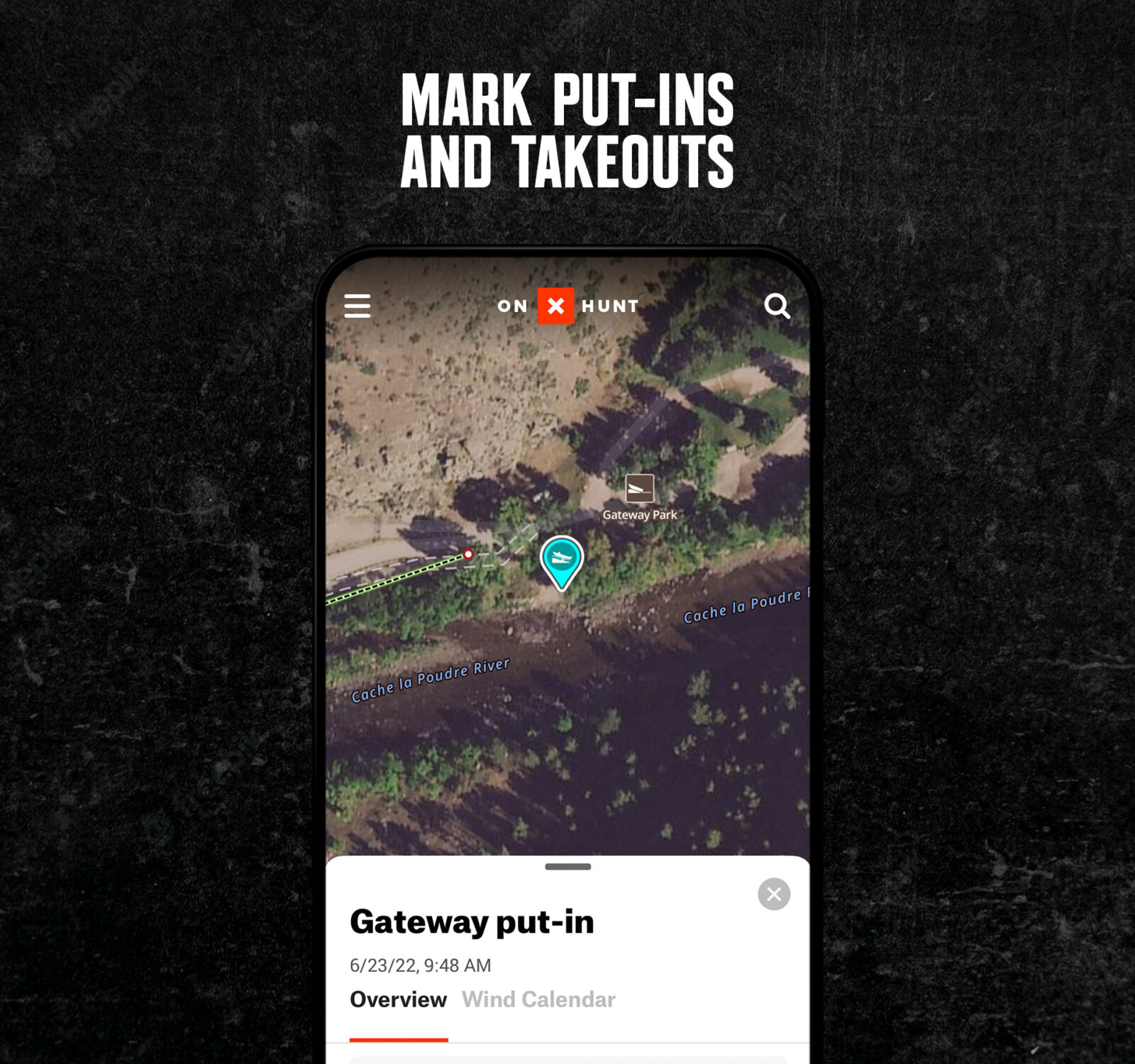
Mark Put-ins and Takeouts
Add the Points of Interest Layer to see fishing access and boat launch sites. Exploring new waters and need an access site? Had a long day rowing upwind and it seems like you’ll never reach the take-out? A quick glance at the map will show you’re not losing your mind… it’s just a couple more bends down. This is great for anyone looking for a day trip, or for finding put-ins and takeouts for multi-day floats.
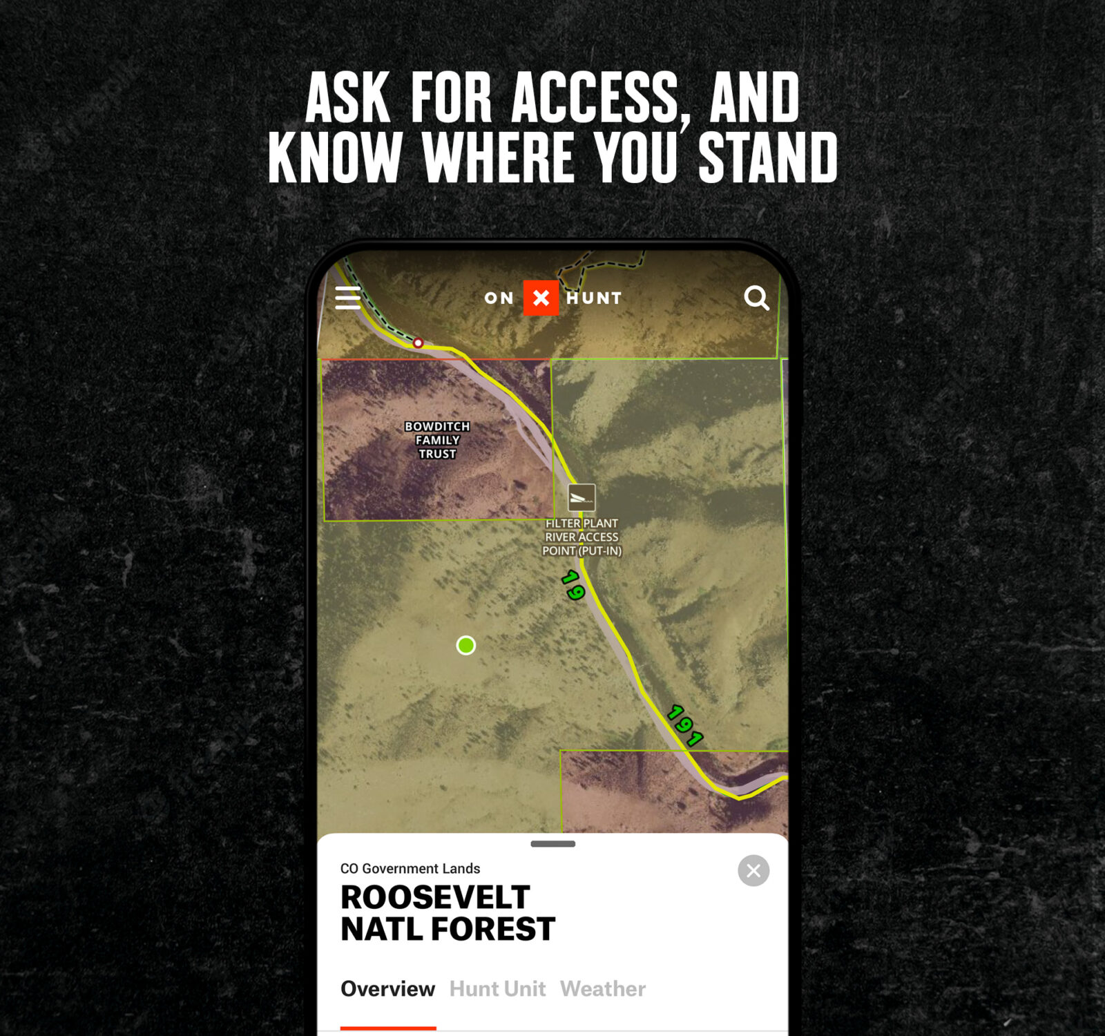
Ask for Access, and Know Where You Stand
Private land boundaries are clearly marked in the Hunt App—with information including the title holder’s name. This is a great asset to anyone fishing from the bank. Just turn on the Public/Private Land Ownership and check to see if you can cross a stretch of land, to get to the section of water you want to fish.
If you do find a piece of private property between you and an irresistible section of water, check out the landowner information and ask for permission to cross onto your new fishing hole. Knowing who owns the property gives you the ability to find the best way to access a good-looking stretch of water. Wondering if you should knock on a door to see if you can pass through someone’s land? Look on the App for their name and approach the door with a smile. Know where you stand—no one likes to wonder if they’re trespassing or not. (Waders are not meant for sprinting.) Just turn on the Public/Private Parcel Data Layer to see what lands are public.
Track Your Path
It’s easy to record your path as you travel—it serves as a convenient reminder how to find that one hidden trailhead that leads to a long hike that is (finally) rewarded with plenty of fish at the end. Tracker records an accurate visual representation of your path, time, distance traveled, and average speed. (This is also a great tool for conditioning hikes before the hunting season arrives!)

Utilize Aerial Imagery to Plan
The onX Hunt Satellite Basemap uses aerial imagery to provide a clear image of the terrain ahead. Users are able to identify major features like massive roads and trail networks. Low and medium levels of zoom are almost completely cloud-free with up-to-date imagery. The map provides details that allow users to identify tree cover, rocky outcroppings, and other terrain features.
This is a great scouting tool, giving you an updated idea of what your river, lake, or creek looks like. Use it to study river bends, or plan your trek from the truck to the river. You can also use the Topo Basemap to understand how steep your route to the water is.
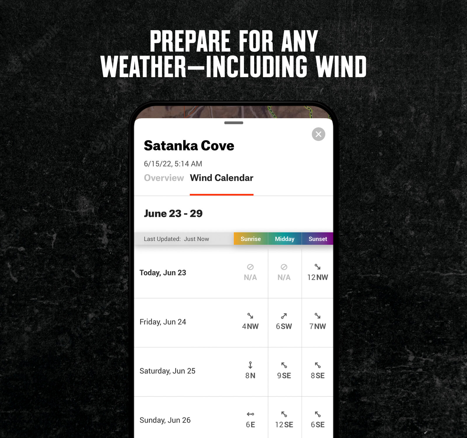
Prepare for Any Weather—Including Wind
Weather plays a key part in the success of any fishing trip. With the Wind & Weather feature, the onX Hunt App displays the most up-to-date weather reports available for the exact area you plan to fish. No more getting weather updates by searching a zip code or the nearest town to your remote fishing spot. Simply touch the map where you want information and see forecasts, wind direction, precipitation, high/low temperatures, barometric pressure, and more—all in one convenient location.
Understand Access Roads
You can’t fish a new stretch of water if you don’t know how to get there. The Motorized Roads & Trails Layer shows you everything from major highways to logging roads, so you can navigate to new fishing water anywhere in the country.
Whether you’re hiking in while hoping for your personal best cutthroat, loading up the boat for a day of chasing bass with your buddies, or chasing stripers in the salt, onX Hunt helps you make the most of your time on the water. Share your favorite fishing hole with Waypoints, or keep it secret and ensure you remember the way in using Tracker. Explore new terrain and waterways with desktop maps, and ensure you know where you’re standing—even in the backcountry—with Offline Maps.
Fresh or salt, wading or in a boat, onX lets you focus on the fish.